
High Sierra
Backpacking
Trail Guide
Forums
Sierra
Weather
WeatherNotes Northern
Sierra Weather
Gear
The Tahoe to Yosemite Trail
Meeks Bay Trailhead
Long Distance Backpacking
Trip Planning, Mileage
&
Hitting the Trail
PLANNING |
--and-- | MILES & ELEVATIONS |
--And Finally--
Hitting The
MEEKS BAY TRAILHEAD
of the
Tahoe to Yosemite Trail
Languages
Trail Skills
Mountain
Safety
Food
Planning
Trail Arts
More
Information
Social
|
|
|
|
Topo Map Meeks Bay to Dicks Pass |
Miles & Elevations Meeks Bay to Echo Lake |
Miles INDEX |
PERMITS Lake Tahoe Basin Management Unit |
All |
All |
Hiking
the
Tahoe to Yosemite Trail
Meeks Bay Trailhead AN
An Introduction Backpacking
Backpacking the Tahoe to Yosemite or Pacific Crest Trail routes South from Meeks Bay Trailhead to Tuolumne Meadows entails hiking five distinct sections of trail across six wilderness areas crossing four trans-Sierra highways. These four highways sport three resupply spots over a span of roughly 173 miles.
Let's Conceptualize
Let's start building a great mental image of the Sierra in our mind. We'll start by creating a framework of abstract information reflecting the requirements the environment of each section demands of us. Then we will test our concepts, our plans, and ourselves in action.
Map Resources Note |
North Sierra Wilderness Areas
Continuing South out of the Tahoe Basin the PCT and TYT
Our final run of the Tahoe to Yosemite Trail in the N Yosemite Backcountry brings us across the... Five Canyons of the North Yosemite Backcountry
Click All the maps above also link to the maps North and South of their areas of coverage.
Miles
Our goal is to use the maps, miles, and guide information to ascertain the best route, or combinations of routes, for each of us. If we already know our route, we will use this map and mileage information to better assess and tune our food, time, gear, and energy/endurance requirements to the level demanded by the mileage and difficulty of each section of trail.
Route Options Our route options continue within each section of trail. We can tie segments of both trails together as we hike across the Carson Iceberg and Emigrant Wilderness Areas. On the other hand, we can really "pump up" our hikes across the Carson Iceberg and Emigrant Wilderness sections by tying different segments of the PCT and TYT together across these two wilderness areas.
Trans-Sierra Highways Schematic |
North Sierra Resupply
Echo Chalet is the first (resuppy) point we encounter hiking South from Meeks Bay where food and drink are available. We could potentially cache a resupply here in a car in the parking lot. Hiking from Meeks Bay to Echo Chalet crosses the full length of Desolation Wilderness.
High Sierra Backpacker Resupply Spot
(See the Whole Sierra Introduction.)
|
PCT-TYT
Unified Northern End SE or SW
Their Divergent Center
Unified Southern End
Omission
No Highway Hiking
Yikes! Hitch-hiking from the Sierra Crest to Kennedy Meadows (guide)
PCT-TYT Our TYT route tracks across the Western Flanks of these same Mokelumne, Carson Iceberg, and Emigrant Wilderness Areas while the PCT stays up on the Sierra Crestline & high up along their Eastern flanks.
|
The
Map Notes
We discuss and compare the |
North Sierra Tahoe Area Resupply You will note that Echo Chalet no longer provides a mail-in resupply package service. Highway 4 The vast majority of the annual Northbound hoard of PCT hikers bypass the resupply stop at Lake Alpine. That's their loss. One of the casualties of the need for PCT speed is missing valuable experiences. I consider Lake Alpine and the terrain around it as one such loss. The standard resupply pattern of PCT hikers across the North Sierra is across the 75 miles from Tuolumne Meadows to Kennedy Meadows followed by the 75 miles from Kennedy Meadows to our Lake Tahoe Basin resupply. Highway 108 While the Pacific Crest Trail drops into and out of Sonora Pass, the route of the Southbound Tahoe to Yosemite Trail continues South from the Highway 108 corridor out the South end of the The road out to Kennedy Meadows Pack Station is located on Highway 108 a little over nine miles West down the West Flank from the Saint Marys Pass Trailhead, being a little less than ten miles West of Sonora Pass. Down to KM We TYT hikers will pick up our last resupply for this last and longest section of our Tahoe to Yosemite Trail, this final 75 mile section of the TYT down to Tuolumne Meadows, at the Kennedy Meadows Pack Station Store. I also take the opportunity to eat some good food, rest up for the hard terrain down to Tuolumne Meadows, and hang out with the staff, customers, backpackers, cowboys, hunters, horsepackers, and fishermen at Kennedy Meadows Pack Station. |
Contrast and Compare The Trans-Sierra Highways The North Sierra Trail Sections The trans-Sierra highways across the North Sierra can help us organize a clear understanding of the unique characters of the terrain in each of the wilderness areas between them.
Once we ascertain mileages and elevations of each section of trail between our trans-Sierra highway resupply points we can focus on understanding the important differences between the TYT & PCT routes. We can see that the TYT demands much higher levels of observation, analysis, then free-form engagement with the terrain than the PCT. The TYT requires sufficient degrees of skills and fitness to deal with segments of very demanding unmaintained trails and routes (definitions) along the TYT. Character Differences The profound physical differences are due to the very different aspects the East and West Flanks of the Sierra have on regional weather patterns and their very different geological histories within their shared overall history. These climatic differences magnify these two trail's very different expressions of the Sierra's shared geological history. Variety of Experience I'm talking about you, Mr. Allspice! The TYT is a very different trail than the PCT in trail conditions, the surrounding terrain, and its skeletal hiking culture. These factors combine to make the TYT a very different experience than the PCT. It is much more difficult, more isolated, infrequently traveled, and occasionally ambiguous, frequently elusive, even absent across its more interesting segments. These very interesting conditions draw out different and unique types of backpackers than those who trod maintained trails. Our expectations must be tuned to, and prepared for the extra demands these conditions create. Responsible Route Finding A good thing is that the difficulty of the unmaintained and untrailed segments of trail scattered along the length of the Tahoe to Yosemite route work to mitigate the annual overcrowding we experience hiking the PCT and JMT routes along the Sierra Crest. Fine Balance My expectation is to enjoy every physical and social environment I encounter. Even the painful ones. The true Joy of engaging Nature across long time spans and distances is composed of fully experiencing its attendant metaphysical pains and pleasures as we rise above them into quite unique zones of perception. PCT vs. TYT The granites we do see are magnificent. Dropping into then climbing through the headwaters of the East Carson River along the route of the PCT shows us ancient granites that were long ago buried by volcanic eruptions that are now emerging, being slowly eroded out of their volcanic prison. The TYT Lake Alpine We are tracing out an ancient interface. Our last great climb to the Sierra Crest begins out of our next resupply spot at Kennedy Meadows Pack Station. Like out hike up the Clarks Fork, we trace out a long volcanic-granite seam following Summit Creek back up to the Sierra Crestline climbing across the highest elements of Emigrant Wilderness. From that point both the PCT & TYT will be West Flank trails crossing the challenging The Range of Experience Thus the natural and administrative divisions of the Sierra are reflected by the organization of the trans-Sierra highways. Tahoe Basin Highways Trans Sierra Highways We note the line of the Sierra Crest is rising in elevation as we hike North to South from Tahoe to Yosemite. This trend continues from Tuolumne Meadows South all the way up to the top of Mount Whitney. North Sierra
North Sierra This offset requires we hitch-hike (guide) West down each of these mountain highways to resupply followed by a hitch back to the crest to resume our hike. Echo Chalet is an exception, being located along the route of the PCT-TYT on the South end of Desolation Wilderness. The Range of Experience This guide follows both routes South to Tuolumne Meadows, so we can scout-out both of them from here.
|
Trail and Terrain Life is a balance of contradictions and tradeoffs. Most of the TYT's Western Flank route that diverges from the PCT is below the volcanic zones of terrain covering the Sierra Crestline. This vulcanism dominates the vast majority of the PCT's crestline route South of the Tahoe Basin to Tuolumne Meadows. The majority of the PCT's crestline route is through volcanic terrain almost all the way down to the PCT's entrance into North Yosemite. Which Side of the Line? TYT hikers on the Western Flank move up & down and across an endless series of major and minor granite canyons full of rivers, forests, and meadows. The major canyons the TYT encounters are Summit City Canyon, the North Mokelumne, the Clarks Fork of the Stanislaus, and Summit Creek above the Middle Fork of the Stanislaus River. This list omits a long line of minor canyons. The Five Canyons of the North Yosemite Backcountry Trail Conditions If you do not accept route-finding as part of the TYT, then don't hike it. I have observed many times that "strong and stupid" have a strange balance... haha. But, I would rather not rely on blind strength and stupid luck for good outcomes. Then we get lucky. That's "Smart Luck."
|
Section Hike Backpacker Treats There is a whole population of long distance backpackers pursuing the long trails one section at a time. They are logically called, "Section Hikers." Sierra-centric Though we will hike sections of trail and grand backpacking loops that include trails and trailheads off the line of the Sierra Crest, each of these supporting trails and trailheads is either bringing us to or from our true goal: hiking the Sierra Crestline trails. We are Sierra-centric here. All backpackers are always welcome on the Tahoe to Whitney Trail Guide, but the Sierra Nevada is the center of our universe here. Another Link in the Chain Unique Routes The Unmaintained NEW This segment of trail has been added to the two existing unmaintained-status segments of trail along the route of the Tahoe to Yosemite Trail. North Mokelumne to Spicer Meadow Reservoir Forum Uh-Oh Sadly, the forest fire here was timed with the beginning of the long-term reduction in snow and precipitation the Sierra has experienced over the past thirty-plus years. This new emergent weather pattern appears to have been, and is continuing to deny this burned zone the moisture it needs to regrow over the long-term. This is a "growing" problem. The Southernmost segment of unmaintained trail challenges us to find the optimal route climbing out of the South end of the Carson Iceberg Wilderness (trail guide) through Saint Marys Pass. In the middle of the TYT we now find this forest of fallen snags obscuring our route. The Tahoe to Yosemite Trail is fully maintained South of Saint Marys Pass and North of Summit City Canyon. But we may well find bits of unmaintained trail outside of the known unmaintained segments of the TYT. Unmaintained TYT Trail I discuss the dangers of hiking unmaintained trails and further certify my seriousness about the inherent difficulty and danger of High Sierra Backpacking in this site's As I like to say, Nature can tear us up. I just try stay out of the way and not get squished by & "Sometimes dancing through life requires running for your life." BE READY Other than those caveats, hiking from Tahoe to Yosemite to Whitney has the potential to be one of the most beautiful, engaged, and rewarding experiences of our lives. It was so fun that I caught on fire the last time I was in the mountains... Meeks Bay Trailheadinto Desolation Wilderness Maps--Miles--Elevations
Meeks Bay to Echo Summit Miles
Local Trail and Town Resources
Lake of the Sky Outfitters
The All backpackers can post text comments about the Meeks Bay Trailhead page of the Desolation Wilderness section of the trail guide. All of our thoughts are pretty-much focused on looking as far down the trail and as deeply into ourselves to ascertain accurate information vital to plan and prepare for hiking the Tahoe to Yosemite Trail. That's what we're dealing with through the comments links on this page. Also check out the Planning Forum too. Every trail guide page has comments links because I seriously want to hear your updates, experiences, and perspectives planning and hiking these remarkable trails. Every segment of our trails down to Mount Whitney can be reflected on, disputed, corrected, commented up, questioned, or updated by us and our fellow backpackers. Post up your latest adventures to keep us current. I would like to see your response to both the objectivity of the miles figures I give, and the subjective trail descriptions of trail and terrain. This is important, as different backpackers have different capacities, expectations, and very different perspectives on exactly the same trails. Some parts of the route are literally "etched in stone," cut through timeless unyielding granite while the trail through meadow and forest are in constant flux. Registered Members can post up text, images, maps and embed videos in the Trails Forum to supplement and update this page's coverage of how we approach Meeks Bay Trailhead. In any case, check out the Tahoe to Whitney .org |
||||||||||||||||||||||||||||
Let's Get Started!
Hitting the TrailThe first steps of any backpacking trip are exciting. Hiking the 175 miles of the Tahoe to Yosemite Trail is very exciting. Hiking past Yosemite to Mount Whitney on the JMT begins a 40+ day High Sierra experience we will never forget. We've planned, trained, and sent out our resupply packages. We review our preparations below, then Hit the Trail. |
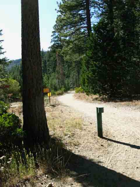
This is looking off to our Right, to our North-Northwest, while a diminishing meadow sits off to our Left. |
Rough MileagesTahoe to Yosemite Trail Tahoe to Yosemite (PCT route) NOTE Tahoe to Whitney We can really stretch out the (more below) |
|
Highway 108 No Highway Miles I generally pick up a ride hitch-hiking across this segment of "trail," being our second "road" segment along the TYT. Our first road segment was from Arnot Creek Trailhead up to the Clarks Fork Trailhead along the old Clarks Fork Road. I happily walk the Clarks Fork Road. It is amazing how many car campers are out there during the height of the Summer Vacation Season. Why Not? The nice paved country road out to KM from Highway 108 is cool for peds, if you watch out for cars, as is Clarks Fork Road. I rode my fully modified 1978 GS 1000 superbike very fast over Highway 108 many-many times in the late '70s and '80s. These are fine roads for safe and careful sportsmen! Personally, I don't like to walk down Highway 108. I hitch from Saint Marys or Sonora Pass down to Kennedy Meadows. Highway 108 is a great road for a biker, but not the best for a hiker! I hitch-hike. Hiking the 9.32 mile hike down Highway 108 (including the mile out Kennedy Meadows Road to the gate) brings the total of the Tahoe to Yosemite Trail to |
Preliminary Issues
First Things First
Getting Ready High Sierra Trails are among the most difficult trails. They involve oxygen depravation due to altitude, very steep trails, rough terrain, and we can get ourselves long distances from rescue or medical services. Other local or seasonal risks include the Spring Thaw making fording dangerous, Summertime lightening and downpours from local and/or tropical thunderstorms, unexpected temperature declines, and classic unexpected North Pacific storms out of the Northwest rolling through. Successful long distance backpacking trips are built on the foundation of a series of short backpacking trips designed to build our experience, fitness, and gear to properly and safely address long distance high altitude High Sierra trails, and safely deal with the issues that do arise during our trips. Adventure is adventure because it is challenging. A series of short trips will build both our physical skills and experience, as well as allowing us to determine our gear, food, and even our rest requirements. Every backpacker has different tolerances for hot and cold, different demands of hunger and thirst, different capacities of strength and endurance, and different levels of understanding to interpret the significance and meaning of our experiences. A series of short trips allows us to accurately assess our personal capacities and skills. Our goal is to integrate our growing experiences into effective practices, sharpening competence up to minimum High Sierra standards. We're going to do this by properly matching our skill and fitness to a progression of increasing difficulty backpacking trips we are capable of successively completing without suffering too much. Now that's a plan! After mastering ourselves and our Summer skills we will begin probing cooling conditions until we finally enter the snow covered mountains. Training to determining our capacities are always our first steps to prepare us for any major backpacking trip. It may only take a little work to get our skills and fitness together, or it may take some time and effort to get in shape and readiness for the long trails. It depends on what levels of fitness and experience we are starting from, and how consistently we pursue our training and prep trips. You flat landers in Florida and the Great Plains gotta find some stadium stairs to train on. How you It's don't have to be like that, if we properly prepare ourselves.
Emergent Capacity That's heavy. We have two ways to address this: We can increase our carrying capacity or decrease our load. This simple source of fundamental pain is the Mother of Invention that birthed My approach is to gradually build strength over time, matching the increasing challenges of my backpacking trips with my gradually increasing fitness and skills. The Weight of Responsibility Clarity through Pain. We train to make ourselves safe, secure, self-perpetuating mobile mountain observation units capable Though carrying the weight of responsibility initially weighs us down, it ultimately sets us free. The hard part is making the physical and psychological transition from modern to natural assumptions as smoothly and painlessly as possible. Fitness is a great help. Once we make this transition we will be fine. Better than fine. The key is not to break ourselves, our kids, or our significant others while making the transition. Reality Exists Gradualism On the trail each backpacker supports their own assumptions. I have seen this state of being more times than I can count every Summer. We will be in real trouble if a cold rain falls and we cannot remain warm, dry, and well-fed under such stressful circumstances, especially while exhausted. I would much rather that the factors of success come together under stressful situations than fall apart. Our training and prep trips give us the best shot at pulling a rewarding success together when things get sketchy. That is very fun. Very serious fun. We will find that reaching out and engaging Nature using our increasing physical and perceptive tools brings deep rewards and true joy through hard work, sweat, strains, and pains that are unobtainable in the human-created world. Our "investment" in our own health, fitness, and natural engagement skills radically resets our This is living joy rather than passive entertainment. This type of work in Nature will fix up your mental and physical abilities to engage and enjoy all experience, let alone Nature Itself. These practices heal the body and soul from the physical and spiritual damages the evil of our times have done. Me: My Best Frendemey Do It... Every section of this trail guide across the North Sierra is full of short and medium distance in-and-out backpacking trips, trail segment backpacking trips from point "A" to point "B,"and longer backpacking loops that can be crafted by tying together lengths of the Tahoe to Yosemite and Pacific Crest Trails around the North Sierra wilderness areas. Don't start with a long, hard, high, backpacking trip. We'll get there soon enough! WHICH IS YOUR FAVORITE WILDERNESS? Backpacking the Sierra can be a fine year-round activity supporting a lifetime of strength, clarity, and fitness. READY |
HOPP
The Harness of Pain and Pleasure
Prior to getting started on the long trails we have a number of specific external and internal issues to engage. External Prep Internal Prep Internal issues are our physical, emotional, intellectual and spiritual capacities we use to address the trip's external requirements. Our "external" perceptions write the check, the internal assets cash it. The Marines sharpen tools hard and fast. I suggest a more reasoned approach. How well our external planning and assessments are matched to our internal levels of fitness, skills, and gear needs determines if our plan is valid. Our balance of Pain and Pleasure lays in the accuracy of our plan matching our capacities. We are shooting for fun! Real Hard Fun, but Real Fun nonetheless! If we have balanced our capacities with our trip properly, we will be fine. The greater the mismatch between plan and capacities, the greater the potential for struggle, discomfort, fatigue, and disaster. We've got to see our internal and external factors at play clearly, tell ourselves the truth about them so we can balance them our as the foundation of a very-very fun Tahoe to Whitney backpacking adventure. Our goal is a Dream Trip, rather than an Ambulatory Nightmare. Dream or Nightmare is determined by how effectively we've balanced our skills, fitness, and gear against the requirements of our trip. This is a very serious form of fun, as you can plainly see. The balance of our pleasure and pain, and maybe even our lives, lays in the accuracy of our analysis. That's FUN ! |
Balancing |
||
External Issues
Pace
|
Internal Issues
Getting Started
|
Our plan and our ability to execute our plan must be reasonably close. Pain, injury, failure and even death results when our internal and external requirements fail to match and balance. The more pain we experience on the trail, the less we will see, and even less will we understand and enjoy. This pain will condition our experience towards dreadful from delightful. Be Ready. |
|
| HOPP The Harness of Pain and Pleasure  Where's my Tool? You, you there! Put me on! Now! Hike! Hike Faster! |
|||
Many of these issues are not restricted to backpacking. Balancing the internal and external aspects of our lives is always good practice. |
Information Mileage Information Lake Tahoe to Tuolumne Meadows Below we lay out the North Sierra mileages to get some context on the differences between the Tahoe to Yosemite and Pacific Crest Trail routes between Lake Tahoe and Tuolumne Meadows. The differences in mileage between the PCT and TYT sections are not so great, and are certainly We discussed the significant physical differences between the routes above, and on the TYT page: The Most Important Difference Hooray for the Difference Plus, if you screw-up the physical demands can become very. very difficult. Dangers of Backpacking, New Unmaintained Addition CLARKS FORK Detail We will begin to look Right, for the channel up through the cliff face to our South, once we get around and above the North side of Clarks Meadow. Difficult Miles Take Longer Maybe even a whole lot more time and effort to hike across, if we can't find or stay on the optimal route. A Different Experience
North Sierra On the page below we break down the specific mileages of each section of the Tahoe to Yosemite and Pacific Crest Trails hiking South to Tuolumne Meadows. We add up the cumulative totals for each route as we hike South across each successive wilderness area. We keep running totals for both trails as we hike section-by-section from Lake Tahoe down to Tuolumne Meadows. Below we take a look at the total miles of each section of trail from Tahoe to Tuolumne Meadows from a "top-down" perspective, looking at each section of trail as a discrete element woven into the overall plan and span of rest of the sections making up our hike. Each section of our two trails South to Tuolumne Meadows, both the TYT and PCT, each stands out as a unique pearl of hiking experience. The overall length of our hike is built from just how we tie these sections, or series of sections, together. We can measure out to the number of trail sections required to reach the desired length of our hike, which can be designed and approached as a stand-alone "section hike" using elements of the TYT and the PCT across the North Sierra. Broken down into their natural sections between trans-Sierra highways, the TYT and PCT offer a range of backpacking "section" trips along their lengths down the North Sierra spanning from a bit less than thirty miles to a bit over 75 miles. We can create trips of almost any length by breaking down or tying together the individual sections of PCT and TYT trails through the North Sierra. Indexof North Sierra Miles
The West Tahoe Basin
The South End of the Lake Tahoe Basin
The Pacific Crest Trail
The Tahoe to Yosemite Trail
The Tahoe to Yosemite Trail
The Pacific Crest Trail
West Emigrant
East Emigrant
Pacific Crest Trail
The Tahoe to Yosemite Trail
Pick your Pleasure A Final Backpacking Trip Assessment: Also see Each of the sections of trail between highways measured above is an excellent section of trail to hike on it's own, as a "section" of the PCT, TYT, or Tahoe to Whitney Trails. Better yet, each of these wilderness areas between resupply spots/highways can also be hiked as a grand loop. Well, the Carson Iceberg and Emigrant Wilderness can be looped pretty easily. The terrain in the Mokelumne Wilderness makes hiking loops up there difficult. My favorite loops in the North Sierra Nevada Mountains involve hiking the PCT in one direction and the TYT in the other around the high elevation portions of the wilderness areas we cross on our Tahoe to Yosemite and Tahoe to Whitney Trails. Throw in a couple of connector trails, and we have some fine loops around the North Sierra wilderness areas. Long vs. Deep We can easily craft 50 to 90 mile loops around the North Sierra wilderness areas. It is a bit harder to do that around the Mokelumne Wilderness, but we can hitch-hike up and down the Highway 4 corridor connecting the PCT at Ebbetts Pass with the TYT at Lake Alpine to close the South end of our Mokelumne Wilderness backpacking loops. Or we can close the South end of the loop using the Highland Lakes Trail to connect the TYT & PCT. You can see that I believe that developing long distance backpacking capabilities imparts the ability to much more deeply enjoy and exploit the potential of shorter trips. The less we are physically encumbered the better we can explore our environment. You should develop this long distance hike power if you do not have it. If you do have long-distance backpacking "superpowers," you should apply them to closely exploring shorter lengths of trail and even whole wilderness areas. You will be amazed at what you see if and when you speedy long-distance backpackers slow down a bit... This is hilarious. Everyone needs a little balance.
|
TRAILHEADS SOUTH of MEEKS BAY
Eastbound Trail Junctions along PCT-TYT to Lake Tahoe Trailheads
Short Trip Exits South of Meeks Bay
 |
in
North Desolation Wilderness
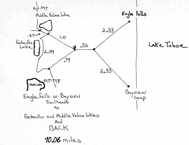
Eagle Falls and Bayview Camp We can hike from Meeks Bay to either as a nice little North Desolation Wilderness backpacking trip, or we can hike a loop starting out of either Eagle Falls or Bayview Camp that hikes around Fontanillis and Middle Velma Lakes before returning to the trailhead. The climb out of Eagle Falls and Bayview Camp Trailheads is considerably steeper than the climb out of Meeks Bay, but much shorter in length. The second trail junction South of Middle Velma Lake leading Northeast to Eagle Falls and Bayview Camp Trailheads is 12.69 miles South of the Meeks Bay Trailhead. From that trail junction it is 3.89 miles to either Eagle Falls or Bayview Camp Trailheads, for a total length of 16.58 miles. Check out the diagram above in conjunction with the Meeks Bay Trailhead Map. These are the closest trailheads we can run a point-to-point Check out the North Desolation Wilderness Backpacking Loop This segment of trail paralleling the PCT-TYT to the West from Camper Flat South through Rockbound Valley can compose the "turnaround leg " of grand Desolation Wilderness backpacking loops starting from any of the trailheads surrounding Desolation Wilderness. Check out the South Desolation Wilderness Map, which shows the Eastern Leg of this backpacking loop through Rockbound Valley via Camper Flat and the Eastern Leg of our potential loop using the TYT from the North Shore of Lake Aloha to Middle Velma Lake. Also inspect the massive Full Desolation Wilderness Map to understand how this loop in North-Central of Desolation Wilderness is situated in context of surrounding trailhead access, including those from the West administered by the El Dorado National Forest. Desolation Wilderness Map Index
|
Previous Page: FINDING Meeks Bay Trail Head top of page Hiking South: Desolation trail junction
Let's get Started!Making Our Tahoe to Yosemite TrailHiking PlanWhat are the Principals and Practices for Successful Planning Complex Long Distance Backpacking Trips? The PreliminariesATMOSPHERICS
High Sierra Weather Information Each Year is Unique Monitoring Seasonal Transitions We need to figure out how this year's snowpack will breakdown into Spring. Our goal is to ascertain the unique progression of each year's Spring snow backpacking conditions into Summer's open trails, follow the declining Sun and temperatures through late Summer into Fall, and finally the progression back into the depths of Winter, when Nature begins charging-up the cycle again. Ascertaining Seasonal Character and Trends All of these weather trend observations over Winter into Spring are vital for backpackers to properly time their departure dates and tune gear selection to the specific evolution of each year's conditions as we find them in the sky and on the ground. Right Now, we're tracking the character of Fall of 2017 into the Winter of 2018 Check the Magazine for Spring into Summer of 2018, when it happens. Adjusting the Backpacker Only careful observation and analysis of the weather and its trends will balance our trip's plans and our personal expectations against the actual realities we will experience in the sky and on the ground during our trip dates. Traditions, Trends, and Traps Trends Traps Hot Mess Current Trends Winter has been slowly shortening over the past decades, and has virtually disappeared for at least the duration of our drought. It will return, and we must be ready when it does. This new pattern has given many backpackers the impression and expectation that the High Sierra Trails open in May and close in November. They do not. Well, not reliably, which gives me concerns for the safety of early and late season backpackers. Snow in May and June during Spring should not be unexpected, nor should bouts of early-Winter snows falling in October be surprising. Buyer Beware This fact requires that we always enter Spring conditions knowing what the odds are that a late-season freak Winter/Spring storm could quickly lay down two feet of powder snow. This would cover our trail and radically change the look of the terrain and likely obscure our landmarks. Two feet of unexpected snow makes hiking very cold and very difficult. Even desperately difficult. This is the source of both great risk and great pleasure for Backpackers who venture into the High Sierra during early Spring and late Fall. Be perfectly aware of them before departing. Backpacker Be Ready Also see our
Annual Planning Practical Goals We previously discussed the Then we have to assess and train up our physical skills to suit our task. Once we have developed the skills, fitness, experience, and gear to successfully hike from Tahoe to Yosemite we will be fully fit, capable, and checked out for hiking the Tahoe to Whitney, the PCT, the AT, or any other long trail. But use caution. Once you put a foot on the trail you may never get off again! Most typically through lightening strikes and failed fordings, but improperly insulated hikers who are cold and tired die of exposure on a regular basis. Thus we will observe the character and progression of the season we backpack within, to make sure our expectations fit the reality on the trail. If we have backpacking experience, we must make it current. We must brush the rust off our skills, and recharge our physical fitness. All prospective long distance backpackers should plan a series of increasingly longer and more difficult hikes to bring our field skills up to speed. We need to have a good understanding of our current comfortable backpacking endurance capabilities long before we hit the trailhead. Find Your Feet These trips will give us all the specific information about ourselves that we need to understand and plan long distance backpacking trips appropriate for our capacities. Meeks Bay backpacking into Desolation Wilderness is a good place to get started on our personal program, starting the TYT, and finally beginning our Tahoe to Whitney hike. All three, given enough time. *If you sleep with your food a bear could kill you going for the food, though injury is more likely. I consider mishandling of food a "human caused" danger, and not inherent in the bear's activity or behaviors. At least not in the Sierra Nevada. Black Bears outside the Sierra Nevada behave differently in different places. See Resupply Planning Desolation Wilderness gets crazy busy with backpackers. I ended up hiking South to Lake Alpine from Echo Summit after seeing the crowds massing in the Desolation Wilderness parking area. These same crowds afford a degree of comfort to new backpackers. Desolation Wilderness is a good place to work out skills and fitness issues with a heck of a lot of folks around if you have a degree of discomfort being along in Nature. You are never alone in Desolation Wilderness. I consider its name ironic. This is a fantastically beautiful Sierra landscape where rookie backpackers can evolve their backpacking skills close to easy bail-out options and with lots of company on the trails to provide a comforting environment. Desolation Wilderness is not just a great start for our Tahoe to Yosemite Trail backpacking trip, but is a great place to begin High Sierra backpacking itself. Desolation Wilderness is rookie backpacker heaven. In either case the 15 lbs of food weight required for the unresupplied run down to Lake Alpine makes for a heavy pack weight starting out of Meeks Bay. Echo Chalet's location North of our other two potential trailheads in the South Lake Tahoe Basin described on this trail guide makes it irrelevant for anyone hiking South out of them. ALT TRAILHEADS Sadly, these other trailhead do not hike through the granite wonderland that is Desolation Wilderness. But they are very quiet and deeply forested trailheads and trails, when compared to Desolation Wilderness. The beauty is not less, but is a more subtle mix of forest, rock, meadow and valley. Sections Between Resupply Points The last section of trail from Kennedy Meadows to Tuolumne Meadows is not just long, but it also presents a higher degree of physical difficulty than the previous sections of trail. We cross the Five Canyons of the North Yosemite Backcountry along this section of trail. Notes on the Trans-Sierra Highways Unmaintained Segments of the Night and Day Including Echo Chalet as a resupply spot breaks our first section down into 30 miles to Lower Echo Chalet from Meeks Bay Trailhead followed by 37 miles from Echo Chalet to the Lake Alpine Lodge. Otherwise it's 67.6 miles hiking South from Meek Bay to Lake Alpine, as mentioned above. Heavy and Light The point here is that we've got the option of hiking South to Lake Alpine on one resupply or none. Starting out of the Southern Tahoe Basin Trailheads (Echo Summit and South Upper Truckee) eliminates Echo Chalet as a resupply option. Each of these sections of trail between resupply points can be hiked as an excellent stand-alone backpacking trip. Hiking a section of the PCT or the maintained elements of the TYT across the North Sierra is a fantastic way to get our backpacking skills going, once we get our body and mind woken up a bit. Easy Acclimation PRACTICAL How much food we need is determined by how many days it takes us to hike each section, which is determined by how many miles we can walk every day, over a series of days. Let's say we can string together the time necessary to hike from Tahoe to Whitney. Or our desired sections of trail. From five to fifty days. In that case the constraints of our planning are our expectations about the nature of the trip we want to have between each resupply point. First, our plans must be within the constraints of our capacities and experience. This requires we know our capabilities. We cannot make good plans unless we understand our capacities. Thus we execute a series of training trips. Once we got that covered, I prefer to divide the overall distance of the backpacking trip I want to hike by the number of miles I want to hike each day, then modify that number within the practical constraints of the terrain, the distance between resupply points, and the food and gear weight, including the food brought for potential days off in sweet locations, some planned scrambles to explore the terrain, and emergencies. Oh, and staying at my favorite campsites along the way. That's the logic I prefer to use planning my backpacking trips, if circumstances permit. This approach gives us a lot of flexibility both planning and executing trips. Our social-work-"real-world" time constraints may deny us the time necessary to hike the Tahoe to Yosemite Trail, let alone hiking the Sierra Crest from Tahoe to Whitney. Thus we are thankful we can section hike and hike fantastic loops in the North and South Sierra. Contradictions First, let's look at the Kennedy Meadows to Tuolumne Meadows section "structurally." By "structure" I mean looking at the physical outline of the trail in terms of miles and difficulty against some typical levels of backpacker performance. This means the distance of any trip is divided by our "M" to find its "D," which is then multiplied by the weight of one day's food to ascertain the starting weight of our pack. Our Capacity Going slow will not help us. The extra weight required will punish us. The 18.75 lbs of a hike of 7.5 day's duration is still punishing. We are trading a considerable increase in hiking distance for a considerable reduction in pack weight. I consider this as a very productive trade-off, in that it is responsive to our adjustments. We can lighten-up our pack for the "lightening" runs, and fill it up for our more leisurely strolls. The Central Contradiction The lighter our pack the faster our pace can and must be, to attain higher miles per day, Two Sides of the Same On the light-side we must assess if our aerobic and endurance capabilities are sufficient to maintain 15 mpd for five and a half days crossing the 75 miles dividing Kennedy Meadows from Tuolumne Meadows. Hard Trails North Yosemite Backcountry This section is noted as the "Washboard," and "The Five Canyons" of the North Yosemite Backcountry. It is formidable terrain. OK, now we know that our longest 75 mile section of trail is also very physically demanding. A Difficult Section Hardest Section between Tahoe and Whitney Prep Trip Evaluation These needs suggest the utility of a couple of local prep trips for rookie backpackers to establish their capacities, and maybe a couple of short Sierra prep trips for experienced backpackers who have gotten out of shape and practice. Just what are we shooting for with our training and prep trips? Standard Time, Distance and Weight Capacities Making 15 miles a day through this 75 mile long section of trail over five days requires excellent fitness, or intermediate fitness and a higher degree of suffering. I would prefer to structure this section of trail from Highways 108 to 120 on a 5 day, 15 mpd basic schedule to maintain low food weight. But that might be kind of crazy. I always advocate carrying an extra day's food as we will see in the food section below. My rational is that I've hiked so far, long, and hard to get into the middle of "nowhere" that I am going to have the food to give me the time to kick back and enjoy it. We will also discuss this in the food section, but suffice to say that our extra day of food will give us slack on the trail if we are not as fit as possible, and slack to explore more, and take full advantage of the fitness we do have. The bottom line is that if we show up at our starting trailhead ready to roll out 15 miles per day as we reach acclimation, we have arrived with the physical resources necessary to succeed. Let's Roll Even by my crazy standards, and by the military's even crazier standards, too. Lightweight backpackers cry when they see my pack... Marines laugh knowingly. Quotes from Mountain Trainers
I loved that "dead tree hugger" quote. I was laughing when they told me that... I do Winter work around the East Carson River South to Leavitt Peak, so I sometimes run into Marines out there during my Winter expeditions. The next day one group I met drove their snow cat "thing" out searching for me to deliver hot coffee and skol! There are some pretty cool Jarheads out there. Just as one should adjust to backpacking gradually, so too should we gradually increase our carrying capacity, distance, duration, and speed capacities. Gradually increasing the length and duration of our prep trips gradually increases our pack weight. These heavy prep trips will encourage us to do our sit-ups and weight training, as well as our road work. The mountains will bring you to your potential and/or to your knees. Hell, its done both to me, repeatedly. Up and Down. How We Roll If you can't do the daily distance carrying the weight required for safety you must improve your capacity to carry heavier weight over longer distances and timespans. It is as simple as that. Don't use lightweight gear to make up for your physical deficiencies. Train for the capacity and competence to carry everything that you need, then extend that capacity with lightweight gear. Don't put the cart before the horse. WHY Difficulty I believe the Five Canyons crossing the North Yosemite Backcountry is the most physically demanding segment of the Tahoe to Whitney Trails. The terrain across the section from Muir Ranch to the Whitney Portal is not as physically demanding, but covers a significantly longer distance. Duration makes up for sheer difficulty. For difficulty due to length and terrain the Muir Ranch to Portal section is hardest, but the North Yos Backcountry contains the single most difficult segment of trail difficulty between Lake Tahoe and Mount Whitney. Well, that's how I rate them.
Welcome to the We can get ourselves into real trouble if we are in sub-par fitness and get off-route along the unmaintained segments of the TYT. A heavy pack is also troublesome in unmaintained conditions. It is vitally important that backpackers on the unmaintained segments of the TYT have the fitness and route-finding skills required to maintain safety across these more challenging and difficult segments of the TYT. Dangers of Hiking Unmaintained Trails Fitness Vs. Difficulty Below the fundamental level of the "success vs. failure" of our trip is the quality of our subjective experience. The Balance We can suffer greatly, get lost, and even die if we have mis-assessed our capabilities and skills for the level of difficulty of the unmaintained segments of the TYT. We can rise to, meet, and overcome great internal and external challenges if our trip is close enough, if not perfectly matched to our skills and fitness. These intertwined time, distance, and difficulty parameters are the three most important external physical factors determining our planning and resupply planning needs, but the real key to balancing these external factors are each backpacker's internal physical capacities. Each of us entertains psychological expectations that are wedged between the external demands of the environment and our internal physical capacities. Every backpacker has some sense of expectations about how the trip will work out. I want to be the one in full engagement mode. Therefore a series of prep trips to establish capacity, grow skills, and temper expectations to reality is a wise approach to building the physical, psychological, and experiential foundations for successfully planning and executing long distance backpacking trips. Training with honest self-analysis shows us our capacities and guides our trip selection to properly balance the pains and pleasures of our backpacking trips within a reasonable set of expectations. Bracketed somewhere between the pains and pleasures of our long walk through Nature lies the meaning of life. I certainly can't tell you what that is for you. But I can tell you where you can find it for yourself, and practices helpful for hunting it down for yourself. I see the meaning of the life within me best when I can reflect the spirit of life in Nature around me. My backpacking research leads me to believe that the power of nature congregates within large, uninterrupted natural spaces, and that this power can be reflected and concentrated to revive and recharge the spirit of life in even the most damaged humans. As I see it, all of our backpacking training and prep are to shake off the cobwebs from our natural abilities to engage with, and reflect the Spirit of Life in Nature. Part of this engagement is physical, part of it is psychological. Part of it is inside of you, the rest outside. My goal is to get your physical and psychological reflective lens cleaned up and engaged reflecting Nature in a self-perpetuating manner while constructively balancing pain and pleasure. It's all gravy after that. Training-Not Torture Ass rash is another minor malady that can spoil our pain-pleasure balance. We may get a series of soft-skin rashes if our rubbing skin parts are not hardened to walking 15 miles a day. For some folks it's their armpits, others their crotch, some their butt cheeks. Lots of chicks have rubbing thighs that will torture them without proper prep. Everyone has something soft that rubs the wrong way! Only training will tell what that is, and harden it for the trail. Knee, hip, and shoulder pain are the common products of lack of use and training for each of these "backpacking joints." These are all unnecessary pains on the trail. Worse-Case All of these issues should be confronted and mitigated on prep backpacking trips and through training. Could Have, Would Have, Should Have... The Vortex of Pain The freeking joy of backpacking! These are the reasons my pack is named HOPP, the Harness of Pain and Pleasure. It is a Wise Proverb that says, Napoleon should have added feet and asses to the stomachs Long Term Planning The Art of Walking One of the greatest joys is the feeling of full engagement with Nature. The Art of Walking is the process of weaving the elements of our physical, "social," intellectual and spiritual perspectives into full and active engagement with the natural realities around us. We were designed by nature to move over all terrains in all weather conditions while observing all factors surrounding us while chasing or being chased. The Art of Walking is about bringing our self as close to full engagement with Nature across every aspect of our existence as possible. It is our very physical contact with the trail and its abstract reverberations. It is the fundamental layers of experience, observation and analysis we apply to each aspect of our existence. It is the sounds in, and the "feeling" of the air. It is our navigational awareness, it is matching our pulse to our pace, it is our awareness of every factor at play within and without us as we cross natural terrain. Hiking through It is the goal, the beginning and the end. It is the endless trail of Life. Sierra Trails are portals into some of Life's most magnificent manifestations. FOOD Each hiker's weight, body type, metabolism, and level of fitness determines their specific food needs for various levels of daily mileage. Nonetheless, we all choose our specific menus, which determines how much a given number of calories weighs. How many calories a day you need, and how much these calories weigh are going to determine how much your food and therefore your pack weighs across each section of trail between resupply points. I pack as dense high-calorie foods as possible, balanced by the need for fruits and fiber. This works out to an average of 100 calories per ounce of food carried. Once we establish our food needs, set our hiking schedule, and get all of our gear established we can know what our pack will weigh starting each section of trail from Tahoe to Whitney before we even put a foot on the trail. This weight represents our obligation to train or suffer. And, it gets better. Extra Day's Food However you use it, Food is Time. Time is flexibility on the trail. Food is weight, and weight is pain. Knowing that a little extra pain (food weight) can multiply our pleasures on the trail gives our training program even more meaning. Our training allows up to get much deeper into nature with much less pain per pound. HOPP TRAIL GUIDE GEAR I even carried a set of 35mm lenses for a while. The cowboys at Kennedy Meadows Pack Station say I'm a mule. I believe the expert balance of capacity, training, expectations, imagination, and pain management make anything possible. More practically, I say carry what you need, need what you carry, and always have a bit of extra space in your pack for a little bit more. Call that your safety margin. Always design one into every aspect of your backpacking plans. Four Season Gear List We know life is good when we are trotting down Summertime High Sierra Trails chasing the thoughts of Winter travel right through Fall into the rigors of Winter... and it gets better. We can lighten our gear and extend our snow trips as Winter breaks down into Spring, the days get longer, and the beauty of backpacking the High Sierra Spring snow pack crowns the promise of the upcoming thaw, and takes the measure of the potential upcoming blooming of the Engine of Life that is Spring in the High Sierra. FOOD COMPONENT Tailor your daily food supply to your specific physical needs and pleasures, and make its weight consistent and reasonably predictable for each day. FINAL WEIGHT YOUR RIG The bottom line here is "bring what you need, need what you bring," and "don't exceed your carrying capacity." Getting need and capacity balanced and squared away requires figuring out our current capacities and applying the training through practice trips required to understand what it will take to successfully complete the hardest section of our trail. MY RIG We confront the demands of backpacking directly with strength through training, not by diminishing our load. I am looking to constantly improve my carrying capacity. Well, at least preserve my capacity to occasionally reach the potential I have. I am a Mule. Your range of goals is dependent upon your perspective and expectations. You must adjust your plans to suit your carrying capacity, as well as who, and what you are, in terms of moving logically towards who and what you want to be. Finding either brings the other. Both are measured from Nature's standards. Altitude Acclimation I put the line where elevation altitude problems begin at 7000 feet. This is the altitude where work is noticeably more difficult and our bodies automatically begin acclimating. I've lost my own hunger on the first days of a Sierra hike, gotten a headache that could knock down the mule, and become locked up like Fort Knox, completely constipated, all while making a difficult transition from city to natural environment. Altitude effect phenomena are not at all uncommon. My remedy for the latter, for constipation, has been to start the trail diet a few days before hitting the trail. Overall, I find that being well-trained, well-rested, and well-hydrated before hitting the trail reduces the impact of acclimation that kills hunger, constipates the bowel, and aches the head. A night or two at high altitude without work, such as camping at our high altitude trailhead the night before starting our trip, helps the body adjust to altitude before putting it under stress. Mayo Clinic, Prep for Altitude, pdf. Altitude alone is a significant hazard. Altitude amplified by hard work under a heavy pack up a steep Sierra climb during a heat wave is a significant shot to the metabolic balance of even the fittest backpacker. The interface between Objective and Subjective Hazards I put altitude acclimation and blisters into the same category. Most times neither bother me, until they do. Thus we will monitor both, along with every other health and safety factor involved in our adjustment to the increased altitude and work load. It is far better to prevent problems with a little forethought and planning than experiencing breakdowns through ignorance. In practical terms this means if we were planning on hiking ten miles the first day of our trip we would acknowledge the possibility of cutting down to seven miles, or even less, if our our acclimation is harsh. It happens. The fact is that we will experience both hard acclimation and soft feet, if we spend enough time on the trail. With enough time, all the things that can happen on the trail will happen on the trail, both good and bad.
Mountain Madness is Real Respond to Circumstances Most hikers pass though a brief one or two day period of hard adjustment, then continue to slowly improve acclimation over the succeeding weeks. A very few hikers will be seriously compromised, and will have to either stop or retreat to recover. A Dangerous Degradation Backpackers who are altitude affected to a lesser degree and continuing down the trail will find their observation, physical self-control (balance), and decision-making can be compromised. We must be aware of this degradation in our self-awareness, and offset it with razor-sharp accurate observations of our status. Self awareness is the Solo Backpacker's best friend. Self and situational awareness are every backpacker's best friend! Changing Capacities Losing our good judgment and excellent decision-making skills can get us into real trouble. Especially when a "bad head" is sitting atop a weakened body. Staying within Ourselves While working at high altitudes climbing high angles carrying heavy weight. This assessment can become difficult when our awareness and observation skills are degraded by a harsh combination of altitude, overwork, and fatigue. The object of our inquiry is, "can we get ourselves (or our hiking partner) safely through this harsh transition by slowing down? Must we hunker down to rest, or does the condition merit retreat? Making the correct decision is vital, especially when we are subjecting ourselves to heavy internal and environmental stresses. We will learn how to juggle fire quickly if we find ourselves suffering altitude acclimation woes while blisters, rashes, and aching joints all begin howling at once like a pack of coyotes. RECOVERY From that point how we catch up with our increased daily mileage requirements will be be limited by the trajectory of our physical recovery from the initial altitude shock. Our pace and the number of hours we can hold it on the trail over a series of days are a basic function of our level of fitness and our acclimation to altitude. The good thing is that we find that our daily trail time and pace both increase with each day we spend on the trail. Not only does our acclimation increase, but our pack weight decreases by up to 3 pounds of food consumed per day. Start Slow-Finish Strong Comments, Questions, Share Experiences What is Success? I say success is bringing together our ability to accurately self-monitor our own condition and capacities, accurately observe the environment, and bring our internal and external observations together by making good decisions suiting the mundane, the exceptional, and especially any critical situations we find ourselves in. Backpacking is a continuum of on the trail decisions balancing the brutal but mundane daily formula of, "hiking hours (per day) times miles (per hour) divided by our rate of exhaustion that this pace induces times the number of days we must sustain it." There is a variation of this formula where we strengthen each day: Our basic formula of hiking hours times miles per day is next multiplied by our daily strengthening, rather than divided by our daily rate of exhaustion, as in the first formula above. I don't really expect you to write out and calculate formulas. I do expect you to be able to visualize and precisely track the balance between the distances and climbs we face against our personal reserve of energy, and most effectively balance them as we hike down the trail. We discuss the nitty-gritty of our daily hiking plan below. This formula tells us that our daily energy output induces a daily rate of exhaustion, which is multiplied by our number of days on the trail. The sum total of our daily rate of exhaustion must not exceed our total energy available over the length of our section.
I am constantly looking at the Sun for the time, at the mountain for the distance remaining up to the top, down the range to our series of remaining daily climbs and nightly campsites, and into myself to measure how well my remaining energy will cover the remaining segments of this section of trail. Our mundane decisions about pace, daily hiking duration, and the timing of our breaks and daily meals determines the trajectory of our level of fatigue as we hike down the trail. These mundane decisions either keep us within, or put us outside our physical limits. If we are pushing ourselves beyond our limits we are entering the mental zone where decision making distorted by exhaustion can put us in danger. Vortex of Doom Bad decisions can put us in physical and psychological states of exhaustion and stress where we continue making bad decisions. Each bad decision leads naturally to the next bad decision, which compounds one upon the other into a classic example of the Vortex of Doom. Spinning In Now we are cold, wet, tired and lost. Climbing Back Out A Successful Backpacking Trip Finding Not breaking in your feet and boots is another primary source of backpacker failure, with joint pain coming in a close second. Many folks do not realize that the basic mechanics of walking 15 miles a day puts tremendous strain on all locomotive joints, and irritates all soft skin that rubs. My view of success is safety, coming out alive and in one piece, if possible. I'm pretty cautious. My ultimate standard for achieving "success" is not a particular "goal," but success is based on making accurate observations, deploying razor-sharp self-analysis, and making the correct decisions as my condition degrades, improves, and degrades again. The values of my terms of "success" are based on survival and perpetuation of the conscious reflection of the natural environment, not getting to a particular location within it. That'd be you and me making it through the experience. Success is excellent observation guiding correct decisions maintaining observer and observed in long term balance and communication. We can call it "not getting squished by Nature." The Sierra Nevada is at least a Cathedral of the Church of Nature, a little bit of heaven on Earth. My goal is to visit, get as close to the alter as possible, and come back with all my parts intact. Internal A day or two off might be required to properly recover after finishing the first section of our route if we start our trip in poor physical conditioning. If you think you are tired after a five-day work week at your normal job, wait until you finish five days hiking 75 miles at high elevation along the Sierra Crest trails with a too-heavy pack! Accurately matching our hiking plans to our capacities is vitally important. Deriving our Trip and Resupply Plan The first steps of deriving our actual trip plan is to begin with the external approach. We figure out and divide the distance between resupply point by the number of days we have. This gives us a rough miles per day figure. We then modify our initial figure by the level of difficulty of each day hiking the route to derive our first real estimate of our required daily miles. The next step is to contrast our true internal physical capacities and fitness against the miles we are supposed to cover, and adjust our daily miles total to one achievable from our current level of physical fitness. If we planned everything correctly we will be able to "stay within ourselves," to maintain our daily miles over the duration of the trip without excessive pain, increasing weakness, and the threat of exhaustion and injury hanging over our heads. We will blossom under the pressure, growing stronger rather than folding like a lawn chair. The outcome of the trip itself informs us if we are ready for more miles on the trail or need more training at home, and more short prep trips to harden us up sufficiently for the long trails. The Endurance Factor Our resupply plan is our statement about our assumptions, expectations, and capacities. It behooves us to get it right.
Figuring out how much food we need every day, how much weight we can comfortably carry over how many miles, and how long we can do it are the proper roles for our preparatory trips. Our basic capacities should be known facts when we arrive at the Meeks Bay Trailhead starting our long hike South to Mount Whitney. We should not be planning long backpacking trips if we are not sure about our personal food and rest requirements and our strength and endurance capacities. We should be running a set of short trips to accurately ascertain the status of both our food, shelter, and insulation requirements against our mileage and endurance capacities. THE The basic consideration about the length of our hiking day is our base level of fitness. Very few people can hit the trail and do 2 mph for almost 15 hours on a flat surface, let alone up high angles on high altitude Sierra Mountains with a heavy pack day after day. Start Smart-Finish Strong We are shooting to set up a daily schedule that supports consistent performance over many days of many miles each day. We will find that this requires adjustments of various factors to suit changing circumstances. Daily Plan Second are our lunch and break times. Long days with high mileage requires an excellent daily trail plan to support these long efforts. My typical Summer day includes two hour-long lunch breaks, with at least three additional "take off the pack" breaks. A comprehensive daily rest break and food plan is an example of "slowing down to speed up." If we do not derive a daily hiking plan that feeds, services, and supports our daily hard work on the trail we will slowly break down over time. Slowing down by keeping yourself within your rest and recharge limits allows you to speed up over time by not losing time to injury and exhaustion while potentially gaining more strength and endurance hiking further down the trail. Our daily plan must at least give us the chance to succeed, if not excel and get stronger over time. Changing Balance Points Consider starting with a standard 8 hour work day with our 3.5 hour of lunch and breaks, putting us on the trail for a total of 11.5 hours of the 14.75 hours of available daylight. We can increase the length of our hiking day as we adjust to the workload. Starting with an eight hour hiking day over a 14 hour day gives us a couple of hours to screw around in camp every morning and evening. The Long View I've hit the ability to hike a marathon a day for as long as necessary, with minimal food. The actual level of efficiency the human machine can achieve is incredible. You've just got to develop your internal assets sufficiently to succeed. Honest analysis of our "big" and "little" math as we hike South does not lie. Big and Little Little Math Little math is our daily map assessment to check the locations and make plans for the day's upcoming major climbs, access to water, the best vistas and overlooks, and to try to time our breaks and lunches advantageously to mitigate the hard and enjoy the beautiful segments along the route of the day's hike. In any case, by doing our "little math" we are looking for the best approach to the difficulties and the beauties along the day's trail, while always giving ourselves the time to stop to enjoy the magnificent views and scenery, watch Nature, properly rest and recharge ourselves, and to meet cool people. "Cool People" = Backpackers. And horsepackers. And trail crew. Wilderness Rangers. And dayhikers. And so on and on and on... about anyone who will stop and talk, and tell me what they see and know... Big Math Big Math is the total of all the miles, days and degree of difficulty remaining to the end of the section. Big Math is the total remaining miles divided by the number days of food we have remaining in our pack over the total amount of energy/endurance we have remaining within us. The "big math" is the sum of each day's "little math." The success or failure of each day's "little math" becomes apparent as the end of each hiking day approaches, turning our thoughts to how this affects the "big math." Once I establish camp I look at each remaining day's "little math," the upcoming challenges of each day's hike to the end of the section against our current level of food and energy. The point of doing the big and little math is to understand and control how each of our upcoming hiking days is really going to feel. We are going to maintain our trip plan by maintaining the proper food, rest, and hydration for our required miles, multiplied by the number of the remaining hiking days to our next resupply spot. Spreading this load out properly is vital to maximizing our efficiency. Our big and little maths are the technics I use to carefully monitor my energy and plan how we are going to maintain that level of energy over the remaining days, distance, and difficulty to the end of the section. I imagine this approach of mine is why my trail name was "The Calorie King" one year... That's Big and Little Math. My goal is to put myself into the best regional campsite at the end of the day, and hopefully near my first climb of the next day. It is always nice to get one of the daily climbs done in cool morning air. That saves us a lot of calories. We've got to determine the proper daily balance between work, rest, food, and mileage that keeps our capacities in balance against our environmental demands to sustain maximal enjoyment of the terrain every day across each little bit of trail while putting ourselves into the most beautiful campsites along the way. We only have a few simple factors to balance, but each is vitally important. Stay Within Yourself Hey, I'm down for a survival run every now and again, but the tone of our basic backpacking trips will be tuned by our daily hiking plan more towards pleasure than pain. This is especially important if you are a new backpacker, or bringing new backpackers into the mountains. They won't even know they are working, for the joy it produces! Then they will be hooked. Understanding how to manage our capacities against the requirements we write into our long-term trip plans will determine the length of our personal hiking day at the start of the trip, the mileage we are required to cover during the length of our hiking day, and the number of days we are required to repeat this mileage and daily time under pack on the trail. Therefore our plans must comfortably suit our capacities. Though the days in July are nearly 15 hours long, we may start out our backpacking trip with 5, 8, or 10 hour hiking days, depending on our personal level of fitness, until we work up the capacity to hike from before Sunrise to after Sunset as we progress down the Sierra Crest. We will get considerably stronger and deeply acclimated as we cross the 100, 200, and 300 mile marks hiking South. Give yourself a chance to get there. These are the reasons I strongly recommend that we "stay within" ourselves, especially during the first few days of a long duration high mileage trip. It is much preferable to start slow and get stronger and faster on the trail than it is to start fast and fade. Days Off I have used my extra day's food to allow myself to spend successive nights camping first at Bensen Lake, then the next evening at nearby Smedberg Lake. My extra day's food gave me the flexibility to do this short-miles day between these two stunning lakes and not worry about running out of food! Pain=Pleasure? Don't think that you will "magically" adjust to your expectations and requirements without proper training. We will painfully adjust to our requirements, if we don't break ourselves trying. There is a better way. Be Realistic The particular balance of pain and pleasure you are going to experience depends on the accuracy of your hiking plan's reflection of your capabilities, So be reasonable. Be realistic. If you can break out right now and jog seven miles, half that distance up 750 feet, and do it every other day, you will be fine. You will reach 15 mpd quickly, without too much trouble. Every degradation from that training standard makes every step down the trail harder. A reasoned approach to the physical demands of backpacking requires training that will minimize the dangers of exhaustion, injury, and unnecessary suffering on the trail. A reasonable approach demands physical preparation prior to backpacking, and a good hiking plan on the trail that reasonably and realistically reflects your capacities, your skills, and your level of fitness. Finally, a good hiking plan is flexible to adjust to changing realities as they develop on the ground. Thus we may determine that bringing an extra day's food along each section of the trail between resupply spots is (or is not) a wise idea. This gives us a "cushion" if we sustain an injury that slows us down, such as a sprained ankle, get some blisters, or get exhausted. This extra food gives us the flexibility to be able to take two half-days off at the finest scenic locations along each section of the trail, or to stay an extra full day at our favorite place. I meet stupid folks on the trail who are strong enough to survive their ignorance... and other who are not. Life is weird. One word that boils this all down: Training. Training Converts
Make Yourself Ready. Last Call for Life The That makes 17 days with at least 2 days off planned-in along the trail, as I have brought an extra day's food for each section between resupply points, except from Meeks Bay to Echo Chalet. At our Echo Chalet and Lake Alpine resupply stops we will pick up four-day resupply buckets we sent ourselves, and a six-day resupply at Kennedy Meadows Pack Station. We will likely take days off at premium locations in the Mokelumne, Carson Iceberg, and Emigrant Wilderness Areas as we hike South, as well as nights off at each resupply spot. For example, we are going to take an extra day's food South into the Mokelumne Wilderness. Let's say we use that extra day's food to spend a full day kicking back, scrambling around, and enjoying Camp Irene. That means that our actual hiking will cover 35 miles in 3 days, putting our required daily miles at 11.66. Now that we know how roughly many miles a day we are going to hike each day we can determine where we are going to find the best campsite each night, which finally gives us a pretty good idea of how many nights it will take us to get to each of our resupply points, and exactly how many miles we are going to hike each day. Our selection of premium campsites will make some days longer than others. On one end of the far extremes of planning I hiked the classic route of the Tahoe to Yosemite Trail in 2009 stopping for no resupply at all. I carried all the food necessary to complete the trip without resupply. The pack was very heavy, weighing in well above 70 pounds. On the other end I have hit every resupply point while racing down the TYT as quickly as my feet could carry me. Slow and heavy & light and quick. You are going to have to sit with pen and paper, hiking maps, and miles lists deriving the itinerary that guides your food planning based on your assessment of how you can manage your level of fitness over the length of your day. You need to plan a trip that perfectly fits your capacities, preferences, and reasonable expectations. A Final Backpacking Trip Assessment: Also see Documentation I carry this set of planning-resupply-itinerary documents is in addition to the trip journal and trails and hiker journal I keep as I hike down the trail. Having a clear system for recording planning, trip information, notes, and results allows us to keep our experiences straight, and create our own reference library of backpacking trip information and experiences. Digital tech has expanded backpacker's ability to record experiences. I designed the account features for members so you can set up your own private pages in your account where you can record, bring together, and organize your planning information, and to subsequently keep a record of your experiences and information generated on the trail for future reference:
Creating a "Backpacker Note" after registering as a member works as your own personal "digital notepad" within your account that you can use to keep track of all types of backpacking planning and record keeping needs that your hiking requires. Any unregistered, unidentified backpacker can post up in the public forums as well: Public As a member you can post up and share public backpacking information in the forums as well as keep personal, private notes in your account. Navigate to the Trail or Topic Forum you want to post in before posting public information!
Give Yourself a Fighting Chance My real goal, my secret goal is full engagement with "the environment." Standards Finally, we must accurately monitor our physical status, being our level of energy and strength of our metabolism, and project its trajectory under our current work load to assure our physical survival, if not to locate the balance between work and rest that will allow us to thrive indefinitely. Expanding Natural Engagement grows upon this stable platform. Our most successful hiking plans are actually finished in Gym and Jogging Trail with our bodies, not by planning with pen and paper at the desk. We are going to have access to an endless series of great times and experiences once we have these fundamental levels of fitness, gear, and experience operating. I have a pretty good idea about my capacities and how I will feel on the trail based on my level of training prior to starting a High Sierra backpacking trip. Hint: The better our fitness, the more aggressive trips we can plan, and the better we will feel doing them. Reciprocally, we should not plan aggressive trips until our fitness and experience have matured. Start with a High Baseline of Fitness At it's bottom level my training program shifts to injury recovery. It consists of slow attempts to get walking, walking longer and steeper on the way to short jogs. It is carefully probing stretching and range of motion capacities to find the depth and extent of joint-injury irritation preceding light work and weightlifting. Our training program must be custom tailored to our current status, be it top-level fitness or bottom-line injury recovery. Likewise, our backpacking trips must also be tuned to our level of fitness. We must match our trips to the level of conditioning we maintain. We can only consider aggressive and ambitious trips if we are well trained. Baselines of Fitness Top Level If we are at the top level of fitness we will have to slow down to transition to Nature only in proportion to our rate of altitude acclimation, and nothing else. We will be able to control our exposure to high elevation, and how it effects us by increasing or decreasing our work output. Unprepared This is a distressing position to be in. Fitness and Capacity equals Optimal Trip It is likely we will have to plan our daily mileage to start with shorter working days, and increase the length of our hiking day, hiking speed, and daily miles as our bodies adjust to high elevation, the heavy load, and long miles up steep mountains. As we get stronger our packs also get lighter. Consuming each day's food lightens More on Planning Considering mileage, food, and physicality Comments-Suggestions-Tips-Questions? Preparation and Planning Sections
Enough planning. Let's hit the Trail. |


Tahoe to Yosemite Trail
Trailhead
Desolation Trail Trailhead, Meeks Bay, Desolation Wilderness
 |
|
|
Hiking Desolation Trail Trailhead
Dirt Road 14N42
The First Day South
Meeks Bay Trailhead INFORMATION Starting Climbs, Lakes, Campsites Hiking Down the TYTDistances Measured from Meeks Bay Trailhead
Meeks Bay to Dicks Pass
Trail Difficulty to Phipps Pass Lake Genevieve hiking South to the South end of Stony Ridge Lake is Easy. The difficulty of the trail from Stony Ridge Lake climbing to Phipps Pass increases to Hard-3 or Intermediate-1. Lake Genevieve is the first of this series of sweet lakes nestled in along the floor of a gently rising valley who's
end marks the beginning of the steep climb to Phipps Pass. |
Long or Short Hikes
in
Desolation Wilderness
Meeks Bay TrailheadMeeks Bay Trailhead is the Northernmost trailhead into the Desolation Wilderness. North of Desolation there is a little state park along Highway 89, Sugar Pine State Park. Meeks Bay is an excellent trailhead for local day hikes, short backpacking trips into and down the length of the Desolation Wilderness, and of course famous as the starting trailhead of the Tahoe to Yosemite Trail. The Meeks Bay to Lower Echo Lake Trailhead backpacking trip across the length of Desolation Wilderness is 30.71 miles. For our purpose Meeks Bay is the start point of the Classic Tahoe to Yosemite Trail, and our point of departure for the Tahoe to Whitney backpacking trip beyond. This Trail Guide is set-up for long-distance backpacking, but you can easily use it to figure out excellent medium and short distance trips into and around Desolation and the rest of the wilderness areas, forests, and National Parks we cross hiking down to the Whitney Portal. |
top of page | Resources for our
|
Video
Hitting
the
Tahoe to Yosemite Trail
Meeks Bay, Northeast Desolation Wilderness
Your First Steps hiking to Yosemite?
|
Onward!Next Trail Guide Page South
This trail segment's |
this
Trail Guide
Tahoe to Whitney The trail guide index offers access to each section of the trail's guide pages. Each section's maps index lists the two scales of maps we have for the trails. CLICK THE MAPS! The labels on the maps pointing us North and South link to the adjacent maps, so check them out too. From the Main Map Index we can quickly access any point on the trail guide. The miles and elevations pages are the same, with each cited location linking on the miles list linking to that position's entry in the trail guide. The main miles index allows us to move to any position on any section of trail in three clicks. These index features allow us to easily move North and South through the different types of trail guide information and quickly check out specific locations on the trail from Tahoe to Whitney. Navigate the guide very quickly using the Soaking up and using this information will take a little longer. |
TRAILHEAD |
Hike South |
Backpacker Forums Post it on Above we come to the Front Page of the High Backpacking Trails and Topics Forums. Below we break the forums down into categories:
Anyone can post text comments in the existing forums, but only members can post up new topics, along with images, maps, and formatting. If you have experiences, comments, questions, trip reports, trail conditions updates or pictures and videos of the Tahoe to Yosemite/Pacific Crest Trail from Meeks Bay to Echo Summit, post up here as an unknown hiker or as a member: Section
|
Last Page: Finding Meeks Bay Trail Head Hiking South: Desolation trail junction
Trailhead
Contact
Alex Wierbinski

Backpacking Lake Tahoe to Mount Whitney
Your guide to the High Sierra Crest, including the Tahoe to Yosemite, Pacific Crest, and John Muir Trails
