

High Sierra
Backpacking
Trail Guide
Forums
Sierra
Weather
WeatherNotes Northern
Sierra Weather
Gear
The Tahoe to Yosemite Trail
Hiking to Stony Ridge Lake
Backpacking Desolation Wilderness out of Meeks Bay
Languages
Trail Skills
Mountain
Safety
Food
Planning
Trail Arts
More
Information
Social
| Trail Guide Section Index |
North |
South TYT Stony Ridge Lake to Rubicon Lake |
Topo Backpacking Map Meeks Bay to Dicks Pass |
Miles & Elevations |
Miles & Elevations INDEX |
Lake Tahoe Basin Management Unit PERMITS |
|
All |
Backpacking
Desolation Wilderness
Meeks Bay
But, at the South Shore of Stony Ridge Lake we're only 1.85 miles South of Crag Lake, and, 2.23 miles South of Lake Genevieve.
That is the run of the length of this lake-filled valley: 2.23 miles.
That distance contains a lot of lakes, a lot of scrambling and hiking terrain, and a fine passage to the Crestline terrain and trails.
Well, we are on the route of one of the classic High Sierra Backpacking Trails,
Next Segments of Trail |
||||
South Shore
A Climb
|
Rubicon Lake
Finishing the Climb
|
Totals
|
||
|
||||
STRATEGIC THINKING
It is short and steep, which is a change from the long gentle ascent we've made up here from Meeks Bay Trailhead to the valley holding the series of Genevieve, Crag, Hidden, Shadow, and Stony Ridge Lakes. Now it turns up from the Easy to Intermediate degrees of difficulty. OVERVIEW
The 9390 feet of Dicks Pass is our last major obstacle stationed between us and the South end of Desolation Wilderness. Once we get South of Dicks Pass there are no more significant climbs along the remainder of the mostly down-mountain route of the TYT-PCT-TRT to the Lower Echo Lake Trailhead on the South end of Desolation Wilderness.
South Desolation Wilderness
Once we get over to the Southwest flank of Phipps Pass we will find great campsites abound around the Velmas, Fontanillis and Dicks Lakes, all of which we will climb past Southbound from Middle Velma Lake up to Dicks Pass. But first we have to get around Stony Ridge Lake and over Phipps Pass. |
Stony Ridge LakeBackpacking a short .68 mile past, and 40 feet of elevation above Crag Lake we encounter the North shore of Stony Ridge Lake. But first we pass by the unmarked junction North, to our Southbound Right, over to Hidden Lake before climbing high enough to look into Shadow Lake off to our Northeast, our Southbound Left. Been here? Done that? Got good information, questions or comments? Camping insights? Scrambling Wisdom? |
Shadow Lake
Over our Left, the Southbound Hiker's North Shoulder, we see Shadow Lake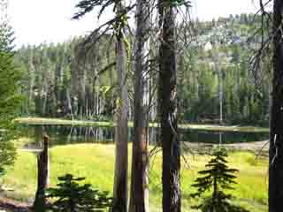 |
 |
||
| Passing close by Shadow Lake, Desolation Wilderness. |
Passing beyond Shadow Lake towards Stony Ridge Lake. |
||
We see Shadow Lake looking Northwest over our Left shoulder as our hike South turns up a slight degree of difficulty, from easy around Lake Genevieve, to an intermediate degree of difficulty once we begin funneling up into the moderate grade ramp hiking past Crag Lake to Stony Ridge Lake. Past Crag Lake we climb onto moderately-inclined ramp of terrain up to the North Shore of Stony Ridge Lake. As we begin climbing this low ramp we come upon Hidden Lake's cutoff to our South, the Southbound hiker's Right, before we climb high enough to get some good looks over our Left shoulder over at Shadow Lake, above.
Less than a half-mile South of Shadow Lake continuing our intermediate difficulty climb we reach the furthest North Shore of the long & narrow Stony Ridge Lake. From the North Shore of Stony Ridge Lake we can see the top end of the canyon we first entered and began ascending hiking out of the Meeks Bay Trailhead. I don't have a picture of this view, but we can make out the line of our route by the lines of the ridges descending from the Sierra Crest and its subordinate ridges around Lake Tahoe.
Hiking out the South end of the canyon kicks our climb kicks up another degree of difficulty. |
|||
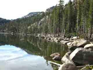
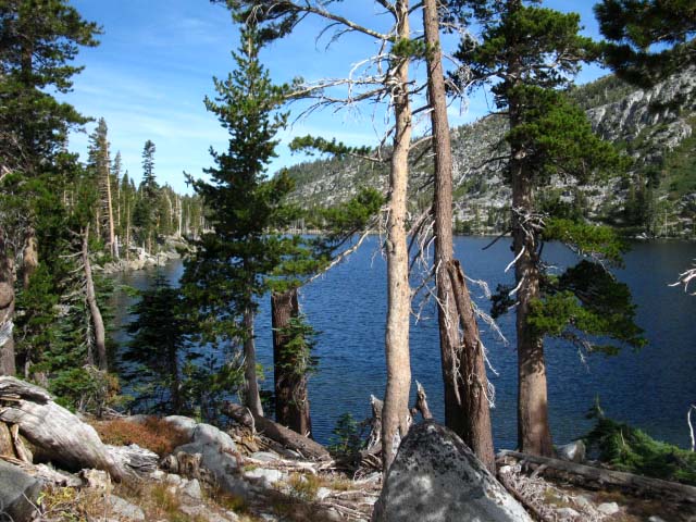
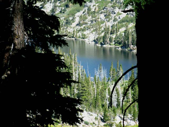
View South Across Stony Ridge Lake
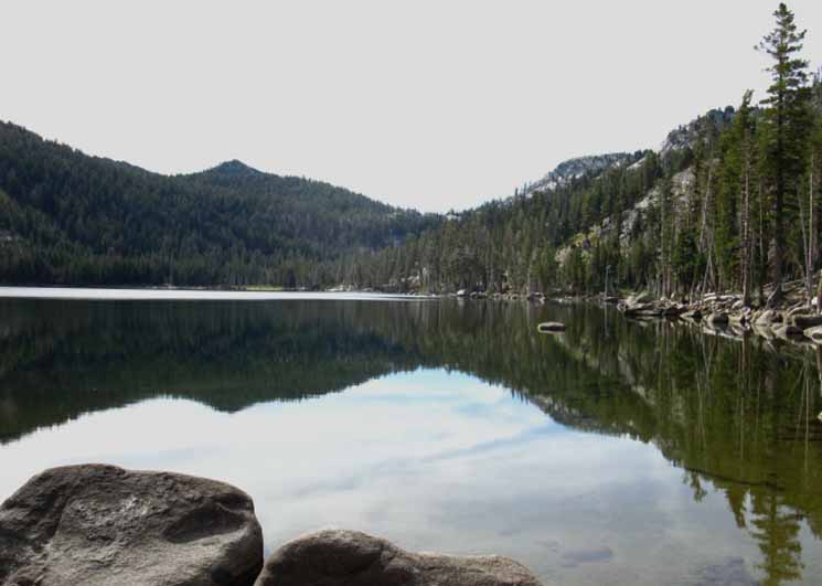
Peak 9519 rises above the Eastern edge of the South Shore of Stony Ridge Lake in the view above from the North Shore of Stony Ridge Lake.
Rubicon Lake sits in the base of the Saddle we see above the South end of Stony Ridge Lake.
Rubicon Peak tops the ridge we see rising to our Left above Stony Ridge Lake, to our Northeast by the compass.
Check out the
Big Top Map of Desolation Wilderness
Click the map for more detailed maps.
Local Temp and Snow Reporting Stations
Click the Big Red Dots.
| Tahoe Basin Weather | All High Sierra Weather |
Video
North Shore
of
Stony Ridge Lake
looking
South
Backpacking Desolation Wilderness to Stony Ridge Lake |
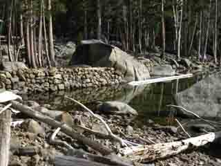
Stony Ridge Lake
Another check dam lake.
More on Check Dam Lakes.
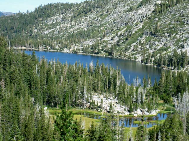
| Northwest shore looking South towards Phipps Peak and Pass |
The massive check dam at Stony Ridge Lake |
||
 The rocky ridgeline comes right down to the West Shore. |
|||
 |
|||
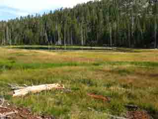
Well Loved Beauty The terrain shows signs of extreme use, the ground compacted, and the wear of the hands and feet of mankind are very apparent, as it is with the majority of the terrain in Desolation Wilderness. The backpacking restrictions and quotas maintain a degree of some kind of balance between naturalness and humanity. |
|||
Video
Al discusses the Trail Head Options Passing by Stony Ridge Lake
It's Stony Ridge Lake! It's one beat Al! |
Check the Forum for more information on our
Trailhead Options
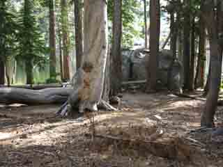
| Stony Ridge Lake Center Campsite | ||
 |
||
About half way between the North and South ends of Stony Ridge Lake we find this very well used campsite area between the trail and the lake.
I like to hike through Desolation Wilderness during the early or late ends of the Summer Backpacking Season. This way we get some degree of the desolation the wilderness was named after. Desolation is much like Yosemite in this respect, in its popularity and traffic. That is a function of its other similarity to Yosemite, that of its profound beauty. These similarities demand we adjust to, and accept that both Desolation Wilderness and Yosemite are places where we are going to be surrounded by people, and not have a bad attitude about all of our fellow backpackers out on these popular trails. We can take solace in the fact that we will soon be far South of this beehive of activity in the Desolation Wilderness, when we depart the Tahoe Basin to pass into the deep isolation of the unmaintained Tahoe to Yosemite Trail through Summit City Canyon. Our "Yin" of busy will get "Yanged" by isolation. We've just gotta have some patience and take our time to carefully enjoy both the social as well as the isolated aspects of this remarkable trail. It's a wide range of experiences that stretch each of us one way or another. |
Video
View from the Middle-South Shore
of
Stony Ridge Lake
Desolation Wilderness
| Rock, forest, and Water. | ||
Hiking to the South end of Stony Ridge Lake. Duration 1:07
|
Backpacking Desolation Wilderness Meeks Bay Backpacking to Stony Ridge Lake
TYT proceeds .58 of a mile along the length of the Southwest shore of Stony Ridge Lake from its North to South shores.
Elevation
Mileage 2.26 miles South to Phipps Pass
|
Backpacking
on the
South Shore
of
Stony Ridge Lake, Desolation Wilderness
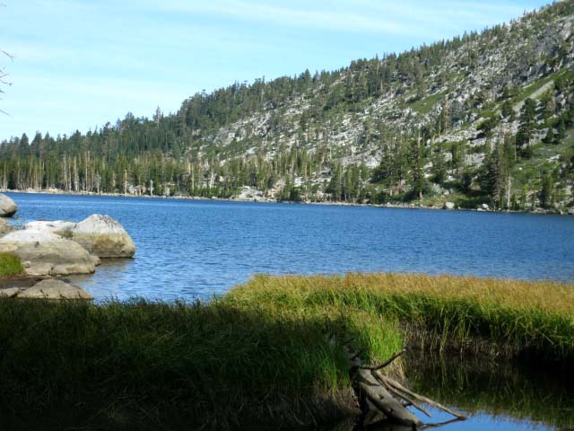
| Looking North along West shore of Stony Ridge Lake. |
 |
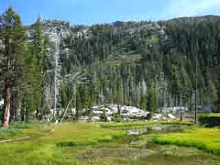
Rocky forested terrain. We can see how the rocky ridges drop right down to the shoreline, leaving little room for trail or campsites along the length of either of its shores. The ridge rising above the far shore is the base of Rubicon Peak. Rubicon Peak has a real-time weather reporting station at the base of its North Flank, from which we can access current and recent temps and snow levels. I've laid out the stations in proximity to Desolation Wilderness on this map. Then we find marshy conditions precluding camping on the South end of Stony Ridge Lake. |
| Hiking South to the South end of Stony Ridge Lake. | ||
 |
||
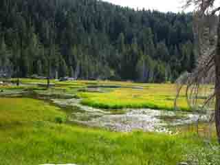
Looking almost directly North across Stony Ridge Lake from its far Southern end. Bits of marsh grasses begin to indicate the boggy conditions deepening above the Southern Shore of Stony Ridge Lake we discover hiking up to the narrowing head of the valley. The drainage off the mountains around the top of the valley appears to drain too quickly for a lake to form, and too slowly to form a well defined creek. Thus the terrain above Stony Ridge Lake is boggy.
|
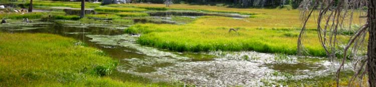
MARSH A most beautiful mosquito factory. Good thing the prevailing winds tend to blow up or across the valley below, or this marsh would keep the valley below alive with mosquitoes.
|
A Marshy Meadow
at the
Head of the Valley
| Delightful meadow-quagmire at the South end of Stony Ridge Lake. The low rolling granite formations appear to extend under the meadow as well as protruding above. This under-girding with granite checks and holds water above Stony Ridge Lake allowing it to fill in with sediments creating a nice marsh-meadow quagmire of Life. |
 |
You and I want to stay the hell out of this beautiful muck and mosquito factory, but it's beautiful to look at, and Heaven for bugs, birds, bears, and even migrating Ducks. Above we are looking North-Northeast, to our Southbound Hiker's Left across the top of the valley just South of Stony Ridge Lake. We are hiking South, to the Right from the perspective above, approaching the steep but short climb up to Rubicon Lake. Rubicon Lake exactly splits the distance up to Phipps Pass from Stony Ridge Lake. |
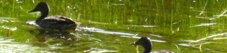
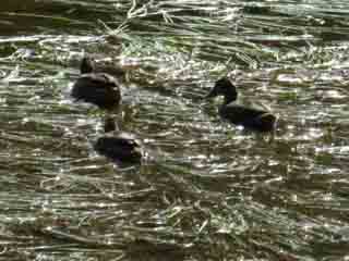
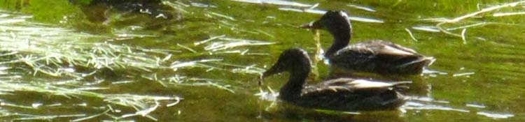
Marshy Meadow Verdant Greens light up the wet marsh and grassy meadow on the South Side of Stony Ridge Lake running up to the head of this narrow wedge of a valley. Movement in the water draws my eye, causing a pause in pace. It's Ducks feeding in the Marsh. Mergansers? Wood Ducks? Looking like Wood Ducks to my layman's eye. They too notice me, and take my measure. The Ducks decide to measure out a bit more distance between us, and move leisurely but deliberately further away from my position. This wet mess above the South Shore of Stony Ridge Lake precludes it as a location for good campsites. Find camping along the drier North and Northwest shores of Stony Ridge Lake. |
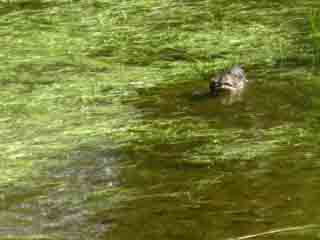
High Sierra Ducks
 |
 |
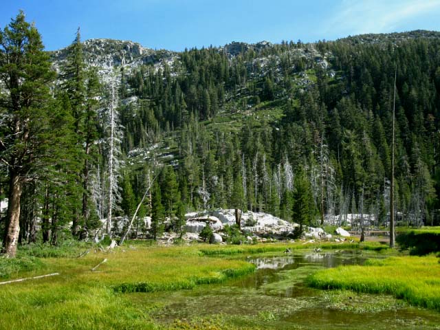
| Verdant green marshy meadow fills up the head of the valley above the North end of Stony Ridge Lake. | Hiking past, I noticed movements in the marshy flow, it's Ducks! |
 |
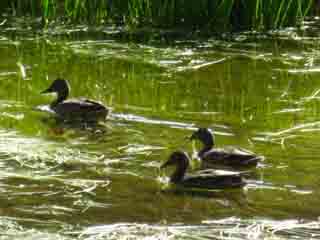 |
| Ducks chilling, but moving away from Al. | I always stop and watch when the ducks are out. Hell, I try to observe everything. |
 |
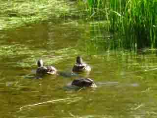 |
Always plan extra time for each day's backpacking so we can stop look at the marsh, watch the Ducks, and everything else that crosses our range of vision along our route. Not just the time necessary to get in and get out, but the time to soak it all up properly. Desolation Wilderness Ducks Forum Entry Feeling Ducky? |
|
Desolation Wilderness
Meeks Bay
|
Into the Heart Our easy hike out of Meeks Bay terminates at the South Side of Stony Ridge Lake. The hike up to Phipps Pass is a brief intermediate-2 difficulty hike. Climbing up to Phipps Pass opens up broad vistas of the Southwestern Shore of Lake Tahoe, and dropping down off the pass brings us into the Heart of the Desolation Wilderness. Middle Velma Lake is another 3.44 miles beyond Phipps Pass, which makes it a total of 5.7 miles to Middle Velma from the South Shore of Stony Ridge Lake. This means that we've 2.26 miles of climbing up to Phipps Pass followed by 3.44 miles of descending trail before we begin the climb up to Dicks Pass from Middle Velma Lake. Middle Velma is the low point of our hike between Phipps and Dicks Pass. |
Nice Trail Work
| Nice use of granite slabs to bridge busy creek across the trail. |
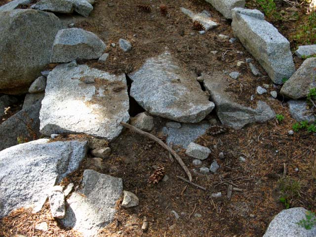 |
Granite Flake Bridge I could see that it took a lot of work to get the rock built-up to the point where these large granite "flakes" would bridge the gap over the creeklet below. Note the extensive build up and backfill of the ramp up to the actual "bridge." The bridge itself is a trio of custom granite slabs. Unique. |
Love My Trail!
| This trail crew feature made me go off trail to get a better look at this pro bit of trail work. |
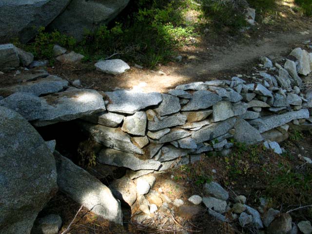 |
Side view of the build-up and cap-stoned bridging off the South Shore of Stony Ridge Lake. NICE. A well planned and executed piece of trail work. A tri-granite block tread for the bridging section is pretty fancy. We are going to keep an eye on the work, the activities, and the locations of trail crew as we hike from Tahoe to Whitney. Report trail crew contacts and observations, as well as examples of their work. Trail Crews and their Work Cool Folk, those Trail Crew COOL to FOOL Now, this evaluation does not necessarily mean that Trail Crew are friendly, though they are always polite, helpful, and safe. It's just that Trail Crew spends their Summers on the trail, and they encounter and meet a lot of backpackers. Trail Crews are also fairly insular. They have their own little community and culture, and can be finicky, only wanting to hang with "trail cool" folks. Other times they are going bat-shit crazy after spending the whole Summer with their own small group. They crave new blood then! Non-Professional trail crews, such as the CCC, and private groups such as SCA run closed camps. The CCC has a training and rehab aspect that requires some discipline and concentration, while SCA seems to be focused on student safety. CCC and SCA are a youth's path to eventual employment on a professional federal trail crew. |
Video
Climbing from Stony Ridge Lake to Phipps Pass
Up the switch backs above Stony Ridge Lake through dense forest littered with great granite boulders. Though not a great piece of film making, we can see and get an idea of the nature of the terrain we climb from Stony Ridge Lake up to Rubicon Lake. |
Views of Stony Ridge Lake
Climbing South
towards
Rubicon Lake
| Climbing South from Stony Ridge Lake. |
 |
We can see how the switchbacks rapidly gain elevation above Stony Ridge Lake. The heavily forested hillside gives good cover from the Sun. |
Stony Ridge Lake
| Climbing South from Stony Ridge Lake we can see the marsh pushing up and around its South shore. |
 |
Looking back to the North while climbing South from Stony Ridge Lake towards Rubicon Lake and on to Phipps Pass. Our trail up to here followed along the Western, or left shore of Stony Ridge Lake from this perspective. We can see the marshy area South of Stony Ridge Lake which fills up the head of the valley. Rubicon Lake is behind us, wedged into its shelf in the mountain ridge we're climbing. |
Backpacking North: Crag Lake Backpacking South: Stony Ridge to Rubicon Lake
Stony Ridge Lake |
||
Departing the Southern End of Stony Ridge Lake Southward presents us with a 2.26 mile hike up 1000 feet to Phipps Pass. Hard-3 or/and Intermediate-1 The trail is nicely switch-backed at a gentle grade. But it presents a stiff climb, even being well graded. The hike between Stony Ridge Lake and Phipps Pass is an intermediate1 or 2 level hike. Harder if we are less fit. The fine forest trails we have traveled on so far will now be decorated with the Great Granite Formations, first rising out of dense forest, which characterize the lower part of the climb up to Phipps Pass. The higher up we go the greater the exposure of the granite features, until we rise to the top of the almost naked granite mountains overlooking the stunning terrain of the Tahoe Basin wrapping around the West and South End of Lake Tahoe. Soon these close-in views of ours, which so far have been beautifully constrained within the forest and rock filled valley hiking up from Meeks Bay will open up much of the Northern Desolation Wilderness for our inspection. comments-questions-experiences?
|
North TYT: Crag Lake South TYT: Stony Ridge to Rubicon Lake
Backpacking |
||
Stony Ridge Lake Backpacking 1.64 miles South past Lake Genevieve we come to the North Shore of Stony Ridge Lake. The Desolation Trail runs for .59 mile along the Western shore of Stony Ridge Lake. Meeks Bay to Dicks Pass While looking at Stony Ridge Lake, and when in Desolation Wilderness generally, I can't help feeling how strange it is that such a remarkable wilderness could exist so close to one of the heaviest-used year-round recreation/resort/vacation areas in California, being Lake Tahoe. Huge population centers bracket the Tahoe Basin, and have been steadily pouring increasing populations into The Basin cities for decades. Added to this are the visitors. This contradiction between the demands of massive populations and the protection of wilderness satisfies neither. Both are going to break... are breaking. Even the system of fees and permit rationing employed during high season cannot mitigate the affects of so many people, of so many backpackers. I'm not complaining about the LTBMU policies or practices. They have done a great job of mitigating impact, within the constraints they face. Though incredibly beautiful, we will not experience any desolation in Desolation Wilderness, especially during the mid-Summer high season. Backpacking through Desolation Wilderness late in the season during the week abates much of the overcrowding Desolation is so well-known for. We can still see the affects of heavy use, even when the people are gone. The extensive compressed flattened areas around the aprons of the lakes and the deep grooves of well-trodden trails are only the most obvious evidence of many unseen hikers. Late and early season backpackers hopefully avoid experiencing Desolation running at capacity. For many backpackers the heavy human presence is reassuring. Desolation Wilderness is a fantastic place for beginning backpackers who still feel a bit uneasy in a wilderness setting to experience an amazing natural environment with the reassuring feeling of having lots of humans nearby while not being "too" far from "civilization." But I'm just stating the obvious reasons why Desolation Wilderness is so busy. Those hikers who want to start their Tahoe to Whitney hike out of a more quiet setting may be inclined to consider using either the Echo Summit or South Upper Truckee Road trail heads to begin backpacking trips. Both are much less traveled during the high season. Yet during late Summer and with the onset of Fall crowds diminish, and Desolation Wilderness gets pretty darn quite. There's still lots of backpackers, but not like Summertime. My take on Desolation Wilderness is that it's good either way, busy or quiet. We are going to have two or three days at a time hiking from Tahoe to Whitney when won't see anyone or talk at all. On the other hand, we're going to hike through Yosemite Valley on our way South to Whitney. This means that we're going to enjoy both the quiet and the busy times hiking down the trail from Tahoe to Whitney, getting our share of each while avoiding neither. Well, we may detour around the Clarks Fork Road (map). No need to experience excessive unnecessary human contact! I meet the best beginning and weekender backpackers while hiking through both Desolation Wilderness and hiking through Yosemite Valley. Weekenders and beginning backpackers congregate in these easily accessible zones of incredible beauty. Along with some amazing experts too. The folks I've met in/around Yosemite Valley are generally backpacking to Little Yosemite on a Half-Dome quest or up to Merced Lake... but, nonetheless, meeting these folks is a real blast. Then there are the John Muir Trail hikers. JMT hikers are a unique group of backpackers. I had cut Desolation and the Yosemite Valley off my routes years ago as the crowds thickened, pushing me South down to starts South out of Echo and Meyers, for some quiet. Then something changed in me. Sometimes it's the lack of people that make the area special, and other times it's the
More
|
| Topo Hiking Map Meeks Bay Trailhead to Dicks Pass |
Topo Hiking Map Lake Genevieve to Phipps Pass |
South
Guide Page
Stony Ridge
to
Rubicon Lake
North TYT: Crag Lake South TYT: Stony Ridge to Rubicon Lake
Backpacking North Trail Guide |
 |
Backpacking South Trail Guide |
Backpacker Forums Post it on Welcome to Tahoe to Whitney
Anyone can post text comments in the existing forums, but only members can post up new topics, along with images, maps, and formatting. As we addressed some gear issues on the page above,
If you have experiences, comments, questions, trip reports, trail conditions updates or pictures and/or videos of the Tahoe to Yosemite Trail from Meeks Bay to Lake Genevieve, and camping around Lake Genevieve and up the valley, post up your images, experiences, notes, and advice here as an unknown hiker or as a member: Post Up! Section
|
North TYT: Crag Lake South TYT: Stony Ridge to Rubicon Lake
Trailhead
Contact
Alex Wierbinski

Backpacking Lake Tahoe to Mount Whitney
Your guide to the High Sierra Crest, including the Tahoe to Yosemite, Pacific Crest, and John Muir Trails
