


General Lake Trail from Lake Genevieve to General Creek
Hiking Map
The Tahoe to Yosemite Trail in the North End of Desolation Wilderness
Four 7.5 minute USGS Backpacking Topo Map of the Desolation Wilderness and Sugar Pine State Park

| INDEX Desolation Wilderness Topo Maps INDEX |
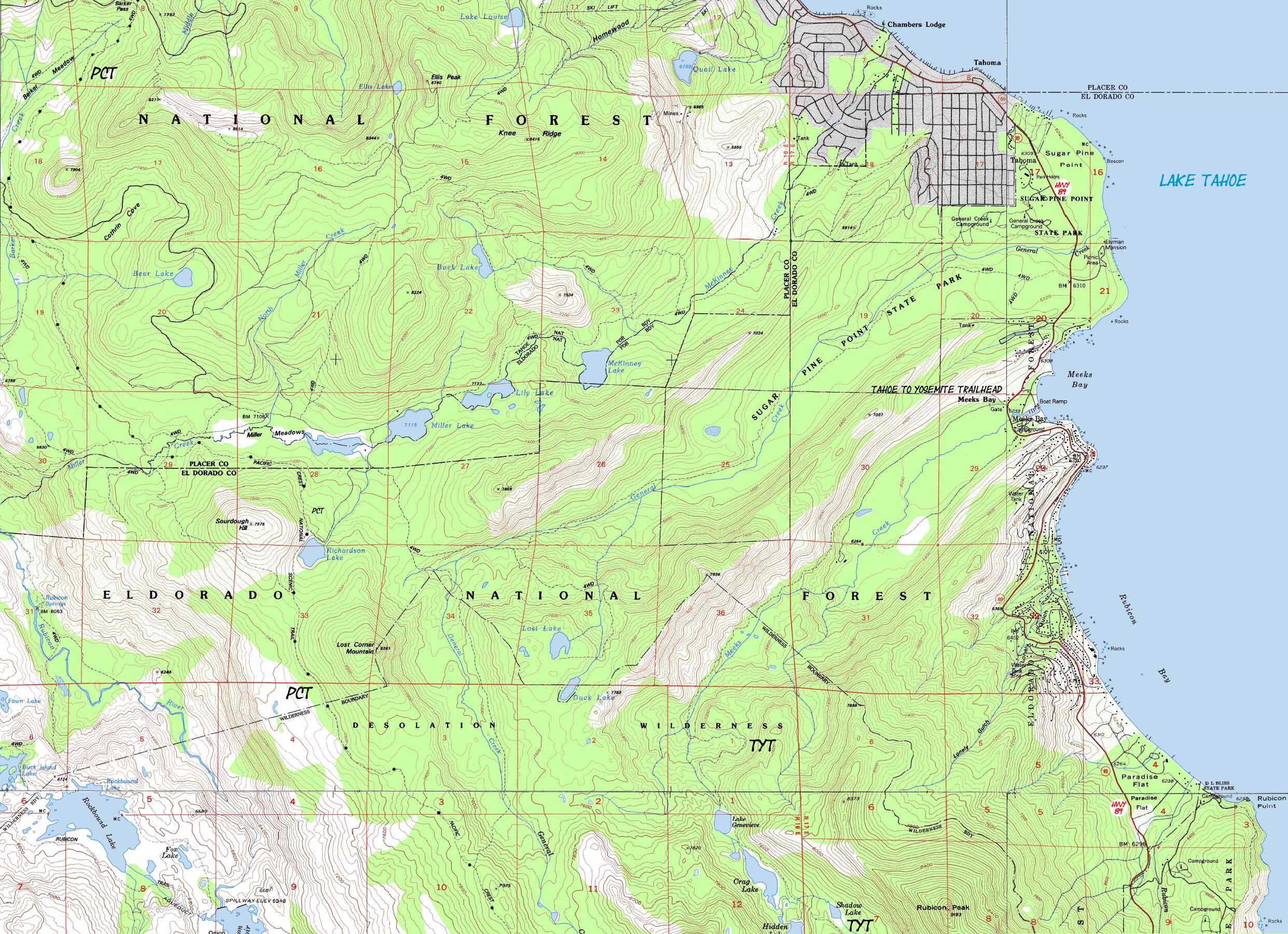
SOUTH TYT 7.5 Topo Map Meeks Bay |
SOUTH 7.5 Topo Map Phipps Pass to Susie Lake |
SOUTH 30 min Map Phipps Pass to Lake Aloha |
Miles and Elevations |
Trail Guide Meeks Bay Trailhead |
North Desolation Wilderness Backpacking Map
and
Sugar Pine State Park
Mileage and Elevations No Links on this Map
| South 7.5 min map Meeks Bay Trailhead |
30 min MAP Lake Genevieve to Middle Velma Lake |
South 7.5 min map Phipps Pass to Susie Lake |
|
| South 7.5 min map Meeks Bay TYT Trailhead |
30 min MAP Lake Genevieve to Middle Velma Lake |
South 7.5 min map Phipps Pass to Susie Lake |
| Road and Trailhead access to South Lake Tahoe |
||||
| Three Excellent Representative Trailheads Highways 50 and 89 Meeks Bay, Echo Summit and South Upper Truckee Trailheads |
South Lake Tahoe Resources Highways 50 & 89 |
|||
|
See
|
|||
MAP NOTE What's important for our general reference purpose is that each side of a square is 1000 meters, or a Kilometer. From my point of view that is 1093 yards or .62 of a mile. Diagonal: 1414.22 meters, if my trig is correct. That converts into 4,639.8 feet or .88 of a mile.
|
Desolation Wilderness |
|||||
Meeks Bay to Phipps PassHiking to Phipps Pass: +2561 feet, 8.88 miles Location Elevation Mileage Meeks Bay 6239 0 Lake Genevieve 7400 4.39 Crag Lake 7440 4.77 Hidden Lake Jnct 7560 5.35 N. side, Stony Ridge Lake 7800 6.03 S. side, Stony Ridge Lake 7800 6.62 Rubicon Lake 8360 7.75 Grouse Lake Jnct 8400 7.89 Grouse Lake Jnct 2 8800 8.73 Phipps Pass 8800 8.88Meeks Bay to Echo Summit
|
|||||
| Map Information | Common Map Symbols |
| Online and Trail Maps | Online Length Conversion |
USGS Topo Hiking Maps
NW Map: Homewood, California, 7.5 Quadrangle, 1992
SW Map: Rockbound Valley California, 7.5 Quadrangle, 1992
NE Map: Meeks Bay, California-NV, 7.5 Quadrangle, 1992
SE Map: Emerald Bay, California-NV, 7.5 Quadrangle, 1992
Compass Offset
Magnetic North is 15 1/2 degrees East of True North
scale
1:24 000
Contours
40 Feet
Backpacking permitting authority
The
"LTBMU"
or the
Lake Tahoe Basin Management Unit
The Lake Tahoe Basin Management Unit is the federal agency administering all the National Forest, Wilderness, and special areas within the area that drains into Lake Tahoe.
Trail Guide Information
Lake Tahoe Basin Management Unit for Backpackers
The feds
Lake Tahoe Basin Management Unit
National Forest
The LTBMU was constructed out of elements of the surrounding National Forests.
Desolation Wilderness Area
Information and Permits
The Feds:
Desolation Wilderness
Physical location:
North of Meeks Bay Trailhead along Highway 89
Trail Guide:
Tahoe to Alpine
Index
Trail head
Meeks Bay Trailhead
North 7.5 min map: Meeks Bay South 7.5 min map: Phipps Pass to Susie Lake
| Elevations | More Desolation Wilderness Information | |
Meeks Bay Lake Genevieve Phipps Pass |
Trail Guide, Section Trail Guide first page Google Map |
|
USGS Map Credit |
U.S. Geological Survey, Department of the Interior The Get the full topo at theUSGS Topographic Map Information * * *Download Free USGS Topo MapsINSTRUCTIONS 1>Locate the position you need a map for on the google map. 2>CLICK the MARK POINTS mode. 3>Select the size of MAP FOOTPRINTS you wish to see. 4>CLICK the Map Footprint you want to down load. This will leave a red marker on that map footprint. 5>CLICK the red marker, and the maps available for you to download will appear. 6>Select and download the map you need. NOTE: These are "GEO Maps" that load in Adobe Reader with many cool functions. If you want to manipulate and print custom sections, you must first load the map into MS Paint before it can be manipulated in PhotoShop. |
The Tahoe to Yosemite Trail begins at the
Meeks Bay Trailhead