Four Trails Connect
the
TYT and PCT
across the
Carson Iceberg Wilderness
The Highland Creek Trail is the Northernmost
and a
Classic Trail
These four trails connecting the TYT and PCT across the Carson Iceberg Wilderness provide exceptional Carson Iceberg Wilderness Backpacking Loops and Alternative Routes of Varying Distances to the Main PCT & TYT routes.
Four trails
Carson-Iceberg Wilderness Backpacking Loops
using the
PCT and TYT
Unique Routes Each
As with their respective routes across the Mokelumne Wilderness to our North, the Pacific Crest and Tahoe to Yosemite Trails continue to explore completely different routes across the Carson Iceberg Wilderness to our South.
But unlike the Mokelumne Wilderness, where no series of trails connect the PCT and TYT routes, four trails connect the PCT and TYT routes across the length of the Carson Iceberg Wilderness.
These are the Highland, Arnot, Disaster, and Boulder Creek Trails.
High and Low Trails
As in the Mokelumne Wilderness to our North, the Pacific Crest Trail hiker crossing Ebbetts Pass Southbound will stay (mostly) on the Eastern flank and follow the Sierra Nevada Crestline to Sonora Pass, while the Southbound Tahoe to Yosemite Trail hiker crossing Highway 4 at Lake Alpine backpacks much lower down along the Western flank of the Sierra until we make the big climb over Saint Mary Pass to the Saint Marys Pass Trailhead on Highway 108 near Sonora Pass.
TYT Back to the Sierra Crest
At the South end of the Carson Iceberg Wilderness TYT hikers will watch the trail transition into an unmaintained trail as we climb alongside the Clarks Fork of the Stanislaus River.
At the top of the unmaintained trail on the stunningly beautiful North edge of Clarks Meadow we depart our sweet campsite to route-find our way South
up an untrailed route and out of the headwaters bowl of the Clarks Fork River over Saint Marys Pass.
We pick up maintained trail down
to the TYT-Saint Marys Pass Trailhead on Highway 108, which lays very close to the Sierra Crestline just a short distance West of Sonora Pass.
Local Backpacking Loops around the Carson Iceberg Wilderness
Hiking either the PCT or TYT South across the length of the Carson-Iceberg Wilderness we find four convenient trails linking the Tahoe to Yosemite Trail with the Pacific Crest Trail.
These trails allow local backpackers to craft loops of various diameters staying within the Carson Iceberg Wilderness using sections of both the Tahoe to Yosemite and Pacific Crest Trails. North to South these trails are Highland Creek, Arnot Creek, Disaster Creek, and Boulder Creek.
We can begin backpacking loops from trailheads around the Carson Iceberg Wilderness. Highway 4, the Clarks Fork Road off Highway 108, and the high trailheads at Sonora Pass on Highway 108 are all potential excellent starting points for great and small backpacking loops around the Carson Iceberg Wilderness.
Check out the Carson Iceberg Wilderness Hiking Map, consult the mileage pages for the TYT and PCT routes across the Wilderness linked to above to figure out the Carson Iceberg Wilderness hiking loop that's perfect for you.
Alternative Routes to the TYT,
Longer routes than the PCT
There are three basic reasons to hike alternative routes to the standard TYT and PCT routes across the Carson Iceberg Wilderness. For TYT hikers the main reason given is to detour around the unmaintained segment of trail between Eureka Valley and Saint Marys Pass. The second reason would be to detour around the lengthy segment of trail along the busy Clarks Fork Road.
The final reason is to expand the length of our hike and the number of things we see as we backpack between Lake Tahoe to Mount Whitney. We can both avoid the Clarks Fork Road and hike through the untrailed South end of the Carson Iceberg on the TYT.
We would hike up Highland Creek off the TYT and back to the TYT via Boulder Lake to achieve this maximal route.
Highland Creek Hybrid
The Highland Creek Hybrid is one of my favorite routes through the Carson Iceberg Wilderness heading Southbound along the Tahoe to Yosemite Trail.
At the Jenkins Canyon trail junction we depart the Tahoe to Yosemite Trail to continue hiking up Highland Creek past its source at the West Highland Lake, past the East Highland Lake and the car campground nestled between the lakes to the Gardiner Meadows trailhead.
From Gardiner Meadows we have but a short hike to join up with the Pacific Crest Trail at Wolf Creek Pass. Past Gardiner Meadow Trailhead we encounter the trail junction where the Arnot and Disaster Creek trails coming up from the Tahoe to Yosemite Trail route along Clarks Fork Road tie into our trail to the PCT.
This is where the North end of both the Arnot and Disaster Creek trails link up with the trail between Gardiner Meadow and the PCT.
If we had continued South along the Tahoe to Yosemite Trail from Jenkins Canyon, and turned North to link up with the PCT through either the Arnot or Disaster Creek trails, this junction is where we would end up. That's three trails to the same place!
Why Switch Trails?
We are looking for the best of both the TYT and PC trails, and moving our route through the segments of trail that most appeal to our tastes. To our North the choices we faced hiking through the Mokelumne Wilderness were stark: either we hike the TYT thorough beautiful granite gorge holding Summit City Creek and the North fork of the Mokelumne River with its section of unmaintained trail, or we hike the stark volcanic flanks of the East Sierra on well maintained trails.
Since I prefer magnificent granite gorges to stark volcanic flanks I generally hike the TYT route through the unmaintained trail section from Carson Pass to Lake Alpine.
South of Lake Alpine in the Carson Iceberg Wilderness one of my favorite sections of terrain is the East fork of the Carson River, which lays along the route of the Pacific Crest Trail. But I am standing at Lake Alpine along the Tahoe to Yosemite Trail.
My only question is "which of the four connector trails will I hike over to the PCT, and which one back?"
Well, the way back to the TYT is almost always the Boulder Lake Trail in the very Southern end of the Carson Iceberg Wilderness...
My Favorite is Highland Creek
Switching trails allows us to hike through the rigors, isolation, and beauty of the Tahoe to Yosemite Trail route through Summit City Creek in the Mokelumne Wilderness on our way South from Carson Pass to resupply at the Lake Alpine Lodge along the Tahoe to Yosemite Trail route.
From Lake Alpine we'll continue South along the Tahoe to Yosemite Trail route to the Jenkins Canyon trail junction before turning Northeast off the Tahoe to Yosemite Trail towards the Pacific Crest Trail.
TYT up Highland Creek to PCT at Wolf Creek Pass
Backpacking Map
At the Jenkins Canyon TYT trail junction we continue NE following Highland Creek through the top of Highland Canyon and past the Highland Lakes to link up with the Pacific Crest Trail at Wolf Creek Pass. Or, we have the option of continuing South on the TYT up Jenkins Canyon.
There are three more trails South of Highland Creek along the TYT that link up with the PCT as we cross the length of the Western Carson Iceberg.
Central and South Carson Iceberg Wilderness
Backpacking Map
If we Southbound hikers return to the TYT through the fourth and Southernmost of the connector trails, the Boulder Lake Trail, the Southbound TYT soon deteriorates from maintained trail into an unmaintained route, and finally climbs into and through what can only be called a "route through the terrain," rather than a conventional trail, or even an "unmaintained" trail.
The TYT South from Clarks Meadow (and maybe even further North, lower down) is a route, not a trail. From Clarks Fork Meadow we must self-navigate ourselves to Saint Marys Pass independent of trailbed, ducks, or blazes.
It's not quite scrambling, because there is a route through the terrain, but its not normal backpacking because there is not any discernable trail or trailbed.
It is pretty frkn cool, if you are into that sort of thing.
There are a few "wild ducks" marking the route around Clarks Meadow, but not many. Explore the maps, miles and elevations, and trail guide pages to inform yourself about these routes.
Here's the Key Trail Guide Page...
Lots to See Here
My point is that we have lots of route options hiking across the Carson Iceberg Wilderness. The first time I hiked the whole Tahoe to Whitney trip in 1998 I found great joy in finding, and sewing together the most interesting sections of trail possible, and I have continued this approach to the present.
Carson Iceberg Wilderness Map
Click Red and Black Dots for more information
Great alternatives to the standard Tahoe to Yosemite and Pacific Crest Trail routes continue and even expand when we cross Highway 108 into the next wilderness to our South, the Emigrant Wilderness. We have three basic routes across the Emigrant Wilderness to the Yosemite boundary. These routes' deep interconnections allow a fantastic range of backpacking loops around the splendors of the Emigrant Wilderness for short and medium distance backpackers. Like the Carson Iceberg Wilderness to its North, we can easily put together 90 mile loops around the High Altitude sections of the Emigrant Wilderness.
Whooo-Hoooo!
My annual backpacking cycle in the Carson Iceberg is a Winter trip or two accessing the Sierra through Rodriguez Flat North of Walker on Hwy 395 or up Highway 108 West of the Marine Base. Spring brings the annual attempt to reach Sonora Pass via the unmaintained E Carson River trail, which is also one of my early season conditions scouting trip. Then come the Summer Trips, which generally involve exploring some trail variation connecting together the PCT and TYT as I hike South to Tuolumne Meadows.
That's when life is working properly...
I have a couple of more discussions about our backpacking trip loop options around the Carson Iceberg Wilderness at the Jenkins Canyon Trail Junction and the Boulder Creek Trail Junction.
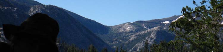
Highway 4 on the East Shore of Lake Alpine
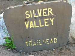
Silver Valley Trailhead
The sign above was at the Silver Valley Trailhead before it was removed. Though a classic trailhead sign, both in color and form, yet both the trailheads and the route have changed significantly over the years.
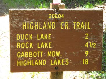
Gabbott Meadow was drowned by the creation of Spicer Meadow Reservoir in 1989. Gabbot Meadow now sits under the East side of the reservoir, though surrounded by lakeside campsites. The Jenkins Canyon trail junction at 11.58 miles South down the combined TYT-Highland Creek Trail is where the TYT turns Southwest and the Highland Creek Trail continues up Highland Canyon to Highland Lakes.
Wolf Creek Pass is 3.27 miles NE from the Highland Lakes Trailhead at the top of Highland Canyon. This puts the distance from the Silver Valley Trailhead along the TYT to Wolf Creek Pass on the PCT at 21.27 miles.
I have this distance measured out at 21.11 miles on my miles and elevations list.
Yet the mileages on this sign above, as well as figures from all sources including me, are suspect due to intervening years full of trail route modifications since the routes were laid out and measured. But the mileages on this sign are close, so I vote they should have left this sign up.
My General Approach to High Sierra Miles Figures
Wolf Creek Pass is 9.73 miles NE up Highland Canyon from the Jenkins Canyon trail junction where the TYT route continues South.
Wolf Creek Pass is about 7 miles South of Ebbetts Pass and 22.48 miles North of Sonora Pass on the Pacific Crest Trail.
Thus we can hike from the Silver Trailhead via the Highland Creek Trail to Wolf Creek Pass and then North on the PCT to Ebbetts Pass over 28.27 miles.
Top of Page |