


South Desolation Wilderness Hiking Topo Map
The Tahoe to Yosemite, Pacific Crest, and Tahoe Rim Trails
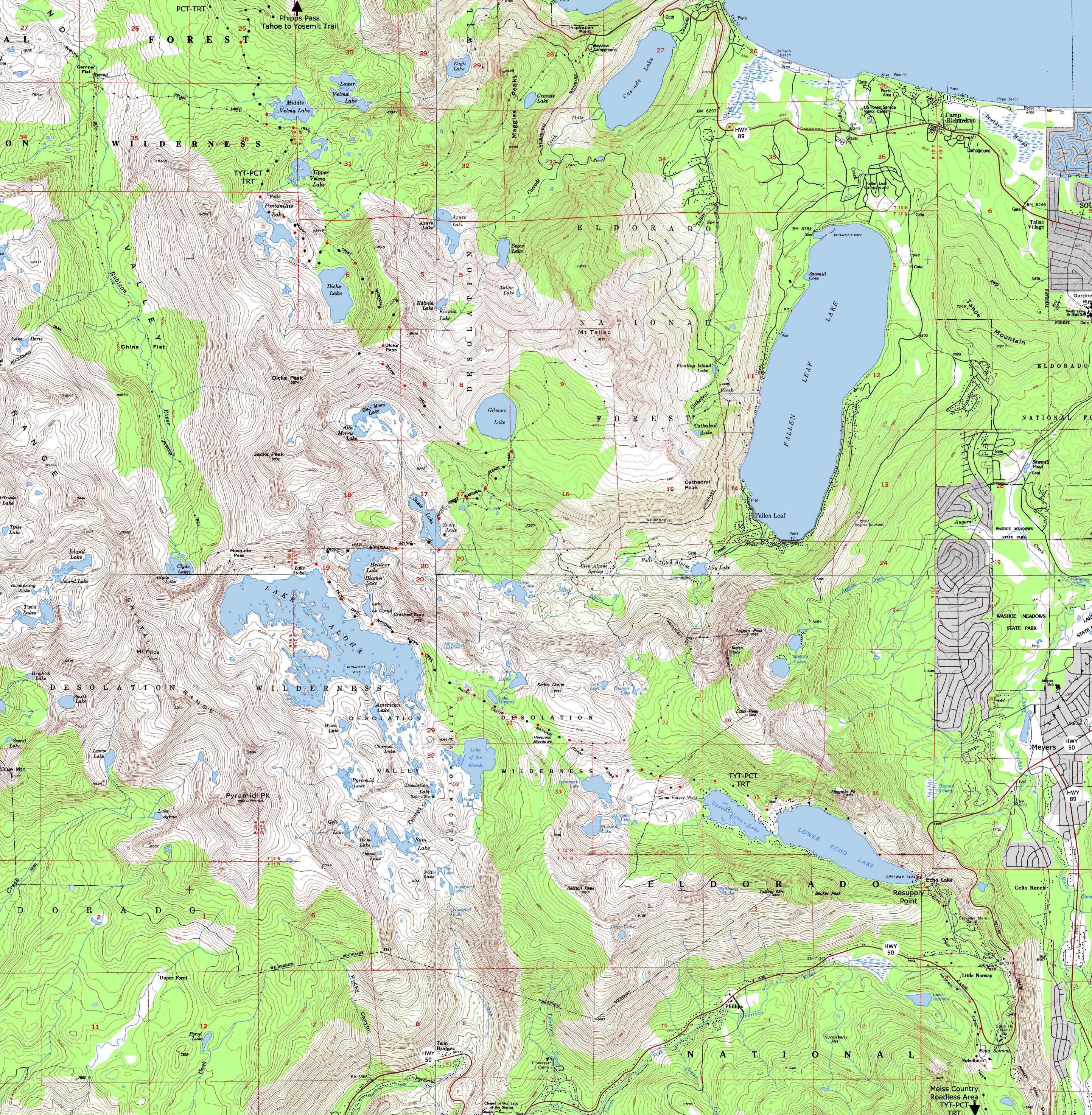
4 USGS 7.5 minute backpacking topo maps of the Southern Desolation Wilderness
Maps Index |
Guide Index |
7.5 min |
7.5 min TYT-PCT Meiss |
Miles Meeks |
Miles |
Trail Guide PAGE |
30 minute |
Click |
WEATHER |
RESUPPLY |
PERMITS |
|
Backpacking Southern Desolation Wilderness
Dicks Pass to Echo Lake Trailhead
11.88 miles
| North 7.5 minute topo hiking map Meeks Bay to Dicks Pass |
South 7.5 minute topo hiking map Echo Lake to Echo Summit |
Further South 7.5 topo hiking map Echo Summit to Carson Pass |
|
| North 7.5 minute topo hiking map Meeks Bay to Dicks Pass |
South 7.5 minute topo hiking map Echo Lake to Echo Summit |
Further South 7.5 topo hiking map Echo Summit to Carson Pass |
Location |
|||||
Main Features: This is the Southernmost of three overlapping topo map compliations covering the Tahoe to Yosemite and Pacific Crest Trails through Desolation Wilderness. North Desolation Wilderness Central Desolation Wilderness South Desolation Wilderness These three maps overlap so we can follow side trails to local trailheads off of the main TYT-PCT route through Desolation Wilderness, such as Eagle Falls, Bayview Camp, and Cascade Lake along the West shore of Lake Tahoe. On the other side of the mountain we have Rockbound Valley. The point of these maps is not just to guide you down the long trails, but to draw you out into the beauties of Nature, first to explore short trips and loops into the Desolation Wilderness, then to spend some time stretching out your legs, lungs, and spirit on the long trails. These trailheads along the West shore of Lake Tahoe offer short, if steep hikes into the heart of the Desolation Wilderness, and give us many options for hiking trips between trailheads, if not loops returning to our start point. My hidden goal is to subtly push you towards hiking the whole 28.71 mile length of the Desolation Wilderness as the first section of your section-by-section hike down to Tuolumne Meadows if not Mount Whitney. This type of on the trail preparation and experience is vitally important for those of us considering hiking the Pacific Crest Trail or even the Tahoe to Yosemite and John Muir Trails. Every year I meet strong young people on the trail who have not given themselves the training or experience to effectively deploy or maintain their strength. They suffer needlessly. The very success or failure of their efforts becomes dependent upon how well they recover from their lack of physical preparation, gearing errors, and a wide range of unfounded assumptions about nature and how their body will work in nature. This transformational experience can be very dangerous. It can end all your experience, if not torture you, if you are not properly prepared. A few short trips to work out the gear, break in the boots, figure out your food, and get the legs woken-up will save endless problems on the long trail. If you only learn by doing things the hard way, be my guest. If you're feeling froggy, jump, by all means!
|
| Road and Trailhead access to South Lake Tahoe |
||||
| Three Excellent Representative Trailheads Highways 50 and 89 Meeks Bay, Echo Summit and South Upper Truckee Trailheads |
South Lake Tahoe Resources Highways 50 & 89 |
|||
More
|
||||
Miles, Elevations, |
|
Mileages Backpacking Dicks Pass down to Susie Lake Desolation Wilderness -1590, 2.93 miles Topo Map: Phipps Pass to Lake AlohaDicks Pass 9390 16.83 -1090 1.33 Gilmore Lake Jnct 8300 18.16 -180 .59 Hlf Moon/Gln Alpine Jnct 8120 18.75 -240 .30 Glen Alpine Jnct 2 7880 19.05 -80 .31 E. side Susie Lake 7800 19.36 -- .40 W. side Susie Lake 7800 19.76
Susie Lake to the North side of Lake Aloha Topo Map: Phipps Pass to Lake Aloha+320 feet, 1.4 miles W. side Susie Lake 7800 19.76 +120 .56 W. side Heather Lake 7920 20.32 +200 .84 N. Lake Aloha/Rubicon Jnct 8120 21.16
North side of Lake Aloha to Echo Summit End of the Desolation Wilderness Topo Map: Aloha LakeMap: Upper Echo Lake Map: Lower Echo Lake- 706 feet, 9.55 miles N. Lake Aloha/Rubicon Jnct 8120 21.16 +40 1.42 Lake of the Woods Jnct 8160 22.58 -80 .59 Lake Lucille/ Margery Jnct, (L) and Lake of the Woods (R) 8080 23.17 +240 .41 Lake Lucille/ Margery Jnct, #2 (L), and Lake of the Woods #4 (R) 8320 23.58 -80 .76 Triangle/Lilly Lakes Jnct 8240 24.34 -360 .68 Tamarack Lake Jnct 7880 25.02 -80 .46 Triangle/Lilly 2nd Jnct 7800 25.48 -280 .61 Boat Taxi Dock 7520 26.09 -106 2.62 Echo Lake Trail Head 7414 28.71 |
The map above is composed of four USGS 7.5 minute Topographic maps, clockwise from upper Left: Northwest Map Northeast Map Southeast Map Southwest Map Compass Offset
Scale Contours
Backpacking Permitting Authority Lake Tahoe Basin Management Unit Lake Tahoe Basin Management Unit
National Forest LTBMU
Wilderness Area: Desolation Wilderness, TahoeWhitney Desolation Wilderness, the feds.
Physical location: Desolation Wilderness Region Map
Tahoe to Alpine Trail Guide Index Meeks Bay trail head
|
| Top of Page | |
Map North: Meeks Bay to Dicks Pass Map South: Echo Lake trailhead to Round Top Lake
| Elevations | More Information | ||
Lake Tahoe Dicks Pass North Side of Lake Aloha Lower Echo Lake Trailhead |
Trail Guide, Section Trail Guide, Segment Google Road Map |
||
Map Credit |
U.S. Geological Survey, Department of the Interior: The Use search term "Meeks Bay," and "Address," as search type to locate this USGS map. USGS Topographic |
This trail guide began at the
Meeks Bay Trailhead