High Sierra
Backpacking
Trail Guide
Forums
Sierra
Weather
Gear
The Stanislaus National Forest
Information for
Long and Short Distance
High Sierra Backpacking
especially
Tahoe to Yosemite Trail Backpackers
Languages
Trail Skills
Mountain
Safety
Safety
Incidents
Food
Planning
40 Days to Whitney Introduction Tahoe-Yosemite
Trail Arts
More
Information
News
and
Science
Social
| National Forests & Parks INDEX |
Lake Tahoe PERMITS |
El Dorado NF |
Stanislaus NF |
Humboldt - Toiyabe NF |
Yosemite Permits |
PCT or TYT? |
National Forest PERMITS |
National Forests map |
contacts |
| Sequoia-Kings Canyon National Park |
Mountain Safety Issues
Inciweb
Stanislaus National Forest
The Stanislaus National Forest Index |
||
Backpacking
Scope
Wilderness
Section & Loop
South
|
Highway 4 Corridor
Highway 108 Corridor
|
Stanislaus National Forest links
Stanislaus National Forest
Stanislaus National Forest
Big Picture Map
Permit |
Beauties and Benefits of the Stanislaus National Forest I've always met real nice folks in their Ranger Stations and over the phone. There's no fees and no reservation system. And, I'd say that the Emigrant Wilderness of the Stanislaus Forest is the very best way to hike Yosemite, if you don't hike a big-assed loop around this amazing and special place. Hiking to Tuolumne Meadows in Yosemite on the TYT route out of the Emigrant Wilderness in the Stanislaus National Forest is ideal backpacking. But let's not get out of balance, as the Stanislaus National Forest administers amazing terrain in the Mokelumne, Carson Iceberg, and Emigrant Wilderness along the West flank of the Sierra Crest. Our Tahoe to Yosemite Trail route brings us through the best of it. > Forum < |
||
STANISLAUS NATIONAL FOREST |
||
Stanislaus National ForestMain Office19777 Greenley Road (Highway 108) (209) 532-3671
Classic National Forest Stanislaus NF Stanislaus NF Stanislaus NF Trailheads Stanislaus NF Stanislaus NF All Contact Information located on Left Sidebar of I've never stopped into or called the main office. I will at some point, and I expect they have the same attitude I find in all the hiker-based National Forest contacts. |
Highway 4 CorridorCALAVERAS
|
Highway 108 CorridorSUMMIT
|
Stanislaus National Forest Emigrant, Carson Iceberg, and Mokelumne Wilderness Areas The Key Points |
||
Wilderness Permits
Trips entering Yosemite National Park Wilderness from Cherry Lake, Kibbie Ridge, or Lake Eleanor, visit any district office or call the Groveland Ranger District by phone no more than 24 hours in advance of your trip. Only 25 people may obtain a Wilderness Permit to Kibbie Ridge/Lake, but due to damage from the RIM fire only 10 people may obtain a permit to Lake Eleanor per day in these areas per National Park quotes. These free permits are required year-round. Bear canisters are required and dogs, even on leash, are not allowed on trails. All Yosemite National Park wilderness regulations apply. |
Group Size Limits
Campfires Campsite Location |
Length of Stay
Sanitation
Trails |
Wilderness Areas of the Stanislaus National Forest FEDERAL INFORMATION PAGES |
||
National Forest
and
Trail Guide
Website Links
Stanislaus National ForestHiking Resources and Information Tahoe to Yosemite Trail
|
|||
Introduction The Stanislaus National Forest extends from just a bit North of Highway 4, the Ebbetts Pass Road, South to wrap its Southern end around the Northwestern and Western boundaries of Yosemite National Park. While almost the entirety of the Pacific Crest Trail South of the Tahoe Basin is within the Toiyabe National Forest, so too is the entirety of the Tahoe to Yosemite Trail between Highway 4 and the Yosemite Boundary is within the Stanislaus National Forest. From Camp Irene to our Bond Pass entrance into Yosemite National Park our Tahoe to Yosemite Trail route hikes through the Western side of these three Wilderness Areas administered by the Stanislaus National Forest. Find below a tremendous amount of information about the Stanislaus National Forest. |
|||
Stanislaus National Forest |
|||
|
Carson Pass on Highway 88 to Mount Reba just North of Lake Alpine on Highway 4 TYT Route See El Dorado NF for TYT route across Northwestern Mokelumne Wilderness and the Toiyabe NF for the route of PCT across the Eastern Mokelumne Wilderness. |
Lake Alpine on Highway 4 to Saint Marys Pass on Highway 108 TYT Route Toiyabe NF administers route of PCT across Eastern Carson Iceberg Wilderness.. |
South of Saint Marys and Sonora Passes on Highway 108 to the Yosemite National Park: The TYT and PCT routes. TYT and PCT Routes Toiyabe NF administers route of PCT East of the Emigrant Wilderness.. |
|
| Mokelumne Wilderness | Carson Iceberg Wilderness | Emigrant Wilderness |
|
El Dorado National Forest North and Western Mokelumne Wilderness
Amador Ranger District Highway 88 Access Trail
Federal Website links El Dorado NF
Tahoe to Whitney Trail Guide Index TW local map TW local map
|
Stanislaus National Forest Southeast Mokelumne Wilderness
Calavaras Ranger District Highway 4 Access Trail
Federal Website links Stanislaus NF Stanislaus NF Hiking Map Hiking Map
Tahoe to Whitney Stanislaus National Forest Trail Guide Index TW local map TW local map
|
Stanislaus National Forest Western Carson Iceberg Wilderness
Calavaras Ranger District Highway 4 Access Trail South side of the Carson-Iceberg Wilderness Summit Ranger District Highway 108 Access NORTH Federal Website links Stanislaus NF Carson-Iceberg Wilderness Information Hiking Map Miles Map Miles Page
Tahoe to Whitney Stanislaus National Forest Trail Guide Index TW local map TW regional map |
Stanislaus National Forest All Emigrant Wilderness
Summit Ranger District Highway 108 Access Trails
Federal Website links Stanislaus NF Stanislaus NF Hiking Map Hiking Map Miles Map
Tahoe to Whitney Stanislaus National Forest Trail Guide Index TW topo hiking map TW topo hiking map |
| TW regional map Mokelumne Wilderness Backpacking Map |
|||
TW Trail Guide Resources |
|||
| TW Trail Guide Resources Maps |
|||
Mokelumne Wilderness TW region map TW region map
|
Carson Iceberg Wilderness TW region Map TW region Map TW region Map
Highway 4 |
Emigrant Wilderness TW region Map TW region Map
Highway 108 |
|
National Forest & Trail Guide
Maps, Miles, and Elevations
| Maps & Miles on the Stanislaus National Forest website |
Maps, Miles, and Elevations on the Tahoe to Yosemite Trail |
National Forest Maps NF Topo Hiking Map NF Topo Hiking Map
National Forest Miles Stanislaus NF Miles Map Stanislaus NF Miles Map Stanislaus NF Miles
Good Hiking Maps Stanislaus NF Topo Hiking Map Stanislaus NF Topo Hiking Map |
Tahoe to Whitney TYT TYT-PCT
Tahoe to Whitney TYT TYT Paper Maps Online |
To obtain a permit you have two, maybe three options, First, you can stop at the Ranger Station during working hours and fill out a permit. Second, if you cannot pick up your permit, you can call the proper Ranger Station prior to your trip, and the Rangers will fill out your permit and leave it outside for you to pick up. Third, if you find it impossible to stop in at the Ranger Station on your way to your trail head, you can sometimes talk the Ranger into filling out your permit and sending it to you. They don't like to do this anymore, as the Ranger Stations are running real short of money. As I often hitch-hike to trailheads, it is much easier for me if I call the Ranger Station well in advance of my departure date and talk them into sending me the permit. A great thing about the Stanislaus National Forest is that there are no permit restrictions or crazy reservation system. It's easy to get permits from every Ranger Station of all three wilderness areas covered by the Stanislaus National Forest. |
The Stanislaus National Forest
The Tahoe to Yosemite Trail routeBackpacking
|
Hiking the Length of the Stanislaus National Forest
The Scope The Tahoe to Yosemite Trail hikes across the long length of the Stanislaus National Forest. We entered the Stanislaus National Forest far from any trail head where we crossed the North Fork of the Mokelumne River at Camp Irene. Tahoe to Yosemite Trail hikers will also exit the Stanislaus National Forest far from any trailhead, 68 miles (?) South of Camp Irene where we depart Emigrant Wilderness hiking through Bond Pass into Yosemite National Park. During these 68 miles we crossed the Western sections of the Mokelumne and Carson Iceberg Wilderness, and hiked across the heart of the Emigrant Wilderness. We have crossed both Highway 4 at Lake Alpine and 108 at Sonora Pass before exiting the Stanislaus National Forest deep in the High Sierra Backcountry where we enter the Yosemite Wilderness. As I said, the Tahoe to Yosemite Trail route enters and departs the Stanislaus National Forest far from any trailheads. We enter the Calavaras Ranger District of the Stanislaus National Forest at Camp Irene after hiking 16.45 miles South from the Carson Gap out of the Lake Tahoe Basin into the Mokelumne Wilderness administered by the Amador Ranger District of the El Dorado National Forest. Our trailhead selection stretches out or shortens hikes through the Stanislaus National Forest. We will pull our permit from whichever Ranger District covers our beginning trailhead. That will authorize us to travel through all subsequent Wilderness, Forests, and Parks to the destination specified on the permit.
Wilderness Areas Scope of the Stanislaus The Stanislaus National Forest is large, but not as large as the Toiyabe National Forest. Toiyabe for the PCT Wrapping Northeast Yosemite Big View West Slope-Stanislaus Admin What is the Hoover Wilderness? East Slope South of Yosemite WEST SLOPE The Western Route Carson Iceberg Wilderness Backpacking Loops and Trips I strongly urge you to check out the Western sections of all three of these amazing wilderness areas. Once you get a idea of how large and diverse these areas are, you will see my logic in always planning trips of no less than five days. Eastern Aspects The PCT route down the length Eastern Sierra between Lake Tahoe and Yosemite is predominantly within the Toiyabe National Forest. The Toiyabe NF offers access to the same wilderness areas, but from a much different perspective than the TYT, along the Eastern escarpment of the Sierra Nevada rather than the Western flank. The Eastern sections of both the Mokelumne and Carson Iceberg Wilderness sit within the Toiyabe National Forest. The terrain on the Eastern and Western Flanks of the Sierra are considerably different. Between Carson Pass and Sonora Pass the PCT passes mostly through Volcanic terrain within the Toiyabe National Forest, with the notable exception of the upper reaches of the East Fork of the Carson River. Lovely place. The Western Route of the Tahoe to Yosemite brings us across terrain that defines the interfaces between granite and volcanic terrains. Just delicious. To access the amazing High Sierra Hiking trails within the Stanislaus National Forest for short or medium distance backpacking trips you should divide the Stanislaus National Forest by Highway Access. Highway 4 and Highway 108 are the main highways that access the wilderness areas and the high trails across the length of the Stanislaus National Forest, and these highways bracket the Stanislaus National Forest's wilderness areas. Highway 4 offers access into the Southern Mokelumne and Northern Carson Iceberg Wilderness while Highway 108 accesses the Southern Carson Iceberg and Northern Emigrant Wilderness. |
Section Hikers
Section Hiking the Western Sierra across the Stanislaus National Forest Got a few days you need to kill? Have I got some trips through the Stanislaus for you! From Lake Alpine on Highway 4 you can section hike the Tahoe to Yosemite Trail North into the Mokelumne Wilderness to Carson Pass, a hard 20 mile trip. Or you can section hike the 34.64 miles of the Tahoe to Yosemite Trail South from Lake Alpine into the Carson Iceberg Wilderness down to Saint Marys Pass on Highway 108. From Highway 108 the 75 mile hike South down to Tuolumne Meadows beckons. Topo Maps of the Stanislaus National Forest Wilderness Areas for Long, Short, and Looping Hikers Carson Pass to Lake Alpine: The TYT, El Dorado to Stanislaus NFs, Mokelumne Wilderness. (Click the red dots along the TYT route for that location's trail guide page.) Lake Alpine to Saint Marys Pass: The TYT, Stanislaus NF, Carson Iceberg Wilderness. (Click the red dots along the TYT route for that location's trail guide page.) Saint Marys Pass to Yosemite Boundary: The TYT, Stanislaus NF, Emigrant Wilderness. (Neither are the trail routes or the red dots yet laid out, though I've labeled some of the features in the Emigrant Wilderness. Check out this map of the PCT South of Sonora Pass that depicts the Heart of the High Emigrant Basin. You can see where the TYT comes up from Kennedy Meadows and the difference between the PCT and TYT routes South of Sonora Pass. I prefer to craft my own routes through here, depending on how I'm feeling and what I want to see.) From Highway 108 you can hike North into the Carson Iceberg Wilderness towards Ebbetts Pass or Lake Alpine, or hike South into the Emigrant Wilderness towards Tuolumne Meadows or Hetch Hetchy in Yosemite National Park. |
The Most Fun TYT-PCT LOOPS and Section Hiking the TYT from Carson Pass to Tuolumne Meadows in Yosemite You can hike loops to and from your selected trailheads along the PCT or TYT on both Highway 4 and Highway 108. The plan is to hike out on the PCT and loop back on the TYT, or visa-versa. You can craft some pretty amazing PCT-TYT loops South from Highway 4, and North and South from Highway 108. These are great loops, a whole lot of fun. Twenty seven miles is around the very minimum distance you can make a TYT-PCT loop around the Carson Iceberg and Emigrant Wilderness, and you can easily stretch these loops out to 80 or 90 miles. Easily. Here's how you do it: locate your favorite PCT or TYT trailheads along Highways 4 or 108. Look at both trails going South from Highway 4, and North or South from Highway 108. Note the first connector trail between the trails. Figure out the mileage. Note the second connector between the trails. Figure out that mileage. What suites you? The Emigrant Wilderness makes up the North and Northwestern boundary of Yosemite National Park, making the Stanislaus Trailheads along Highway 108 a great way to hike into and across Yosemite when permits are in very short supply at Tuolumne Meadows in Yosemite during mid-Summer. Section Hiking If you are section-hiking the Tahoe to Yosemite Trail Southbound between Carson Pass on Highway 88 and Lake Alpine on Highway 4 you will obtain your permit from the Amador Ranger District of the El Dorado National Forest. Carson Pass to Lake Alpine The Carson Pass itself is administered by a special zone, the Carson Pass Management Area. The CPMA itself is also administered by the El Dorado National Forest, through the Amador Ranger District. Contact the Amador Ranger District for information on the CPMA and hiking South on the Tahoe to Yosemite Trail from Carson Pass. Lake Alpine to Carson Pass If you are section-hiking the TYT Northbound between Lake Alpine on Highway 4 to Carson Pass on Highway 88 or South to Highway 108, you will obtain your permit from the Calavaras Ranger District of the Stanislaus National Forest. (see above) North and South from Highway 108 Draw your permit from the Summit Ranger District of the Stanislaus National Forest if you are hiking North or South out of the Western Highway 108 corridor. (see above) I say the Western Corridors of Highways 4 and 108 because the the Eastern sides of both Highways 4 and 108 are within and administered by the Carson and Bridgeport Ranger Districts of the Toiyabe National Forest, respectively. The Sierra Crestline acts as the rough dividing line between the Toiyabe National Forest on the Eastern side of the Sierra Nevada between Lake Tahoe and Yosemite, while the El Dorado and Stanislaus National Forests administer the Western flank of the Sierra between Lake Tahoe to the Northwestern Yosemite National Park boundary. Got it? If not, or if I got it wrong, add you information or hit me up through the comments link below. |
South out of the Lake Tahoe Basin on the Tahoe to Yosemite Though we exited the Lake Tahoe Basin Management Unit when we crossed out of the natural confines of the Lake Tahoe Basin through the Carson Gap, the Sierra crestline running North and South through Carson Pass on Highway 88 is the de-facto boundary dividing the Toiyabe National Forest's territory on the Eastern side of the Sierra crest line against the El Dorado's administration of the Western flank. The tiny Carson Pass Management Area that surrounds the Carson Pass itself is administered by the Amador Ranger District of the El Dorado National Forest. This is our Southbound gateway into either the Stanislaus National Forest if we hike Southwest on the TYT, or the Toiyabe National Forest if we hike Southeast on the PCT. Hiking Southwest through the El Dorado National Forest along Summit City Creek we will cross into the Stanislaus National Forest when we ford the North Fork of the Mokelumne River in the hushed splendor emanating from the green forest and granite isolation around "serene" Camp Irene. Man, I love that place. Tahoe to Yosemite Trail Route The Stanislaus National Forest Administers more of the Tahoe to Yosemite Trail route than any other permitting authority along the TYT. Overall, the Stanislaus National Forest administers the Tahoe to Yosemite Trail from 8.36 miles North of Lake Alpine at the North Fork of the Mokelumne River at Camp Irene all the way down to Yosemite National Park boundary at Bond Pass. I have the length of the Tahoe to Yosemite Trail through the Stanislaus National Forest at somewhere around 62 miles of the route's 181 total miles, roughly a third of our total distance. The length of the TYT that the Stanislaus administers can be broken into three stand-alone hiking trips. The basic divisions are Carson Pass to Lake Alpine through the Mokelumne Wilderness, Lake Alpine to Saint Marys Pass through the Carson-Iceberg Wilderness, and Kennedy Meadows to Tuolumne Meadows through the Emigrant Wilderness and the North Yosemite backcountry. |
Too long? Too Hard? Too Easy? Pick the Section that suits you, Cut it Down, or Add these Sections Up! Create the perfect trip for You The Stanislaus National Forest offers a wide range of short and medium distance hiking trips that give backpackers deep access to three High Sierra wilderness areas with hundreds of miles of classic Sierra hiking trails. Well, not a whole lot of the Pacific Crest Trail, unless you put your mind, and your feet towards making that happen. Most the the Pacific Crest Trail and its part of these three wilderness areas are within the Toiyabe National Forest on the East side of the Sierra Crest. But this presents no problem at all. We can easily hike sections along the PCT out of the Stanislaus NF by crafting trips either through the Carson Iceberg or Emigrant Wilderness where we link up the PCT and TYT through their connector trails. I have laid these options out on the Carson Iceberg Wilderness Map. Check out the Highway 4 to Highway 108 trail guide index. |
NORTH and SOUTHBOUND PCT HIKERS Hikers on the Pacific Crest Trail will see little of the Stanislaus National Forest. Unless you exercise some of these same route options, and weave-in elements of the Tahoe to Yosemite Trail into your PCT hike through these same connector trails mentioned above and in the trail guide. Two strong suggestions for hikers North and South on either trail: do your homework, compose your route by putting together the best sections of both trails by finding the sections that best suit you, your goals, your experience, and your level of fitness. Or first hike the classic routes of each trail, then start weaving them together. This hiking will be as interesting as you make it. The Pacific Crest Trail route Vs. The Tahoe to Yosemite Trail route across the Northern Sierra Nevada The Pacific Crest Trail backpacker will merely brush the Stanislaus National Forest a couple of times hiking along the Sierra Crestline between Carson Pass and Sonora Pass. The majority of the PCT hiker's trail between Carson Pass and Yosemite Lays within the Toiyabe National Forest. Once you cross Highway 108 at the Sonora Pass (Southbound) you will enter the Stanislaus National forest for your brief hike around the Eastern edge of the Emigrant Wilderness for 7.97 miles. Once you pass South over the Leavitt Massif the PCT turns East to again hike into the Toiyabe National Forest at Kennedy Canyon and remains in the Toiyabe NF until we enter the Northern Boundary of the Yosemite National Park's wilderness through Dorothy Lake Pass. The total length of the Pacific Crest Trail hiker's involvement with the Stanislaus NF is limited to these very few steps. That's too bad, as the Stanislaus has a lot of beautiful terrain that PCT hikers miss. The annual traffic is heavy when the "main body" of PCT hikers pass through the Sierra Nevada, and I'm glad it goes around the heart of the Emigrant Wilderness. On the other hand, the Tahoe to Yosemite Trail hiker is within the Stanislaus National Forest for the majority of their hike between Carson Pass and Yosemite. The TYT route is much quieter... And Visa-Versa... On the third hand, the Tahoe to Yosemite backpacker is deprived of the experience of hiking through the Toiyabe National Forest, especially the East Fork of the Carson River. The Southbound Tahoe to Yosemite hiker will not see the Toiyabe National Forest again after entering Summit City Creek. (The TYT hiker can see the Toiyabe from Carson Pass, and from the South side of Round Top... ) In short, the PCT hiker only gets a taste of the Stanislaus NF, and the TYT hiker only gets a couple of brief glances East at the Toiyabe NF. The Tahoe to Yosemite and Pacific Crest Trails each craft unique routes down the Sierra Crest. The PCT is biased to the East flank of the Sierra Nevada, and the TYT biased to the Western flank. This makes hiking between Lake Tahoe and Tuolumne Meadows something that needs to be done at least four times, once to check out each route, and a second time to get to know them a little better, a third trip to put together the best parts of both trails, and a fourth trip just for fun, to fully deploy your knowledge and explore the relationships between these two classic High Sierra Hiking Routes.
Pacific Crest Trail Route: MODIFICATIONS for the ADVENTUROUS PCT-TYT HIKER Pacific Crest Trail hikers (Northbound) can incorporate greater experience in the Stanislaus National Forest into their hikes. Especially PCT section hikers, who generally take more time, take more scrambles, and take more side-routes. Taking more time, or should I say investing more time exploring the terrain has its advantages. PCT alternative Route #1: Across the Emigrant Basin to Kennedy Meadows Pack Station First, your exit and re supply strategy from Yosemite National Park. You are going to resupply at Kennedy Meadows Pack Station, being your first resupply located 75 miles North of Tuolumne Meadows. The PCT exits Yosemite through Dorothy Lake Pass, swings down to the West Walker River drainage, then turns up Kennedy Canyon to the backside of Leavitt Peak. Sonora Pass and Highway 108 sit on the North side of Leavitt Peak. You can easily hike down to Kennedy Meadows Pack Station by entering the Emigrant Wilderness of the Stanislaus National forest through Bond Pass rather than exiting Yosemite into the Toiyabe National Forest through Dorothy Lake Pass. Here's how you do it: Rather than passing out of Yosemite National Park through Dorothy Lake Pass into the Toiyabe National Forest on your way North to Sonora Pass, you instead turn Northwest through Bond Pass into Emigrant Wilderness, then hike down the TYT route to pick up your re supply at Kennedy Meadows Pack Station, rather than hitch-hike from Sonora Pass. The trail junction up to Bond Pass sits about a mile South of Dorothy Lake Pass at the top of Jack Main Canyon. Most Pacific Crest Trail hikers hitch-hike down Highway 108 to Kennedy Meadows from Sonora Pass. I merely propose walking there by the Tahoe to Yosemite Trail route... From Kennedy Meadows you can easily hitch back up to Sonora Pass on Highway 108 and continue South on the Pacific Crest Trail from there. This route variation adds around 15 miles to your total. I've got to check that... but it's a great piece of trail and stunning country that the PCT misses. The alternative route for the Southbound Tahoe to Yosemite hiker is to exit Saint Marys Pass and walk the mile East up to Sonora Pass. From Sonora Pass we can continue our hike South on the Pacific Crest Trail. Or we can hitch down to Kennedy Meadows, resupply, and follow the TYT route South out of Kennedy Meadows to our Bond Pass entry into Yosemite where we will rejoin with the PCT route for the majority of the remaining hike down to Tuolumne Meadows. Contrast and Compare Route Variations Is it worth it? It's quite a bit longer to hike down to Kennedy Meadows Pack Station along the TYT than hiking to Sonora Pass along the PCT and hitch hiking down to KM. Lake Harriet, just North of Dorothy Lake along the Pacific Crest Trail is real pretty, set in thin Whitebark forest and granite. The terrain down the West Walker is fine forest and granite too, and the trail into Kennedy Canyon has a very remote feel to it. We have a lot of hiking options around the Emigrant Wilderness that are quite nice options on a long distance hiking trip or can be put together to form a nice long local hiking loop. Hiking the Tahoe to Yosemite Trail route North or South through Bond Pass brings us into and across the heart of the High Emigrant Wilderness. Continuing Northwest we have grand views of the multiplicity of canyons falling West off the Sierra Crest line, until we pass into the great granite bowl that composes the High Emigrant Basin making up the high heart of the Emigrant Wilderness. Trails radiate out from the High Emigrant Basin to all major compass points. To the North a trail crosses over Big Sam to intersect with the PCT at the top of Kennedy Canyon. To the Southwest trails lead down the Western flank of the Sierra towards Pinecrest Lake far down mountain near Highway 108. To the Northwest the Tahoe to Yosemite Trail passes through the interface between granite and volcanic terrain that Brown Bear Pass perfectly splits on its way down to Kennedy Meadows. On the NE side of the Emigrant Wilderness its granite terrain has been covered by volcanic material, revealing a stunning line where these ancient volcanic eruptions reached the limit of their flows. The SW side of Brown Bear Pass is composed of the distinctive pinkish-hued granite that highlights the beauty of the the High Emigrant Basin. Hiking up to the throat of Brown Bear Pass we see that the interface between granite and volcanic terrain continues down the middle of the valley on the Northwest side of Brown Bear Pass. Majestic granite bounds the SW side of the valley, while volcanic formations decorate the NE side. As you head down Summit Creek between this terrain created by fire and ice the incredible bulk of Granite Chief rises out of the terrain, like a great island of granite surrounded by an ancient sea of frozen lava. Quite Beautiful. As you can infer from my route descriptions, I think both the Pacific Crest and Tahoe to Yosemite routes on the North side of Yosemite National Park are awesome. You can't lose by hiking either route. My theory is to put together the longest trip your senses and physical capability can reasonably absorb. PCT Northbound alternative Route #2: Extending the Route through the Carson Iceberg Wilderness by tying together elements of the Pacific Crest and Tahoe to Yosemite Trails My second way-cool alternative route is to cut off of the Pacific Crest Trail route at Wolf Creek Pass in the Carson Iceberg Wilderness to hike down to an optional PCT resupply, and a mandatory big fresh meal at Lake Alpine Lodge via Highland Creek and the Tahoe to Yosemite Trail route. Map. From Lake Alpine we can either remain on the TYT hiking North to Carson Pass to experience the deep solitude and route-finding difficulty of the unmaintained trail from Camp Irene North through Summit City Creek to Round Top. This is a very different set of trail conditions and atmosphere than hiking on the Pacific Crest Trail. Besides requiring route-finding skills and the ability to deal with deep isolation, this route variation adds about 11 miles to your total. Contrast and Compare Route Variations What is really different about this unmaintained section of the TYT from Lake Alpine to Carson Pass from the Pacific Crest Trail from Ebbetts Pass to Carson Pass is the pace. You can only go as fast as you are able to find a route through the terrain. You cannot just put your head down and hike as fast as you can. That approach will get you lost. The TYT route requires a different approach to hiking than the PCT. I strongly suggest hiking the Highland Creek connector to the TYT from Wolf Creek while hiking North on the PCT in the Carson Iceberg Wilderness, and visa-versa if you are hiking South on the TYT. I strongly suggest that you break off from the TYT to connect up with the PCT at Wolf Creek Pass if you are hiking the TYT Southbound out of Lake Alpine. This route variation allows the TYT hiker to see the upper reaches of the East Fork of the Carson River. A fine section of the East Carson River is encased deep within a grand granite vault that is just stunning from the Pacific Crest Trail. As you will arrive at Sonora Pass on the PCT route only a mile East of the TYT's access point on Highway 108 at Saint Marys Pass, you will have substantially the same hitch-hike down to Kennedy Meadows to rejoin the the Tahoe to Yosemite Trail route Southbound to Yosemite. Southbound hikers on the PCT will miss the hike up and over Tyron Peak, the cow-pie water of Noble Lake, and the volcanic terrain and forest that composes Noble Canyon's Eastward drainage. The view from the shoulder of Tyron Peak is really nice. From that position you can see how the Highland, Arnot, and Disaster Creek Drainages carve the terrain dropping off the Western Flank from the Sierra Nevada Crest line. In return the PCT hiker will be rewarded by the seclusion of the hike down Highland Creek, the great granite terrain along lower Highland Creek, close-up views of the great volcanic mass of The Dardanelles, and the satisfaction of walking into Lake Alpine. At Lake Alpine you are in position to hike through the unmaintained section of trail along the TYT up to your reunion with the PCT at Carson Pass. Or we can hitch 15 miles East from Lake Alpine up Highway 4 to continue our hike along the PCT from Ebbetts Pass. Hiking the Lake Alpine to Carson Pass section of the TYT is much more of a navigational challenge than the Pacific Crest Trail between Ebbetts Pass and Carson Pass. The terrain is very much different as well. While the PCT passes through almost exclusively volcanic terrain, the TYT leaves volcanic terrain behind after crossing over Mount Reba. Climbing into Summit City Creek's great granite canyon is exhilarating. PCT section hikers should seriously consider these two route variations, the first across the Emigrant Wilderness to walk into Kennedy Meadows from the North Yosemite Backcountry, as well as our second option of hiking down to Lake Alpine from the Northern Carson Iceberg Wilderness. Overall These route options mixing up the best sections of the Tahoe to Yosemite and Pacific Crest Trail as you hike through the Stanislaus National Forest will add a few dozen miles, and give you a good taste of the Stanislaus National Forest if you are a Pacific Crest Trail hiker. I suggest the Highland Creek connector to for hikers on both the TYT and the PCT. This extension of the trip through the Carson Iceberg Wilderness makes both routes richer. If the PCT hiker does not alter their route they will miss the joys of the Stanislaus National Forest. If the TYT hiker does not alter their route they will miss the East Carson River in the Toiyabe National Forest. Yeah, I know you PCTers are in a rush. Too bad for you. The trails between Lake Tahoe and Mount Whitney are the Crown Jewel of the Pacific Crest Trail. If you can't stretch out the most beautiful part of the whole trip a bit, then that means that you've got to come on back and do it again in a manner that will allow you to actually "soak it up," and take the time to do the experience justice. |
|
High Sierra National Forests, Parks, and Wilderness Areas
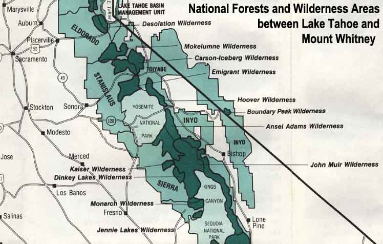 |
| Map Credit: Forest Service, Pacific Southwest Region, "A Guide to National Forest Wilderness in California." |
Our guide to the Sierra Crest, including the Tahoe to Yosemite, the Pacific Crest and the John Muir Trails