


Sonora Pass to Bensen Lake
Backpacking Map
of the
Pacific Crest Trail
Emigrant Wilderness
backpacking
into the
North Yosemite Backcountry
The
Tahoe to Yosemite Trail
intersects with the
Pacific Crest Trail
below
Bond Pass
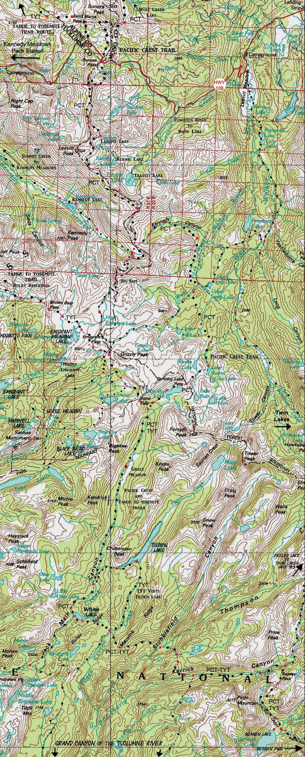
30 minute USGS Backpacking Topo Map of Emigrant Wilderness, Toiyabe National Forest and the Yosemite National Park

| PCT MAPS and MILEAGES |
DETAILED TOPO HIKING MAPS |
Tahoe to Whitney TRAIL GUIDE INDEXES |
MILES and ELEVATIONS |
7.5 Map |
Permits, Resupply, Weather and Map Information |
|||||||||||||||||
| PCT Sonora Pass to Tuolumne Meadows HIKING MAP INDEX |
30 Min MAP NORTH Ebbetts Pass to Sonora Pass |
30 Min MAP SOUTH Bensen Lake to Virginia Canyon |
MILES |
Carson Iceberg Wilderness Map North of Sonora Pass |
PCT MAP SOUTH Sonora Pass Map |
TYT MAP SOUTH Kennedy Meadows Map |
All MILES Tahoe to Whitney |
TYT SECTION MAPS Sonora Pass to Tuolumne Meadows |
All MAPS Tahoe to Whitney |
PCT NORTH Ebbetts Pass to Sonora Pass |
PCT SOUTH Sonora Pass to Tuolumne Meadows |
Sonora Pass over Leavitt Peak |
TWO WAYS from Leavitt Peak to Yosemite |
PERMITS |
Resupply Points Kennedy Meadows -- Tuolumne Meadows |
Weather |
||||||
FULLY
LINKED
TOPO HIKING MAP
Click the Map
RED DOTS
Trail Guide Pages
&
BLACK DOTS
Detailed Maps
| North PCT Ebbetts Pass to Sonora Pass |
PCT & TYT North and South across Highway 108 Sonora Pass Region Trails |
South PCT-TYT Bensen Lake to Virginia Canyon |
|
| North PCT-TYT Ebbetts Pass to Sonora Pass |
PCT & TYT North and South across Highway 108: |
South PCT-TYT Bensen Lake to Virginia Canyon |
|
| Sonora Pass Region Trails Backpacking Map |
Further South Grand Canyon of the Tuolumne River Backpacking Map |
||
| Mapology | ||||
MAP NOTE What's important for our general reference purpose is that each side of a square is 1000 meters, or a Kilometer. From my point of view that is 1093.6 yards or .62 of a mile. Diagonal That converts the diagonal distance into 4,639.8 feet or .88 of a mile.
|
North Sierra Trailhead Roadmap
|
Tuolumne Meadows Roadmap
|
| Location Information | |||
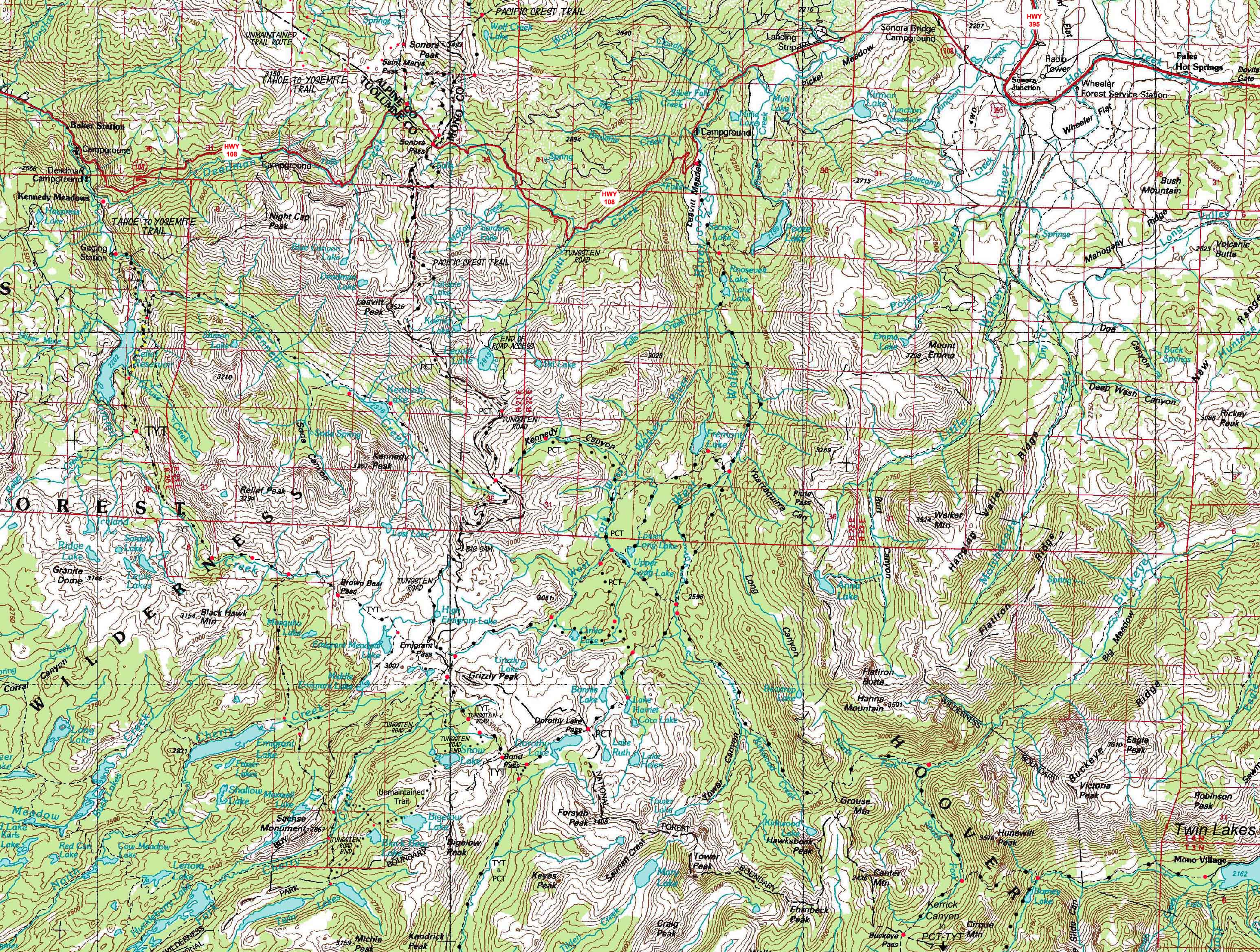
Main Features Southbound backpackers on the Pacific Crest Trail exit the Carson-Iceberg Wilderness just North of the Sonora Pass, and enter the Emigrant Wilderness by walking across to the South side of Highway 108. Click the Carson-Iceberg Label on the map above to see the Carson Iceberg Wilderness topo hiking map to the North of Highway 108. The Sonora Pass Shortcut From the trailhead we have two immediate options: Straight up the shortcut along the descending Northwestern ridgearm off the Leavitt Massif above Sonora Pass, or winding around the big traverse up the North flank of the Leavitt Massif along the regular PCT route. Latopie Lake Loop Rather than rejoining the Pacific Crest Trail by climbing back up the way we came down to Latopie Lake, we can wind our way around the mountain shoulder bounding Latopie Lake to the South, into a gentle drainage leading us back up through an ancient valley of glacially broken and compressed rocks to the PCT at the gap overlooking Kennedy Lake. Kennedy Canyon Trail Junction This is our first four-way trail junction along the Sierra Crestline. It's located 8 miles South of Sonora Pass. Here the Pacific Crest Trail turns East down Kennedy Canyon. Though this drainage is a beautiful route that will take us down to, and then back up the West West Walker River into the Cascade Creek drainage up to our entrance into Yosemite National Park through Dorthy Lake Pass (all this section of the East Flank drains into the West Walker and exits the mountains via Leavitt Meadow below), this is not my preferred route. Tungsten Road to Grizzly Peak In the middle of Emigrant Basin we encounter the second four-way trail junction along the Sierra Crest at Grizzly Peak, this one being 14.14 miles South of Sonora Pass. End of the Tungsten Road PCT & TYT Entering Jack Main Canyon brings us downriver through forest and meadow along Falls Creek, all bound within the grandure of Jack Main Canyon's magnificant glacial cut granite. Oh, and the mountains along the Northwest wall of Jack Main's upper canyon are of an intriguing mixture of minerals... tungsten? Besides my Emigrant Basin shortcut to the TYT at Grizzly Peak off the Pacific Crest Trail's route around the heart of the Emigrant Wilderness on the PCT's way through its West Walker River and the Dorthy Lake Pass entry into Yosemite. I reccomend that we explore all of our route options South of Highway 108 over a number of long PCT & TYT trips across the Emigrant Wilderness, complimented by long backpacking loop trips into the Emigrant Wilderness and its adjacent slot of the Toiyabe National Forest (the West Walker Watershed) for its own sake.
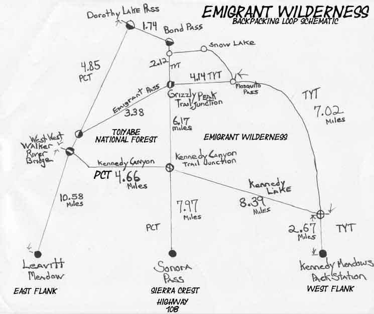
Check out the Sonora Pass Region Trails in context of the schematic above. Short Routes in this area The main trailheads along the Highway 108 corridor are att Kennedy Meadows Pack Station on the Western Flank, Sonora Pass along the Sierra Crestline, and Leavitt Lake and Leavitt Meadow on the Eastern Flank. From Highway 108 on the West flank or the Sierra Crest we can hike to Tuolumne on the Classic PCT or TYT Routes. 75 to 84 miles, respectively. Or we can turn loops through the Kennedy Canyon or Grizzly Peak trail junctions from any of these three Highway 108 Trailheads decorating the Sierra Crest and its East and West flanks. Our options are endless We have what appears to be endless trip options hiking South from the Sonora Pass corridor. There is an infinity of natural beauty to explore within these constrained wilderness boundaries.
The Last Tahoe to Yosemite route option Jack Main Canyon to Stubblefield Canyon Map The Tilden Lake junction offers us a choice: Take the Tahoe to Yosemite Trail around Tilden Lake, and miss Wilmer Lake, or take the Pacific Crest Trail and miss Tilden Lake. Independent of which route you take, both routes rejoin at the first junction South of both lakes.
The End or a New Beginning? Into the Central Sierra Nevada Trails The Best of All Worlds Tahoe to Yosemite Hikers come up from Kennedy Meadows Pack Station through Brown Bear Pass into the beauties of the High Emigrant Basin, a wonderful place. My custom PCT route variation continues straight over Big Sam into the High Emigrant Basin, rather than following the PCT around The High Emigrant Basin, or the Tahoe to Yosemite up from Kennedy Meadows. Northbound PCT Option: Northbound PCT hikers are in the "catbird" seat, so to speak. The Northbound PCT hiker can cross the heart of the Emigrant Wilderness rather than hike around it if they choose to walk in to pick up their resupply at Kennedy Meadows Pack Station rather than hitch-hiking there from Sonora Pass. Here's how you do it: Turn Northwest to hike through Bond Pass rather than continuing South out of Yosemite through Dorothy Lake Pass at the top of Jack Main Canyon. Continue NW past the Snow Lake and the Horse Meadow trail junctions in Summit Meadow to the Grizzly Peak trail junction at the Southwest base of Grizzly Peak. Here you intersect with the TYT, which turns Northwest to hike through Brown Bear Pass down Summit Creek to Kennedy Meadows. This is a fantastic alternative route that brings you through the heart of the terrain here, which is otherwise hidden to the masses of passing PCTers, THANK GOD! You should check it out... |
FULLY LINKED
LARGE SCALE RAW MAP
Scroll
East and West
of
Sonora Pass
Click the Map
for more
DETAILED MAPS
CLICK FOR UNDERLAYING MAPS
Sonora Pass Region Backpacking Map
|
| North PCT-TYT Ebbetts Pass to Sonora Pass |
PCT & TYT North and South across Highway 108: |
South PCT-TYT Bensen Lake to Virginia Canyon |
|
| Sonora Pass Region Trails Backpacking Map |
Further South Grand Canyon of the Tuolumne River Backpacking Map |
||
Mapping, Mileage, |
|
Mileages Across Emigrant Wilderness PCT TYT
PCT+TYT This creates a wonderful 33.76 mile backpacking trip wrapping around the highest elevation terrain of the High Emigrant Wilderness.
Mileage Lists |
Map Name
Compass Offset scale Contours Backpacking Permitting AuthoritiesNational Forest, Northeast of Yosemite Ranger District National Forest, Northwest of Yosemite Stanislaus Ranger District National Forest, Northwest of Yosemite Toiyabe Ranger District Wilderness Area Wilderness Area Physical location: Between Highways 108, the Sonora Pass, and Highway 120 at Tuolumne Meadows |
30 min MAP North: Ebbetts Pass to Sonora Pass 30 min MAP South: Bensen Lake to Virginia Canyon
Grand Canyon of the Tuolumne River
Backpacking Map
| PCT Elevations |
TYT Elevations |
||
Sonora Pass Leavitt Peak (high point on PCT) West West Walker Bridge (low point on PCT) PCT Dorothy Lake Pass |
Kennedy Meadows Pack Station Relief Reservoir Brown Bear Pass TYT Bond Pass |
||
| Map Credit |
U.S. Geological Survey, Move the Map to the Sierras. Select size of Maps you wish to locate. Click "Mark Point" on map to see the USGS map grid of the selected map scale. |