West Flank Peak 12960
East Whitney Rock Lake Tahoe to Mount Whitney: Your Backpacking Guide to the High Sierras Peak 1290 beyond Wanda Lake, Evolution Basin
Banner Image: Permit office at Tuolumne Meadows, Yosemite National Park
Mount Whitney
     Permit office building at Tuolumne Meadows, Yosemite National Park
North of Muir Pass


High Sierra
Backpacking

Main
Trail Guide
TRAILHEAD

High Sierra
MAGAZINE

ALL BLOG


Trail Guide

Guide Index

Maps Index

Miles-Eleva

Permits

Resupply

 
Forums

All Blog

Trails Forum

Topics Forum


Sierra
Weather

ALL
High Sierra Weather

Weather
Notes

Northern
Sierra Weather

Central
Sierra Weather

Southern
Sierra Weather


Gear

Gear List

Gettin Started

Layering

Discussion

Testing yourself and gear

Member
Favorite Gear

Gear Reviews


top of page


High Sierra
Backpacking Permits

on the
Sierra Crestline

And


Fire, Fire Restrictions, Alerts and Notices


Contact & Permits
for
National Forests, Parks
and
Wilderness Areas
between
Lake Tahoe and Mount Whitney


Languages

Translate


Trail Skills

The trail

Navigation

Camp skills

Paper Maps

Off the trail

Scrambling


Mountain
Safety

Safety Topics

Safety
Incidents

Mosquito Info

Skeeter News


Food

Resupply
FORUM

Food


Planning

40 Days to Whitney

Introduction Tahoe to Whitney

Introduction Tahoe-Yosemite


Trail Arts

Art of walking


Physical
Preperation


More
Information

Links


News
and
Science


Books


Trail Stories


Photo
Catagories

 
Social

Trail Culture


Groups


Terms and Conditions of Use


top of page


Digital
Trailhead
Lake Tahoe Basin
Management Unit

El Dorado
National Forest

Stanislaus
National Forest
Humboldt-Toiyabe
National Forest
Yosemite
National Park
PCT
or
TY?
Map


Inyo
National Forest

  Sequoia-Kings Canyon
National Park
     

National Forest & Wilderness list Ranger
Districts
Trailhead
Permits

Endless Backpacking

National Forests map Contacts


High Sierra
Backpacking Permits

Permits
for the

Sierra Crest Trails
between
Lake Tahoe and Mount Whitney

National Parks and Forests
Information and Permits


Popular
Permit

INFORMATION

Desolation Wilderness
The LTBMU


Desolation Wilderness
The El Dorado

Yosemite National Park
&
John Muir Trail


Pacific Crest Trail

Hoover Wilderness
Toiyabe NF


High Sierra
National Parks & Forests
Contacts for Permits, Fire Restrictions, & Fire Information


Lake Tahoe Basin Management Unit
permit & contact information

ALERTS & NOTICES

Seven Day Weather Forecast

Inciweb
LTBMU National Forest


El Dorado National Forest
permit & contact information

ALERTS & NOTICES

Seven Day Weather Forecast

Inciweb:
El Dorado National Forest


Humboldt-Toiyabe National Forest
permit & contact information

ALERTS & NOTICES

Seven Day Weather Forecast

Inciweb:
Toiyabe National Forest


Stanislaus National Forest
permit & contact information

ALERTS & NOTICES

Seven Day Weather Forecast

Inciweb:
Stanislaus National Forest


Yosemite National Park
wilderness conditions

Yosemite JMT-PCT Permit Information

ALERTS & NOTICES

Seven Day Weather Forecast

Inciweb:
Yosemite


Inyo National Forest
permit & contact information

ALERTS & NOTICES

Seven Day Weather Forecast

Inciweb:
Inyo National Forest


Sequoia-Kings Canyon National Park
permit & contact information

ALERTS & NOTICES

Seven Day Weather Forecast

SEKI FIRES

SEKI FIRE RESTRICTIONS

Inciweb:
SEKI


High Sierra
Fire, Smoke, & Lightening


High Sierra Weather Resources


Top


All High Sierra Backpacking Permit Resources

North Sierra
Forests
&
Parks
Tahoe to Whitney

Lake Tahoe Basin


El Dorado NF


Humboldt-Toiyabe NF


Stanislaus NF


Yosemite NP


Section under construction...
...stay tuned for more.


A Wilderness Permit. Issued for Meeks to Yosemite, LTBMA, Sept. '09

US Department of Agriculture Wilderness Permit


Top of Page

South Sierra
Forests & Parks
Federal Websites

Inyo NF
Contacts


Inyo Permits


Sierra NF
Contacts


Sequoia-Kings Canyon NP
Contacts


Sequoia-Kings Permits


PERMIT NEWS

Six Month Lead Time
for
Major Park Permit
Reservations

Basic Info

-> Desolation
-> Hoover
-> Yosemite
-> JMT

Six Month Window

Permit Restrictions

A Donohue Pass Exit Quota

This means only a certain number of hikers are allowed out the South end of Yosemite each day, from the combined permits issued out of all Yosemite Trailheads, including the John Muir Trail.

Hoover

Yosemite

Mystery Restrictions

Tahoe and Bridgeport seem to be getting weird about issuing permits.
Tahoe has been refusing to issue permits extending beyond their boundaries. Bridgeport seems to be working to restrict Twin Lakes from being used as an auxillary JMT Trailhead.
That's good, but it does not solve the basic problem that we have waaaayy too many people.

This is a very taxing time for Nature.

more weird permit restrictions info

Wilderness Areas
In the Parks and Forests

contact information
North Sierra Forests, Parks,
and their
Wilderness Areas

High Sierra
National Forests, Parks, and Wilderness Areas

General Information

The Sierra Crest and its adjacent mountains and forests South from Lake Tahoe to Mount Whitney are under the administration of a series of various National Forests and Parks. (map below)

The LTBMU was carved out of the surrounding National Forests that previously shared management of the Tahoe Basin. Now they surround it. Tahoe History.

The Lake Tahoe basin is a special management unit, basically a "super-forest" that the Forest Service designed to protect Lake Tahoe by fusing it together out of previous forests that shared jurisdiction over Lake Tahoe and its basin. It was well thought that the LTBMU's jurisdiction based on the reach and extent of the Lake Tahoe Watershed would give it some degree of unified control of its own fate.


Forest and Park Organization
The Main Line
South of the Tahoe Basin the Sierra Crestline is itself the main boundary running South from Tahoe dividing the National Forests administering the West flank of the Sierra from those covering the East Flank down to the end of our trail at Mount Whitney.
EAST FLANK
The East Flank of the whole Sierra Nevada Mountain Range is easy: The whole length of the East flank is split between the Toiyabe Forest running South from the Tahoe Basin to Saddlebag Lake, while the Inyo National Forest covers the East flank South from Saddlebag Lake to a bit South of Lone Pine.

WEST FLANK
We cross the El Dorado and Stanislaus National Forests between Tahoe and Yosemite on the West flank.

Viva la differencia
Thus the Sierra Crestline is the main difference between the Tahoe to Yosemite and Pacific Crest Trail routes down the North Sierra. The TYT stays exclusively on the West flank of the Sierra South of the Tahoe Basin to Tuolumne Meadows while the PCT follows the Sierra Crest or stays high up on its Eastern flank.

Backpacking Permits
RANGER DISTRICTS
The National Forests and Parks administering the High Sierra are subdivided into Ranger Districts. Backpacking permits are traditionally issued by the Ranger District administering the trailhead we use to start our backpacking trip. We find the Ranger District in the Forest or Park administering our trailhead, call 'em up, and figure out how we are going to get our permit.

Permit Reciprocity
described below
DISPUTED BY LTBMU AS OF 2015-6

Scope of our Permit
Wilderness Areas and other designated "special zones" are all within and under the administration of the Ranger Districts of the National Forests and Parks they lay within. Once we receive a permit from a National Forest Ranger District it is good for all subsequent National Forests, Parks, wilderness areas, and special zones we hike through that we have named on our permit.

Unless we start our backpacking trips out of Desolation or Hoover Wilderness, or Yosemite National Park. The Department of the Interior has instituted centralized reservation and permitting systems for these highly overused national treasures. Reservation pressures may require us to apply six months before our desired Summer backpacking dates in Desloation or Yosemite Wilderness.

Technology and Too Many Humans
RESERVATIONS & LOTTERIES
The massive growth of American population and technology has allowed one to restrict the other.
The Yosemite and Kings Canyon National Parks, and Desolation Wilderness in the LTBMU have instituted centralized reservation and permitting systems which takes their permitting out of the hands of individual Ranger Districts.

Centralized permit systems allow these congested National Parks and Wilderness Area to enforce articulate zone quotas and trailhead limits in real time by controlling access through all trailheads, though these trailheads may all be in different Ranger Districts.

Thus we have emphasized these popular "reservation and quota" areas by organizing their rules and information with links to their centralized permitting systems. Extreme overcrowding has pushed both the John Muir Trail and the Whitney Zone into running lotteries for access.

These systems generally divide the available permits roughly "50-50" between advanced reservations and daily trailhead availability. Thus we can make reservations about 180 DAYS AHEAD through the reservation system if we know our departure date, or we can play "Trailhead Roulette" if we show up at the trailhead on our start date.

High Sierra
National Forest and Parks
and their
Wilderness Areas

The administration of wilderness areas can be split between different National Forests, as seen in the list covering the North Sierra below. This is especially true of the wilderness areas that cross the Sierra Crestline to cover terrain on on both flanks of the Sierra, such as the Mokelumne and Carson Iceberg Wilderness Areas in the North Sierra.
In the South Sierra we can see how the Ansel Adams and John Muir Wilderness are split between Sierra and Inyo National Forests.

Forest, Park, and Wilderness Information
Each North Sierra Forest and its associated wilderness listed below presents two links. The upper link is to the assembled contact information for each forest and/or park.

The lower link is to each forest and/or park's descriptions of their wilderness areas.


Top of Page


North Sierra

Wilderness Areas
within their
Forests and Parks

West Flank

East Flank

Tahoe Basin

Lake Tahoe Basin Permits

Desolation Wilderness
Information

Carson Range
Desolation Wilderness Map

Tahoe Basin

Lake Tahoe Basin Permits

Meiss Country Roadless Area Informaton

Carson Range
Meiss Country Map

South of Carson Pass

El Dorado National Forest Permits

Desolation Wilderness
Information

Mokelumne Wilderness
Information

Toiyabe National Forest Permits

Mokelumne Wilderness
Information

Mokelumne Wilderness Map

North of Lake Alpine

Stanislaus National Forest Permits

Mokelumne Wilderness
Information

Same as Above

Toiyabe National Forest
Mokelumne Wilderness

Mokelumne Wilderness Map

South of
Lake Alpine & Ebbetts Pass

Stanislaus National Forest Permits

Carson Iceberg Wilderness
Information

Toiyabe National Forest Permits

Carson Iceberg Wilderness
Information

Carson Iceberg Wilderness Map

South of Sonora Pass

Stanislaus National Forest Permits

Emigrant Wilderness
Information

Toiyabe National Forest Permits

Hoover Wilderness
Information

North Emigrant Wilderness Map

South of Bond-Dorothy Lake Pass

Yosemite National Park Permits

Yosemite Wilderness
Information

Same as Above

Toiyabe National Forest
Hoover Wilderness

Emigrant-North Yosemite Wilderness Map

coming soon...

South Sierra
Wilderness Areas and their Forests and Parks

West Flank

East Flank


Top of Page


The North Sierra
Lake Tahoe, the PCT Route, and the Toiyabe National Forest

The Toiyabe and PCT on the East Flank of the North Sierra
The Toiyabe National Forest covers the vast extent of the East flank of the Sierra Nevada from Lake Tahoe South to just a bit short of Highway 120 above Saddlebag Lake.
This also includes the East flank of the Carson Range. The Carson Range is the spur of mountains wrapping around the East Shore of Lake Tahoe.


The North End
The Lake Tahoe Basin
Is the Lake Tahoe Basin part of the Eastern or Western flank of the Sierra? I've always considered that the LTBMU is exclusively on the West flank of the Sierra.
But thinking about it a little bit more, I guess we could say that the Tahoe Basin is technically on the East flank of the Sierra, as the Truckee River carries the whole watershed of the Tahoe Basin down the East flank through Reno and further East into Pyramid Lake. The Tahoe Watershed is, by definition and drainage, an Eastern flank watershed.
Lake Tahoe lays between the East flank of the Sierra and the West flank of the Carson Range.
But the definition of the Tahoe Basin as being on the "Eastern flank" of the Sierra would not accurately describe the terrain and distribution of life in the Tahoe Basin, which is combination of the terrain, climate, and webs of life of both flanks of the Sierra.

The fact is that the topography and ecology of the Western Tahoe Basin is a continuous extension of the West flank of the Sierra. The look and feel of the West shore is very different from the topography and ecology of the Eastern Tahoe Basin. The West shore's rich dense forests are very different from the dry, scrubby forests decorating the Carson Range.
The East shore is a version of the even drier East flank of the Carson Range, just as the West shore reflects the wetter conditions of the Western flank of the Sierra.

A Split Decision
The geo and biological facts are that the Tahoe Basin is bifurcated, with the rich, thick forests of the West flank climbing up and wrapping around the West shore of Lake Tahoe, while the drier, thinner forests of the East flank wrap around the drier Eastern shore of the Lake.

Two Facts = One Miraculous Tahoe Basin
This unique topography is the result of two amazing historical geological processes. First, that this great basin receded between the rising Sierra Mountains to the West in conjunction with the rise of a unique spur of mountains to the East of the basin, the Carson Range. Subsequent volcanic activity dammed in the North end of the basin, trapping the watershed that became Lake Tahoe.
These geological processes trapped the waters that now tie the wetter Western shore of Lake Tahoe to its drier Carson Range cousin.


Southbound from the Tahoe Basin
East and West

The Sierra and Carson Ranges come together like a spurs of a wishbone around the South end of the Tahoe Basin. The Toiyabe National Forest administers the East flank of the Carson Range wrapping around the East Shore of Lake Tahoe, and continues to manage the East flank of the Sierra where it takes over from the Carson Range South of the Tahoe Basin.

Once Southbound hikers depart the Tahoe Basin we will either continue down the Sierra Crestline and East flank in the Toiyabe National Forest following the PCT or we will bend our route onto the Western flank to visit the El Dorado and Stanislaus National Forests on our way South to Yosemite along the Tahoe to Yosemite Trail.

Along the way we will take comprehensive looks at both trails, the wilderness areas they cross, and how we can tie these two trails together to thoroughly explore the High Sierra from Lake Tahoe to Tuolumne Meadows.

PCT South of the Tahoe Basin
If we are hiking the PCT route South from the Tahoe Basin we will be hiking in the Toiyabe National Forest from when we exit the Tahoe Basin almost all the way South to where we enter the Northwest corner of Yosemite National Park.

There are a few short exceptions to this. We will hike on the Western flank of the Sierra for a few steps as our PCT route crosses The Nipple above Blue Lakes, when we cross over Tyron Peak, and as we thread our way through the mountaintops on the Leavitt Massif.
But these are merely short lengths of trail swinging onto the West flank of what is otherwise an Eastern flank trail.


Central Sierra
Yosemite National Park on the Sierra Crestline Trails
TYT-PCT-JMT

Entering the North Yosemite Backcountry marks the beginning of the end of our backpacking trip across the North Sierra.
Tuolumne Meadows is roughly the center of High Sierra Range, it is the end of the Tahoe to Yosemite Trail marking the end of our hike across the North Sierra, and finally, TM is the rough half-way point of our Tahoe to Whitney backpacking trip.

The PCT rejoins the TYT entering the North Yosemite Backcountry for the first time since exiting the Lake Tahoe Basin. Our PCT route will finally take in a lengthy section of the Western Flank of the Sierra with the TYT. Our hike across Yosemite is a hike on the West flank of the Sierra from beginning to end.

Our combined PCT-TYT route across North Yosemite transitions into a combination of the John Muir and Pacific Crest Trails when we hike South of Tuolumne Meadows.
Though Tuolumne Meadows is the end of our Southbound Tahoe to Yosemite Trail, it is also where the John Muir Trail climbs to the Sierra Crestline from Yosemite Valley and intersects with our Southbound Pacific Crest Trail. The JMT picks up where the Tahoe to Yosemite Trail ends, being a route accompanying the PCT South down the Sierra Crestline, as the TYT was an alternate route across the North Sierra.
The JMT and TYT are different. The TYT offers a distinct alternative route to the PCT across the North Yosemite, while the JMT and PCT share the majority of the trail South from Tuolumne Meadows to Crabtree Meadow.
The JMT does not offer a distinct alternative route to the PCT across the South Sierra as the TYT did across the North.

End of the Line
Nonetheless, the remainder of our hike across the Southern end of Yosemite from Tuolumne Meadows on the JMT and PCT remains on the Western flank of the Sierra until we pass back onto the East flank of the Sierra through Donohue Pass into the Ansel Adams Wilderness of the Inyo National Forest.


Central Sierra Options
Alternative Route across Yosemite National Park
The Golden Triangle
We can hike the TYT-PCT routes down the Sierra Crestline across North Yosemite to Tuolumne Meadows, then transition onto the JMT-PCT South along the Sierra Crestline at Tuolumne Meadows out the South end of Yosemite. This is my standard Tahoe to Whitney route.

Hiking the Sierra Crestline through Yosemite is a fantastic part of our Tahoe to Whitney backpacking trip, but it sure leaves a lot of Yosemite unexplored.
I've come up with an alternative route through Yosemite that maintains the vast majority of our route and mileage along the Sierra Crestline through Yosemite while swinging down to the Valley from Tuolumne Meadows via the "backwards" John Muir Trail, and back up to the Sierra Crest by a different route.
We return to the Sierra Crest climbing back out of the Valley via the JMT, but instead continue up the Merced River from Little Yosemite to hike Voglesang Pass.
From Voglesang High Sierra Camp we will descend via Evelyn Lake to pick up our Southbound JMT-PCT a couple of miles South of Tuolumne Meadows in Lyell Canyon.

I call this potential addition to our Tahoe to Whitney backpacking trip "The Golden Triangle."

I write in the Golden Triangle as part of the hiking plan on my long distance backpacking permit, which avoids all the hassles of obtaining Yosemite permits.


South Sierra

I consider points South of Tuolumne Meadows to be the South Sierra.


High Sierra
Fire, Smoke, & Lightening


Top of Page


Ranger Districts
Issue Permits


Yosemite National Park
Permits

The National Forest are sub-divided into Ranger Districts. Backpacking permits are obtained from the Ranger District of the National Forest where our backpacking trip begins.

E-Ticket Ride
Our backpacking permit will be honored by all of the subsequent National Forests, Parks, and Wilderness areas that we named on our permit.

There have been exceptions to this rule.

Various Rules
The Mount Whitney Zone has in past years  instituted "sticker policies," requiring Ranger Districts issuing permits to long-distance backpackers that exited through the Whitney Zone to obtain and attach special "Whitney Zone" stickers to every permit they issued.

That appeared to be a clusta-fruffle.

Every popular trailhead has a minimum distance for camping from the trailhead.

God knows what restrictions the various federal entities along the trail will come up with from year to year.

Current Hiking Permit Limitations
Currently (2015) we have potential permit limitations through exit quotas for folks pulling JMT permits in Yosemite, the Half Dome exclusion, and the Carson Pass Management Area.

To assure our trip is not delayed by permitting problems, I highly recommend that everyone planning a long distance backpacking trip beginning anywhere between Lake Tahoe and Mount Whitney call the Ranger District that will issue their permit, and inquire about any special restrictions in force, the congestion-quota status of the trailhead and "zone," and ascertain if reservations are a wise option.

Reservations are generally not necessary for the El Dorado, Stanislaus, or Toiyabe National Forests, with the exception of the Hoover Wilderness in the Toiyabe.

Permit Ordering
The smartest thing to do is to pre-order our permit at least a month in advance of our departure date. I suggest a simple rule: Order your permit earlier the further that you have to travel to get to the High Sierras.

Ranger Districts generally have a "Call us and we'll leave it outside" policy.

I've found that Ranger Districts will work with long distance backpackers who come from long distances. They will send you your permit, if you make your situation clear and are reasonably nice.

If you are coming from the East Coast of the US, order, or at least inquire about your permit a couple of months early. If you are coming from Europe, order it as early as the Ranger District will send it to you.

This will prevent a lot of problems.

The permitting agency will take all of your information over the phone, fill out a permit for you, and mail it to you.

This used to be standard policy, but has been abandoned, except in the case of long distance backpackers.

Because it is really a drag to be delayed by permitting problems at the trail head, especially after all of the time, expense, and preparation required to put together a long distance backpacking trip, you really should order/inquire/reserve your permit early.

To avoid delays on the phone when ordering your permit, be prepared to state the number of days you plan to be on the trail, the number of people in your party, and name the locations of your campsites.

Have your information ready.

The Ranger Districts are real good about getting permits in the mail a couple of times a week. Ranger District stations also have boxes outside their office where they will leave permits for early birds trying to hit the trail head early, if you call and ask.

top of page


If you are one of the too many backpackers who are planning to start your backpacking trip from inside of Yosemite, especially Tuolumne Meadows and The Valley, you should know that the issuance of permits is highly restricted during peak Summer periods. This is also true of the Hoover Wilderness East of Yosemite.

When I bring the trail guide through Yosemite I will build the Yosemite Permits Page where I will describe the current permitting policies, and the split between early reservations and trailhead permit availability.

Heavy permit restrictions are required to prevent way too many people from crowding into the Yosemite backcountry at the same time.

Therefore it is very wise to secure a reservation for any high season backpacking trips you plan out of Tuolumne Meadows or The Valley. I make dealing with Yosemite's overcrowding easy. I have never begun a backpacking trip in Yosemite. I have always walked in from neighboring or distant National Forests.

If you do not have a reservation you may be forced to wait for up to a couple of days before a permit becomes available.

I have seen up to 25 backpackers who lacked reservations lined up early in the morning at the Tuolumne Meadows permit office (pictured on the banner at the top of the page) before it opens, seeking one of the limited number of backcountry permits becoming available that day.

My Solution
If you cannot get a reservation, you might consider ending, rather than beginning, your backpacking trip in Yosemite.

Thus my trail guide's focus on the Tahoe to Yosemite and Pacific Crest Trail's routes from Highway 108 into the Northern Yosemite backcountry may be ideal trips for you.

All of this Yosemite permit hassle can be avoided by beginning our backpacking trip in Yosemite from outside Yosemite, from a trail head where there is no wait for permits. It is only five days hiking across the Yosemite backcountry through the Emigrant Wilderness, and maybe four days from Twin Lakes outside of Bridgeport.
Add a few more days to get to the Valley from Tuolumne Meadows, and that's a great trip.

There are literally dozens of awesome trail heads in the National Forests just outside of Yosemite National Park.

Four of my favorite trips ending in Yosemite begin in; Lake Tahoe (150 miles to Tuolumne Meadows), Sonora Pass (75 miles to TM), Little Antelope Pack Station, (110 miles to Tm, access near Walker, Ca, on hwy 395), Twin Lakes (near Bridgeport, Ca, Hwy 395, maybe 40 miles to TM. I'll have to look this up in my notes).

Don't make the mistake of believing that Yosemite is the limit of Sierra Beauty.

Yosemite is the center of Sierra beauty, and as such attracts enough traffic to diminish itself with congestion.
Approaching Yosemite from outside the Park will highlight the particular geological and natural characteristics of your approach route, which will lead you to a greater appreciation of the Sierras, the Yosemite region, and a deeper understanding of yourself.


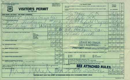
Obtaining a Permit at the Trail Head

Many of the remote trail heads in National Forests in the Northern Sierras have permit pads and pens in a box at the trail head for the convenience of local backpackers.

Call the Ranger District of the trail head your trip begins in for specific information. Many of these trail head permits are stamped with restrictions, such as the "this permit is only valid in" that particular trail head's National Forest or Wilderness Area.

I believe these "stamped" permits are a device to prevent people from taking these trailhead permits and attempting to use them in Wilderness Areas where permits are restricted. Call the Ranger District of the trail head you are interested in for more information about the availability of trailhead permits.

If you are planning a long distance backpacking trip across restricted permitting areas, such as The Yosemite National Park, or your trip hooks into The John Muir Trail coming down from Lake Tahoe, as I often do, you must have a valid permit issued by the Ranger District of your originating trailhead.

A permit stamped with "this permit is only valid in" will NOT do.

Don't depend on trail head permit boxes for backpacking trips that cross into different, or restricted, permitting authorities.

Although it is easy to obtain a thru permit outside of the restricted areas, even during the "high season," you should understand that Yosemite is trying to hard to restrict unlimited access to Yosemite and the John Muir Trail by restricting the number of permits they issue, and surrounding Forests are apparently trying to help by limiting the range of self-issued trail head permits.

As I said above, they are often restricted. So you long distance backpackers should order your permit from your trail head's Ranger District over the phone and have them send it to you well before your departure date. This is especially true for long distance backpacking trips that will cross into high-traffic areas.


Endless Backpacking Trips

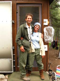
There are literally thousands of short and medium length backpacking trips that can be cut out of the Sierra Crest Trails between Lake Tahoe and Mount Whitney either following the Crest, or incorporating a section of the Sierra Crest.

For instance, you can hike a section or two of the Tahoe to Whitney trail each year, until you have walked the entire length of the Sierra Crest.

Though the routes along the Sierra Crest are this site's main focus, every trail junction and subordinate trail head along the Sierra Crest is also described, and is a viable entrance/exit option to put together a short or medium distance backpacking trip incorporating a section along the Sierra Crest.

Each of these trails can bring you onto, and off of, the Pacific Crest, John Muir, or Lake Tahoe to Yosemite trails on your own personal custom designed excursion.

I am building the permits section of this guide so that people using this site to put together their own epic trips along and around The Sierra Crest can easily obtain the permitting information and permits they need.

I have included the following list of the National Forests, Wildernesses, and Ranger Districts that administer the trails between Lake Tahoe and Mount Whitney along the Sierra Crest to make this easy.

If I did my job well you should be able to easily figure out how to find the Forest and Ranger District necessary to obtain the permits and information you will need to plan and successfully execute your trips into, or across, the most remote, as well as the most congested permit areas during the High Sierra high season.

If you don't obtain reservations you may want to begin your trip from outside the congested areas, but you will get in and through.

The following list will bring you to all the information you need about all of the Permitting Authorities between Lake Tahoe and Mount Whitney.

Well, it will when the site is finished...

top of page

Congratulations to Rick and Suzanne! You see everything if you Backpack the High Sierras long enough...

   
Backpack
Lake Tahoe
to
Mount Whitney!

Walking Ranger, Benson Lake, Yosemite Backcountry
Walking Ranger, Bensen Lake, Yosemite Backcountry
Backpack from Lake Tahoe to Yosemite!
Ranger at his cabin in Evolution Valley
Bishop Pass Ranger and his new wife, married in Big Pete Meadow the previous week with Trail Crew

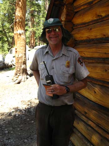
Congratulations to Ranger Rick Sayer and his new wife Suzanne. They were married on Aug 13, 2009 in Big Pete Meadow just North of the Bishop Pass Ranger Station, with the local trail crew as witnesses.

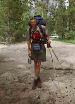
  Above: The Evolution Valley Ranger, during coordination of the evacuation of a downed Sierra Club group hiker, Aug 20, 2009.
   

Top of Page

Obtaining Permits
for
The National Forests, Parks
and their
respective
Wilderness Areas
Backpacking
from

Lake Tahoe to Mount Whitney

This site is under construction...

North
Sierra Nevada Mountain Range

From Which National Forest do we Draw our Wilderness Permit?

Permit Information

Forest, Park, and Wilderness Information
The Mokelumne and Carson Iceberg Wilderness Areas are both split along the Sierra Crest between National Forests administering their East and West Flanks.

Thus some of the North Sierra wilderness information below presents two links, each to different National Forests for the same wilderness area.

The upper links below are to contact information for obtaining permits from that forest or park.

The lower link is to that unit's descriptions of their wilderness area.

The marked routes on the maps link to more detailed maps. The red dots link to trail guide entries.

Grayed out links are duplicates of the link above it, unless the information is different..

West Flank

MAPS East Flank

Lake Tahoe Basin Management Unit Permits


Desolation Wilderness

Toiyabe
Carson Range

Desolation Wilderness Map


Lake Tahoe Basin Management Unit
Permits


Meiss Country Roadless Area Information

Toiyabe
Carson Range

Meiss Country Map

El Dorado National Forest Permits


Desolation Wilderness Information


Mokelumne Wilderness Information

Toiyabe National Forest Permits
Mokelumne Wilderness

Mokelumne Wilderness Map

Stanislaus National Forest Permits


Mokelumne Wilderness Information

Toiyabe National Forest
Mokelumne Wilderness

Mokelumne Wilderness Map

Stanislaus National Forest Permits


Carson Iceberg Wilderness Information

Toiyabe National Forest Permits


Carson Iceberg Wilderness

Carson Iceberg Wilderness Map

Stanislaus National Forest Permits


Emigrant Wilderness Information

Toiyabe National Forest Permits


Hoover Wilderness

North Emigrant Wilderness Map

Yosemite National Park Permits


Yosemite Wilderness Information

Toiyabe National Forest
Hoover Wilderness

Emigrant-North Yosemite Wilderness Map


North Sierra Facts
We can enter the Mokelumne Wilderness via three different National Forests!

Both the Stanislaus and Toiyabe National Forests each administration three wilderness areas. They share admin of Mokelumne and Carson Iceberg Wilderness, but the Toiyabe exclusively oversees the Hoover Wilderness while Stanislaus has sole jurisdiction over the Emigrant Wilderness.


Top of Page

South Sierra Nevada Mountain Range


South Sierras
coming soon!


This site is under construction...


INFORMATION

MAPS MILES


more to come...stay tuned!

High Sierra National Forests, Parks, and Wilderness Areas

Map of National Forests and Wildernesses between Lake Tahoe and Mount Whitney
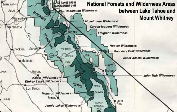
Map Credit: Forest Service, Pacific Southwest Region, "A Guide to National Forest Wilderness in California."

Large High Sierra
National Forest Map


Trailhead


Contact
Alex Wierbinski


top of page

Bear at the Silver King ford Lake Tahoe to Mount Whitney
Our guide to the Sierra Crest, including the Tahoe to Yosemite, the Pacific Crest and the John Muir Trails
Coyote at Round Top Lake on Ice
© Lake Tahoe to Mount Whitney: Crown Jewel of the Pacific Crest Trail