West Flank Peak 12960
East Whitney Rock Lake Tahoe to Mount Whitney: Your Backpacking Guide to the High Sierras Peak 1290 beyond Wanda Lake, Evolution Basin
Yosemite permit station in Tuolumne Meadows.
West Flank Mount Whitney
Tuolumne Meadows Backpacker Permit Station at Highway 120 and the road to Tuolumne Meadows Lodge
Lake Wanda North of Muir Pass


High Sierra
Backpacking

Main
Trail Guide
TRAILHEAD

High Sierra
MAGAZINE

ALL BLOG


Trail Guide

Guide Index

Maps Index

Miles-Eleva

Permits

Resupply

 
Forums

All Blog

Trails Forum

Topics Forum


Sierra
Weather

ALL
High Sierra Weather

Weather
Notes

Northern
Sierra Weather

Central
Sierra Weather

Southern
Sierra Weather


Gear

Gear List

Gettin Started

Layering

Discussion

Testing yourself and gear

Member
Favorite Gear

Gear Reviews


top of page


Yosemite National Park

Backpacking Permit Information


Languages

Translate


Trail Skills

The trail

Navigation

Camp skills

Paper Maps

Off the trail

Scrambling


Mountain
Safety

Safety Topics

Safety
Incidents

Mosquito Info

Skeeter News


Food

Resupply
FORUM

Food


Planning

40 Days to Whitney

Introduction Tahoe to Whitney

Introduction Tahoe-Yosemite


Trail Arts

Art of walking


Physical
Preperation


More
Information

Links


News
and
Science


Books


Trail Stories


Photo
Catagories

 
Social

Trail Culture


Groups


Terms and Conditions of Use


top of page


Permitting Authorities
INDEX
Lake Tahoe
PERMITS
El Dorado NF
PERMITS
Stanislaus NF
PERMITS
Humboldt-Toiyabe NF
PERMITS
PCT
or
TYT?
National Forest & Wilderness
list
National Forests map
 

Inyo
National Forest

  Sequoia-Kings Canyon
National Park


ARRRRGGGG!!
Yosemite National Park Permits
for the
Long Distance
and
Local
Backpacker


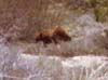
Mountain Safety Issues

HIGH SIERRA BACKPACKER ALERT?

Alerts & Notices

Inciweb
Yosemite National Park


Trails Information

Tuolumne Meadows
MAP

Yosemite
Valley
MAP

Tuolumne Meadows
PERMITS

Tuolumne Meadows
RESUPPLY

Trail Guide
NORTH
PCT-TYT

Glen Aulin
to
Tuolumne Meadows

Trail Guide
SOUTHWEST
JMT

Tuolumne Meadows
to
Cathedral Lakes

Trail Guide
SOUTH

JMT-PCT

Tuolumne Meadows
to
Donohue Pass

 
Trail Guide

START
JMT
Happy Isles
to
Little Yosemite Valley


Permits Information
 
Yosemite Permits


Yosemite
National Park

&
the
JMT, PCT & TYT


ALL
YOSEMITE
Backpacking Permits Information
BELOW


RESERVATIONS
by
Links, Phone, Fax,
&
Mailing Address


FULL CONTACT
information
follows
BELOW


Yosemite National Park
Wilderness Permit
POLICY


Yosemite
Wilderness Permit
Reservation System
DATES


Yosemite National Park
Permit Information
about the
JMT & PCT


New
JMT
QUOTAS
Donohue Pass Exit Limits


Yosemite FULL Trails
Information


Yosemite
Wilderness Permit
Reservations
by
FAX, PHONE, and MAIL


Yosemite
Permit
Stations


PCT
Association

Permit Information
on
Long Distance
PCT Permits


Yosemite
PERMIT

Questions?

209-372-0826

Monday-Friday, 9 am to noon and 1 pm to 4:30 pm.
This phone line is staffed with wilderness rangers during Summer.


Gemeral Inquires
Mailing Address

Yosemite National Park
PO Box 577
Yosemite National Park, CA 95389

General Inquires
Phone Number

(209) 372-0200


Yosemite
Wilderness Permit
Reservations
209-372-0740
Monday-Friday, 9 am to noon and 1 pm to 4:30 pm.


Yosemite Trailheads
NP PDF Trailhead
RULES MAP


Yosemite
Basic Trail Map
National Park PDF


Yosemite
Backpacker Camps


Half Dome
Permits


Historical
Opening and Closing
Dates
Tioga Road
Highway 120


High Sierra
Weather


Main Roads
in
Yosemite


Car Camping
in
Tuolumne Meadows


Tuolumne Meadows
Long Distance Backpacker
Resupply
Information


NEW
-
(NOW OLD)

New 2015-6 JMT Quotas
Donohue Pass Exit Quota Limits


WELCOME!
Resistance is futile. You Will be Assimilated.


Yosemite Backpacking Permit
News & Information


Latest
John Muir Trail & Donohue Pass Restrictions

Bad News Bears
These two notices above contain statistics that are bad news for all High Sierra backpackers. Our vast population is already larger than our ecosystem can support. Now these stats show we have even produced more backpackers than our overused High Sierra trails can withstand.


Irrational
Permit Restrictions
Spread

NEW CRAZY NORTH SIERRA
"FORESTS PERMIT POLICIES"

(Long Distance Backpacker Restrictions)

Backpackers Forum
NEW CRAZY NORTH SIERRA
"FORESTS PERMIT POLICIES"


Comments


The
Long Distance High Sierra Backpacker

across
Yosemite National Park

This guide is written North to South for Long Distance Backpackers along the Sierra Crest. Therefore Tuolumne Meadows is more of a resupply destination along our hike South to Mount Whitney than a starting point.

(See new permit restrictions above)

This is not so for most backpackers. Folks love to start backpacking through Yosemite Trailheads, and of special interest is the beginning of the John Muir Trail out of Yosemite Valley.

Happy Isles Trailhead

Local
&
Section Hikers
Complete Yosemite National Park Backpacking Permit Information is provided below and on the sidebar to our Left to make it convenient for backpackers who are section hiking the Tahoe to Whitney, Pacific Crest, and Tahoe to Yosemite Trails out of Yosemite. Or those starting the John Muir Trail, and anyone who just wants to do a nice backpacking trip around Yosemite.


The Golden Triangle is Killer.


Trail Guide
GOLDEN TRIANGLE
ROUTE DESCRIPTION


Golden Triangle
Trail Guide
INDEX
Golden Triangle
FORUM

We've got all the permit information you need to understand how to obtain a Yosemite Backpacking Permit in the link list to the Left.

The main thing is to use the early-season reservation system. We can make reservations six months in advance for dates in the Summer following. Check the Yosemite JMT page for specific dates and more information.

BACKPACKING CALENDAR
August 20s


John Muir Trail
Backpacking
Permits

The John Muir Trail uses a lottery system to award permits.

To better serve John Muir Trail hikers who are starting from Happy Isles in Yosemite Valley we offer generalized information and resources about Yosemite National Park permits and
public transportation
.

This should be helpful to all backpackers using public transportation to get into Yosemite National Park to start the JMT, as well as hikers trying to get out of Yosemite at the end of backpacking trips.

Getting in and out is easy. Yosemite is exceedingly easy to hitch hike into and out of once we get the hell out of the city.

My easy solution to problems getting Yosemite permits is never to begin trips in Yosemite. I hike in from Highway 108 along the PCT or TYT, or hike down from Lake Tahoe. Then I hike out the South end of Yosemite on the JMT-PCT.

That's how I avoid permit hassles at Yosemite:
HIKE THE LENGTH OF THE SIERRA NEVADA MOUNTAIN RANGE!

I HIKE HUNDREDS OF MILES; HOW DARE I.

Some of the Park and Forest "officials" believe I hike the long trails to evade their permit restrictions!

Love needs no permit.


Apparently the NPS is working to end Long Distance Backpacking
in the Sierra Nevada, because it's a
"LOOPHOLE"
in their attempts to limit the numbers of hikers on the PCT-JMT!

That's just crazy thinking and bad policy.


Tahoe to Whitney Permits
onto the
Golden Triangle

I call the alternative route from Tuolumne Meadows to Yosemite Valley "backwards" on the John Muir Trail, and back to to the JMT in Lyell Canyon, "The Golden Triangle." It is quite a fine stand-alone hike around the heart of Yosemite National Park as well as a sweet "extra" section to add onto a Tahoe to Whitney backpacking trip as we hike through Yosemite National Park.

When obtaining permits to hike from Tahoe to Whitney from the Lake Tahoe Basin Management Unit (can you?) we make-sure that we write in all the killer campsites we can possibly foresee if we are adding in the Golden Triangle, if we plan on hiking the JMT backwards down to Yosemite Valley from Tuolumne Meadows when we hit the end of the Tahoe to Yosemite Trail.

Guide Index
Tuolumne Meadows to Happy Isle

DOWN
Rather than picking up the John Muir Trail South along the Sierra Crestline out of Tuolumne Meadows, we're going to hike down to the Valley along the JMT.

AND BACK
Hiking back out of Yosemite Valley triggers us to also specify campsites up the Merced River on our way over Voglesang on on our permit so we can to rejoin the John Muir Trail in Lyell Canyon.
We'll drop into Lyell Canyon from Voglesang High Sierra Camp to pick up the JMT a few miles South of Tuolumne Meadows, and complete the Golden Triangle.


Permit Planning

ARRRRGGG!
The important point here is to understand the importance of properly planning out our long distance backpacking trip to designate and name all the campsites we plan on occupying on our through-permit when we cross high-use and highly patrolled areas such as Yosemite.

But route and campsite selection come after getting ready at least six months ahead, and having the flexibility to accept reservation dates that are available, rather than those preferred.


PCT PERMITS

PCT long distance permits are highly restricted.

Long distance PCT permits only apply to the PCT corridor. No hiking out of that corridor is allowed. If you find yourself approaching Yosemite and you are feeling froggy, like you've got to hike down to the Valley, you must obtain another permit for that, and every other, extra segment added to your trip as you hike down the long trail.


Yosemite Permits

VERY BUSY
Those backpackers starting their backpacking trips from Yosemite have to deal with the hassle of getting a permit from Yosemite National Park. Yosemite makes it as easy as possible, but that place is very busy.

City Busy
This is a function of the international and national popularity of Yosemite potentially crowding backcountry trails during peak backpacking and toursit season.

THE RESERVATION SYSTEM
Yosemite responded with trailhead and zone quotas while designating 60% of permits be available for pre reservations and 40% of permits for issuing in person to backpackers at the Yosemite Permit Stations.

This keeps the trails fairly quiet, while making getting permit reservations or permits at Yosemite fairly hectic, from my observations.

Personally I have never drawn a permit from Yosemite. (UPDATE: A First, I drew a permit from Tuolumne Meadows the day before the Fed shut down in Oct 2013 for a hike to Yosemite Valley from Tuolumne Meadows! What a delightful experience... there was virtually nobody in Yosemite! WOW!)

My solution to Yosemite's permit issues has been to hike into Yosemite rather than start trips in Yosemite.
I've walked to Yosemite every time I've visited (except once), at least as an adult for the last 20+ years.

I do remember a couple of car trips to the Valley in the early '60s with the family. Bears at the dump and the firefall still stick in my mind to this day, along with my amazement at the spectacular rock rising straight up from the floor of Yosemite Valley.

Decades of watching backpacker's ordeals obtaining Yosemite permits as I hike through has given me a few insights, if you have to get a permit from Yosemite.

1> Flexibility is Key. Don't mark out your vacation days-dates before you get your reservations for a Yosemite permit. You may have to settle for your second or third selection for trip dates, especially if your trip dates are on or near major Summertime holidays on popular trails.

2> Don't bet on getting the permit dates you want in person from the Yosemite Permit Stations. I've watched 25 backpackers line up an hour before the Tuolumne Meadows Permit Station opens, all hoping to get their desired permits, while only a few succeed.

Me? I am going to sleep in on my Resupply Days...

I have consistently met the nicest backpacking folks from around the world and the whole USA at the Tuolumne Meadows Backpacker's Camp.
Among those who are getting ready to start or are just finishing Yosemite backpacking trips there is always a substantial group waiting to get one of the daily release of permits.

Those who don't get permits are fated to repeat this the next day, but the Rangers generally take the names of those who failed to get permits one day to assure they get one the next.


High Sierra National Forests, Parks, and Wilderness Area Map

What's Going on Here?
Check out Yosemite's past to understand its future

Yosemite
The Park
and Its Resources

A comprehensive History of Yosemite National Park


Tuolumne Meadows
MAP

Tuolumne Meadows
PERMITS

Tuolumne Meadows
RESUPPLY

Trail Guide
NORTH
PCT-TYT

Glen Aulin
to
Tuolumne Meadows

Trail Guide
SOUTHWEST
JMT

Tuolumne Meadows
to
Cathedral Lakes

Trail Guide
SOUTH
JMT-PCT

Tuolumne Meadows
to
Donohue Pass


Backpacking Information
NORTH YOSEMITE BACKCOUNTRY
Trail Guide Information

The trail guide is currently complete from Lake Tahoe to Tuolumne Meadows, so we only have guide information down to Tuolumne Meadows from the North.

As the draft edition of the North guide is brought to completion we will begin writing the guide South from Tuolumne Meadows to Mount Whitney.

Stay Tuned!

We've got much more information on the way.


North
of
Tuolumne Meadows

Tahoe to Whitney Trail Guide Maps
Tuolumne Meadows Hiking Map
15 minute topo hiking map

Backpacking Maps Index
Highway 108 to Tuolumne Meadows


Miles and Elevations
PCT-TYT
Toiyabe-North Yosemite
Sonora Pass to Tuolumne Meadows
PCT
Miles and Elevations
Stanislaus-Emigrant
Kennedy Meadows to Jack Main Canyon
TYT
Miles and Elevations

The Southbound PCT and TYT intersect in the far Northwestern corner of Yosemite in Jack Main Canyon to share the majority of the remaining trail South to Tuolumne Meadows.

TRAIL GUIDE CONSTRUCTION PROGRESS:

South
of
Tuolumne Meadows

Tahoe to Whitney Trail Guide Maps

South-Central Yosemite Hiking Map
30 minute topo hiking map

Donohue Pass to Fish Valley Map
30 minute topo hiking map


Miles and Elevations
PCT-JMT
120 to Reds Meadow
Miles and Elevations
TM to Yosemite Valley
Miles and Elevations
The Southbound PCT and TYT intersect in the far Northwestern corner of Yosemite in Jack Main Canyon to share the majority of the remaining trail South to Tuolumne Meadows.

(More Information is being constantly put online...)


Backpacker Camping in Yosemite
Camping for Through Hikers and Backpackers starting or finishing trips
Backpackers Camps in Yosemite National Park
We are referring to the backpacker's camps in Tuolumne Meadows and Yosemite Valley where we spend a couple of nights as we rest and resupply for the next segment of our trip South.


Yosemite National Park Maps
Yosemite Trailheads
NP PDF Trailhead RULES Map
Yosemite Basic Trail Map
National Park PDF
PDFs open in a new tab.


The Trailheads map above-Left lays out the minimum distance one has to hike out from the various Yosemite Trailheads to legally camp.


top of page


General Information
about
Permits


Most long distance backpackers (excepting John Muir Trail hikers) pulled their permits for hiking through Yosemite far from Yosemite. Permits for backpacking trips are generally drawn from the Ranger District that administers your starting traihead.

I've hiked the JMT five times and never began out of Happy Isles. Four of the five times I've hiked the JMT I've started out of Lake Tahoe, and out of Kennedy Meadows on Highway 108 once.

I've hiked down to and back out of Yosemite Valley through Happy Isles on two of these trips to investigate the beginning section of the JMT from the Valley to Tuolumne Meadows, to check out the Valley, and more of Yosemite National Park than if we stayed up on the Sierra Crestline Trails.

So Far, So Good
Permits issued from our starting trailhead are good through all subsequent National Forests, Wilderness Areas, Special Zones and National Parks that we named on our permit.
Generally, no additional permits are required, though forest managers sometimes come up with novel ways of limiting access to specified areas, such as during the era of the "Whitney Zone" stickers and other such nonsense.

At the time of this writing (2015) there are no additional special permits necessary to hike between Tahoe and Whitney. Ask the person issuing your permit if there are any extra restrictions they are aware of, and make sure you name all the locations you wish to camp on your permit.

Also inquire as to fire rules. Some areas that issue permits require a separate permit for fires and stoves than your hiking permit, while others do not. Our original permit will suffice for both, in most cases. The deal is that High altitude areas are increasingly banning fires, a very good thing. In any case our original permit is sufficient for all subsequent administrative units we will cross into, if they are named on your original permit.

Update: Half Dome needs a special permit, even for through hikers who named it on their permits.

The Permit Planning page in the planning forum is the place to read up on potential permit restrictions/problems and post up any information or concerns you have about permit restrictions.


PCT HIKERS
There are two main types of Pacific Crest Trail hikers. There are section hikers and those trying to get it all in one shot.

Section hikers have the advantage of crafting a custom permit from the administrative unit of their starting trailhead that names all of their proposed campsites on and off the Sierra Crest. This makes it possible and legal for section hikers to explore side trips and scrambles off the main route of the PCT.

PCT through hikers who are using a Long Distance PCT Permit are not allowed to depart from the narrow confines of the "PCT corridor" without an additional permit from the local administering authority.

If a Northbound PCT hiker wants to hike down to the Valley over Voglesang then back up to the PCT at Tuolumne Meadows on the JMT they have to get a permit in Mammoth Lakes to add in this segment to their trip.

top of page


Lay of the Land
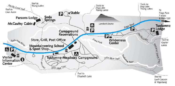
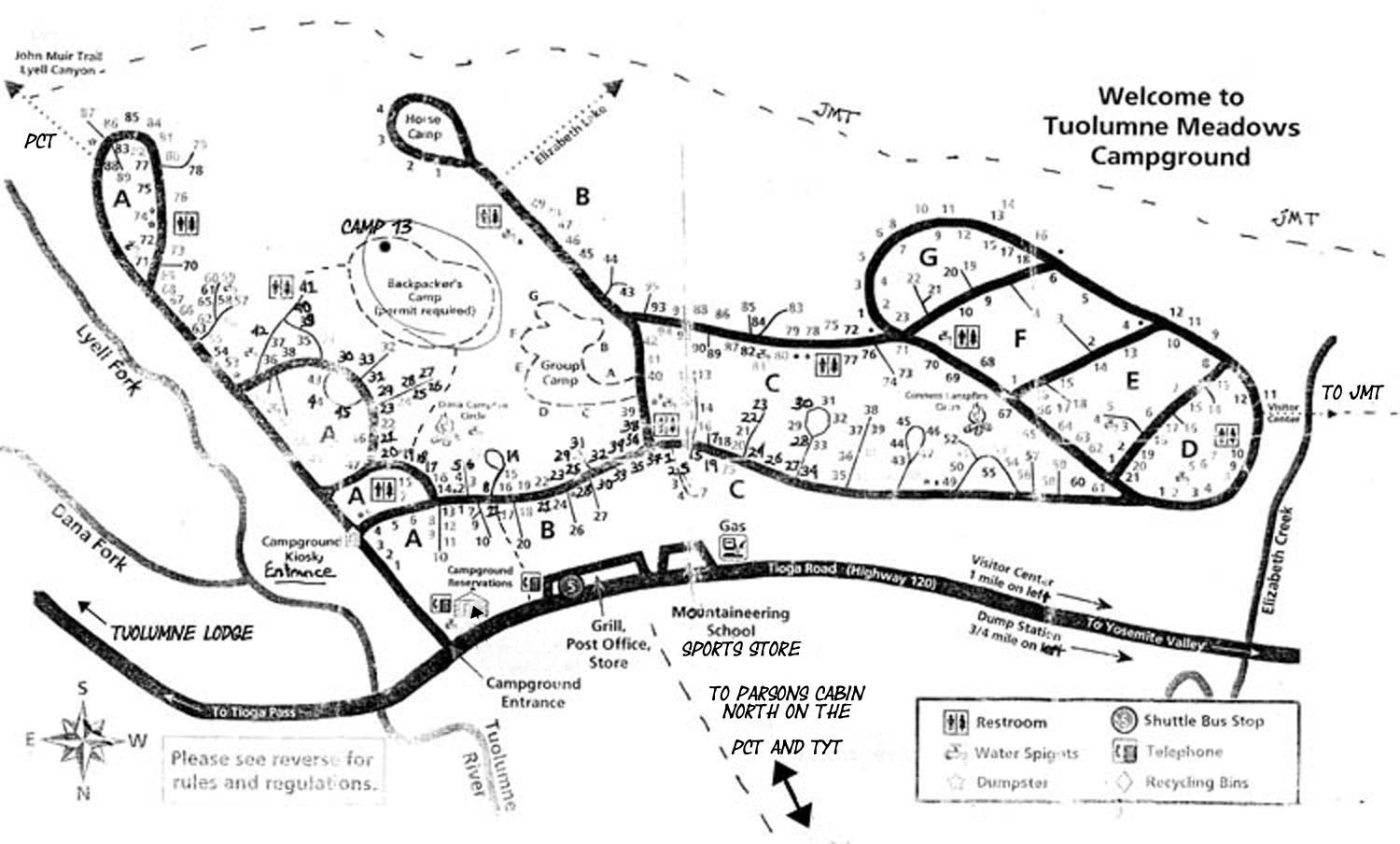
Maps of Tuolumne Meadows
PERMIT STATION

Store, Cafe, Post Office, Backpacker's Camp and Trails

Map of Tuolumne Meadows Facilities.

Larger Tuolumne Meadows Facilities MAP

This map locates the services at Tuolumne Meadows in relation to the trails. As I almost always walk into Tuolumne Meadows, I present Tuolumne Meadows as it appears to us Southbound "walk-ins," above.

Note I marked-in the use trail to Parsons Cabin from the Store and Post Office, rather than the dirt road from Parsons Cabin to the Visitor Center, which is located one mile to the West down Highway 120. The Visitor Center is out of the far-Right of the map above.

The permit station is out of the East, or far-Left side of the map above.

Note the location of both the Visitor and Wilderness Centers bracketing our Resupply Facilities on the map below.

Southbound PCT-TYT
into
Tuolumne Meadows
I walk South directly to the Tuolumne Meadows Facilities from the Parsons Cabin Bridge, rather than follow the offset to the Visitor Center, which then has me walking East along Highway 120 to the Tuolumne Meadows Resources I crave.

JMT
into
Tuolumne Meadows
Note also that the Southbound JMT route coming up and over the Cathedral Range from Yosemite Valley circles around the backside, the South side of Tuolumne Meadow's facilities. Most JMT hikers are not bypassing Tuolumne Meadows, and this route takes us further away from our rest and resupply facilities, so we hike up towards the visitor center a few feet to find and follow the trail East into the Car Campground that runs parallel with and between Highway 120 and the JMT to the Post Office, Cafe, and Store, then over to the Backpackers Camp.

Again, there is no reason to walk the offset around the back side of Tuolumne Campground when the most direct route is through the Car Campground.

Tuolumne Meadows Resupply Page

Backpackers Camp
Note the location of the backpacker's camp. I noted the small trail from the East side of the Tuolumne Meadows Store into the car campground, and the location of the trail to the East of the Dana Campfire Circle up to the entrance to the backpacker camp, which is located on the top of the rise above the Dana Campfire Circle.

This route passes by the bathroom and water facilities serving the backpackers camp, as does the trail I marked on the East side of the Backpacker's Camp to the bathroom and water facilities there.
Bathrooms and water are shared with the surrounding car campers.


Yosemite National Park


Backpacker Information
Backpackers Camp Information


Local
and
Long Distance
Transportation

Tioga Road Shuttle Bus Main Roads in Yosemite


Historical Opening and Closing dates for Highway 120


YARTS
Merced Amtrack Station
to
Mammoth Lakes
via
Yosemite Valley and Tuolumne Meadows


All YARTS Schedules YARTS Schedules and Fares pdf


YARTS MAP pdf


East Flank
Transportation

Highway 395 Corridor


Eastern Sierra Transit
Reno, Nevada
to
Lancaster, California

Highway 395 Routes
Reno
to Lancaster

East Sierra Transit
P.O. Box 1357
Bishop, CA 93515

760-872-1901


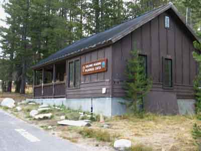
Backpacking Permit Station
at the

Wilderness Center
in
Tuolumne Meadows

As this permit page is set up for backpackers starting trips out of Tuolumne Meadows the map below offers the clearest depiction of the location of the Permit Station at the Wilderness Center:

Tuolumne Meadows Wilderness Permit Station on a Map.
As parking, camping, and backpacking in Tuolumne Meadows are overwhelmed and overstrained by its popularity and therefore constrained by quotas and restrictions I far prefer to backpack into Tuolumne Meadows from Trailheads located far to the North of Yosemite.
Both the maps above are products of the National Park Service. Thanks NPS.


Larger
Tuolumne Meadows
Facilities MAP


Wilderness Permits
Available
at the
Wilderness Center

Tuolumne Meadows Wilderness Center.


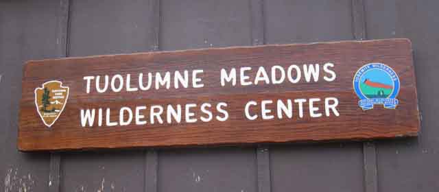
Tuolumne Meadows Wilderness Center Permit Station

Tuolumne Meadows Wilderness Center and Permit Station.
The Permit Station is located on the West side of the intersection
between the Tioga Road and the road to Tuolumne Lodge.


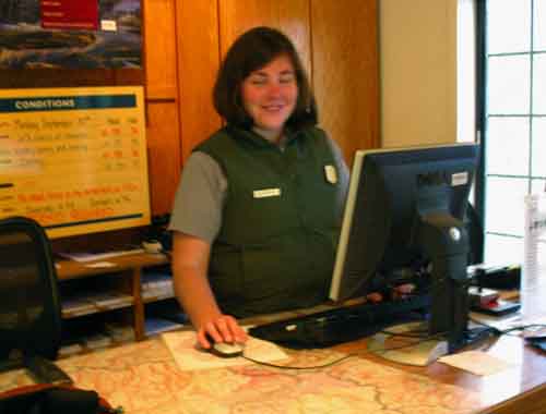
Great Staff at the Federal Parks

Permit Ranger at Tuolumne Meadows Yosemite.
Jen Vandragt making sure everyone knows the rules, and does not act like fools...

These fine folks will do everything they can to help you reach your goals. But it may be impossible. If you have a reservation you are OK. If you do not, you will have to line up at this permit office to take a shot at obtaining one of the available permits.

Bear proof food protection is required in the Yosemite Backcountry, and they will rent you one at the Wilderness Center if you don't have one of your own.
I use a bear canister during Summer backpacking in the Sierra Nevada regardless of local regulations. I am real good at hanging food from trees, and I've dealt effectively with the bear threat for decades, and I still use and recommend that you use a good bear proof food container.

On the other hand, even the coolest Rangers have repeatedly informed resistant backpackers about the necessity of good backcountry practices to protect both backpacker and backcountry, then been tasked with cleaning up the mess of poorly-behaved backpackers.


Local Resources

Tuolumne Meadows
Map
Tuolumne Meadows
Resupply
GUIDE
Tuolumne Meadows
to
Glen Aulin
GUIDE
Tuolumne Meadows
to
Cathedral Lakes
GUIDE
Tuolumne Meadows
to
Donohue Pass


High Sierra National Forests, Parks, and Wilderness Areas

National Forests and Wilderness in California
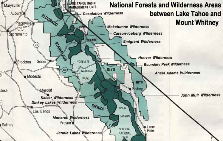
Map Credit: Forest Service, Pacific Southwest Region, "A Guide to National Forest Wilderness in California."


Large High Sierra
National Forest Map


Trailhead


Contact
Alex


top of page

Bear at the Silver King ford Lake Tahoe to Mount Whitney
Our guide to the Sierra Crest, including the Tahoe to Yosemite, the Pacific Crest and the John Muir Trails
Coyote at Round Top Lake on Ice
© Lake Tahoe to Mount Whitney: Crown Jewel of the Pacific Crest Trail