High Sierra
Backpacking
Trail Guide
Forums
Sierra
Weather
WeatherNotes Northern
Sierra Weather
Gear
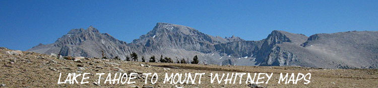
Backpacking the High Sierra
LAKE TAHOE
to
MOUNT WHITNEY
USGS High Sierra Topo
Backpacking
MAP
INDEX
Languages
Trail Skills
Mountain
Safety
Food
Planning
Trail Arts
More
Information
Social
BACKPACKING MAPS
of the
Long Trails
along the
High Sierra Crest
from
Lake Tahoe to Mount Whitney
TYT - PCT - JMT
and
Much More
Mapping
North Sierra
Central Sierra
South Sierra
|
||||||||||||||||||||||||||||
| PCT-TYT JMT The Basic Line of High Sierra Trails across California |
||||||||||||||||||||||||||||
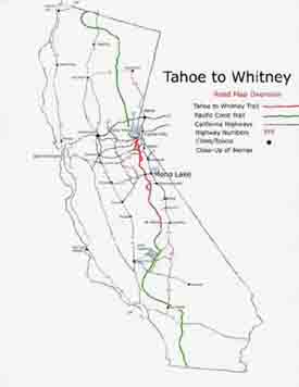 |
The Lake Tahoe to Mount Whitney on a California Map. The Pacific Crest Trail and High Altitude Sierra Nevada trails between Lake Tahoe and Mount Whitney, and within California. Lake Tahoe to Mount Whitney Pacific Crest Trail
Lake Tahoe to Mount Whitney |
|||||||||||||||||||||||||||
Trail Section One Desolation Wilderness Desolation Wilderness Map RAW TYT-PCT
South Tahoe Basin
South Tahoe Basin |
||||||||||||||||||||||||||||
|
||||||||||||||||||||||||||||
 PCT and TYT South through the Carson Pass Management Area |
Trail Section Two The Mokelumne Wilderness North End
PCT & TYT
Tahoe to Yosemite Trail
Pacific Crest Trail |
|||||||||||||||||||||||||||
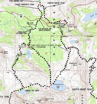
Departing The full-sized Carson Pass Region Topo Map above details our trail options where the Tahoe to Yosemite and Pacific Crest Trails split up exiting the Lake Tahoe Basin. The TYT and PCT are our two route options between Highways 88 and 4. The TYT has a significant unmaintained segment of route along our trail. There are many nice destinations for short trips around Carson Pass too, and extensive backpacking in remote areas of the Mokelumne Wilderness. |
||||||||||||||||||||||||||||
| TYT Backpacking Maps for CLASSIC Lake Alpine Lodge Resupply North and South on the TYT |
||||||||||||||||||||||||||||
|
Resupply Point #1 Lake Alpine Lodge Highway 4 Lake Alpine Region
Lake Alpine Lodge Both the Pacific Crest and Tahoe to Yosemite Trails cross Highway 4. The TYT crosses Higway 4 on the East side of Lake Alpine, 3/4 of a mile East of our Resupply Point at the Lake Alpine Lodge. Lake Alpine is sandwiched in between these two fine wilderness areas. Ebbetts Pass, where the PCT crosses Highway 4 is about 15 miles East of Lake Alpine.
Resupply Information and Local Resources
top of page |
|||||||||||||||||||||||||||
|
||||||||||||||||||||||||||||
Both the TYT and PCT hike South through the Carson Iceberg Wilderness on their respective routes. The Tahoe to Yosemite along the Western flank of the Sierra, the Pacific Crest Trail along the Eastern flank. We can mix bits of both routes using the four trails that connect the TYT and PCT across the Carson Iceberg Wilderness. |
Trail Section Three Encompassing
PCT & TYT
Tahoe to Yosemite Trail
Pacific Crest Trail Maps |
|||||||||||||||||||||||||||
|
||||||||||||||||||||||||||||
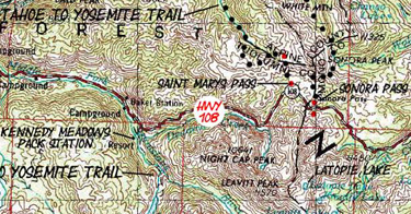
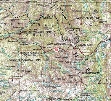
Resupply Point #2 Kennedy Meadows Pack Station Kennedy Meadows Pack Station
Sonora Pass Region Tahoe to Yosemite Trail Kennedy Meadows Pack Station is my favorite stop on the Tahoe to Yosemite Trail, and virtually mandatory for Pacific Crest and Tahoe to Yosemite Trail hikers. Why? Because Kennedy Meadows roughly splits the 150 mile distance from Tuolumne Meadows to Highway 50 in the Lake Tahoe Basin. Kennedy Meadows sits along the Tahoe to Yosemite Trail route up Summit Creek, which offers excellent local as well as long distance backpacking. |
||||||||||||||||||||||||||||
 |
||||||||||||||||||||||||||||
Kennedy Meadows Pack Station
Kennedy Meadows Backpacker
Kennedy Meadows Pack Station
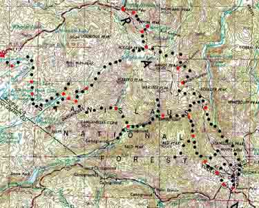
Stanislaus National Forest
|
||||||||||||||||||||||||||||
PCT & TYT |
||||||||||||||||||||||||||||
 |
Trail Section Four Crossing
Tahoe to Yosemite Trail
|
|||||||||||||||||||||||||||
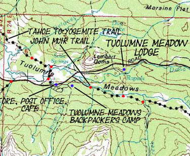 |
Resupply Point #3 Tuolumne Meadows Tuolumne Meadows Tuolumne Meadows Resupply |
|||||||||||||||||||||||||||
Trail Section Five Yosemite
Index Map
Map
Ansel Adams Wilderness
Backpacking Permits JMT & PCT
|
||||||||||||||||||||||||||||
In Progress...Stay Tuned for More! |
||||||||||||||||||||||||||||
| Alternative Route The Golden Triangle JMT The Heart of Yosemite Valley Drainages |
||||||||||||||||||||||||||||
Tuolumne Meadows Central Yosemite Wilderness Executing TM to Valley John Muir Trail Map
Backpacking Permits JMT
|
Tuolumne Meadows | |||||||||||||||||||||||||||
| Yosemite Valley Backpacker Resupply |
Yosemite Valley Resupply | |||||||||||||||||||||||||||
| The Golden Triangle back to Southbound JMT in Lyell Canyon Yosemite Wilderness Up the Merced River |
||||||||||||||||||||||||||||
Yosemite Valley Central Yosemite Wilderness
"The Golden Triangle II"
Backpacking Permits JMT
|
||||||||||||||||||||||||||||
Reds Meadow |
||||||||||||||||||||||||||||
Resupply Point #4 Red's Meadow Minaret Road Mammoth Lakes |
||||||||||||||||||||||||||||
Reds Meadow and Mammoth Resupply Page
Reds Meadow-Mammoth Lakes
|
||||||||||||||||||||||||||||
Trail Section Six John Muir Wilderness Backpacking Maps Region Backpacking Map
Backpacking Permits JMT & PCT
|
||||||||||||||||||||||||||||
| Alternative Route South Reds Meadow through Fish Valley to VVR |
||||||||||||||||||||||||||||
Red's Meadow John Muir Wilderness Backpacking Maps Region Backpacking Map
Backpacking Permits JMT & PCT
|
||||||||||||||||||||||||||||
Resupply Point #5 Vermillion Valley Resort Last Interaction: Thank god they are for sale! |
||||||||||||||||||||||||||||
Vermilion Valley Resort Resupply Page
VVR Site: Resupply Information
VVR FOR SALE |
||||||||||||||||||||||||||||
Trail Section Seven John Muir Wilderness Backpacking Maps Region Backpacking Map
Backpacking Permits JMT & PCT
top of page |
||||||||||||||||||||||||||||
Resupply #6 Muir Ranch A fine, quiet resupply experience. No Road Access |
||||||||||||||||||||||||||||
|
Muir Ranch Website
Muir Ranch Website June through September: See Calendar |
||||||||||||||||||||||||||||
Trail Section Eight Kings Canyon National Park Backpacking Maps Region Backpacking Map I
Region Backpacking Map II
Backpacking Permits JMT & PCT
top of page |
||||||||||||||||||||||||||||
Mount Whitney Portal Doug's Portal Burgers Portal Road Lone Pine |
||||||||||||||||||||||||||||
Contact
Alex Wierbinski
Lake Tahoe to Mount Whitney
Your guide to backpacking the Sierra Crest, including the Tahoe to Yosemite, the Pacific Crest, and John Muir Trails