

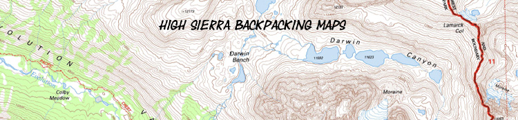
The excellent scramble up to Darwin Bench and Canyon preceeding entry into Evolution Basin.
High Sierra
Backpacking
Trail Guide
Forums
Sierra
Weather
WeatherNotes Northern
Sierra Weather
Gear
The BEST
Paper and Online
High Sierra Backpacking Topo Trail Maps
Topo Hiking Maps
to
Plan and Guide
our
Tahoe to Yosemite, John Muir, and Tahoe to Whitney Backpacking Trips
Languages
Trail Skills
Mountain
Safety
Food
Planning
Trail Arts
More
Information
Social
High Sierra Backpacking
|
||||||||||||||||||||||||||||||||||||||||||||||||||
Compass Point Our area of coverage spans from the Desolation Wilderness in the West Tahoe Basin hiking South across the Mokelumne, Carson Iceberg, Emigrant, Yosemite, Ansel Adams, John Muir, Sequoia and Kings Canyon Wilderness Areas from the Lake Tahoe Basin down through the Whitney Portal: Tahoe to Whitney We look for the best trail maps to hike from Tahoe to Whitney by finding the best maps from the range offered for each of this trip's components. We already have the best maps for planning High Sierra hikes here on Tahoe to Whitney. Below we explore our paper and digital map resources. |
PAPER
High Sierra
Backpacking
Maps
Planning Maps Tahoe to Whitney's guide maps are designed to impart broad understanding and context, as well as revealing terrain details, route options, best campsites, and potential scrambling destinations during our planning process. You are welcome to print out Tahoe to Whitney High Sierra Maps for your personal & non-profit group uses. At your own risk... The next step is getting the best maps for field use. Best Maps for Trail Use Then there are the various providers of digital maps.
Best Overall Below we The Future The Present Have an excellent map resource? Current Field Use from Lake Tahoe to Mount Whitney High Sierra Paper Trail Maps Links to Paper Map Vendors
Paper Maps Please infom of any good map sources you know! |
Quick Links to BUY PAPER MAPS |
||||
Paper USDA
Wilderness Press Desolation Wilderness
USDA
Wilderness Press
USDA
Tom Harrison |
EXCEPT PAPER |
Paper
PUBLIC SERVICE
PUBLIC SERVICE Yosemite Conservancy
National Geographic
National Geographic Maps |
||
To our Left we present commercial mapping services, to the Right our public-spirited mapping options, and the official government vendors of PAPER maps covering the High Sierra Trails from Tahoe to Whitney are listed above. The list runs North to South from Top to Bottom. The lists are intended to merge together to form one complete list of our available mapping options. I suggest purchasing from the Public Service Organizations who support our Forests and Wilderness Areas where possible. The maps of the public-minded organizations do not cover the entirity of our Tahoe to Whitney hike, so we will likely have to weave together maps from various sources. Thus the lists are spaced to merge in linear order. We also have qualities imparted by individual map makers. Harrison is noted for their JMT map package. Wilderness Press for their Emigrant Wilderness and Yosemite Maps. For the areas not covered by the public-minded or the exceptional private-map services, we rely on the "standard;" the official National Forest Wilderness PAPER Maps. I prefer these for most trips. They have a good balance between scope and detail.
I am planning on, and gradually looking into, publishing the maps on Tahoe to Whitney as a custom map-set for the entire Sierra Crest and its High Flanks.
|
||||
We'll see how that works out...
Let's Get Us Some
--> Pacific Crest Trail Maps <--
---> Tahoe to Yosemite Trail Maps <---
&
---> John Muir Trail Maps <---
TRAIL USE MAPS
Current Field Use
This
High Sierra Trail
Guide
contains a
Comprehensive
selection of
Customized
USGS
DIGITAL
Tahoe to Whitney
Trail Maps:
North Sierra
On-Guide
Tahoe to Whitney
DIGITAL
High Sierra
Backpacking Trail Maps
|
|||||
Center of the Sierra Nevada
Effective Center of the Sierra
Tuolumne Meadows Trail Map
South Sierra
On-Guide
Tahoe to Whitney
DIGITAL
High Sierra
Backpacking Maps
|
||||
|
||||||||||||
| Related Topics Map and Navigation Skills |
|
Trail Maps Well, we all know I will be carrying paper maps. But what kind? The best map for you will be determined by your preferences and the logic of your trip. It could be paper or electric, it could be a larger or smaller scale. Detail Vs. Scope The Map Market National Forest The National Forest maps are huge. National Forest Maps are big, heavy, and bulky. These are the go-to maps for car campers, but completely unsuited for trail use. The Mother Map The commercial map services re-scale, resize, and reformat the federal maps with custom route marking, elevation, and distance information. Commercial map services such as Harrison, Wilderness Press, and National Geographic sell scaled-down, reformatted, customized versions of the federal wilderness maps. Halfmile has laid out PCT strip maps based on his nicely customized use of the USGS 7.5 map series. USE Balance your Factors If we are following the PCT route from Lake Tahoe to Mount Whitney the Halfmile Maps are excellent strip maps. Their drawback is that they offer very little understanding of the logic, layout, and broader context of the surrounding terrain. But they well cover the trail itself. Two Approaches Our maps, like the rest of our gear, will be stripped down to its most basic utility. A different approach is represented by hiking from Tahoe to Whitney with the intention of getting to know as much of the High Sierra Terrain as we can absorb. The logic of our trip guides our Paper Map Availability South Sierra Paper Maps TYT/Alternative Routes between Tahoe and Whitney The Feds Map Innovations The USGS makes it possible to create our own custom maps. National Geographic has commercial mapping software with more powerful features. Using these tools allows us to create our own maps balancing detail and scope to our purpose. Commercial Services Then we have the more specialized re-formatting of the USGS and NF maps used by vendors such as Tom Harrison for his JMT map series, and Wilderness Press and National G have re-scaled and re-formatted these National Forest Wilderness Maps in a way folks prefer over the more bulky National Forest Maps. These maps are scaled down to cover a strip of terrain along the route of the JMT. They offer a good balance between scope and detail.
I like them all. Wilderness Press, NatGeo, and Harrison are all sufficient maps. USGS and National Forest Maps provide the data all the commercial maps are based on. |
The majority of the trail distance between Lake Tahoe to Mount Whitney is composed of the Pacific Crest and John Muir Trails. You can vary off in many place to take alternative routes, but these two routes are backpacking superhighways.
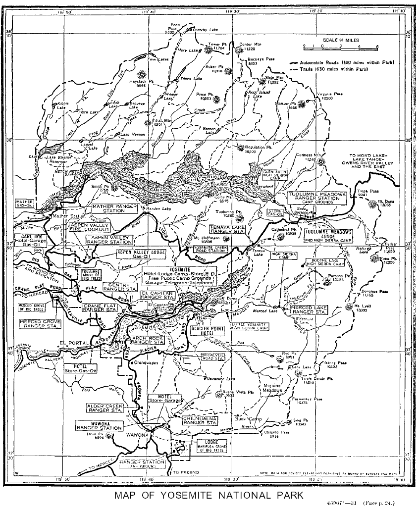
1931 map of Yosemite National Park
The Pacific Crest Trail has a trailbed that is so worn so deeply into the Earth that it will be visible for decades across huge stretches of the High Sierras, as the Oregon trail is still visible across great tracks of the Great Plains today. It is that deeply worn into the terrain. So too is the John Muir Trail route, though much of it crosses hard rock and leaves less impact on the terrain.
The PCT is so deeply etched into the terrain it can be observed from low Earth orbit. Its surface so polished by footsteps that it reflects and glows in ambient light during nightime. Besides the "reality" of the overuse of the PCT, it is also deeply buried in expectations.
Folks actually believe they "should" have a perfectly maintained trail bed with clear signage. These are typically the same folks who don't break in boots while not believing in blisters, who don't pack enough food or insulation to deal with hunger and cold.
My point is that it does not matter what our expectations are in the face of reality, except to measure our ignorance by the distance between the two, when it is too late.
Tune your expectations to reality. If it sounds too good to be true, it probably is. Reexaming that expectation, and plan for its failure:
"What if..."
We have a wide variety of on-trail map options at our disposal. For planning trips I prefer to rely on the Original USGS 7.5 and 30 minute maps that every other commercial mapping system are based on. These are the maps used, modified, and presented by Tahoe to Whitney.
Free Downloadable USGS Topo Maps
Planning Maps
We can obtain and download every 7.5, 15, and 30 minute map, as well as the 1 x 2 degree large-scale maps that the USGS has compiled at the USGS store. Follow the instructions to navigate the Google Map to the Sierra, zoom in, click "mark points," and the USGS map grid will appear. Select the specific maps at the different scales your desire, and download.
Downloading the TerraGo tool with the maps allows you to accurately measure the mileage of the mapped routes. Be aware that trail route have changed since the maps were last updated. These maps and the Geo-tool both operate on the Adobe Reader.
This will allow us to build up a library of the USGS maps covering the High Sierra. These maps are excellent for planning trips and making yourself familiar with the surrounding terrain. But USGS 7.5 minute maps are not the best for on-trail use. They are plain paper and break down quickly, and their 7.5 minute scale is much too detailed making them too large for long-distance backpacking. The number and weight of maps necessary to cover even a medium-distance Sierra backpacking trip would be too weight-prohibitive to carry.
It is the classic conflict between scale, detail, and weight.
Regional Trail Maps
Public Trail Maps
A most fundamental map for the first time backpacking visitor to a backpacking area is an excellent big-scale trail map. The Forest Service offers maps that cover each wilderness in their forest as well as maps of their whole National Forest. These are what I am referring to when citing, "National Forest Wilderness Maps," or "Wilderness Maps."
These maps are the gold standard for field use and indispensable for travel across even the highest use trails in the Sierras. These maps offer the best combination of wide context and deep detail. Nonetheless, the Forest Service offers maps that cover each wilderness in their forest as well as maps of their whole National Forest. Those whole-forest map are much too large for field use.
Forest Service Wilderness Maps
I use the 1:63360 scale Forest Service Wilderness Maps for the Mokelumne and Carson Iceberg Wilderness Areas. The only problem is that they are still relatively large and heavy. This is where the private map companies have found a niche market. They very well may have a presentation/format that better suites your needs than the larger, more generalized National Forest Wilderness Maps.
Custom Presentations
Thus the Harrison JMT Mapset, the National G JMT Map, Halfmile, and Wilderness Press offer customized map presentations for more specialized audiences.
Tahoe to Whitney Mapset
Tahoe to Whitney is on the same trail. I am planning to translate all our online Tahoe to Whitney Maps into a complete Tahoe to Whitney Paper Mapset. The paper mapset will be complimented with a digital version. The digital mapset will link to major blocks of trail data from the guide. But first I must complete the trail guide, finish all its maps, and complete the transition of the Backpackers Forum into an active-publication High Sierra Backpacking Magazine. This is a long trail.
In the meantime, you are welcome to print and use Tahoe to Whitney Maps for your own personal and non-profit use. With my permission, of course.
Public or Commercial?
and the
MAP GAP
Sometimes we have a choice between public or commercial maps, other times we have just one or the other.
Nobody makes "aftermarket" maps for the Mokelumne or Carson Iceberg Wilderness, but we have "commercial" maps available for the Emigrant and Yosemite Wilderness Areas, and Kings Canyon National Park. All these areas have both public and private map offerings.
Despite this fairly comprehensive private and public trail map coverage of the Sierra Nevada Mountain Range, I always have a hard time finding good maps covering the Sierra Crest from Mammoth Lakes to the North end of Kings Canyon National Park.
This would be primairly the John Muir Wilderness Area, for which there is no Forest Service Wilderness Map. The only paper maps covering John Muir Wilderness from Mammoth to Muir Ranch are the Halfmile strip maps, Harrison's custom JMT Map Series, The National G and other JMT maps, and the maps here on Tahoe to Whitney.
Non-Profit & Commercial
Trail Maps
Private commercial and non-profit vendors also offer regional maps, such as those, "Wilderness Area Maps" by Wilderness Press and Sierra Maps dot Com.
(National Geographic is now a division of Fox as of Sept., 2015.)
The 1:125000 Wilderness Press Map of Yosemite and Emigrant Wilderness offer a bit less detail, but offer a wide scope in a smaller, lighter map than the TWO National Forest Wilderness Maps that would be required to cover the same area. Further to the South, the 1:111850 National Geo map of Kings Canyon National Park is my preferred map for the Southern End of the Tahoe to Whitney hike. It well covers the length of Kings Canyon from the Piute Creek Bridge to the Whitney Portal.
Switching Maps In & Out
If we use National Forest Desolation, Mokelumne, and Carson Iceberg Wilderness Maps down to Emigrant we will be recieving our next maps and sending our last maps home with self-addressed, stamped enevlopes from each resupply spot. Entering Emigrant Wilderness we will pick up our Emigrant Yosemite Map at Kennedy Meadows Pack Station.
The Great Lacuna
Crossing Donohue Pass brings our Ansel Adams Wilderness Map into play, but I've always had problems finding good trail maps for the section of trail from Reds Meadow to the Piute Creek Bridge across the John Muir Wilderness. Once I get to Kings Canyon I use my National G map, but this one section of trail has always be problamatic. I've even gone so far as to "super study" the section before leaving, enter some careful notes in my trail journal for future reference, and run this section with no maps.
Custom Mapping Systems
There are a number of regional map options available. The first are the commercial and non-profit map printing services. National Geographic offers the software necessary to view, select, and print out your own custom sets of maps covering your specific trip.
The National Geographic software is based on the same USGS mapping information as the USGS series of maps, but the information is "smoothed out," reformatted, and made scaleable and printable. The same is true of all the commercial mapping services.
The maps
I typically carry on a Tahoe to Whitney backpacking trip
1>The Lake Tahoe Basin Management Unit offers a map of the Desolation Wilderness, and I use the USGS maps for the remainder of the Tahoe Basin through the Meiss Roadless Area to Carson Pass. One USGS 7.5 minute map covers almost the whole Meiss Roadless Area.
Nat Forest Desolation Wilderness
Wild Press Desolation Wilderness
Meiss Country:
USGS Guide Maps
From Carson Pass to Sonora Pass the Carson-Iceberg and Mokelumne Wilderness Maps from the Forest Service cover both the Pacific Crest and Tahoe to Yosemite Trails as each passes through a different part of both wilderness.
Nat Forest Mokelumne Wilderness
Nat Forest Carson Iceberg Wilderness
For the short distance from Highway 108 to the Yosemite Boundary on both routes I consult the Wilderness Press map of the Emigrant Wilderness.
Wild Press Emigrant and Yosemite
From the Yosemite Boundary down to Reds Meadow I use the Wilderness Press Yosemite map.
Nat Forest Ansel Adams Wildernss
From Reds Meadow down to the Kings Canyon National Park Boundary the Forest Service Map of the John Muir Wilderness in the Sierra National Forest would be preferable, if there was one...
In its place,
Again, National Geographic offers an excellent hand held map covering Sequoia-Kings Canyon National Park in the South Sierra from the Boundary near Piute Creek down to where you end your trip at the Whitney Portal.
Nat Geo Kings Canyon National Park
There are four reasons you should always have an accurate map of the local terrain you are backpacking through.
First, ascertaining the location of water, both to drink and to ford. Second, to analyze the upcoming terrain to determine how far you can get, and where you will find the best campsite location at the end of your day. Third, your map, properly situated, will identify the local mountains, rivers, and passes if you lose the trail or reach an unmarked trail junction. Fourth, Shit Happens.
If a freak monster snowstorm blows in and completely covers the trail, you will really want be able to use your map skills to follow the trail course until you can recover the trail itself. You can get lost. There are many high use unmarked trail junctions which the inattentive hiker could accidentally follow, or misidentify the junction without a map.
Once you backpack a few times through a region of the Sierras with map awareness, you will gain an understanding of how the local drainages come off the Crest, and where they go to. After a few years crossing Emigrant Wilderness on the Tahoe to Yosemite Trail, I took a trip to Grizzley Peak Lake and followed a series of drainage cross-country successfully down to Pinecrest Lake and the Ranger Station on Highway 108 just West of Strawberry. What a blast that was!
Proper map reading skills will also allow you to easily follow non-maintained High Sierra trails and routes through some of the most remote areas of the range.
Your best source for maps:
U.S. Geological Survey,
Department of the Interior:
Use the USGS map locator to download FREE geo-pdf's of all the various available scales of USGS topographic maps.
Why?
Because the USGS 7.5 minute maps give you detailed information about the areas around the trail, as well as about the trail route itself.
When you study the terrain surrounding the Tahoe to Yosemite Trail, the Pacific Crest Trail, or the John Muir Trail on the USGS 7.5 minute maps you are going to find dozens, if not hundreds, of opportunities to scramble into amazing terrain, hanging valleys, and hidden lake basins just off the main routes.
For instance, look at Center Basin on a regional map of King's Canyon. Center Basin sits to the East of the John Muir Trail on the North side of Forester Pass. To know just what kind of scramble it is to hike up there and explore you should consult the USGS 7.5 topo map to ascertain accurate distance and elevation figures for this side trip.
You can make yourself familiar enough with the terrain that you will be comfortable scrambling in with your low-detail regional map.
There are so many side trips off of each section of all the trails between Tahoe and Whitney it provides an endless source of new experiences along the same trail.
Studying the actual 7.5 minute detailed map of the basin you want to explore is a really good idea before hiking into there during your trip with your general regional map in hand. This previous study time will make your general map more effective.
KEYHigh Sierra Backpacking Map
Resources
Wilderness Press |
Forest Service PAPER Maps STORE |
Specific Forests in the Sierra Nevada PERMITS |
Next page
ASTRONOMY
Last page: NAVIGATION Next page: ASTRONOMY
Backpacker Forums Have some general backpacking map
|
Trailhead
Contact
Alex Wierbinski

Backpacking Lake Tahoe to Mount Whitney
Your guide to the High Sierra Crest, including the Tahoe to Yosemite, Pacific Crest, and John Muir Trails
