The Joy of Backpacking
Physical Human on the Physical Landscape
Trail Rating System
Introduction
A great deal of the Joy of Backpacking the various routes between Lake Tahoe and Mount Whitney comes from external factors, from being in intimate contact with a wide variety of terrain, from radical ranges of environments, and from hiking through some of the most beautiful trails and terrain in the world.
That is only half the experience. The other half is the internal experience, of what it brings out from within you. And it will bring things out, if you give it a chance, and approach it properly.
This is because the backpacker is not just a transitory figure, but a part of the natural terrain. Though we may be "just walking through," humans have long occupied an integral role in nature, we have been "walking around," in, and reflecting nature, for much much longer than we've been living in cities.
This time you are the human perspective of the natural context, if you allow yourself to fill this ancient role.
The Goal
Reaching clarity of perspective in nature is dependent on absorbing and getting beyond the physical demands of the trail and escaping socialized interpretations of experience. This objective is not solely dependent on physical strength, but crosses over into questions of expectations and mental toughness.
What is left after this process is most fundamentally you.
The Tool
Practically speaking, engagement with nature is partly perceptive and partly physical, with the character and balance of each experience determined by how well we matched each aspect of our capacities to a particular objective. This hints at the difficulty of rating trails. Trail ratings depend on objective analysis of terrain against the subjective physical and psychological capabilities of a wide range of backpackers.
The Environment
Backpacking brings us into
full, direct contact with hard trail, unforgiving terrain, and the extremes of a harsh environment without the mitigation of horses or the protection of houses, carrying our own necessities and luxuries without mechanical aids, creating much pleasure and pain, or "good" and "bad" experiences.
The Balanced Interface
Knowing the challenge of the terrain against the assets we bring onto the trail is vital to predict experience, to properly balance the inevitable pleasures and pains of backpacking. Our deep physical engagement sears into us how effectively our bodies deliver both pain and pleasure. The balance between the two is dependent on how well we identified, matched our tools to, and prepped ourselves for our particular objective.
The serious nature of our physical and psychological engagement with nature makes it vitally important that we do not bite off more than we can chew. The difficulty of a trail is only half the story. How we will respond to it is the other half. Thus the external trail rating system used on this guide is balanced against your rating of your own fitness levels.
This scale will predict the nature of your experience, if you are honest about your level of fitness.
The Physical Space
North and South Sierra
Navigation, Trail Quality, and Distance along the Main Long Trails
The basic routes between Lake Tahoe and Mount Whitney are the Pacific Crest, John Muir, and the Tahoe to Yosemite Trails. We can experience a wide variety of types and conditions of hiking surfaces. Here is our definition of basic hiking surfaces, from maintained trails to natural terrain.
North Sierra
In the North Sierra the PCT and TYT take very different routes from where they split-up departing the Lake Tahoe Basin to where they rejoin in the Northwest corner of Yosemite National Park.
The heavily traveled route of the Pacific Crest Trail may have infrequent maintenance problems across the North Sierra, but is almost as well marked and easy to follow as it is across the South Sierra. Navigation is not an issue on the PCT across the North Sierra. The opposite is true hiking the Tahoe to Yosemite Trail.
The Tahoe to Yosemite Trail
Remote and Quiet Experience
Though there are bits of unmaintained trail, unique scrambles, and cross country routes through remote areas up and down the High Sierra Nevada Mountains, backpackers consulting this guide will find the majority of route and unmaintained trail along these two sections of the Tahoe to Yosemite Trail.
The Tahoe to Yosemite Trail now crosses three (2015) unmaintained segments across its length. The Northern of the two traditional unmaintained segments is in the center of the Mokelumne Wilderness and the Southern one across the South end of the Carson Iceberg Wilderness. Segments of the Tahoe to Yosemite Trail through these two segments have melted far enough into the terrain to go from unmaintained to route status. These segments of trail demand backpackers have and employ basic route-finding skills. There are also a couple of segments of "infrequently maintained" trail along the way.
Unmaintained
Trail Forums
TYT Carson Gap to Lake Alpine TYT Lake Alpine to Saint Marys Pass
TYT
NEW Unmaintained Segment
I've described the significant general differences and similarities between the Tahoe to Yosemite and Pacific Crest Trails on the Tahoe to Yosemite Trail information page.
Northern
Unmaintained TYT through Summit City Creek
The Northern unmaintained section of trail along the TYT passes through the central-West area of Mokelumne Wilderness stretching 9.52 miles from the Summit City Creek/Canyon trail junction located below Fourth of July Lake South to Camp Irene on the North Fork of the Mokelumne River. Recent reports in 2014 indicate some difficulty following the trail through the manzanita in the lower and middle segments of the hike from Camp Irene up to the top of Mount Reba.
New
Unmaintained TYT Segment
Crossing the North Fork of the Stanislaus to Rock Lake.
Southern TYT
Unmaintained TYT through Saint Marys Pass
The Southern unmaintained TYT section is across the Southern Carson Iceberg Wilderness beginning at the unmarked Eureka Valley trail junction South of Boulder Creek through Saint Marys Pass. This section roughly spans 6.24 miles.
These maps below show all three of these unmaintained sections along the Tahoe to Yosemite Trail in the broader context of their wilderness areas and the position of the Pacific Crest Trail. Click the black dots along the trail routes for more detailed maps and the Red Dots for trail guide information.
Mokelumne Wilderness Carson Iceberg Wilderness
PCT-JMT
South Sierra
The Shining Path
In the South Sierra Nevada the heavily grooved trailbed of the PCT is shared with the JMT for most of their length from Tuolumne Meadows to Crabtree Meadows.
The juxtaposition of PCT and JMT and the heavy backpacker traffic hiking each has worked to cut a deeply grooved trail into the terrain. This assures us that navigation and route finding skills are not necessary to follow the JMT/PCT routes from Tuolumne Meadows to Crabtree Meadow. Navigation and route finding skills are wise to have anytime we enter the High Sierra, especially if we do wander off the trail, but these skills are not necessary to follow the PCT. Wise, but not necessary...
I feel uncomfortable saying the above, so I've gotta urge you to develop a degree of navigation and route finding skills before going into any situation that would require these skills if anything goes wrong... such as enough sense to prevent you from wandering off the trail following a "wash out" while hiking the Pacific Crest or John Muir Trails.
PCT
The King of Maintained Trails
I feel the status and role of the Pacific Crest Trail in terms of both social importance and its Natural impact requires a few inadequate words for a line of experience that is so long, so varied, and so profound.
The Pacific Crest Trail
The Superhighway-Shining Path of Trails
Great lengths of our trip from Tahoe to Whitney must be hiked along the Superhighway of Trails, the Pacific Crest Trail. I say about the PCT, only partly in jest, that, "we can follow it at night and see it from orbit."
The fact is that I've done extensive night hikes on the PCT under good Moon light.
The PCT's trailbed is so well grooved into the terrain the we can hike it during dark nights by the ambient light reflected off its surface. At least across open terrain. We need a strong Moon above to night-hike in valleys. This freeking trail actually glows in the dark under a thin moon. It is the Shining Path. I really don't know about seeing it from orbit, but you probably can if you have good enough eyes from a low enough orbit...
This deep and well maintained route (massive wound) across the terrain is a product of the heavy traffic the PCT sees in the North Sierra, and by its combined PCT-JMT traffic along the South Sierra. This status is complimented by the fact that the PCT is the top priority trail-maintenance issue for all the federal administrative units it passes through. The National Forests and Parks pretty much keep it's route as open and as well maintained as their funding allows.
PCT Weaknesses
Bad parts of the trail, segments of trail subject to erosion or terrain instability will degrade significantly every two to four years, depending on the power of recent Winters and the manifestation of power of the subsequent Spring Thaws. Trail crews will dig these problem sections out every few years as they degrade. See my note on "hot spots" below.
We will have some issues if we catch these bad sections at the end of their periods between being dug-out.
In Conclusion...
The PCT is the Superhighway of Trails, the true Shining Path. It is the Mother of all Maintained Trails. Other than the PCT, trails cited on our maps as maintained trails in the High Sierra Nevada Mountains are generally well-maintained, though we do note the exceptions when we find them, and invite your reports and updates on trail status.
On the other hand, the route of the Tahoe to Yosemite Trail celebrates its challenging segments of unmaintained trail.
Our hikes along either route are going to offer oppertunites for scrambling and maybe some "peak-bagging" along the way. Certain trails and our scrambling curiosity are going to require us to cross a wide variety of hiking surfaces. This wide range of terrains and trails requires we have accurate definitions of the differing trail conditions we can encounter.
Discussion of Trail Grades below Unmaintained Trails Forum Quick Definitions of Trail Grades
Grades
of
Maintained Trail
The PCT is the epitome of "Maintained Trail." Yet the power and chaos of nature assures our trail crosses sections of unstable High Sierra terrain causing constant trail breakdowns. Maintained Trail can have washouts, be at the angle of repose across steep flanks of loose-packed mountain soils, and/or be blocked by recent treefalls.
Hot Spots
Right off the top of my head I can think of two places where the PCT has constant problems: the South flank of Sonora Peak and the East flank of Raymond Peak. Both these flanks are composed of steep unconsolidated volcanic terrain traversed by the PCT. Both flanks slide down mountain with every Spring Thaw and with every rainstorm, as well as being worn away by horse and hiker traffic.
It's All Moving
These sections of trail are in a fairly rapid constant state of movement. All terrain is moving. Sometimes we can see the terrain move, other times we encounter the consequences of rapid catastrophic movement, but most times the terrain is moving steadily at a rate lower than our perception picks up. We can readily understand and anticipate the consequences of this movement if we observe and think carefully about the terrain we are crossing.
These two potentially problematic sections of moving mountain flanks along the PCT are very hairy to cross about every three years or so. Both of these locations mentioned above are in great condition for a couple of years after Trail Crew digs them out, then they degrade to sketchy until the next dig-out.
The reality is that we can come upon degraded sections along all the trails we hike, and therefore there are grades and characters of maintained trail.
The basic range of status and conditions we experience spans, "washed out," "sandy," "rocky," "unstable," and "unconsolidated" conditions. Other modifications related to terrain irregularities may also apply: "undercut (by river-stream-runoff)," "treefall," and so on.
Rate of Repair
These degradations are rapidly repaired along the main route of the JMT and PCT across the South Sierra, where possible. Repairs can be a bit slower on the PCT across the North Sierra, and non existent along the route of much of the Tahoe to Yosemite Trail for years at a time.
Trails Forum
Timely reporting about the changing conditions along High Sierra trails is why there is a forum page for every section of trail described by this trail guide. Backpackers and hikers can update the status of the trails they've recently hiked on these forum pages. This information is accessible to all readers of the guide, and will continue to inform about potential hazards and form a history of the terrain even after problems are repaired.
That makes your experiences and perspective a valuable addition to the guide's information. Every person's experiences help us paint a bigger, clearer picture of the terrain. And it's not just the terrain that's important. The wider of a range of folks who report gives us a wider sample of backpacker responses.
Your input will inform other backpackers like you, be you extra-old, extra-young, in poor or excellent conditioning, or with lots or little experience. Describing how you fit into the terrain will inform others like you.
Your questions are valuable. One person's question can bring clarity to issues many hikers are pondering. This guide is made for expert backpackers to share information, for beginning backpackers to learn the arts of backcountry travel, and weekenders to maintain strength, style, and form over long distances for the rest of your lives.
This is the great chain of experience, the living reflection of reality forged between man and Nature on trail. Forge yourself as a link in the chain of life. Or you can form yourself into some kind of social widget. The choice is still there. For now.
Especially important are your reports on the unmaintained segments along the unmaintained Tahoe to Yosemite Trail. The ever changing conditions along this route make current reports important
Maintained is Maintained
Independent of these variations in the conditions, character and specific problem spots along maintained trail the main characteristic of a maintained trail is that we will have virtually no trouble finding and following the route.
Hikers on maintained trail can basically put their head down and hike without taking the time to track or navigate our position through the terrain. Maintained trails take care of basic navigation. The high quality trailbed is also devoid of major obstacles. Fallen trees and snags are cut and cleared, and the trail is kept clear of major and even minor obstacles. This trail work significantly reduces the amount of energy the hiker spends per mile.
If there does happen to be a major washout or treefall, it is almost always very easy to find and resume the trail because most maintained trails in the High Sierra are so deeply cut into the terrain, and so well decorated by ducks and blazes that we would have to close our eyes and walk off into the forest to lose the trail.
Unmaintained Trail
and
Route
At the other extreme of trail conditions we find unmaintained trail and "route." Unmaintained trail and route sections should be considered in conjunction with each other as it is not uncommon for unmaintained trail to have substantial gaps where all indications of the trail fade away and backpackers have to find and stay on the route between the recognizable bits of unmaintained trail.
Top of Page
Definitions
Maintained Trail
Maintained Trail, "Trail:" High Sierra Nevada trails are professionally maintained, generally by the federal Trail Crews out of the National Forests and Parks we are hiking across, with some assistance from the State of California through the California Conservation Corps. There are also a couple of private trail crews, such as the PCTA, the SCA, and Outward Bound. The horse packing stations up and down the Sierra Crest are also required to do some trail work to offset their activities.
Maintained trails have excellent trailbed, also known as the "tread." Trailbed or tread is the basic groove composing the trail that is cut into the terrain. In the High Sierra the main problem is not preserving the trail bed, but keeping it from running out of control. Trail Construction Notebook.
High backpacker and horse traffic cuts deep grooves into softer parts of the trail. Deeply cut trailbeds become riverbeds when the rain pours down and during the Spring Thaw. Our fine trails do not last long at all when they run like surging creeks during Spring. Without some good forethought in design and execution the power of nature will quickly destroy trail.
The theory of High Sierra trail construction is to preserve the natural terrain by routing around soft areas, protecting and limiting the runoff that does surge through the trail with breaks and washouts along the trailbed, and by switchbacking steep terrain rather than plotting a straight trail.
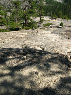
Trail location and construction materials are chosen to counter these powerful forces of natural trail destruction. High Sierra trails are generally constructed out of the abundant granite these mountains are noted for.
Granite trail construction, when executed over decades, even a century in some places now, can result in trails eventually disappearing under the fine granite rock work of generations of trail crew. The trail literally becomes paved in granite. This is mostly an issue in the high traffic parks on famous routes. I'm thinking Yosemite. The more obscure routes in less popular forests don't have to worry about this fate. In fact, decades of cutbacks in funding to the National Forests have brought a long slow decline in average trail conditions up and down the Sierra Crest.
That's good if you are an expert looking for challenging adventure, bad if you are an average backpacker expecting clear trails.
Besides a well maintained trail bed and the removal of obstacles, maintained trails are marked with regular ducks and blazes, and the major trail junctions are generally marked with informative sign posts.
The further we get off of the main popular maintained trails the longer is the time between trail crew visits. This means we will experience a wider range of conditions on remote maintained trails than on heavily used popular trails.
Unmaintained Trail
Unmaintained Trail: We cross two sections of unmaintained trail hiking the Tahoe to Yosemite Trail. Unmaintained trail sections can contain a wide variety of trail conditions. Conditions can range from encountering sections of perfect trail to extended lengths with no indications of trail or any indications of route whatsoever.
Though not maintained, on "unmaintained" trails we expect to find that elements of the original maintained trail are marginally visible. The trailbed is still occasionally visible or findable between various lengths which have reverted to a natural state. Great lengths of unmaintained trail may have been swept away by the seasonal powers of nature, buried under tree and snag falls, overgrown and melted into wet meadow. Old degraded ducks, blazes, and worn old trailbed fading out under forest floor litter may be the best parts of an unmaintained trail. The worse parts are degrading into, or have already become route.
Use Trail
Use Trail is the unmaintained remnant of a maintained trail. Use Trail is kept in existence by its protected position in the terrain and its continued light use by backpackers and animals. Though bits of Use Trail may not offer us much distance hiking on good "trail" conditions, its utility is as much in informing us we are actually following the correct route through the terrain as offering easy walking.
Route
Route: My definition of a route are locations where conditions make navigation dependent upon the observations of the hiker, rather than the presence of continuous trail, to maintain the proper course across the terrain.
After a decade or two of unmaintained status with light backpacker traffic the trailbed of an unmaintained trail will revert to Route status. The trailbed has melted into the terrain, though slight indications of its presence may still exist as isolated bits of Use Trail. These lonely remnants of the trailbed are maintained by animal traffic and these trailbed remnants no longer connect to other bits of ancient trailbed as the animals' purposes and destinations differ from ours. Yet a viable route through the terrain remains, but crossing these sections of terrain are dependent upon our observation, our on the ground route finding skills, and our broader navigation skills.
Crossing a route cannot be made by following trail, ducks, or blazes, but is based on your route finding and navigation skills.
A route requires you self-navigate without indications of trailbed, ducks, or blazes.
Top of Page
Along the Trail
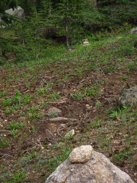
Ducks
Pile of stacked rocks of different color to designate trail route.
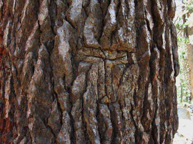
Blaze
Regular pattern cut in tree to mark trail route. Traditionally a square below a rectangle. Below is one of the pre-National Park blazes made by US Calvary marking Yosemite trails.
Wild Ducks
are what I call the stacked rocks that mark key points along a route. Wild Ducks are solitary ducks along an otherwise unmarked, or minimally marked, route. Wild Ducks mark key locations along the route such as fords and turns along our route rather than following and marking the position of a continuous trail. Wild ducks are located at key positions along the route rather than leading us on at regular intervals.
Above a wild duck along the Clarks Fork above the upper "waterslide" waterfall.
Other Signs
Not many man-made trail markers persist over the long term without being maintained. Once a trail reverts into the terrain and the blazes are overgrown, we are just left with the basics, which is just the natural route through the terrain.
Cut Wood
If there was once a trail, we will see cut logs and timber, from when the trail was maintained. When all else fails, ancient cut logs reassure us that someone once cleared a trail... until even these very persistent remnants of human contact eventually melt into the terrain.
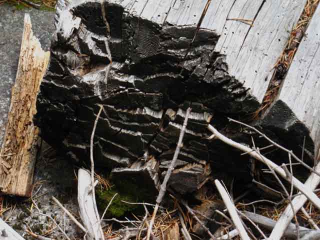
Old Human Powered Axe Work along unmaintained trail through Summit City Creek on the Tahoe to Yosemite Trail.
Burnished Rock
Constant foot and stock traffic will polish, or burnish granite, leaving an enduring sign
of previous human use long after the traffic ends.
Burnished rock above Camp Irene.
Top of Page
Wilderness Area
Definitions
The Official Record
The Wilderness Act of 1964
AN ACT
To establish a National Wilderness Preservation System for the permanent good of the whole people, and for other purposes.
Be it enacted by the Senate and House of Representatives of the United States of America in Congress assembled,
SHORT TITLE
Section 1. This Act may be cited as the "Wilderness Act".
WILDERNESS SYSTEM ESTABLISHED STATEMENT OF POLICY
Sec. 2. (a) In order to assure that an increasing population, accompanied by expanding settlement and growing mechanization, does not occupy and modify all areas within the United States and its possessions, leaving no lands designated for preservation and protection in their natural condition, it is hereby declared to be the policy of the Congress to secure for the American people of present and future generations the benefits of an enduring resource of wilderness. For this purpose there is hereby established a National Wilderness Preservation System to be composed of federally owned areas designated by Congress as "wilderness areas", and these shall be administered for the use and enjoyment of the American people in such manner as will leave them unimpaired for future use as wilderness, and so as to provide for the protection of these areas, the preservation of their wilderness character, and for the gathering and dissemination of information regarding their use and enjoyment as wilderness; and no Federal lands shall be designated as "wilderness areas" except as provided for in this Act or by a subsequent Act.
Wilderness.net
National Park Service
BUREAU OF LAND MANAGEMENT
Top of Page |
Trail Rating Difficulty Standards
Trail ratings are broken into three levels of difficulty, composed of
HARD, INTERMEDIATE, and EASY.
Each difficulty level is further broken down into 1, 2, and 3, with "Easy 1" being the hardest level of Easy, while "Easy 3" is the easiest trail rating possible.
"Hard 1" is the most difficult trail rating possible.
These trail ratings are based on three considerations.
First, the altitude, angle of attack, and duration of the exertion.
Second, the ratings are contrasted against the hiker's level of physical preparation and conditioning. Third is the level of trail maintenance or the trail itself.
The combination of these three environmental factors (altitude, angle of attack, and duration), when contrasted against our level of fitness, gives us a very good idea how we are going to respond to a rated trail, if we have objectively rated the difficulties of the route, and honestly assessed our level of fitness.
The goal here is to balance capabilities against objectives that expectations and plans remain within reasonable constraints, making results attainable without extreme duress, danger, or pain.
Or at least within our expected levels of duress, danger, and pain.
...
Trail Difficulty Rating
Hard
1, 2 & 3
Intermediate
1, 2 & 3
Easy
1, 2 & 3
...
Trail Difficulty Rating
rated by
Hiker Fitness Level
Level 1
HARD FITNESS
The highest level of hiker fitness is the capacity to jog 7 miles with a 700 foot altitude gain 4 times a week.
This is complimented by heavy weightlifting during non-jogging days.
Trail Capacity
Able to maintain two miles per hour on Hard- 1 Level Trails.
Level 2
INTERMEDIATE FITNESS
The second level of fitness is the capacity to jog 3.5 miles with a 350 foot altitude gain 4 times a week.
This is complimented by moderate weightlifting during non-jogging days.
Trail Capacity
Able to maintain two miles per hour on Intermediate-1 Level Trails.
Level 3
EASY FITNESS
The third level of fitness is the capability to walk 3.5 miles with a 700 foot altitude gain 4 times a week.
This is complimented by moderate weightlifting during non-jogging days.
Trail Capacity
Able to maintain two miles per hour on Easy-1 Level Trails.
Top of Page
Adjustment Factors
How this works
Running the Dogs
When a hiker in conditioning level #1, the highest fitness level, encounters a "Hard 1" trail, the highest level of trail difficulty, they will maintain a two mile per hour pace. We will be working like a dog, but we will be able to maintain pace on the most difficult terrain. We have our full observation & analysis tools at our disposal, under heavy load.
When a hiker in conditioning level #2, the intermediate level, hits a "Hard 1" rated trail, we will be capable of maintaining a one mile per hour pace. Though working just as hard as a hiker in conditioning level 1, the level 2 hiker will be on "survival mode," capable of maintaining this reduced pace, but that's about it. We will have limited observation, now focused mostly on the trail, rather than the surrounding terrain, due to duress. Analysis is still good, when we stop to think about it...
When a hiker in conditioning level #3, the lowest level of conditioning, encounters a "Hard 1" trail, we will be forced down to "x" amount of steps before being forced to pause and recover both breath and muscle strength. We will be hurting. Survival mode will be induced. We cannot really effectively observe the terrain nor vistas, analyze, nor enjoy them, due to depth of our energy deficit and metabolic loading. It's a sad sight...
The "Ball" is in Our Hands
The same degree of degradation or improvement of our subjective experience will be reflecting degradations or improvements in our fitness.
Our pain will halve and our performance double if we improve our fitness level from the Easy to Intermediate levels. They will respectively double and halve if our fitness degrades from Intermediate to Easy.
How to Cook Frogs
This tells us two things. First, fitness is variable. Second, knowledge of our actual fitness level is vital for planning successful backpacking trips.
Honestly, I can get the same performance out of you the hard way or the easy way. I can put you "under the gun," and you will likely perform and succeed, but under great stress and pain.
Or I can train you up slowly.
The difference between the two methods is subjective experience and injury. The "under the gun" approach to fitness is painful and subject to injury. The slow-cooking method has a much more manageable pain profile and is much less susceptible to injury.
Which method you choose to approach Nature should be a product of making an informed decision, not the result of a lack of information.
I have seen folks throw themselves out of the frying pan into the fire without even knowing they were about to get burned. Don't be that fool. Rate yourself honestly and match your trips to your real fitness.
Other
Factors
Our level of fitness against the level of trail difficulty are the basic physical parameters defining the difficulty of our trip. There are others.
Acclimation to altitude is the primary factor that will affect our perception of trail difficulty beyond fitness and terrain.
Pack weight is also a crucial factor. The weight of a 15 day food load will make a top conditioned backpacker perform like an intermediate conditioned backpacker. An intermediate hiker will slow to rookie speeds under this massive load, and this same load will make an under conditioned backpacker suffer in all aspects of existence.
Thus weight-lifting/upper body fitness is listed as a factor in rating trails. Pack stress on the upper body is almost as significant a factor as pack stress is on our lower body.
It's hard to have a good time when foot and shoulder pain are the external physical bookends expressing the deeper lack of fitness and preparation internally crushing our metabolism.
Angle of Ascent. Our first steps starting a high elevation backpacking trip with a heavy pack making a steep climb to our first pass ties all our physical stresses together providing us with a stark analysis of the suitability of our preparations.
Trip choice is vital. If we bite off more than we can chew or set unreasonable objectives for our level of skills and fitness we can put ourselves into real trouble. Bad trip selection subjects us to unnecessary suffering while risking injury.
Think About It
Therefore, if you are relatively inexperienced and unconditioned, you SHOULD NOT begin your backpacking career with Long Distance High Sierra Backpacking.
You should start by building gear and fitness in a logical manner. Bring your gear and fitness out for car camping and day hiking tests, building to an overnighter or two nighter backpacking trips up some big ridges that do not involve very high altitudes.
Once you've developed a perspective on your fitness, skills, and gear status you can move up to short-distance high altitude trips. In the meantime, you have worked out your boots, equipment, insulation, and food preferences. Working these issues out before beginning a long distance backpacking trip is an expression of wisdom.
Now you are ready for some long distance, high altitude, High Sierra backpacking.
Depending on how we've progressed with our skills and fitness issues during our short backpacking trips, we should now consider anything from a 30 to 75 mile High Sierra backpacking trip.
This does not just apply to new backpackers, but also to those of us who are more experienced, but recovering from injury or extended periods of fat-assednesss.
Let's bring ourselves up to speed logically and gracefully by weaving together our expanding experience into blossoming health and understanding.
Top of Page |
Tahoe to Whitney Trail Rating System
UTILITY
The Tahoe to Whitney rating system is not like most other systems attempting to rate degrees of trail difficulty. We define the objective measure of trail difficulty against various levels of backpacker fitness to find where a hiker's experiences will fit on a scale of subjective experiences.
In very real terms you are the center of your own reality, centering the universe around you as well, and personally liable for all the good and bad experiences your "center" comes with. Finding your own properly balanced position between the positive and negative of your position in the reality of our universe is of vital importance.
This requires our system identify trail difficulty both physically and subjectively in terms of caloric demands, ie, as different levels of "work."
Each hiker using this trail rating system is required to know what level of work they are capable of performing and exactly how they subjectively feel performing that level of work.
This trail rating system requires your direct involvement.
Even better, the factors this trail rating system uses are themselves very informative. The key fact driving this system is that subjective experience is linked to fitness. This is true everywhere in the Sierra.
Our ability to burn calories over hours, days, and weeks is the key to this system.
Rating terrain, as in identifying an objective scale of terrain difficulty, is not the goal of the Tahoe to Whitney rating system. We are looking for how much energy a given piece of terrain demands, against an individual's capacity to withstand that metabolic loading.
If it kills you to do it once, you are not going to like endless ascending ridges...
Thus the Tahoe to Whitney rating system has the potential to be simultaneously more and less precise than the classic trail rating systems.
This system is more precise if you are honest about your fitness. This system also has the potential to be wildly imprecise in proportion to a hiker's ability to lie to themselves and actually create a fantasy world of unreasonable expectations about experience in the High Sierra and what it takes to hike the High Sierra safely.
Delusion can be Deadly.
As a trail guide Tahoe to Whitney is mostly confined to Class 1 and 2 trails. There's only a little Class 3 trail described on the guide, and all cross country routes described on this guide are well-discused.
Classic Trail Rating Systems
Class 1:
Trail
Class 2:
Cross Country
Class 3:
Cross Country using Hands
Class 4:
Cross Country using Hands with fall producing serious injury or death.
Wisdom has us thinking about protection.
Class 5:
Climbing.
Top of Page |
The Northern Sierra
PCT differences from TYT
Unmaintained TYT trail sections status reports
Trails, Trail Work and Trail Crew Forum
THIS PAGE IS UNDER CONSTRUCTION: STAY TUNED FOR MUCH MORE!
COME ON BACK NOW, 'YA HEAR?
This the the DRAFT EDITION.
Let me know what you think, or how I can assist.
Contact
Alex Wierbinski
Next page
Trail and Camp Skills
Top of Page |