


Backpacking
Meeks Bay Trailhead
to
Echo Summit Trailhead
Desolation Wilderness Topo Backpacking Map
The Big Picture
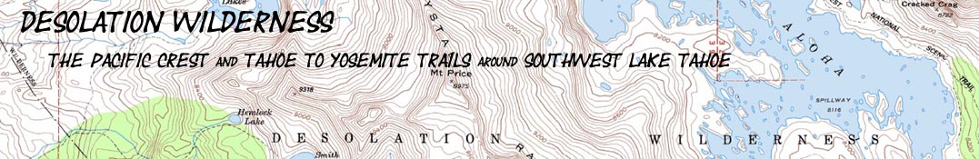
Hiking Map of the The Tahoe to Yosemite Trail through Desolation Wilderness
Two USGS 30 minute Topo Backpacking Maps

| Tahoe to Yosemite Trail MAPS and MILES |
TRAIL GUIDE | Tahoe to Whitney Indexes |
SOUTHBOUND: NORTH SIERRA PCT-TYT Topo Maps |
More Miles and Elevations |
Weather, Map Data | ||||||||||||||||
| MAP INDEX Meeks Bay to Echo Summit |
MAP INDEX SOUTH |
Miles and Elevations Meeks Bay to Echo Summit |
ALL MAPS INDEX | Section Meeks Bay to Echo Summit |
Page Meeks Bay |
Guide |
All Miles Tahoe to Whitney |
All Maps Tahoe to Whitney |
Meiss |
CPMA |
Carson Gap to Lake Alpine TYT |
Carson Gap to Ebbetts Pass PCT |
Carson Gap to Lake Alpine TYT |
Carson Pass to Ebbetts Pass PCT |
|||||||
| Tahoe to Yosemite Trail Maps and Mileages |
TRAIL GUIDE | Indexes | MAPS | Miles and Elevations | Weather, Map Data | ||||||||||||||||
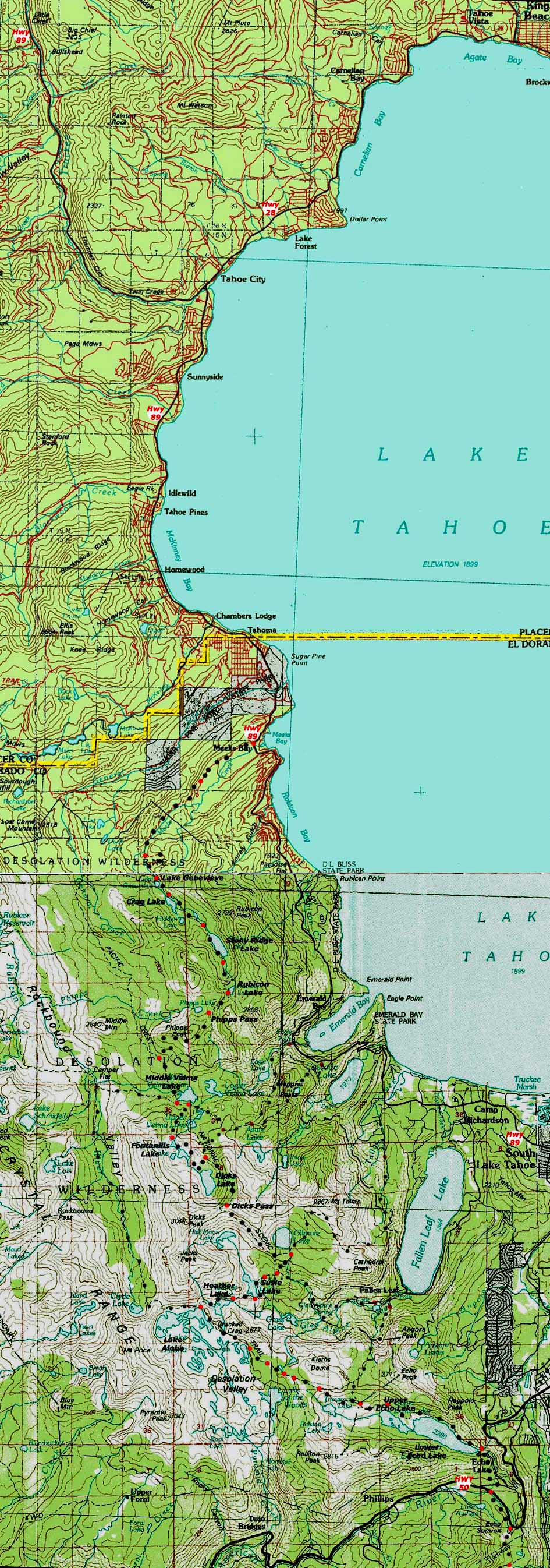
30.71 miles from Meeks Bay Trailead to Echo Summit Trailead.
| Click BLACK DOTS for Detailed Maps |
Click RED DOTS for Trail Guide Information |
| ALL DESOLATION WILDERNESS |
North Desolation Wilderness | Meeks Bay to Phipps Pass | Phipps Pass to Lower Echo Lake |
|
| ALL DESOLATION WILDERNESS |
North Desolation Wilderness | Meeks Bay to Phipps Pass | Phipps Pass to Lower Echo Lake |
| Road and Trailhead access to South Lake Tahoe |
||||
| Three Excellent Representative Trailheads Highways 50 and 89 Meeks Bay, Echo Summit and South Upper Truckee Trailheads |
South Lake Tahoe Resources Highways 50 & 89 |
|||
More
|
||||
Meiss Country Roadless Area
South of
Desolation Wilderness
Echo Lake to Echo Summit 7.5 map Echo Summit to Carson Pass 7.5 map Echo Summit to Carson Pass 30 min map
| This Location The Tahoe to Yosemite, Tahoe Rim, and Pacific Crest Trails through Desolation Wilderness |
|||||
Main Features: Meeks Bay is the trail head for the Classic Tahoe to Yosemite Trail, and an excellent entry point into the Desolation Wilderness for short and medium distance backpackers as well. This map depicts the Tahoe to Yosemite trail from its Meeks Bay Trail head on Highway 89 to the Echo Summit on Highway 50. 11.5 miles South out of Meeks Bay the Tahoe Yosemite Trail route meets up with the Pacific Crest and Tahoe Rim Trails at a junction just Southwest of Phipps Pass and .85 of a mile North of Middle Velma Lake. From there our three combined trails hike South through the length of the Desolation Wilderness. The marked route of the Tahoe to Yosemite Trail on the above topo hiking maps is linked to ten underlaying detailed topo hiking maps. These maps are in turn linked to underlaying trail guide pages along with more maps and miles information. You will find a linked list of major points along this section of our trail below. Click along the route on the map above near Lake Genevieve for the little Meeks Bay to Phipps Pass section of topo map. Click Meeks Bay for the North Desolation Topo Hiking Map. Likewise, clicking near Phipps Pass brings a detailed map covering the trail down to Middle Velma, Fontanillis and Dicks Lakes, as well as Dicks Pass. Another click South of Dicks Pass brings us a backpacking map covering Susie and Heather Lakes past Lake Aloha to the end of the Wilderness above the Echo Lakes. Around Lake Aloha and down to Echo Summit we have detailed sections of maps to give us a degree of familiarity with the terrain. This will help us plan our trips as well as impart a degree of familarity with the terrain. Explore the resources linked to the maps above. The underlaying detailed maps have red dots which are linked to trail guide pages covering that specific location on the trail. The trail guide pages have images, videos, miles, and elevations with written descriptions of the trails and terrain. Each page invites your input to add to the depth and range of the guide and forum. Note that we have many access trails to the main Pacific Crest and Tahoe to Yosemite Routes that span the Desolation Wilderness from trailheads off of Highway 89 between Meeks Bay and Fallen Leaf Lake. The Meeks Bay to Echo Lake route depicted above crosses the whole length of the Desolation Wilderness, yet you can use the series of trailheads along the West shore of Lake Tahoe to craft many fine loops or in and out backpacking trips into the heart of Desolation Wilderness. No matter where you begin your backpacking trip you will need to hike the main PCT-TYT to cover significant miles along the High Sierra Crest. That's where this long distance trail guide can help.
|
Specific |
|||
Mileages and Elevations Section Maps: Meeks Bay to Echo Summit Section Miles and Elevations: Meeks Bay to Echo Summit Meeks Bay to Echo Summit: 30.71 miles Meeks Bay up to Phipps Pass Topo Map: Meeks Bay to Lake Genevieve +2561 feet, 8.88 miles Location Elevation Mileage Start: Meeks Bay 6239 0 +1161 Lake Genevieve 7400 4.39 +40 .38 Crag Lake 7440 4.77 +120 .58 Hidden Lake Jnct 7560 5.35 +240 .68 N. side, Stony Ridge Lake 7800 6.03 -- .59 S. side, Stony Ridge 7800 6.62 +560 1.13 Rubicon Lake 8360 7.75 +40 .14 Grouse Lake Jnct 8400 7.89 +400 .94 Grouse Jnct 2 8800 8.73 0 .15 Phipps Pass 8800 8.88 Total elevation gain, Meeks to Phipps: 2561'
Backpacking Phipps Pass down to Middle Velma Lake Desolation Wilderness Topo Map: Phipps Pass to Lake Aloha- 880 feet, 3.44 miles Phipps Pass 8800 8.88 -720 2.62 PCT Junction 8080 11.5 -160 .82 Middle Velma Lake 7920 12.32
Backpacking Middle Velma up to Dicks Pass Desolation Wilderness Topo Map: Phipps Pass to Susie Lake+1430 feet, 4.51 miles Middle Velma Lake 7920 12.32 +40 .10 Velma Lakes Trail Jnct 7960 12.42 -- .27 Maggie Peak/Emrld Bay Jnct 7960 12.69 + 400 1.17 Fontanillis Lake N. side 8360 13.86 -- .67 Fontanillis Al camp #2 8360 14.53 +120 .65 Maggie Peak/Emrld Bay Jnct #2 8480 15.18 +910 1.65 Dicks Pass 9390 16.83
Backpacking Dicks Pass down to Susie Lake Desolation Wilderness -1590, 2.93 miles Topo Map: Phipps Pass to Lake AlohaDicks Pass 9390 16.83 -1090 1.33 Gilmore Lake Jnct 8300 18.16 -180 .59 Hlf Moon/Gln Alpine Jnct 8120 18.75 -240 .30 Glen Alpine Jnct 2 7880 19.05 -80 .31 E. side Susie Lake 7800 19.36 -- .40 W. side Susie Lake 7800 19.76
Susie Lake to the North side of Lake Aloha Topo Map: Phipps Pass to Lake Aloha+320 feet, 1.4 miles W. side Susie Lake 7800 19.76 +120 .56 W. side Heather Lake 7920 20.32 +200 .84 N. Lake Aloha/Rubicon Jnct 8120 21.16
North side of Lake Aloha to Echo Summit End of the Desolation Wilderness Topo Map: Aloha LakeMap: Upper Echo Lake Map: Lower Echo Lake- 706 feet, 9.55 miles N. Lake Aloha/Rubicon Jnct 8120 21.16 +40 1.42 Lake of the Woods Jnct 8160 22.58 -80 .59 Lake Lucille/ Margery Jnct, (L) and Lake of the Woods (R) 8080 23.17 +240 .41 Lake Lucille/ Margery Jnct, #2 (L), and Lake of the Woods #4 (R) 8320 23.58 -80 .76 Traingle/Lilly Lakes Jnct 8240 24.34 -360 .68 Tamarack Lake Jnct 7880 25.02 -80 .46 Triangle/Lilly 2nd Jnct 7800 25.48 -280 .61 Boat Taxi Dock 7520 26.09 -106 2.62 Echo Lake Trail Head 7414 28.71 -37 2.00 Echo Summit Trail Head 7377 30.71 Miles and Elevations for the Next Trail Segment SOUTH Echo Summit to Carson Pass miles and Elevations |
Topo Map Information Map Names: Placerville and Truckee Calif., 1976 and 1977, 30x60 minute USGS Topographic Maps Compass Offset: Magnetic North is 18 degrees, 34 minutes East of True North
scale: 1:100 000 Contours: 50 meters
Backpacking permitting authority TahoeWhitney: Contact Information Feds: Lake Tahoe Basin Management Unit
National Forest: LTBMU Wilderness Area TahoeWhitney: Meiss Country Roadless Area Feds: Desolation Wilderness
Physical location Meeks Bay Trailhead and Highway 89 ON A CUSTOM GOOGLE MAP
Download Free USGS Topo MapsINSTRUCTIONS 1>Locate the position you need a map for on the google map. 2>CLICK the MARK POINTS mode. 3>Select the size of MAP FOOTPRINTS you wish to see. 4>CLICK the Map Footprint you want to down load. This will leave a red marker on that map footprint. 5>CLICK the red marker, and the maps available for you to download will appear. 6>Select and download the map you need. NOTE: These are "GEO Maps" that load in Adobe Reader with many cool functions. If you want to manipulate and print custom sections, you must first load the map into MS Paint before it can be manipulated in PhotoShop.
Back to the Meeks Bay trail head Back to the Tahoe to Alpine Trail Guide Index
|
||
North Topo Map: None South Topo Map: Echo Summit to Carson Gap
| Elevations | More Information | ||
Lake Tahoe Meeks Bay Trail head elevation change |
Trail Guide, Section: Meeks Bay to The Carson Gap Trail Guide, location: Meeks Bay Trailhead Google Map: All Lake Tahoe trailheads |
||