Killer Sunset from The Sisters, near Carson Pass Lake Tahoe to Mount Whitney: Your Backpacking Guide to the High Sierras
Mount Whitney from Sandy Meadow
The sisters Mount Whitney, in middle, from Sandy Meadow on the John Muir Trail Lost Keys Lake


High Sierra
Backpacking

Main
Trail Guide
TRAILHEAD


High Sierra
MAGAZINE


ALL BLOG


Trail Guide

Guide Index

Maps Index

Miles-Eleva

Permits

Resupply


Forums

All Blog

Trails Forum

Topics Forum


Sierra
Weather

ALL
High Sierra Weather

Weather
Notes

Northern
Sierra Weather

Central
Sierra Weather

Southern
Sierra Weather


Gear

Gear List

Gettin Started

Layering

Discussion

Testing yourself and gear

Member
Favorite Gear

Gear Reviews


top of page


Backpacking the High Sierra
LAKE TAHOE
to
MOUNT WHITNEY
USGS High Sierra Topo

Backpacking
MAP

INDEX


Languages

Translate


Trail Skills

The trail

Navigation

Camp skills

Paper Maps

Off the trail

Scrambling


Mountain
Safety

Safety Topics

Safety
Incidents

Mosquito Info

Skeeter News


Food

Resupply
FORUM

Food


Planning

40 Days to Whitney

Introduction Tahoe to Whitney

Introduction Tahoe-Yosemite


Trail Arts

Art of walking

Physical
Preperation


More
Information

Links


News
and
Science


Books


Trail Stories


Photo
Catagories


Social

Trail Culture


Groups


Terms and Conditions of Use


top of page

BACKPACKING MAPS
of the

Long Trails
along the
High Sierra Crest
from
Lake Tahoe to Mount Whitney


TYT - PCT - JMT
and
Much More


Mapping
the
High Altitude Trails
from
Tahoe to Whitney


North Sierra
Backpacking Maps

Trail Guide Under Construction
Sierra Nevada Maps

Lake
Tahoe
Basin
MAPS

TYT & PCT
Mokelumne
Wilderness
MAPS

TYT & PCT

Lake Alpine
Highway 4
MAP
Resupply


Lake Alpine
Highway 4
MAP
Resupply

Carson Iceberg
Wilderness
MAPS

TYT & PCT
Kennedy
Meadows

Highway 108
Resupply


Kennedy
Meadows

Highway 108
Resupply
Emigrant
Wilderness
&
North Yosemite
MAPS

TYT & PCT
Tuolumne Meadows
Resupply


Central Sierra
Backpacking Maps

Trail Guide Under Construction
Sierra Nevada Maps

Tuolumne
Meadows
to
Yosemite
Valley

JMT
Yosemite
Valley

Resupply
Yosemite
Valley

to
Lyell
Canyon


ALTERNATIVE
ROUTE
Tuolumne
Meadows
to
Reds
Meadow

JMT & PCT
Reds Meadow
Resupply


South Sierra
Backpacking Maps

Trail Guide Under Construction
Sierra Nevada Maps

Reds Meadow
Resupply
Reds
Meadow

to
Vermilion
Valley


JMT & PCT
ROUTE
Vermilion
Valley

Resupply


Reds Meadow
Resupply
Reds
Meadow

to
Vermilion
Valley via Fish Creek
ALTERNATIVE
ROUTE
Vermilion
Valley

Resupply


Vermilion
Valley

Resupply
Vermilion
Valley

to
Muir
Ranch


JMT & PCT
Muir
Ranch

Resupply
Muir
Ranch

to
Whitney
Portal


JMT & PCT
Whitney Portal
Doug's
Burgers

Trailhead Trail Section Index
PCT-TYT
JMT

The
Basic Line of High Sierra Trails across California
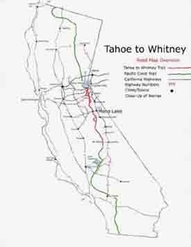
Tahoe to Whitney Trail laid out on a California map

The
BIG PICTURE

Lake Tahoe to Mount Whitney on a California Map.

The Pacific Crest Trail and High Altitude Sierra Nevada trails between Lake Tahoe and Mount Whitney, and within California.

Lake Tahoe to Mount Whitney
Red

Pacific Crest Trail
Green


Lake Tahoe to Mount Whitney
Maps

Overview

Detail

PCT & TYT
Lake Tahoe Basin
Backpacking
Maps


Trail Section One
Lake Tahoe Basin
Hiking Maps

Desolation Wilderness
and
Meiss Country Roadless Area
PCT and TYT
Maps

Desolation Wilderness Map
Desolation Wilderness
BACKPACKING MAP

RAW
DESOLATION WILDERNESS MAP

Click Map for Available Maps

TYT-PCT
MAPS

Desolation Wilderness
MAP LIST


South Tahoe Basin
Meiss Country Map
Meiss Country Roadless Area
BACKPACKING MAP


South Tahoe Basin
TYT-PCT
MAP LIST

Meiss Country Roadless Area
MAP LIST

top of page


ALL TAHOE BASIN MAPS

PCT & TYT
Mokelumne Wilderness
Backpacking Maps

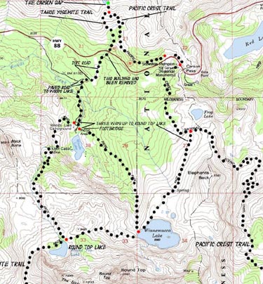
The Carson Gap Pacific Crest and Tahoe to Yosemite Trail Options
PCT and TYT South through the
Carson Pass Management Area

Trail Section Two
Carson Pass
to
Highway 4

The Mokelumne Wilderness

North End
El Dorado National Forest
Special Zone
Carson Pass Management Area
MAP
TYT-PCT


PCT & TYT
Mokelumne Wilderness
MAP
TYT-PCT
Click Red Dots for Location information,
Click the Black Dots for Detailed underlying Maps


Tahoe to Yosemite Trail
Carson Gap to Lake Alpine
TYT
MAP LIST


Pacific Crest Trail
Carson Pass to Ebbetts Pass
PCT
MAP LIST

top of page

Departing
the
Lake Tahoe Basin

The Tahoe to Yosemite and Pacific Crest Trails part company as we exit the Tahoe Basin through the Carson Gap, as we can see at the top of the map above.

The full-sized Carson Pass Region Topo Map above details our trail options where the Tahoe to Yosemite and Pacific Crest Trails split up exiting the Lake Tahoe Basin.

The TYT and PCT are our two route options between Highways 88 and 4. The TYT has a significant unmaintained segment of route along our trail.

There are many nice destinations for short trips around Carson Pass too, and extensive backpacking in remote areas of the Mokelumne Wilderness.

TYT
Backpacking Maps
for
CLASSIC
Lake Alpine Lodge Resupply
North and South on the TYT


Resupply Point #1

Lake Alpine Lodge

Highway 4

Lake Alpine Region
Backpacking Map

Click Red Dots for details


Lake Alpine Lodge
Backpacker Resupply Service

Both the Pacific Crest and Tahoe to Yosemite Trails cross Highway 4. The TYT crosses Higway 4 on the East side of Lake Alpine, 3/4 of a mile East of our Resupply Point at the Lake Alpine Lodge.
See the Maps above for the maps North into the Mokelumne Wilderness, and the maps below for the map South into the Carson Iceberg Wilderness.

Lake Alpine is sandwiched in between these two fine wilderness areas.

Ebbetts Pass, where the PCT crosses Highway 4 is about 15 miles East of Lake Alpine.


It's worth the hitch down!

Resupply Information and Local Resources

Lake Alpine Resort Bear Valley

top of page


Two Routes
across the
Carson Iceberg Wilderness
TYT & PCT
Backpacking Maps

The Tahoe to Yosemite and Pacific Crest Trails between Highway 4 and Highway 108

Both the TYT and PCT hike South through the Carson Iceberg Wilderness on their respective routes.

The Tahoe to Yosemite along the Western flank of the Sierra, the Pacific Crest Trail along the Eastern flank.

We can mix bits of both routes using the four trails that connect the TYT and PCT across the Carson Iceberg Wilderness.

Trail Section Three
Highway 4 to Highway 108

Encompassing
The Carson Iceberg Wilderness
Pacific Crest Trail and Tahoe to Yosemite Trail
Diverge


PCT & TYT
Carson Iceberg Wilderness
Backpacking Map


Tahoe to Yosemite Trail
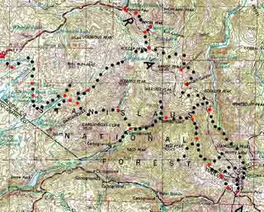
Lake Alpine to Saint Marys Pass
Western Carson Iceberg Wilderness
MAP LIST


Pacific Crest Trail Maps
Ebbetts Pass to Sonora Pass
Eastern Carson Iceberg Wilderness
MAP LIST

top of page


PCT and TYT
Backpacking Resupply

through the
CLASSIC
Kennedy Meadows Pack Station

Resupply Point #2

Kennedy Meadows Pack Station
and
Resort Highway 108

Kennedy Meadows Pack Station
BACKPACKER
Resupply and Resources
Information


for backpackers, day hikers, car campers, fishermen...

Sonora Pass Region
Backpacking Map

Click Red Dots for information, and Black dots for detailed maps of that location.

Tahoe to Yosemite Trail
Backpacking Map
South from Kennedy Meadows

Click the map's Labels and Arrows for adjacent maps, click the RED DOTS for detailed information.

Kennedy Meadows Pack Station is my favorite stop on the Tahoe to Yosemite Trail, and virtually mandatory for Pacific Crest and Tahoe to Yosemite Trail hikers. Why?

Because Kennedy Meadows roughly splits the 150 mile distance from Tuolumne Meadows to Highway 50 in the Lake Tahoe Basin.

Kennedy Meadows sits along the Tahoe to Yosemite Trail route up Summit Creek, which offers excellent local as well as long distance backpacking.

Kennedy Meadows Pack Station is 9 miles West of Sonora Pass.

Kennedy Meadows Pack Station
Official Website


Kennedy Meadows Backpacker
Resupply Information


Kennedy Meadows Pack Station
Contact Information


Stanislaus National Forest
Permit Information


top of page

PCT & TYT
Backpacking Maps
of the
Emigrant Wilderness
and

North Yosemite Backcountry
to

Tuolumne Meadows

Terrain North and South of Saint Marys and Sonora Passes.

Trail Section Four
Highway 108
to
Highway 120

Crossing
Emigrant Wilderness

into
North
Yosemite National Park

The Pacific Crest and Tahoe to Yosemite Trails

Diverge across Emigrant Wilderness
Converge entering North Yosemite


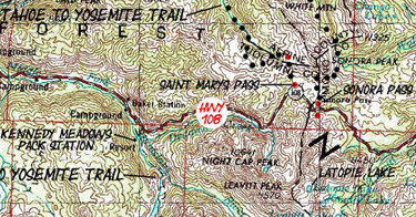
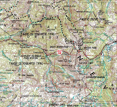
Sonora Pass Region
Backpacking Map

Kennedy Meadows, Sonora Pass,
Leavitt Lake and Meadow.


Tahoe to Yosemite Trail
Kennedy Meadows to Bond Pass
Emigrant Wilderness Backpacking Map

MAP LIST


Pacific Crest Trail
Sonora Pass to Bensen Lake
PCT South from Highway 108 Map
MAP LIST

top of page

The
Pleasures
of
Resupplying
at

Tuolumne Meadows

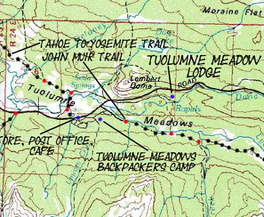
Tuolumne Meadows US Geological Service map.

Resupply Point #3

Tuolumne Meadows
Highway 120

Tuolumne Meadows
Backpacker Map

Tuolumne Meadows Resupply
Post Office, Grill,
and Store

Backpacking Permits
Yosemite National Park

top of page

Standard
JMT-PCT
South Yosemite
&
Ansel Adams Wilderness

Trail Section Five
Tuolumne Meadows

TO
RED'S MEADOW

Yosemite
and
Ansel Adams Wilderness
Standard JMT-PCT Routes


Index Map
Central Yosemite Map of Maps
Links to Detailed Maps
Click All Dots
Central & South Yosemite
Backpacking Map
Yosemite Vallety to TM to Island Pass


Map
Central Yosemite Map of Guide Pages
Links to Trail Guide Pages
Click Red Dots

Central & South Yosemite
Backpacking Map
Yosemite Vallety to TM to Island Pass


Ansel Adams Wilderness
Backpacking Map
Donohue Pass to Fish Valley


MAPS
  MAP LIST


Tuolumne Meadows

Central Yosemite

Ansel Adams Wilderness

 
Tuolumne Meadows
to
Reds Meadow
JMT Hiking Maps List


Backpacking Permits
JMT & PCT
Yosemite Permits
top of page
In Progress...Stay Tuned for More!
 
Alternative Route
The Golden Triangle
JMT
The Heart of Yosemite Valley Drainages

Tuolumne Meadows
TO
Yosemite Valley

Central Yosemite Wilderness
JMT Alternative Route, "Backwards"

Executing
"The Golden Triangle I"

TM to Valley

John Muir Trail Map
Central Yosemite
Happy Isles to Tuolume Meadows to Donohue Pass


DETAILED MAP
  LIST

Central Yosemite Wilderness
 
Tuolumne Meadows
to
Yosemite Valley
JMT Hiking Maps List

Backpacking Permits
JMT
Yosemite Permits
top of page
Tuolumne Meadows
Yosemite Valley
Backpacker Resupply
Yosemite Valley Resupply
The Golden Triangle
back to
Southbound
JMT
in
Lyell Canyon
Yosemite Wilderness Up the Merced River

Yosemite Valley
to the
JMT in Lyell Canyon
via
Merced Lake
and
Voglesang Pass

Central Yosemite Wilderness
JMT Alternative Route

"The Golden Triangle II"
Central Yosemite
Merced Lake to Lyell Canyon via Vogelsang


MAP   LIST

Central Yosemite
 
Yosemite Valley
to
Lyell Canyon
Maps List

Backpacking Permits
JMT
Yosemite Permits
top of page
 

Reds Meadow
and
Mammoth Lakes
JMT-PCT
CLASSIC
Backpacker Resupply Point

Resupply Point #4

Red's Meadow

Minaret Road

Mammoth Lakes


Reds Meadow and Mammoth Resupply Page


Reds Meadow-Mammoth Lakes
Comprehensive Forum Entry


Reds Meadow Website
Resupply Information

Standard
JMT-PCT
Reds Meadow
to
VVR
Route South

Trail Section Six
Red's Meadow

to
Vermillion Valley Resort

John Muir Wilderness
JMT-PCT

Backpacking Maps

Region Backpacking Map
Red's Meadow to Vermilion Valley


MAP
  LIST

Reds Meadow
to
Vermilion Valley
 
Reds Meadow
to
Vermilion Valley
Resort
JMT Hiking Maps List


Backpacking Permits
JMT & PCT

Inyo National Forest

Sierra National Forest

top of page
Alternative Route South
Reds Meadow
through
Fish Valley
to
VVR

Red's Meadow
to
Vermillion Valley Resort
via
Fish Valley

John Muir Wilderness
JMT-PCT

Backpacking Maps

Region Backpacking Map
(SAME AS ABOVE)


MAP
  LIST

John Muir
Wilderness
 
Reds Meadow
to
Vermilion Valley Resort
FISH VALLEY ROUTE
Hiking Maps List


Backpacking Permits
JMT & PCT

Inyo National Forest

Sierra National Forest

top of page
 

Vermilion Valley
Suck Ass
Backpacker Resupply

Resupply Point #5

Vermillion Valley Resort

Last Interaction:
VVR experienced a Total Failure to support a downed backpacker in trouble and need.

They insulted him, while injured!!!!!!!!

Thank god they are for sale!


Highway 168, Huntington Lake Road


Vermilion Valley Resort Resupply Page


Forum Entry


VVR Site: Resupply Information


VVR FOR SALE

Standard
JMT-PCT
Vermilion Valey
to

Muir Ranch

Trail Section Seven
Vermilion Valley

to
Muir Ranch

John Muir Wilderness
JMT-PCT

Backpacking Maps

Region Backpacking Map
Vermilion Valley to Muir Ranch


MAP   LIST

Vermilion Valley
to
Muir Ranch
 
Vermilion Valley
to
Muir Ranch
JMT Hiking Maps List

Backpacking Permits
JMT & PCT

Sierra National Forest


top of page


Muir Trail Ranch
CLASSIC
PCT & TYT
Backpacker Resupply

Resupply #6

Muir Ranch

A fine, quiet resupply experience.

No Road Access


Muir Ranch Resupply Page


Muir Ranch Website
Backpacker Information


Muir Ranch Website
Resupply Information

June through September: See Calendar
Accepted resupply packages for June 23 Pickup in 2014...

Muir Ranch Contact Information

Standard
PCT & TYT
Muir Ranch
to

Whitney Portal
A long pull

Trail Section Eight
Muir Ranch

to
Mount Whitney

Kings Canyon National Park
JMT-PCT

Backpacking Maps

Region Backpacking Map I
Muir Ranch to Bishop Pass


Region Backpacking Map II
Bishop Pass to the Whitney Portal


MAP
  LIST

Bishop Pass
to
Whitney Portal
 
Muir Ranch
to the
Whitney Portal
JMT Hiking Maps List

Backpacking Permits
JMT & PCT

Kings Canyon National Park


top of page


End of the Trail

Mount Whitney Portal
Lone Pine Resources

Doug's Portal Burgers
and
Backpacker's Hostel

Portal Road
down to
Hwy 395, Lone Pine

Lone Pine
Grocery, Cafes, Motels
&
Doug's Backpacker Hostel


Trailhead

Contact
Alex Wierbinski

top of page

Rock Lake Sunset, Tahoe to Yosemite Trail, Carson Iceberg Wilderness

Lake Tahoe to Mount Whitney

Your guide to backpacking the Sierra Crest, including the Tahoe to Yosemite, the Pacific Crest, and John Muir Trails

Rock Lake, Tahoe to Yosemite Trail, Carson Iceberg Wilderness
© Lake Tahoe to Mount Whitney: Crown Jewel of the Pacific Crest Trail