


Regional Topo Map
Lake Alpine/Ebbetts Pass to Sonora Pass

previous MAP page: whole trail map index
next MAP page, Map Section Index: Lake Alpine/Ebbetts Pass to Sonora Pass
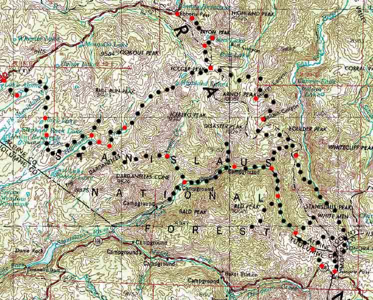 |
Main Feature(s): Though not highly detailed, this map will give you and indication of the variety of routes you can pursue through the Carson-Iceberg. The Pacific Crest and Tahoe to Yosemite only make up two of many potential routes. Individual maps within the following Lake Alpine/Ebbetts Pass to Sonora Pass section maps will provide much greater detail. There are inaccuracies in this map. First, Spicer Reservoir now extends up Highland Creek to the Highland Trail's junction with Bull Canyon Trail on the Tahoe to Yosemite Trail. Second, this map had no trail markings, and I have roughly laid out the main trail routes and trail junctions. See the Lake Alpine/Ebbetts pass to Sonora Pass section maps for for highly detailed mapping of the various routes. |
This page is under construction!
next MAP page, Map Section Index: Lake Alpine/Ebbetts Pass to Sonora Pass
previous MAP page: whole trail map index
Mileages (Not Yet, I'll get here.)
Lake Gene: 2. miles
The e: 38 miles
The Pacific Crest Trail : .85 miles
Total Miles: ?.1 miles
back to Alpine Lake to Sonora Pass maps index
back to Lake Alpine to Sonora Pass Trail Guide Index
back to highway 4 trail heads
Map Name: Walker Lake 1x2
Backpacking permitting authorities: Stanislaus and Toiyabe
National Forests in map section
A rough line drawn across the Sierra Crest from Ebbetts Pass to Sonora Pass divides the Stanislaus National Forest on the Western Flank of the Sierras from the Toiyabe National Forest on the Eastern Flank of the Sierras.
Wilderness Area: both routes cut through the heart of The Carson-Iceberg Wilderness, which is split between the Stanislaus and Toyabe National forests.Physical location: Between Highways 4 and 108 along the Sierra Crest
scale: 1:250,000
total trail mileage: not yet worked
base elevations
Lake Alpine: variable, call it 7388 feet
Sonora Pass: 9624 feet
Trail Guide, Section: Highway 4 to Sonora Pass
Trail Guide, Segment: Alpine or Ebbetts to Wolf Pass
Google Map, Region
Map Credit: U.S. Geological Survey, Department of the Interior/USGS
(use search term "XXX," and "Address" search type to locate this USGS map)
USGS Topographic Map Information
next map last map
Comments on this