

All
Central and South Yosemite
Topo
BACKPACKING TRAIL MAP
The Golden Triangle,
The
Sierra Crest,
Cathedral Range,
and
Clarks Range
Pacific Crest Trail and John Muir Trail
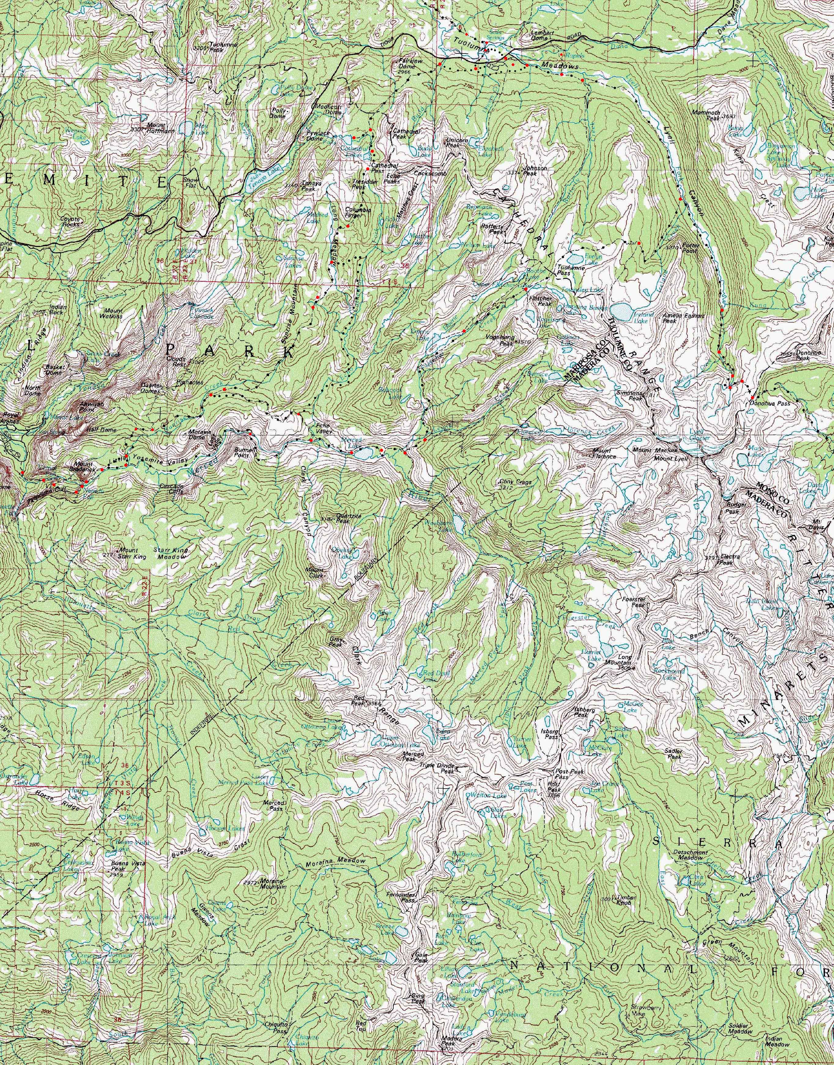
Region Trail and Terrain Map
One
BIG
30 minute USGS Backpacking Map

Maps |
30 min |
30 min |
Miles |
Miles |
Miles and Elevations TYT-PCT NORTH Sonora Pass to Tuolumne Meadows |
Trail Guide PAGE Tuolumne Meadows to Cathedral Lake |
7.5 minute |
Click |
WEATHER |
RESUPPLY |
PERMITS |
Map Information |
Crossing
The Heart of Yosemite
3 DETAILED MAPS UNDER ONE
| 1 Tuolumne Meadows 7.5 minute Hiking Map |
2 Cathedral Pass to Yosemite Valley to Merced Lake 7.5 minute Hiking Map |
3 Merced Lake to Island Pass via Vogelsang 7.5 minute Hiking Map |
| North Classic TYT-PCT Virginia Canyon to Tuolumne Meadows |
Click To Find 3 Detailed Trail Maps |
South |

|
| North Virginia Canyon to Tuolumne Meadows |
Click the MAP |
THESE THREE
Yosemite Trail Maps
| Tuolumne Meadows 7.5 minute Hiking Map |
Cathedral Pass to Yosemite Valley to Merced Lake 7.5 minute Hiking Map |
Merced Lake to Island Pass via Vogelsang 7.5 minute Hiking Map |
Big
Central Yosemite Wilderness
30 minute Hiking Map
Mapology |
||||
MAP NOTE What's important for our general reference purpose is that each side of a square is 1000 meters, or a Kilometer. From my point of view that is 1093.6 yards or .62 of a mile. Diagonal: 1414.22 meters, if my trig is correct. That converts the diagonal distance into 4,639.8 feet or .88 of a mile.
|
next map: last map:
| Elevations | More Information | ||
Tuolumne Falls Tuolumne Meadows Cathedral Pass Vogelsang |
|||
Map Credit |
||
U.S. Geological Survey, Department of the Interior I love the USGS, as you can see from the Tahoe to Whitney Maps. I also dig the NWS, as you can see from our Weather Page. We gotta know the terrain under our feet, and the weather in the sky. These are the basics. In that spirit, let's set you up with the USGS maps sufficient to plan and execute your High Sierra Backpacking Trip with a set of custom backpacking maps. In fact, we can use the USGS to set us up to plan and hike anywhere in the US of A. Move the Map to the Sierras. Or your favorite backpacking spot in the US of A. Navigate the map to the area you wish to locate maps. Click "Mark Point" in the options to see the USGS map grid of the various scaled maps. Select the maps that will help you plan and execute your backpacking trip, set up a directory on your computer named for the trip or location of the maps, and begin downloading those suckers. Open your USGS maps with Adobe Reader. But first, we have to "unzip" the maps. I use 7zip. Custom Maps Printing At least one reader of Tahoe to Whitney has copied and printed out Tahoe to Whitney Maps with success.
That is totally cool for personal and non-profit uses. |