


Reds Meadow to Vermilion Valley Resort Backpacking Map
Pacific Crest and John Muir Trails
Four 7.5 minute USGS Topographic Backpacking Maps

Maps Index |
Guide Index |
7.5 min |
7.5 min |
Miles |
Miles |
Trail Guide PAGE Reds Meadow to Island Crossing |
30 minute |
Click |
WEATHER |
RESUPPLY |
PERMITS |
maps information |
Backpacking Map of US hiking South out of the Ansel Adams Wilderness of the Inyo National Forest and into the John Muir Wilderness of the Sierra NF
| North: Donohue Pass to Reds Meadow | Click Red Dots |
 |
| North: Donohue Pass to Reds Meadow | Click Red Dots |
Location Information |
||||
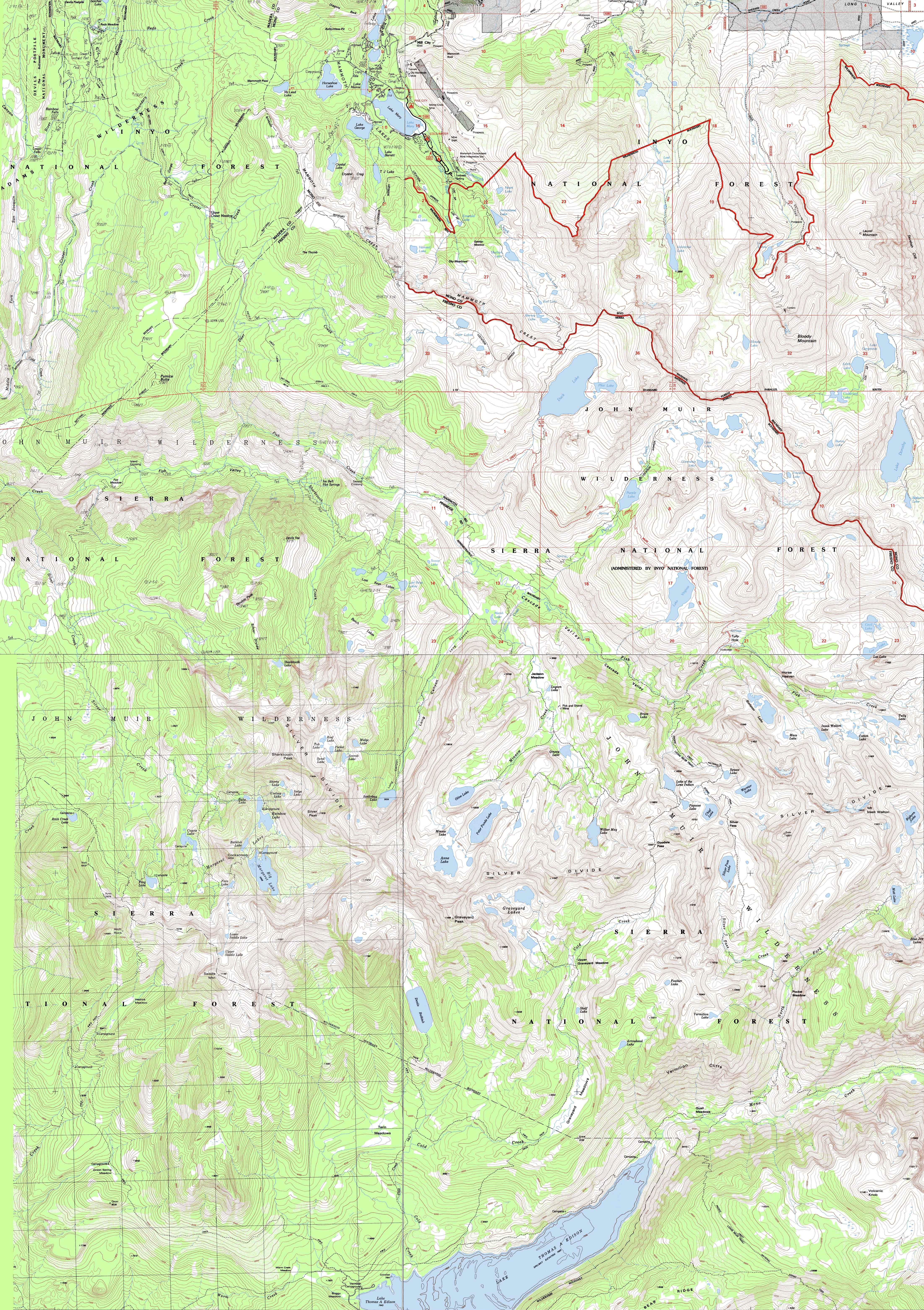
Main Features and Location Notes Draft Edition; Much more information coming! Mammoth Lakes To our Northwest (previous map) and West we've the stunning beauties of the North end of the Ritter Range running up to and kissing the bottom of the Cathedral Range across the top of the Ansel Adams Wilderness of the Inyo National Forest. To our South and Southwest (map above) we have the JMT tracking across a series of lakes nestled in the undulations acorss the top of the North edge of the rim of Fish Valley. The John Muir Trail brings us to a deep descent preparing us for the steep climb over the Silver Divide and subsequent descent to the VVR ferry on the Northeast end of Lake Thomas Edison. The map above also shows an alternative route that walks us all the way into the Vermilion Valley Resort and our next resupply. Following the trail South from Reds Meadow into Fish Valley brings us to Iva Bell Hot Springs. Iva Bell is about the highest degree of quality I've seen at natural hot springs anywhere along the trails. Heck, I've got to compare it favorably with a lot of "improved" hot spring up and down Highway 395. The reason is that Iva Bell has three levels of hot springs running up from its base, each with a nice campsite or two. Each hot spring climbing the mountainside gets progressively hotter, with the upper spring running between 98 and 104 degrees. A cool creek runs 50 yards away from the campsite. Iva Bell Hot Springs is a wonderful place. I have traditionally followed up my typical two-night stay at Iva Bell with an attempt at a big miles day. I shoot for making the whole hike from Iva Bell Hot Springs to Vermilion Valley. I will dig the miles I measured during the trips out of my notes as I continue to build this Southern end of the guide, but I think Butch told me it was 28 miles. If I feel good and the day is going well I will try to make it in one long day. Though the route of the John Muir Trail past Deer, Duck, Purple, and especially Lake Virginia is nice, the alternative route through Fish Valley is much quieter and less-traveled. Iva Bell Hot Springs can get some Summer weekend backpacker traffic coming out of Mammoth Lakes, but I've always encountered a very wide variety of very cool backpackers out there. Nonetheless, I still try to time my stay at Iva Bell for mid-week, if possible, to give myself the best chances of snagging the upper campsite & proximity to its very hot spring. Inyo National Forest MAP NOTE What's important for our general reference purpose is that each side of a square is 1000 meters, or a Kilometer. From my point of view that is 1000 yards or .62 of a mile. Diagonal: 1414.22 meters, if my trig is correct. That converts into 4,639.8 feet or .88 of a mile.
top of page |
Mapping, Mileage, |
|
|
Northwestern Map Southwestern Map
Northeastern Map Southeastern Map
Compass Offset
scale Contours Backpacking permitting authorityNational Forests Wilderness Area Physical location |
North map: Donohue Pass to Reds Meadow South map: Vermilion Valley to Muir Ranch
| Elevations | More Information | ||
Tuolumne Meadows: feet Yosemite Valley: feet elevation rise: meters, or feet |
|||
Map Credit |
||
U.S. Geological Survey, Department of the Interior I love the USGS, as you can see from the Tahoe to Whitney Maps. I also dig the NWS, as you can see from our Weather Page. We gotta know the terrain under our feet, the weather in the sky, and the stars above. These are the basics. In that spirit, let's set you up with the USGS maps sufficient to plan and execute your High Sierra Backpacking Trip with a set of custom backpacking maps. Let's put ourselves on the terain through the weather under the stars, and life will be good. In fact, we can use the USGS to set us up to plan and hike anywhere in the US of A. Move the Map to the Sierras. Or your favorite backpacking spot in the US of A. Navigate the map to the area you wish to locate maps. Click "Mark Point" in the options to see the USGS map grid of the various scaled maps. Select the maps that will help you plan and execute your backpacking trip, set up a directory on your computer named for the trip or location of the maps, and begin downloading those suckers. Open your USGS maps with Adobe Reader. But first, we have to "unzip" the maps. I use 7zip. Custom Maps Printing At least one reader of Tahoe to Whitney has copied and printed out Tahoe to Whitney Maps with success.
Decimal-Degree Conversion Tool Using TW maps is totally cool for personal and non-profit uses. |