

The Trails
Guide
Maps
Miles/Ele
Permits
Resupply
Forum
Current Weather Conditions
Weather Notes
Northern High Sierras
Central High Sierras
Southern High Sierras
Gear
Gear List
Gettin Started
Layering
Discussion
Testing yourself and your gear
Gear Reviews
Tuolumne Meadows
to
Yosemite Valley
The John Muir Trail
John Muir Trail Backpacking Maps
Languages
Translate
Trail Arts
The art of walking
Physical Preperation
Trail Skills
The trail
Off the trail
Scrambling
Maps
Navigation
Camp skills
Food
Resupply
Food
Other
Photo Catagories
Trail Stories
Trail Culture
News and Science
Links
Groups
Books
MAP |
MAP |
REGION |
ALL |
GUIDE |
GUIDE |
GUIDE |
ALL |
MILES |
MILES |
ALL MILES INDEX |
Trail Section The John Muir Trail NOTE
|
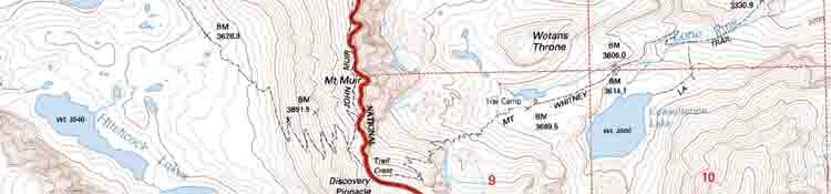
Topo Hiking Maps for Tuolumne Meadows to Yosemite Valley |
||
7.5 minute
Tuolumne Meadows Region
Yosemite Valley & Central Yosemite
South Yosemite Backpacking Map
|
30 minute
Central
|
|
| > Forum < | ||
| ROUTE OPTIONS NOTE
Hiking South from Lake Tahoe to Mount Whitney we've planned and written "The Golden Triangle" into our itinerary. It adds maybe another five or six days to the duration and maybe an additional sixtly miles of distance and five thousand feet of climbing. A "standard" Tahoe to Whitney backpacking trip would end our hike South along the combined Tahoe to Yosemite and Pacific Crest Trail at Tuolumne Meadows where we would pick up the combined routes of the John Muir and Pacific Crest Trails. Here we turn down the John Muir Trail to follow it down to its start point in Yosemite Valley. After checking out the weirdness and beauty in the Valley we will re-enter the John Muir Trail through Happy Isles up to Little Yosemite Valley, where we will break off the JMT. We are seeking a different way back to the Sierra Crest than re-tracing our steps back up the John Muir Trail to Tuolumne Meadows. We'll continue up the Merced River past Little Yosemite to hike over Vogelsang to reconnect with the Southbound JMT-PCT in Lyell Canyon a few miles South of Tuolumne Meadows. |
| NORTH Map Index Sonora Pass to Tuolumne Meadows |
SOUTH |
Backpacking Map
|
||||||||
Backpacking Map Information and Instruction
USGS MAP LOCATOR Free USGS Maps for Downloading
|
Backpacker Forums TW ORG has Backpacker's Trail Forums covering the Sections and Segments of the long distance High Sierra Trails between Lake Tahoe and Mount Whitney, what we will need to hike them.
Here's a few of my favoirite topics: Unidentified Hikers can post up comments in all the Trails and Topics Forums. Registered Members can post up their own pages in the forums. Add your experiences, comments, questions, and information about our High Sierra backpacking map. Trail Topic |