

Dicks Lake

Backpacking Map
of
The Tahoe to Yosemite Trail
across the
The Carson Iceberg Wilderness
Highway 4
to
Highway 108
Charting the
Tahoe to Yosemite Trail and the Pacific Crest Trail through Carson Iceberg Wilderness
30 minute USGS Backpacking Map of the
Stanislaus and Toiyabe National Forests

Tahoe to Yosemite Trail |
Pacific Crest Trail TOPO MAPS |
Tahoe to Whitney INDEXES |
Tahoe to Yosemite Trail MILES and ELEVATIONS |
TRAIL GUIDE | Permits, Resupply Weather, and Map Data | ||||||||||||||||||||
| TYT TOPO MAP Index Lake Alpine to Saint Marys Pass |
TYT MAP North Lake Alpine |
TY- PCT Connector Map |
Miles and Elevations Lake Alpine to Saint Marys Pass |
TRAIL GUIDE INDEX Highway 4 to Highway 108 |
PCT SECTION MAP Ebbetts Pass to Sonora Pass |
NORTH PCT SECTION MAP Carson Pass to Ebbetts Pass |
SOUTH PCT SECTION MAP Sonora Pass to Bensen Lake |
ALL PCT TOPO MAPS HIGHWAY 4 to HIGHWAY 108 |
All Miles and Elevations Tahoe to Whitney |
THIS Section's MASTER INDEX Highway 4 to Highway 108 |
All TW Topo Maps Tahoe to Whitney |
NORTH TYT Carson Gap to Lake Alpine |
THIS TYT SECTION Lake Alpine to Saint Marys Pass |
SOUTH TYT Sonora Pass to Tuolumne Meadows |
TYT |
PCT |
PERMITS Stanislaus National Forest |
RESUPPLY Lake Alpine |
WEATHER |
map Information |
|||||
Kennedy Meadows |
Central Sierra |
||||||||||||||||||||||||
Comparing and Connecting the Tahoe to Yosemite and Pacific Crest Trail routes through the Carson-Iceberg Wilderness
| Click BLACK DOTS for Detailed Maps |
Click RED DOTS for Trail Guide Information |
NEW
Full Carson Iceberg Wilderness Backpacking Map
| next REGIONAL TOPO MAP PCT North PCT Ebbetts to Carson Pass MAP |
next REGIONAL TOPO MAP TYT North TYT Carson Gap to Lake Alpine MAP |
next REGIONAL TOPO MAP PCT South PCT Sonora Pass to Bensen Lake MAP |
next REGIONAL TOPO MAP TYT South Sonora Pass Region Backpacking Map |
|
| next REGIONAL TOPO MAP PCT North PCT Ebbetts Pass to Carson Pass MAP |
next REGIONAL TOPO MAP TYT North TYT Carson Gap to Lake Alpine MAP |
next REGIONAL TOPO MAP PCT South PCT Sonora Pass to Bensen Lake MAP |
next REGIONAL TOPO MAP TYT South Sonora Pass Region Backpacking Map |
Click the Black and Red Dots on the Carson Iceberg Wilderness Maps above and below for Detailed Maps and Trail Guide Pages covering the Tahoe to Yosemite and Pacific Crest Trail alternative routes.
|
| next REGIONAL TOPO MAP PCT North PCT Ebbetts to Carson Pass MAP |
next REGIONAL TOPO MAP TYT North TYT Carson Gap to Lake Alpine MAP |
next REGIONAL TOPO MAP PCT South PCT Sonora Pass to Bensen Lake MAP |
next REGIONAL TOPO MAP TYT South Sonora Pass Region Backpacking Map |
Mapology |
||||
MAP NOTE What's important for our general reference purpose is that each side of a square is 1000 meters, or a Kilometer. From my point of view that is 1093.6 yards or .62 of a mile. Diagonal: 1414.22 meters, if my trig is correct. That converts the diagonal distance into 4,639.8 feet or .88 of a mile.
|
Hiking
|
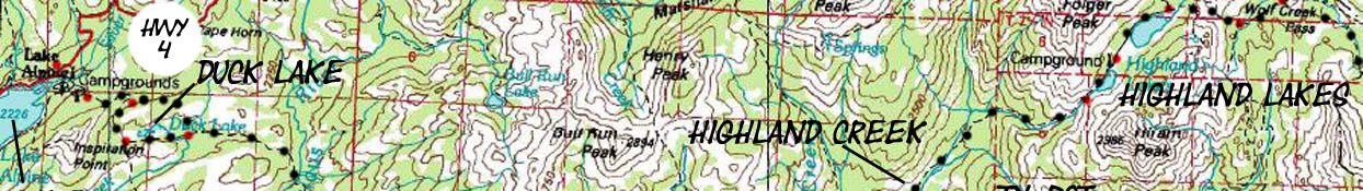
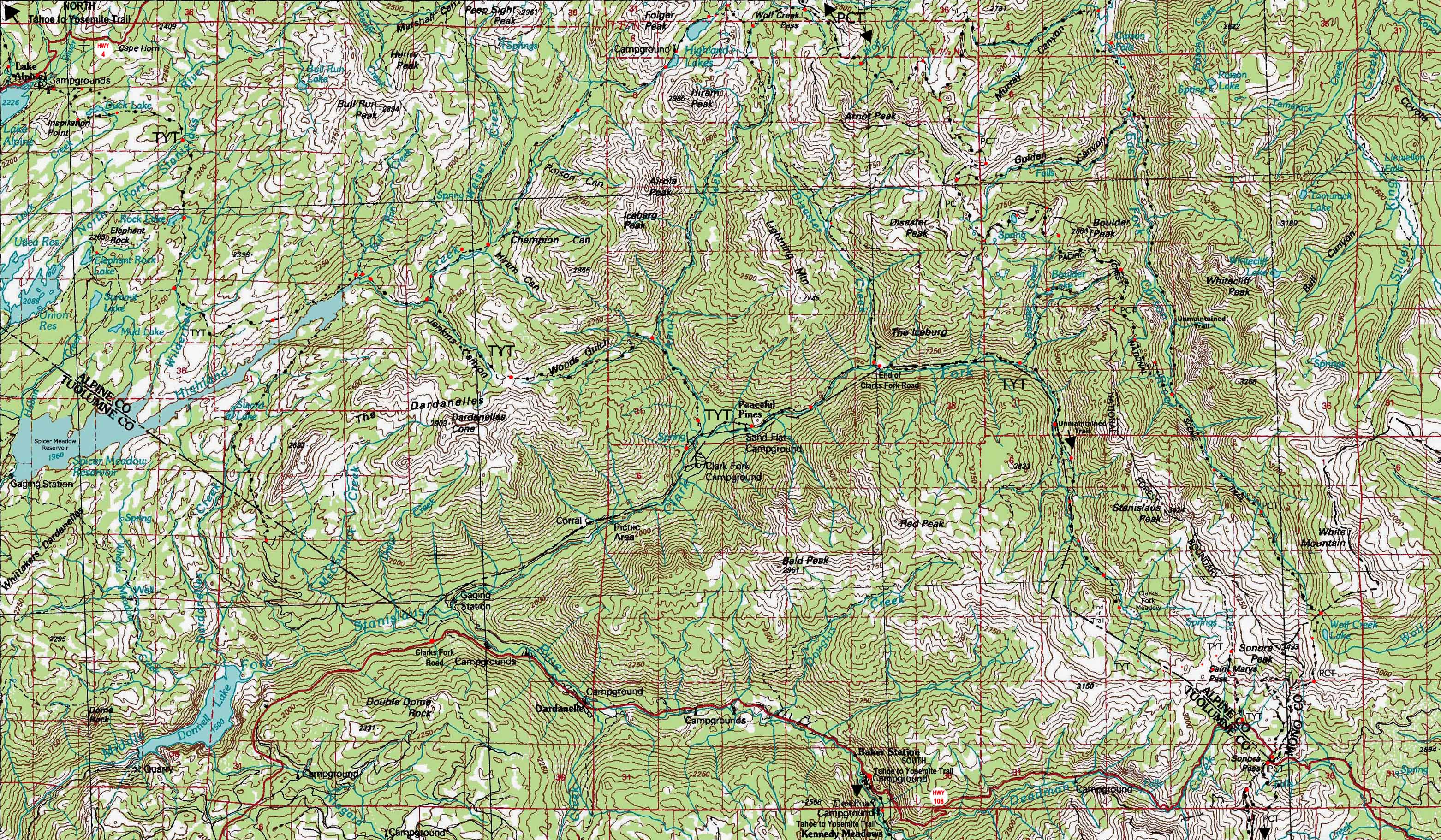
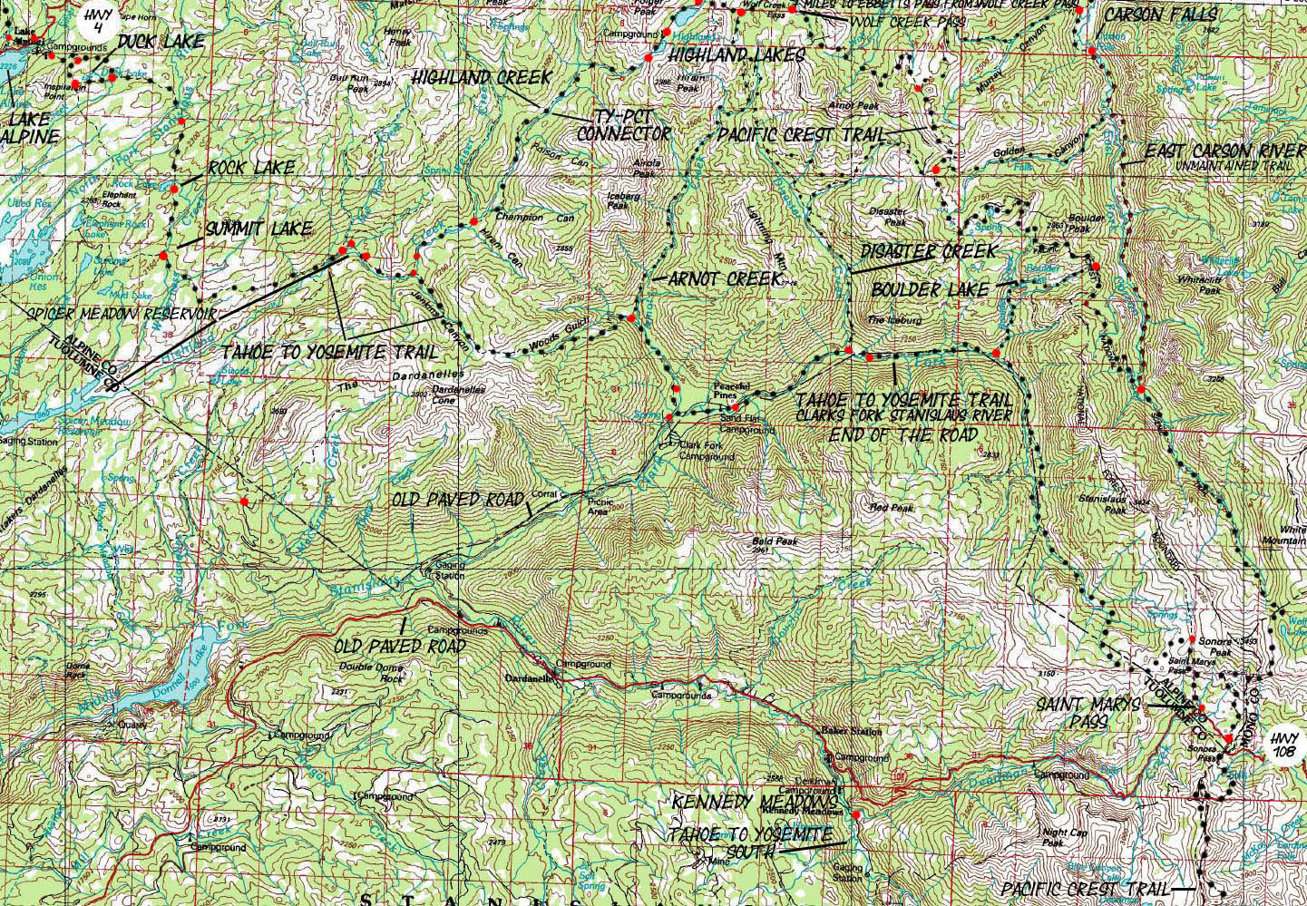
The Main Long and Short Backpacking Route Options across and around the Carson Iceberg Wilderness This topo hiking map depicts the Tahoe to Yosemite Trail as well as the four main trails that connect the TYT to the Pacific Crest Trail through the Carson Iceberg Wilderness. The Carson Iceberg is sandwiched between Highway 4 on its North Side and Highway 108 on the South. This topo hiking map also depicts most of the Pacific Crest Trail across the Carson Iceberg Wilderness, excepting the 7.02 miles from Wolf Creek Pass to Ebbetts Pass. The complete Ebbetts to Sonora Pass Topo map is in the Pacific Crest Trail section of the trail guide covering the PCT between Ebbetts and Sonora Pass. Trail guide pages will eventually be constructed for the Highland and Boulder Lake connector trails between the TYT and the PCT. The red dots along the marked trail routes are links to that specific location in the trail guide. Specific mileage and elevation information, as well as pictures and written descriptions of these key sections of the trail are available on the trail guide pages. The Carson Iceberg Wilderness is set up for Big Loops Though this trail guide is set up for long trips between Tahoe and Whitney, each of the wilderness areas along the way is full of excellent short and medium backpacking opportunities. This is especially true of the Carson Iceberg Wilderness. Besides the Highland Creek Trail on the North side of the Carson Iceberg Wilderness and the Boulder Lake Trail on the South side, this topo hiking map shows how the Arnot and Disaster Creek Trails that lay between these two trails also connects the Tahoe to Yosemite and Pacific Crest Trails. Thus we have four potential backpacking loops of up to 80 miles in length that we can us craft loops of various distance through the Carson Iceberg Wilderness by weaving together sections of the TYT and the PCT using these connector trails. Or, we can hike the PCT and the TYT between Highway 4 and Highway 108 as "trail sections" of 29.44 and 34.64 miles, respectively. Check out this report on this quick 50 mile loop around the Carson Iceberg using sections of both the TYT and PCT. Also note the access that the old paved road that follows the Clarks Fork of the Stanislaus River off of Highway 108 offers to the Southern Arnot and Disaster Creek Trailheads. The old paved road splits off of Highway 108 a few miles West of where Kennedy Meadows is located. Both the Arnot and Disaster Creek trails offer access North up to the PCT, which you can then hike South down to the Boulder Lake connector trail which will bring you back to the Clarks Fork of the Stanislaus where you started. The Northern access to the Arnot and Disaster Creek Trails is through the PGE dirt access road off of Highway 4 to Highland Lakes a few miles West of Ebbetts Pass. Or you can hike South from Ebbetts Pass and access the Southwestern Carson Iceberg by turning Southwest at the Wolf Creek Pass trail junction. The East Side of the Carson Iceberg Wilderness Checking the Northeast side of the map above depicts the East Fork of the Carson River from Carson Falls running South to its junction with the Pacific Crest Trail. This trail is marked by black dots with red centers on the topo map, signifying an unmaintained trail. Trailhead access to this area from the East comes from outside of the Sierra Nevada, from Highway 395. Though the Western Flank of the Sierra Nevada extends and descends for sixty miles from the Sierra Crest to the Valley, the Eastern Flank of the Sierra Crest drops precipitously down to a 5000 foot high desert valley. A series of long valleys bound the Eastern limit of the Sierra Nevada North and South along the whole length of the Eastern High Sierra. Highway 395 runs North and South through these valleys in the shadow of the Eastern Escarpment of the Sierra Nevada from Reno to South of Lone Pine. This is worth driving just to see the Eastern Escarpment of the Sierra. When you hike Westward into the Sierra Nevada from Highway 395 you are actually entering the Sierra less than 30 miles from the Sierra Crest. On the West side you enter the Sierra Foothills sixty miles from the Sierra Crest. The last time I walked into the Eastern Sierra from Walker was 2010. I don't plan on walking up from Highway 395 up to the 8000 foot trailhead at Corral Valley on Rodriguez Flat, but it happens... Our Eastern access point to the upper reaches of the East Carson River to reach the PCT is through the Corral Valley Trailhead, located at 8000 feet of elevation at the end of a 6 mile long dirt road off of Highway 395 just North of the town of Walker. Check out this Google Road Map of the Mill Canyon Road junction with Highway 395. The google map is part of an article exploring the Walker to Sonora Pass backpacking route. Eastern access to the Carson Falls and the loop routes around the Pacific Crest Trail via the remote beauty of the East Carson River are tough hikes with lots of hard miles and climbs. I've hiked South to Tuolumne and North to Tahoe out of here a few times, and this trailhead is on my annual "circuit" of hikes. Though tough, this is a spectacularly beautiful and exceedingly remote part of the Sierra Nevada. Eastern Carson Iceberg Route Options Below the Carson Falls (North of the Falls) we see the trail East through Murray Canyon connecting the PCT with the East Carson River. Above the Falls (South of the Falls) we see the PCT and East Carson River connect through Golden Canyon. Both of these trail are difficult climbs ascending the steep wall making up the West side of the East Carson River's canyon. Continuing South past both of these trail junctions to follow the East Carson River upriver to its unmarked junction with the Pacific Crest Trail is the most difficult route of all. The route up the East Carson River from the Carson Falls to the PCT is an unmaintained route through difficult terrain. This section is physically challenging, will challenge your route-finding skills, and is across a very isolated and lightly traveled route. Arriving at the trail junction of the East Carson River route and the Pacific Crest Trail puts you 7.97 and 9.83 miles South of the Golden and Murray Canyon trail junctions, respectively, and 8.74 miles North of Sonora Pass. You could turn North to loop back to your Corral Valley Trailhead through either Golden or Murray Canyons, or continue South to Sonora Pass on Highway 108, and hitch-hike back to your Corral Valley Trailhead. The Carson Iceberg: Difficulty of Access The difficulty of these Eastern Carson Iceberg trailheads is partially the difficulty of access. Heck, all of the trailheads along the Sierra Crest on Highway 4 and Highway 108 are at the end of long and twisting Sierra roads. Take your travel time to the trailhead into consideration when planning your trips. Free Car Camping Both Highway 4 and 108 have many nice high-altitude free car camping spots in the National Forest Lands along or right off of the highway. Sonora Pass has many well established sites both East and West of the Crestline, while most of the car camping sites on Highway 4 are located East of Ebbetts Pass. Take your time driving up, then set up a nice car campsite and enjoy your first evening acclimating to elevation in leisure. |
High Sierra Road Maps
HIGHWAY 4 CORRIDOR ROAD MAP Ebbetts Pass (PCT) and Lake Alpine (TYT) This is a road map for highway access to the trailheads on the North end of the trail map above. Centered On
|
HIGHWAY 108 CORRIDOR ROAD MAP Sonora Pass (PCT) and Clarks Fork Road and Saint Marys Pass (TYT) This is a road map for highway access to the trailheads on the South end of the trail map above. Centered On
|
Tahoe to Yosemite Trail |
||
Mileages Meeks Bay to Saint Marys Pass Lake Tahoe Meeks Bay to Echo Summit Echo Summit to Carson Pass Carson Gap to Lake Alpine Subtotal Lake Alpine to Saint Marys Pass Total
Back to The
Trail Guide Pages
|
USGS Topo Map Map Name
Compass Offset scale Contours Download this
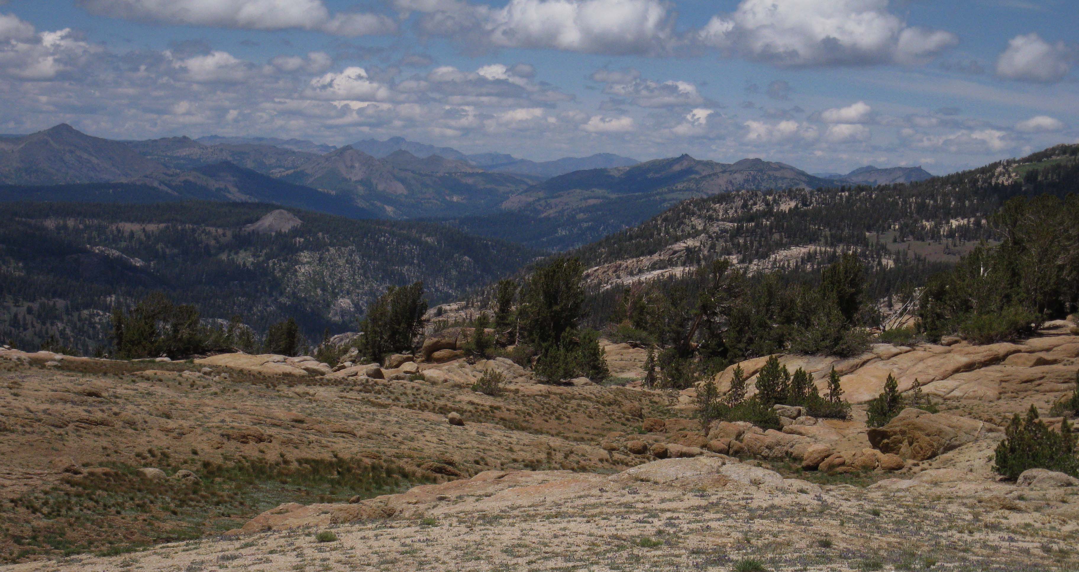
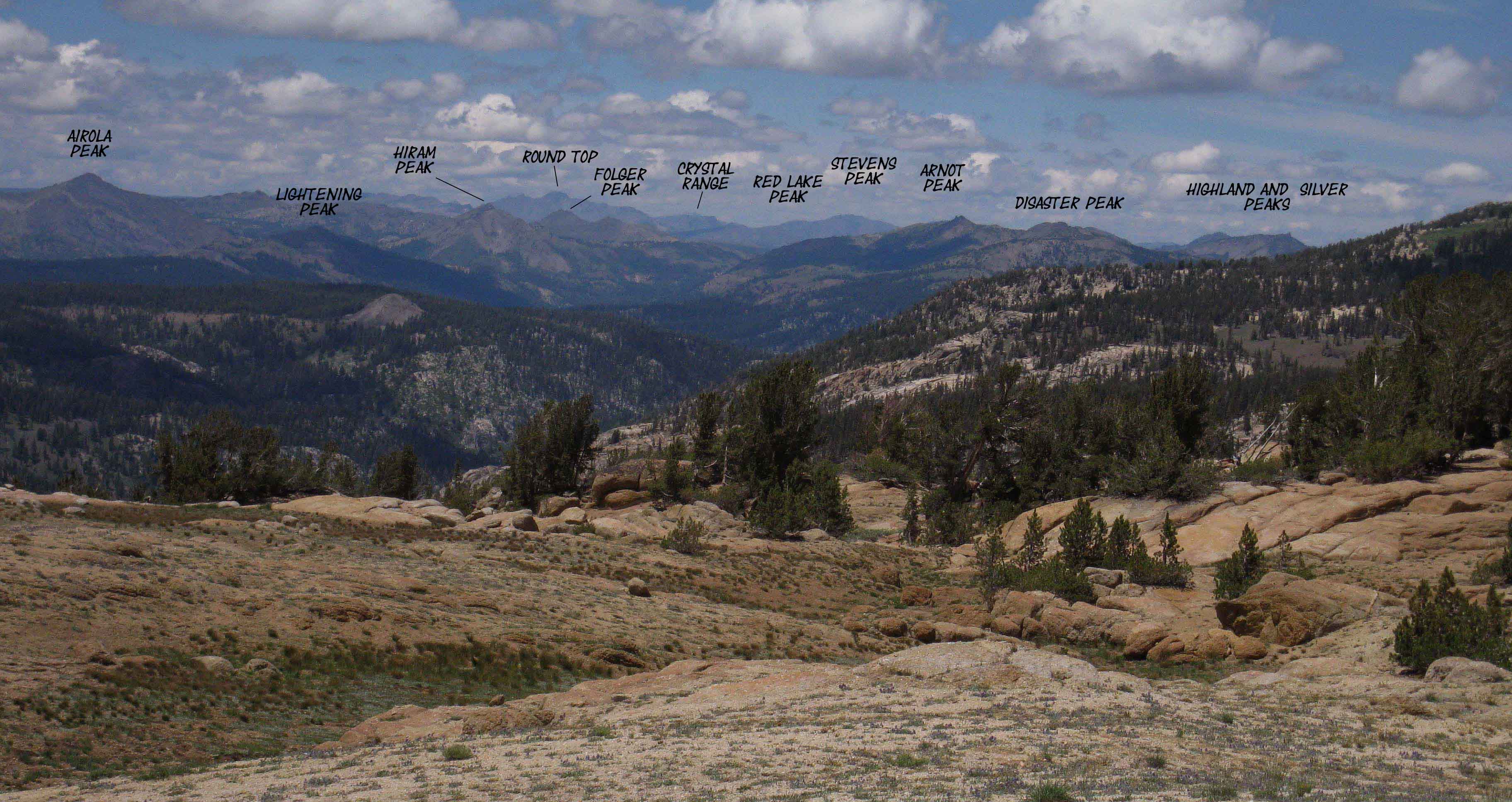
My Favorite Additional Map This map is downloadable, and opens The link above is to a pdf map, opening in a new tab... Those Mountains... We've an amazing set of peaks in the Carson Iceberg Wilderness running off the West Flank of the Sierra Crest depicted on the maps above. Let's take a look at them to our North from Saint Marys Pass just before we descend to end our hike across the Carson Iceberg Wilderness. Trail Guide, |
Carson-Iceberg Wilderness East Flank National Forest Carson Ranger District (775) 882-2766 Bridgeport Ranger District (760) 932-7070
West Flank National Forest Highway 4 Corridor (209) 795-1381 Highway 108 Corridor Backpacking permits for the Northwest flank of the Carson-Iceberg Wilderness, near Lake Alpine along the Highway 108 Corridor is the Summit Ranger District #1 Pinecrest Lake Road Pinecrest, CA 95364 (209) 965-3434 |
| next REGIONAL TOPO MAP PCT North PCT Ebbetts to Carson Pass MAP |
next REGIONAL TOPO MAP TYT North TYT Carson Gap to Lake Alpine MAP |
next REGIONAL TOPO MAP PCT South PCT Sonora Pass to Bensen Lake MAP |
next REGIONAL TOPO MAP TYT South Sonora Pass Region Backpacking Map |
| Elevations | More Information | ||
Lake Alpine: 7330 feet Jenkins Canyon Junction : 6880 feet High point above Saint Marys Pass: 10,400 feet |
TYT and PCT Trail Guide Index Google Road Maps: Highway 4 & Highway 108 |
||
Map Credit |
U.S. Geological Survey, Department of the Interior: The USGS Move the Map to the Sierras. Select size of Maps you wish to locate. Click "Mark Point" on map to see the USGS map grid of the selected map scale. USGS Topographic |