High Sierra
Backpacking
Trail Guide
Forums
Sierra
Weather
Northern
Sierra Weather
Gear
Ebbetts Pass
and
Lake Alpine
Highway 4 Corridor
Weather Forecasts, Reports, Road Conditions and Information
| Mokelumne Wilderness to our North |
Carson Iceberg Wilderness to our South |
High Sierra Nevada Mountain Backpacking & Hiker's Weather Resources
Languages
Trail Skills
Mountain
Safety
Food
Planning
Trail Arts
More
Information
Social
| All Sierra Weather |
Northern Sierra Weather |
Central Sierra Weather |
Southern Sierra Weather |
North |
South |
Mokelumne Wilderness Map |
Carson Iceberg Wilderness Map |
Ebbetts Pass & Lake Alpine
Weather Resources
|
Location Range Besides the weather information we will find links to the maps, miles, resupply, permit, and elevations information for the PCT and TYT here, and to our North and South. Let's get out and go backpacking. |
|
Arrrg...Pages under Construction... Ouick References
All High Sierra Reporting Stations
|
||||||||
Ebbetts Pass Map Lake Alpine Map |
||||||||
| Ebbetts Pass & Lake Alpine Weather Page Index |
||||||||
| Forecasts & Road Conditions |
Real-Time Stations & Snow Sensors |
Radar & Satellite |
Trail Guide Information |
|||||
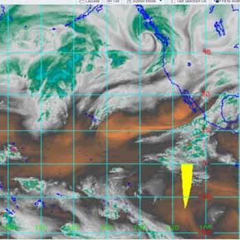
| 7 Day Rain Forecasts & Current Satellite View |
Forecasts, Road Conditions,
|
||||
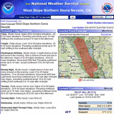
West Slope Sierra Nevada Region Forecast |
Road ConditionsCalTrans
Cal Trans Road Conditions Search
Cal Trans Road Conditions Phone Line 1-800.427.7623 |
Eyes on Lake AlpineWeb Cams
California Webcams
|
||
|
||||
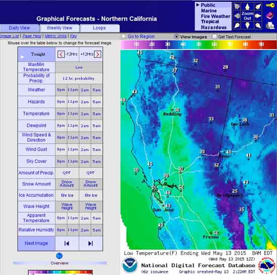
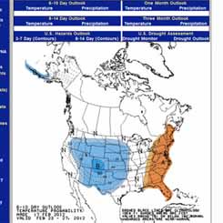
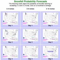
Use this tool to investigate all aspects of the 7 Day High Sierra Forecasts. |
||||
|
||||
Sierra Nevada Mountain Backpacker |
|
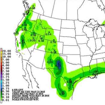
Current to 7 Day High Sierra Precipitation Forecast |
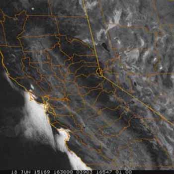
Current Sierra Nevada Satellite Imagery |
| All Precip Predictions & Models | All Satellites |
Northern Sierra Nevada |
|
Northern
|
North
|
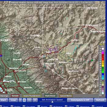
| National Radar Map | All Satellites |
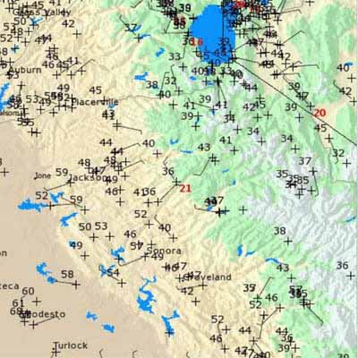
Reporting Stations
|
|||
All High Sierra Reporting Stations
Linked Ground Reporting Station MAPS
Ebbetts Pass Area Station List
The first link below bring you to an expansive map of MesoWest Northern California Real-Time reporting stations.
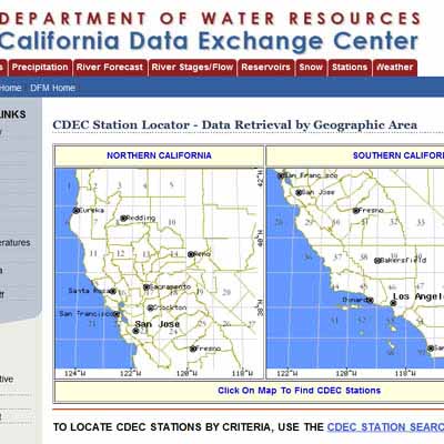
State of California
Sierra Nevada Ground Reporting Stations
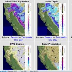
Snotel
All Federal
Snotel Stations
in
California
Federal Reporting Station Locations
West of Ebbetts Pass
Bear Valley
(3 miles West of Lake Alpine)
East of Ebbetts Pass
Winter Joy
National Snow and Ice Data Center
Weather Map
Locate Stations near Ebbetts Pass on this
30 min Topo
All Precip Predictions & Models
Hiking Maps
North Map
Mokelumne Wilderness Backpacking Map
South Map
Carson Iceberg Wilderness Backpacking Map
Click the Red and Black dots on the maps above for Trail Guide and Detailed Map information for the clicked positions, respectively.
Calfornia State Stations
Focus: Mokelumne River to Spicer Meadow along the TYT. Blue Lakes to Wolf Creek on the PCT.
Note: If the California State pages are hanging up refer to the federal MesoWest and Snotel resources. California has problems.
All Ebbetts Pass reporting stations laid out on a hiking map. NAD 27.
#1> Ebbetts Pass (Active state of ca sensor)
Location: High point on Highway 4. Topo Map.
Site Information and Reports from Ebbetts Pass
Daily Report from Ebbetts Pass
Latitude: 38.561000°N
Longitude: 119.808000°W
Elevation: 8700 feet.
#2> Wet Meadows Lake (inactive state of ca sensor)
Location: Between Blue Lakes and Ebbetts Pass. See Topo Map.
Site Information and Reports from
Monthly Report from Wet Meadows Lake
Latitude: 38.610000°N
Longitude: 119.862000°W
Elevation: 8100 feet
#3> Pacific Valley (South of Pacific Grade Summit)
Location: Between Ebbetts Pass and Lake Alpine along Highway 4 on the West flank of the Sierra Crest.
Topo Map.
Site Information and Reports from Pacific Valley
Monthly Report from Pacific Valley
Latitude: 38.6824°N
Longitude: -119.9597°W
Elevation: 8017' ft
#4> Stanislaus Meadow (state of ca sensor)
Location: West of Pacific Grade Summit on Highway 4 along North Fork Stanislaus River.
Topo Map.
Site Information and Reports from Stanilaus Meadow
Daily Report from Stanislaus Meadow
Latitude: 38.505500°N
Longitude: 119.937300°W
Elevation: 7750' ft
#5> Lake Alpine (inactive state of Ca sensor)
Location: Highway Four, 15 miles West of Ebbetts Pass.
Topo Map.
Site Information and Reports from Lake Alpine
Monthly Report from Lake Alpine
Latitude: 38.6780°N
Longitude: -120.1180°W
Elevation: 7100' ft
Real Time Ground Reporting Stations Planning our gear selection for our hike South from Lake Tahoe we have referred to a reasonable selection of real-time ground reporting stations that inform about temp, wind, rain, snow, and humidity. This real-time data gives us both current and historical knowledge of the range of temperatures we can expect to experience at various points down the trail.
This information establishes our gear selection range.
Northern Sierra Nevada |
|
Northern Sierra Nevada Radar Imagery
|
North Pacific and Sierra Nevada Satellite Imagery
|
| National Radar Map | |
Fall-Winter-Spring |
||
snow cover |
snow probability |
weather & temp predictions |
 |
|
 |
| Fall, Winter, and Spring. | Fall, Winter, and Spring. | Good for Summer hot & cold trends. |
Trail Guide Information |
||
| comments | ||
This Weather Page, like the trail guide it is a part of, covers the High Sierra Trails across Highway 4 along the West the Sierra Crestline through Ebbetts Pass and along the Western Flank through Lake Alpine.Therefore the trail guide split into two branches upon departing the Lake Tahoe Basin, and continues South along both the Tahoe to Yosemit and Pacific Crest Trails across Highway 4. The Pacific Crest Trail hikes through Ebbetts Pass along the Eastern fringe of the Sierra Nevada Crestline South to Sonora Pass. The Tahoe to Yosemite Trail emerges from its trek through the deep Summit City Canyon and the even deeper canyon of the North Fork of the Mokelumne by hiking over the top of Mount Reba and down to Lake Alpine. Permits The National Forest Boundary runs North and South along the Sierra Crest across Ebbetts Pass. South of Ebbetts Pass we continue hiking in the Toiyabe National Forest, but now we have transitioned from the Toiyabe administered Mokelumne Wilderness into the Carson Iceberg.From Lake Alpine we also hike North or South into the Mokelumne or Carson Iceberg Wilderness, respectively, but the Western sections of these Wilderness areas are administered by the Stanislaus National Forest. National Forests West Slope: Stanislaus National Forest. East Slope: Toiyabe National Forest. Wilderness South of Highway 4 West Flank of Carson Iceberg Wilderness along the Tahoe to Yosemite Trail, Stanislaus National Forest. East Flank of Carson Iceberg Wilderness along the Pacific Crest Trail, Toiyabe National Forest. Wilderness North of Highway 4 West flank of Mokelumne Wilderness in the Stanislaus National Forest. East flank of Mokelumne Wilderness in the Toiyabe National Forest. Ebbetts Pass Region Hiking Map Lake Alpine Region Hiking Map Ebbetts Pass Region Weather Map |
||
Backpacking MapsPacific Crest Trail Index Tahoe to Yosemite Index Miles & Elevations |
Trail Guide Pages
|
|
| Ebbetts Pass reporting stations laid out on a hiking map. | ||
North: Carson Pass Weather Ebbetts Pass Trail Map South: Sonora Pass Weather Information
| Be Ready for the Range: Basic Facts | Basic High Sierra Weather Resources for the Backpacker |
The Sierra Crest is noted for having the capacity to produce four seasons of weather during a single Summer Day. Rain, snow, hail, fog, lightening, and a bit of sunshine can all happen in quick sequence. The High Sierras are noted for rapid changes in weather and temperature, and the sudden appearance of harsh weather trends. You may experience anything from intense heat to bitterly cold Summer snow storms. Or you may not. In any case, weather must be considered and proper gear preparations made to deal with the range of weather BEFORE entering the High Sierras. Long Distance Backpackers who were on the High Sierra Crest in early August of 2009 experienced just such a series of Summer Snow Storms. Temperatures dropped to the high teens and low twenties, snow and hail fell which partially obscured the trails, and all of those who entertained the misconception that the Sierras only have fine weather during the Summertime were bitterly disappointed. Luckily for the many backcountry travelers who were not properly prepared, those storms blew apart, rather than consolidated and deepened. Weather considerations should guide your gear selection. |
Weather Preparations
|
Backpacker ForumsHave a great Sierra Nevada route or trip to relate?Post it on Anyone can post up comments and questions in existing topics posted on the High Sierra Backpacking Trails Forums or in the High Sierra Backpacking Topics Forums. If you have comments about weather conditions at Ebbetts Pass and the Highway 4 Corridor, this is the place to post up:Ebbetts Pass Weather Forum |
North: Carson Pass Weather Ebbetts Pass Trail Map South: Sonora Pass Weather Information
Trailhead
Contact
Alex Wierbinski

Backpacking Lake Tahoe to Mount Whitney
Your guide to the High Sierra Crest, including the Tahoe to Yosemite, Pacific Crest, and John Muir Trails
