Round Top Lake gion15 Lost Keys Lake
Killer Sunset at The Sisters near Carson Pass Lake Tahoe to Mount Whitney: Crown Jewel of the Pacific Crest Trail Need a Map? Lost Al near Lost Keys Lake
Banner: Tahoe to Whitney Maps, Tahoe to Yosemite Trail
Dicks Lake   Lake Aloha
Dicks, and Fontanillis Lakes from Dicks Pass

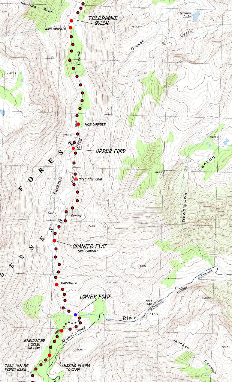
BACKPACKING MAP: Summit City Creek from Telephone Gulch to the Rock Bowl

Hiking The Tahoe to Yosemite Trail South of Round Top out of Summit City Creek

7.5 minute USGS Custom Backpacking Map of the Mokelumne Wilderness in the El Dorado National Forest

Aloha Lake under Pyramid Peak from Dicks Pass
                     
Tahoe to Yosemite Maps and Mileages Other Information Tahoe to Whitney Indexes More Miles and Elevations Info Weather, Map Data
North

Upper Summit City Creek

South

Rock Bowl to Bee Gulch

Region Map

Echo Summit to Lake Alpine

Miles
and
Elevations

Carson Gap to Lake Alpine
All Summit City Creek

Section Topo Maps Carson Gap to Highway 4

Further North Carson Pass Region All Miles Tahoe to Whitney   All Maps Tahoe to Whitney Echo Summit to Carson Gap   Lake Alpine to Saint Marys Pass 1x2 Section Map Carson Gap to Lake Alpine Trail Guide Telephone Gulch to Upper Ford

Carson Pass Weather Information Map

Weather Page

map, miles, elevations, and permit info
           

6.29 miles South on unmaintained trail between Telephone Gulch across Summit City Creek's two fords, through dense forest, to Camp Irene

North: Upper Summit City Creek          Miles and Elevations            Further North: Carson Pass Region          Click Red Dots      All Summit City Creek          South: Lower Ford to Bee Gulch

Telephone Gulch on Summit City Creek through Upper and Lower Fords

North: Upper Summit City Creek                            Further North: Carson Pass Region                            South: Lower Ford to Bee Gulch

Location: The Mokelumne Wilderness on the Tahoe to Yosemite Trail

Main Features: This topo hiking map as well as the previous and next detailed topo hiking maps are important because they depict the section of the Summit City Creek that is unmaintained. The unmaintained section begins at the trail junction below Fourth of July Lake and extends South to Camp Irene. This section is arguably the hardest part of the Classic Tahoe to Yosemite Trail.

Once you intersect with the Summit City Creek Trail and turn South, down river on Summit City Creek, you will be backpacking across unmaintained "trail," if you are sharp enough to stay on the old trail route, until you reach Camp Irene on the Mokelumne River. Between the junction with Summit City Creek down to Telephone Gulch, the well-trodden trail bed is discernable and easy to follow despite being crossed by many fallen trees and some sections of dense over-growth.

From Horse Canyon South the trail bed deterorates considerably, and South of Telephone Gulch to the open rock area before the first ford of Summit City Creek, the going is pretty rough. There are dense forests of Sword Ferns that have large networks of exposed, elevated roots. The roots want to trip you, so the Swords can impale you. There are wide sections of downed forest and washouts.

These areas are hard to travel across due to the occassional necessity to climb over downed trees and push through dense overgrowth.  Footing is very poor. After all that you come to an exposed section of fine granite before reaching the first ford of Summit City Creek.

This beautiful section of exposed rock is well ducked, and leads to the first ford. A nice campsite sits under the edge of the stand of trees just North of the Upper Ford. After fording, turn right to follow the route over a rocky granite outcropping. We are passing around a rough section of Summit City Creek as it passes though a deep and narrow gorge.

Summit City emerges from its tumultous path flowing onto a wide granite flat as our path again accesses the creek. There's a nice campsite on the far South side of the flat. At the end of the flat the route again climbs away from Summit City Creek as it begins its steep drop down a granite encased cut in the mountains. We will make our way down a hot exposed mountain side filled with a dense maze of Manzanita.

At the bottom of our descent we again see Summit City Creek emerging into a densely wooded flat where we again converge with the creek. A short hike through creek-side debris brings us to the lower ford.

refer to the trail guide for more...


Mapping, Mileage, and National Forest Permitting Information


Miles and Elevations

miles and elevations


More Information

Trail Guide: El Dorado National Forest information

Trail Guide: Stanislaus National Forest information

Physical location: Between Highway 88 at the Carson Pass to Highway 4 at Lake Alpine


US Forest Service websites

National Forest Backpacking permitting authorities

El Dorado National Forest

Stanislaus National Forest

Wilderness Area: Mokelumne in the El Dorado

TW information : Mokelumne Wilderness

Fed information: Mokelumne Wilderness

Wilderness Area: Mokelumne in the Stanislaus

Molkelumne Wilderness

Map Information

Map Name: Mokelumne Calif.-Nev., 1979, 7.5 minute Topographic


Compass Offset: Magnetic North is 16 and 1/2 degrees East of True North


scale: 1:24 000

Contours: 40 feet

The Tahoe to Yosemite Trail between Carson Pass and Lake Alpine

Backpacking permitting authority: The El Dorado National Forest on the North Side of the Mokelumne Wilderness on Tahoe to Yosemite Trail at the Carson Pass on Highway 88. The Stanislaus National Forest administers the South side of the Mokelumne Wilderness, if you are enterning the Wilderness from the Lake Alpine area on Highway 4.

National Forest: You are in the El Dorado NF from Carson Pass, until you reach the ford of the Mokelumne River at Camp Irene. Here you depart the El Dorado NF and enter the Stanislaus NF. The Mokelumne Wilderness continues within the Stanislaus NF up to the top of Mount Reba. At the top of Mount Reba you exit the Mokelumne Wilderness.

Guide Pages

Back to Tahoe to Alpine Trail Guide Index

North to Round Top Lake

South to Lake Alpine


North: Carson Pass Region                                                     South: Rock Bowl to Bee Gulch

Elevations   More Information

Telephone Gulch: 6720 feet

Upper Ford: 6560 feet

Lower Ford: 5540 feet

elevation drop: 1180 feet

miles and elevations

Guide Index North: TYT Carson Gap to Lake Alpine

Guide Index South: Highway 4 to 108

Map Section: Echo Summit to Lake Alpine on a map: Click Red Dots for trail guide pages.

Trail Guide, Page: Summit City Creek

Google Map: No Road Access.


Map Credit: Thanks, USGS !

U.S. Geological Survey, Department of the Interior

The USGS

Download Free USGS Topo Maps

USGS MAP LOCATOR

I love these guys...

Move the Map to the Sierras. Select size of Maps you wish to locate. Click "Mark Point" on map to see the USGS map grid of the selected map scale.

USGS Topographic Maps

Map Information

Map Symbols

Trailhead
Comments: Carson Gap to Lake Alpine
Contact: Alex Wierbinski

top of page

Lake Tahoe to Mount Whitney

Your guide to backpacking the Sierra Crest, including the Tahoe to Yosemite, Pacific Crest, and John Muir Trails

top of page

© Lake Tahoe to Mount Whitney: Crown Jewel of the Pacific Crest Trail