


Topo Hiking Map
Lake Alpine
on
Highway 4
Backpacking
Map of the Tahoe to Yosemite Trail between the Mokelumne Wilderness and Carson-Iceberg Wilderness
Custom 7.5 minute USGS Backpacking Topo Map linked to trail guide information

| Tahoe to Yosemite Maps and Mileages |
BIG Maps Information & Guide Pages |
Tahoe to Whitney Indexes |
More Miles and Elevations |
Roads | Weather Map Data |
|||||||||||||||||||
Topo Hiking Map |
North |
South |
North |
South |
Big Topo Map North Mokelumne Wilderness |
Big |
Trail |
Trail Guide Section Index Highway 4 to Highway 108 |
Resupply The Lake Alpine Lodge |
All Maps Highway 4 to Highway 108 |
All Miles Tahoe to Whitney |
All Maps Tahoe to Whitney |
North Carson Gap to Lake Alpine |
Lake Alpine to Saint Marys Pass |
South Sonora Pass to Tuolumne Meadows |
map, miles, elevation, and permit info |
||||||||
| Maps and Miles | Regional Information | Indexes | Miles and Elevations | |||||||||||||||||||||
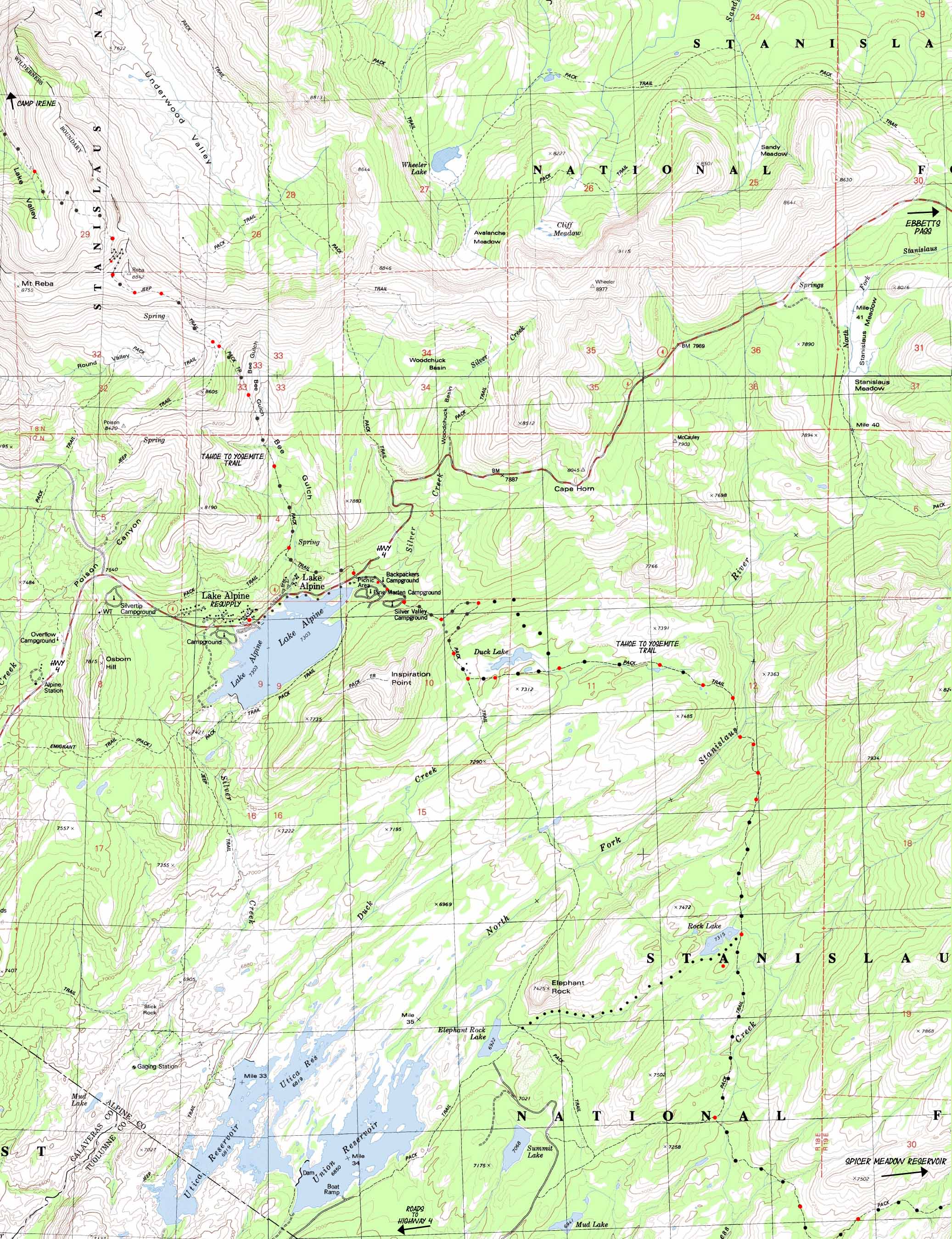
Lake Alpine Topo Backpacking Map
2.78 miles from Top of Mount Reba to Bee Gulch Trailhead on Highway 44.74 miles from Silver Valley Trailhead to Rock Lake
| North TYT Summit City Creek to Bee Gulch |
Click RED DOTS | Highway 4 Roadmap | Click Trail Labels with ARROWS |
South TYT Lake Alpine to Spicer Reservoir |
|
| North TYT Summit City Creek to Bee Gulch |
Click RED DOTS | Highway 4 Roadmap | Click Trail Labels with ARROWS |
South TYT Lake Alpine to Spicer Reservoir |
Mapology |
||||
MAP NOTE What's important for our general reference purpose is that each side of a square is 1000 meters, or a Kilometer. From my point of view that is 1093.6 yards or .62 of a mile. Diagonal: 1414.22 meters, if my trig is correct. That converts the diagonal distance into 4,639.8 feet or .88 of a mile.
|
Let's Talk; |
Trail Notes Why is this an issue? Because I want a safe, comfortable, and quiet campsite for a couple of nights while I resupply, rest, and recharge at/near Lake Alpine Lodge. The Lake Alpine Lodge is our first resupply point South of Lake Tahoe, and we am going to get full value out of the experience. This will be our first day off since departing Meek Bay Trailhead. Taking a full day off requires spending two nights here. The first night will be following that day's hike into Lake Alpine. The following day will only involve a couple of walks from my campsite to the Lake Alpine Lodge and back. We will pick up the food bucket for the next section of trail we sent to ourselves via Lake Alpine. We will eat a couple of really good breakfasts. The last time I was at Lake Alpine (Sept. 27 2013) I hooked up with a couple of hunters who were hanging out at the Lake Alpine Lodge. These guys had set up a luxury campsite in the car campground across from Lake Alpine Lodge. The campground was closed for Winter, but the Stanislaus National Forest leaves the gate open so the hunters can use it. There were hunters everywhere. These guys were from Oakdale (Oakdale has sadly grown too big for its own britches...) and brought up a big BBQ, stoves, and bunches of car/hunters camp gear, and set up a very comfortable command center for their efforts. I ate and drank well with these good dudes. It was a pleasure to camp with a couple of the local lifetime Sierra Nevada hunters and Valley residents. They are good dudes, lots of the hunters and fishermen up here. The Long and Short of it... Many Backpacking Trip Options This is the only place we can begin trips across the Carson Iceberg to Saint Marys Pass along the actual route of the TYT, but it's also a great starting point for grand loops around the whole Carson Iceberg Wilderness, medium distance trips up one canyon and back on another, or just a short loop around Duck or Rock Lake and back to Lake Alpine. There is lots of fine territory to explore, and running across it on the Tahoe to Yosemite Trail is the first step to getting to know more of the local terrain, and offers us a good vantage point to plan local trips that reveal more of the terrain. Vital Tahoe to Yosemite Trail Resupply Spot Thinking Ahead Pack the food carefully to get it just right. Each section of trail between resupply point gets higher, longer and harder as we hike South. This next section of trail South from Lake Alpine does not fall short, and if you follow my advice you will extend this section of your hike through the Carson Iceberg even more. We have lots of trail options South from Lake Alpine on the TYT. I sometimes add about 15 miles and 3 or 4 thousand feet of elevation by turning NE off of the TYT to join up with the PCT at Wolf Creek Pass via Highland Creek. From Wolf Creek Pass the Southbound Pacific Crest Trail tracks down to the East Carson River, a place that I have really enjoyed over the years. I consider the upper section along the East Carson River one of the best routes North or South through the Carson Iceberg Wilderness if you are both hiking the long trails and want to see the best of both trails. But that means missing the unmaintained section of trail from Eureka Valley up to Clarks Meadow on the Southern end of the Tahoe to Yosemite Trail. Hikers South from Clarks Meadow cannot even expect to find an unmaintained trail. South of Clarks Meadow the best we will find are a sprinking of "wild ducks." Wild ducks are irregular ducks along a route that may or may not mark turns in the route, fording points, and other key decision making points along a route. As Sonora Pass and Saint Marys Pass are located less than a mile from each other where the PCT and TYT intersect with Highway 108 the end result of either hike is almost at the same, but the trail to them go through radically trail conditions and terrain. Hiking the various routes will introduce us to much more territory along the way. The Short of it... For short and medium distance backpackers Lake Alpine is your key trail head for trips North through the Mokelumne Wilderness to Carson Pass. Southbound medium distance backpackers have a wide selection of trip routes to choose from in the Carson Iceberg Wilderness when we pass South through the Silver Trailhead. There are a web of interconnected trails across the Carson Iceberg which generate lots of potential trips. South from Lake Alpine This web of trails follows the web of drainages cutting through the Sierra flank flowing West from the Sierra Crestline, and each leads us Northeast up to the Pacific Crest Trail off of the Tahoe to Yosemite Trail. The Tahoe to Yosemite and Pacific Crest Trails are linked by no less than four trails between Highway 4 and Highway 108. Loops of 30 to 90 miles can be crafted by linking sections of the Tahoe to Yosemite and Pacific Crest Trail staying within the Carson Iceberg Wilderness. The maps and trail guide South of Lake Alpine will describe two of them closely, the Highland and Boulder Creek trails. North from Lake Alpine Heading North from Lake Alpine offers the long hiker one great long distance High Sierra route. The Tahoe to Yosemite Trail route North to Carson Pass is special in a number of ways. Unlike the Tahoe to Yosemite route South of Lake Alpine, hiking North offers many fewer hiking options and loops. But the trail North has other advantages. Remote No, I take that back. I once met a father leading his daughter and her best friend back from a night of camping past the Horse Canyon trail junction. Those kids had never seen anything like it. Dad brought them on a nifty trip! The lonely status of the only through trail to Highway 88, the Northbound Tahoe to Yosemite Trail, is likely because it features an excellent 9 mile section of unmaintained trail North of Camp Irene to the Summit City Creek trail junction below Fourth of July Lake. Although this is a real fun section of the route, being a challenging section for backpackers with good route finding sense, good backcountry skills, and good fitness, the lack of maintained trail through here keeps backpackers guessing, and the backpacker traffic low. Unmaintained Trail I've hiked seven or eight times through Summit City Creek without maps. Interestingly enough, even though I became personally familiar with the terrain, the seasonal changes cut by the forces of the Winter Snows, the Spring runoff and the resulting wild growth, each year I find new things and new obstacles. One year it was great swaths of avalanche-smashed trees (really-one Winter an avalanche brought down a bunch of dead lodgepoles which were an exciting challenge to climb over... after I got over them!), and another year it was "The Green Monster." This section has always brought new circumstances than neither my memory, a map, nor your GPS can account for. The Skills Lab Seasonal Translations The granite gorge along Summit City is beautiful, as are the variety of terrains we encounter approaching and exiting the unmaintained section through Summit City and the North Mokelumne Canyons. Add physical and social isolation to the beauty of the route, and we have the makings of a unique section along a long backpacking trip down the Tahoe to Yosemite Trail, or an excellent short trip between Lake Alpine and Carson Pass. If we drive up to Lake Alpine we can easily hitch back via 89 through Markleyville to Highway 4, and West over the Sierra Crest at Ebbetts Pass back to our ride at Lake Alpine. See, I've got this all figured out for us... The reasons to hike North from Lake Alpine are compelling. The beauty, isolation, hard work, and route-finding are a crucible of experience hard to find in such a unique configuration that brings out and together so many of our internal assets. Lake Alpine is Good for Us As you can see, I don't believe we can lose by hiking in either direction from Lake Alpine. The deal is to make sure we are in sufficient physical condition, and have the required route-finding skills. Back to the Topo Map on this page Main Features of this topo map Following the old jeep trail South leads us through massive fields of Mule Ears, and soon rewards us with a couple of glimpses of crystal blue Lake Alpine sparkling through the trees nestled in at the Southeastern Base of Mount Reba. The jeep trail is fully in use, and in reasonable condition. We jump off the jeep trail where our Tahoe to Yosemite trail continues straight Southwest where the jeep road bends South to head down mountain. The junction is well marked. The Southbound backpacker veers left off the jeep trail to follow Bee Gulch down towards the East shore of Lake Alpine. Cutting off the jeep trail marks our turn into the top of Bee Gulch, which will be our last segment of trail down to the end of this Carson Gap to Lake Alpine section of the TYT. Congratulations! This was a challenging section of trail. Following Bee Gulch brings us through a delightful mountain-side meadow bracketed by volcanic ridges of the same fine statuesque volcanic forms that decorated our route climbing up the North side of Mount Reba. Each spire and jagged ridge beautiful, and each a reflection of its unique combination of environmental factors. Volcanic material flowed over, around, and right up the great granite valleys, when it did not outright flood and fill them. Radical waves of volcanic activity created the unique interface zones the we are enjoying today. Looking across Lake Alpine towards the ancient monument to volcanic power, The Dardanelles, we can see long fingers of granite terrain moving East up the Sierra Crest between our position within volcanic terrain and the distant granite of The Dardanelles. We will be crossing a significant length of granite terrain between Lake Alpine and where we cross the Northeast end of the Dardanells through Jenkins Canyon... I digress... Once over the top of Mount Reba we will be pointing ourselves Southeast into a different type of terrain. Lake Alpine and the terrain to the South beyond is granitic, but not for long. Looking South from the top of Reba we can see the granite terminating in the massive volcanic formations of the Dardanelles, which dominate the horizon in the distant South past Lake Alpine. Nice. That's where we're going! Our first resupply stop and first "days off" are going to be at Lake Alpine, which is set in beautiful granitic terrain. Beside granite and blue water, Lake Alpine supports a resupply bucket service, and offer a wide selection of services including hot food, a bar, a little grocery store, laundry and hot showers. Bear Valley also has a nice little little grocery store and deli, sports shop, and US Post Office. About forty miles West down the mountain on Highway 4 is the little town of Arnold, where full medical services and regional services of every type are avaiable. |
Maps, Miles, Elevation, |
|
Miles and Elevations North South Trail Guide Section Indexes North South
Backpacking Permitting AuthorityNational Forest
|
USGS Topo Map Information Two maps NW: Mokelumne Peak, 1979, 7.5 minute USGS topographic map NE: Pacific Valley, 1979, 7.5 minute USGS topographic map SE: Spicer Meadow Reservoir, Calif, 1979, 7.5 minute USGS topographic map Compass Offset scale Contours South into the Carson-IcebergBackpackers continuing South on the Tahoe Yosemite Trail hike into the Stanislaus National Forest administered area of the Carson-Iceberg Wilderness at the Silver Valley Trailhead. You actually entered the Stanislaus National Forest's section of the Mokelumne Wilderness when you crossed the North Fork of the Mokelumne at Camp Irene... Permits for backpacking trips heading South into the Carson-Iceberg Wilderness or North into the Mokelumne Wilderness from Lake Alpine both require a wilderness permit from the Calaveras Ranger District of the Stanislaus National Forest. Just as an interesting fact: the Sierra Crest itself divides both the Mokelumne and Carson-Iceberg Wilderness between National Forests. The Eastern side of both is administered by the Toyiabe National Forest. The Western Mokelumne is administered by the El Dorado and Stanislaus National forests. The Western slope of the Carson-Iceberg is in the Stanislaus National Forest. Virtually the whole Eastern Slope of the Sierras is within the Toyiabe National Forest. Wilderness Areas in the Stanislaus National ForestAll Stanislaus Contact Information All Wilderness Contact Information Mokelumne WildernessCarson-Iceberg WildernessEmigrant WildernessPhysical location The Mokelumne Wilderness is North of Lake Alpine on Highway 4, the Carson Iceberg South. Emigrant Wilderness is West of the Sierra Crest South to Yosemite bounded on the South side of Highway 108. |
North: Summit City Creek to Bee Gulch Click RED DOTS South: Duck Lake to Spicer Reservoir
| Elevations | More Information | |
Mount Reba Lake Alpine elevation change North TYT South TYT |
Guide Index North Guide Index South Index Map. click for info Trail Guide Page |
|
Map Credit: |
U.S. Geological Survey, Department of the Interior The USGSDownload Free USGS Topo Maps I love these guys... Move the Map to the Sierras. Select size of Maps you wish to locate. Click "Mark Point" on map to see the USGS map grid of the selected map scale. USGS Topographic Maps |