High Sierra
Backpacking
Trail Guide
Forums
Sierra
Weather
Gear
The
El Dorado National Forest
for
Long distance and Local High Sierra
Backpackers
Hiking
Tahoe to Yosemite and Pacific Crest Trails
through
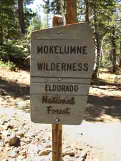
Mokelumne Wilderness
Languages
Trail Skills
Mountain
Safety
Safety
Incidents
Food
Planning
40 Days to Whitney Introduction Tahoe-Yosemite
Trail Arts
More
Information
News
and
Science
Social
| National Forests & Parks Index |
Lake Tahoe Basin Management Unit |
El Dorado National Forest |
Toiyabe National Forest |
Stanislaus National Forest |
Yosemite National Park |
links & maps |
contacts |
| Sequoia-Kings Canyon National Park |
El Dorado National Forest
All
Contact Information
Everything you Need in One Easy Place
Mountain Safety Issues
Inciweb
El Dorado National Forest
| Desolation Wilderness El Dorado NF Permit Information |
Mokelumne Wilderness El Dorado NF Permit Information |
Carson Pass Management Area
El Dorado NF Permit Information
The |
|||||||||||||||||||||||||||||||||||||||||||||||||||||||||||||||||||||||||||||
ALL Contact Information Paper & Online Maps
Mokelumne Wilderness Data
The El Dorado National Forest We pretty much ignore the Western Trailheads into Desolation Wilderness from the El Dorado National Forest because the Tahoe to Yosemite Trail starts out of Meeks Bay, and they are a bit remote from our Tahoe to Yosemite and on down to Whitney goals. Nonetheless, we could easily begin our Tahoe to Whitney backpacking trips through these Western trailheads accessing Desolation Wilderness through the El Dorado National Forest. Though the El Dorado National Forest administers the Western Flank trailheads accessing Desolation Wilderness it does not administer the wilderness itself. Permitting for all access is through recreation.gov's Desolation Wilderness Page, which can be accessed from the LTBMU or El Dorado NF Desolation Wilderness links:
Split Administration of the Mokelumne Wilderness Around the Mokelumne Wilderness Though the Southbound Pacific Crest Trail hiker enters the El Dorado NF via Carson Pass we soon find that the majority of our hike South on the PCT down to Ebbetts Pass along the Sierra Crest is weaving along the Eastern edge of the Mokelumne Wildernes along the Western boundary within the Toiyabe National Forest. The National Forest boundary between the El Dorado and Toiyabe National Forests, and the PCT, follow the Sierra Crestline South. We can use the maps below to examine the differences between the TYT and PCT routes. These maps also reveal that the terrain and routing of the PCT and TYT make tying them together into a big hiking loop impossible. This is unlike the Carson Iceberg and Emigrant Wilderness to our South, where we can use a range of connector trails to create alternative long distance routes or long local loops around each wilderness. Carson Pass region Hiking Map Mokelumne Wilderness Hiking Map Hiking South from Carson Pass on Highway 88 The Season of the Carson Pass Cabin is from when the "snow melts...until the snow starts falling," Call the Carson Pass Cabin or the Amador Ranger Station for the precise status of the Carson Pass Cabin. The Amador Ranger Station issues permits when the Carson Pass Cabin is closed. North from Carson Pass Though Northbound backpackers starting trips out of Carson Pass are entering the Meiss Country of the LTBMU, the fine folks at the Carson Pass Cabin will issue backpacking and fire permits for all trips North and South out of Carson Pass.
More Information
|
|||||||||||||||||||||||||||||||||||||||||||||||||||||||||||||||||||||||||||||
Carson Pass Management Unit |
The Lay of the Land Backpacking South out of the Lake Tahoe Basin and out of the Lake Tahoe Basin Management Unit through the Carson Gap, we are entering the Amador Ranger District of the El Dorado National Forest near the beginnings of the boundary between the Toiyabe and El Dorado National Forests. Both of these National Forests border the Lake Tahoe Basin Management Unit, the Toiyabe around the Eastern side of Lake Tahoe and the El Dorado the Western. These National Forests meet on the Southern edge of the Lake Tahoe Basin, where the Toiyabe NF boundary-line running North-South along the crest line of the Carson Range intersects with boundary of the El Dorado coming around the Southwestern crest line of the Tahoe Basin. These lines intersect and run South down the High Sierra Crest from near our exit point out of the Tahoe Basin through the Carson Gap. Hiking South through the Carson Gap on the TYT-PCT route out of the Lake Tahoe Basin puts the boundary-line between the El Dorado and Toiyabe National Forests just to our left, (East) on our way down to Carson Pass. This boundary continues South along a very convoluted line down the Sierra Crest to Ebbetts Pass, with our Pacific Crest Trail route bouncing between the El Dorado and Toiyabe National Forests, and in-and-out of the tattered boundary of the Mokelumne Wilderness as well. Essentially, the El Dorado National Forest administers the Western flank of the Sierras from Carson Pass South to a boundary described by the North fork of the Mokelumne River. We will enter the Stanislaus National Forest where we cross the river on our way to Lake Alpine along the Tahoe to Yosemite Trail route, while the Toiyabe National Forest administers the Eastern flank of the Sierras from far to the North of Lake Tahoe and far to the South past Ebbetts Pass along the Pacific Crest Trail. PCT Though the trailhead of the Southbound Pacific Crest Trail out of Carson Pass is administered by the Amador Ranger District, the majority of our route South is actually within the Toiyabe National Forest. The Toiyabe National Forest runs along the Eastern Flank of the Sierra Nevada from the East Flank of the Carson Range North of Lake Tahoe all the way down to Yosemite. The Northeast boundary of Yosemite National Park is composed of the Toiyabe's Hoover Wilderness. The majority of the length of the hike down Pacific Crest Trail from Carson Pass to the Yosemite Boundary at Dorothy Lake Pass is across the Toiyabe National Forest. Backpackers starting trips from the East will contact the Carson Ranger District of the Toiyabe for permits. Conclusion The Tahoe to Yosemite Trail explores great sweeps down the Western flank of the Sierra Nevada Mountains before climbing back up to the crestline on its way down to the Yosemite Boundary, while the Pacific Crest Trail sticks high up near the crestline, mostly along the Eastern flank, with a few short exceptions. Both of these trails pass through the Mokelumne Wilderness between Highway 88 and Highway 4, and each explores a different aspect of the Wilderness.. The Mokelumne Wilderness The Mokelumne Wilderness showcases and protects the beautiful terrain along the Sierra Crest and flanks between the Carson Pass along Highway 88 South down to Ebbetts Pass on Highway 4. The Mokelumne Wilderness is divided East and West along the top of the Sierra Crestline from Carson Pass South down to Ebbetts Pass. The Mokelumne Wilderness covers territory on both the Eastern and Western flanks of the Sierra Nevada, but the majority of the Mokelumne Wilderness lays on the Western flank, within the El Dorado National Forest. The Eastern side of the Mokelumne Wilderness has a complex boundary line that is deeply penetrated by cut outs with road access as opposed to the massive undisturbed bulk of the Western Mokelumne Wilderness. The Eastern side of the Mokelumne Wilderness in the Toiyabe National Forest looks like it was drawn with a shotgun. The PCT The Eastern side of the Mokelumne Wilderness is therefore sitting within and is administered by the Toiyabe National Forest. The Mokelumne Wilderness along the Western flank of the Sierra Nevada is within the El Dorado National Forest. The Pacific Crest Trail is the Eastern Flank route along the Sierra Nevada Mountain crestline across the Mokelumne Wilderness, though the Toiyabe National Forest continues far South of where the Mokelumne Wilderness terminates just a bit North of Ebbetts Pass. The Toiyabe National Forest administers the Pacific Crest Trail route South through the Carson Iceberg Wilderness down to Sonora Pass, and most of the route from Sonora Pass South to the Yosemite National Park boundary at Dorothy Lake Pass as well. The majority of your PCT hike between the Lake Tahoe Basin down to the Yosemite boundary is within the Toiyabe National Forest. Not so with the Tahoe to Yosemite Trail's route. The TYT The Tahoe to Yosemite Trail passes South into the Mokelumne Wilderness when it turns onto the Western flank of the Sierra Nevada South of the Carson Gap. South of Carson Pass the Tahoe to Yosemite Trail passes through the heart of the El Dorado National Forest's section of the Mokelumne Wilderness, after passing through the heart of the pretty little Carson Pass Management Area. In total, the El Dorado National Forest only spans 13.05 miles of our trip, but they are beautiful and exciting miles, from the Carson Gap to the ford of the North Mokelumne River at Camp Irene. Unlike the Pacific Crest Trail's high and dry route deeply cut through the desolate volcanic beauty of the Eastern Flank of the Sierra Crestline, the Tahoe to Yosemite Trail begins shedding elevation after crossing South of Round Top. We will hike down into the unmaintained trail section through Summit City Creek's great granite canyon to the North Mokelumne River at Camp Irene, where we again pick up regular trail as we pass out of the El Dorado National Forest. Though the TYT and PCT routes shared the same trail from Middle Velma Lake in Desolation Wilderness down to the Carson Gap, from our turn Southwest into the Summit City Creek South to Jenkins Canyon (located in the next National Forest to our South, the Stanislaus NF) the Tahoe to Yosemite Trail route is up to fifteen miles West of the actual Sierra Crestline and drops down to 6000 feet of elevation. This can make for some hot hiking. Temps during July can hit the high 80s and low 90s! South of Jenkins Canyon the nature of the terrain begins to push the TYT and PCT routes closer together as they approach Highway 108, the Sonora Pass Road. The PCT and TYT trailheads are only a mile apart on Highway 108 before the TYT again takes a Western flank route South from Kennedy Meadows. Though the Western flank route of the Tahoe to Yosemite Trail is far off of the Sierra Crestline this is no problem, and many backpackers even consider this route superior to the Pacific Crest Trail's high route along the Eastern Flank of the Sierra. Personally, I weave together what I consider the best routes, or routes I have not seen before, through each section from Tahoe to Whitney. |
Carson PassThe Northern Gateway to hike South into the El Dorado or Toiyabe National Forests |
 |
 |
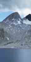
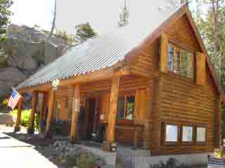
| Carson Pass Cabin, Carson Pass Highway 88 | Just South of the Carson Cabin on the PCT you enter the Mokelumne Wilderness. map |
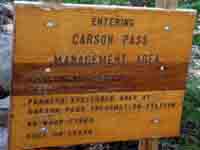
The Carson Pass Management Area |
|||||||||
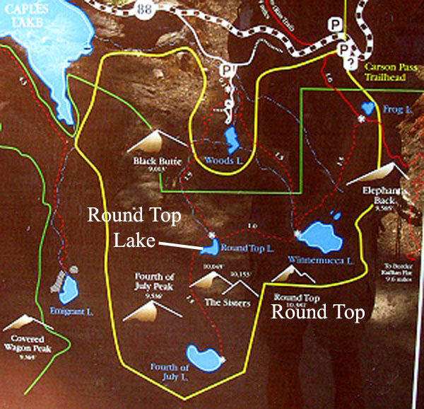
The Carson Pass Management AreaCarson Pass Management Area Backpacking Map CPMA information, federal website The Carson Pass Management Area administers a very small, but a very popular backpacking, hiking, and car camping area located to the Southwest of Carson Pass. Popularity is due to its extremely accessible beauty. This popularity triggered the creation of the Carson Pass Management Area and its highly limited permitting policy. The Carson Pass Management Area is incredibly regulated. Preserving the easily accessible stunning beauty here sparked the formation of the CPMA by El Dorado and Toiyabe National Forests to combat overuse. I was stunned (but not surprised) when they even went to the extent of actually assigning campsites. I understand that the problem comes down to the relationship between the small size of the Round Top hiking area, its easy accessibility from huge and growing population centers, and the large number of people already using it. A balance must be struck. Backpackers hiking out of the Lake Tahoe Basin Southbound on the Pacific Crest Trail, and PCT hikers in general have little concern with these CPMU restrictions. The Pacific Crest Trail route hikes across the Eastern edge of the CPMA, essentially going around the CPMU camping areas, except Winnemucca Lake. Winnemucca Lake is a 1.26 miles East of the PCT just a bit South of Carson Pass. Tahoe to Yosemite Trail backpackers hike across the heart of the Carson Pass Management Area. TYT hikers have the luxury of three distinct routes across the Carson Pass Management Area, each of which explores different aspects of this deservedly popular mountain.
Thus the camping restrictions in the Carson Pass Management Unit mainly affects us Tahoe to Yosemite Trail backpackers who want to camp in the heart of the CPMU as we hike through. The CPMU doesn't care if we hike through (with a permit!) but they might get cranky if we stop and camp. Here's how I approach camping at the CPMU during a long distance backpacking trip: First, I really want to enjoy the beauties of camping alongside Round Top Lake on my way South along the Tahoe to Yosemite Trail. It's the highest campsite since departing Meeks Bay. The problem is that permits are highly regulated in this area, and I've seen the Carson Pass Cabin claim only they could issue camping permits for the CPMU. This presents potential, but not insurmountable problems for long distance backpackers. The solution relies on excellent information and detailed planning. First, every long-distance permit issued from one National Forest must be honored by all subsequent NFs specified on the permit. Therefore it is very important that our permit specify "Round Top Lake " or "Fourth of July Lake" as one of our nightly campsites. We can go as far as specify a campsite number. Check the guide for details of campsites at Winnemucca Lake, Round Top Lake and Fourth of July Lake. These specifications on our permit will, they must be honored on our long distance backpacking trip through the Carson Pass Management Area, and every subsequent administrative area all the way down to the Whitney Portal, including Yosemite. It will not work for hiking Half Dome, if you are hiking down to the Yosemite Valley from Tuolumne Meadows. A separate Half Dome permit is required from Yosemite National Park. This is the only exception to the "It's cool if it's on your permit" rule that I am currently aware of. This strategy will not work for PCT hikers hiking on a PCT permit. PCT permits only allow hiking in the "PCT corridor" and NO TRAILS off the PCT. None at all. Very Few Campsites The CPMA laid out designated campsites to both limit the number of overnight permits and contain the damage of campsites to a few locations. This tiny area administers Winnemucca Lake (three sites), Round Top Lake (six sites), and 4th of July Lake (six sites). This shortage of sites and very heavy local backpacker traffic means that local backpackers, backpackers hiking in for a weekender, or on short local trip into or around the Carson Pass Management Area are lined up every weekend morning during the high Summer Backpacking season at the Carson Pass Cabin to get one of the few permits available. Not Cool! Remember, permits for short backpacking trips that start and stay within this small zone centered around Carson Pass can only be had at the Carson Pass Cabin, or the Amador Ranger Station when the Carson Pass Cabin is closed. (contacts) I don't suggest bypassing the logical permit restrictions at the CPMU, but I also can't see missing a night at Round Topo on the Southbound Tahoe to Yosemite Trail. Round Top and The Sisters is a high point. If we are coming in from the East we can check with the Carson Ranger District of Toiyabe National Forest Ranger Station about Eastern trailheads into Summit City Canyon as alternatives to entering the canyon over Round Top and The Sisters. The Carson Pass Management Area
Trailhead map of the Carson Pass Management Area: Yellow line marks the CPMA, the Green Line marks the boundary of the Mokelumne Wilderness.
Add your |
|||||||||
CPMA |
||
The Carson Pass Management Area
|
| Except Half Dome | Permits Forum |
Post up here if you are aware of any "double" permit zones in the Sierra Nevada Mountains between Lake Tahoe and Mount Whitney. Or here for anything pertaining to the El Dorado National Forest of interest.
The nice folks at the Carson Pass Management Area are very hard-ass about getting permits from them for trips into the CPMA, but they must honor permits issued by other National Forests.
If you want to camp at Round Top or Fourth of July Lake Lake, then make sure that you name it as a campsite on the permit you draw from the permitting authority of your starting trailhead.
The Pacific Crest Trail Route
through the
Carson Pass Management Area
Hikers on the Pacific Crest Trail just graze the Eastern boundary of the Carson Pass Management Area. The Pacific Crest Trail's route along the Eastern edge of the Carson Pass Management Area puts Round Top Lake 2.14 miles to the West of the Winnemucca Lake trail junction with the Pacific Crest Trail.
I figure that the PCT hiker's Eastern route across the Mokelumne Wilderness to or from Ebbetts Pass makes camping in the Carson Pass Management Area a secondary consideration to their daily quest for mileage, but it is still a possibility. As camping at Round Top Lake is off of the Pacific Crest Trail's route, this side trip will adds a round trip distance of 4.28 miles to your total mileage to and from the Pacific Crest Trail at the Winnemucca Lake trail junction. That distance can be shortened a bit.
The PCT Corridor Permit Rules prohibit PCT hikers from camping at Round Top Lake...
Northbound PCT from Winnemucca Lake
I do not hike East back to the Pacific Crest Trail through Winnemucca Lake. Instead I hike North and reconnect with the Pacific Crest Trail entering the Lake Tahoe Basin at the Carson Gap via either the Lost Cabin or the Woods Creek trail routes. The former is steeper and shorter, the latter gentler but longer.
Camping at Round Top Lake may be worth the extra efforts and miles for PCT hikers if you were not required to stop at the Carson Cabin to pick up a permit before camping there.
Round Top Lake offers camping at the highest altitude (9360 feet), with the best views, and has the nicest environment of all the campsites from Showers Lake (4.79 miles North of Carson Pass), to the series of lakes South of Blue Lake Road. Heck, I don't think Northbound Hikers are going to see anywhere to camp in the 9000 foot elevation range for the rest of the Pacific Crest Trail all the way to Canada. Correct me if I'm wrong, but Round Top will be Pacific Crest Trailers last high altitude campsite!
I enjoy Round Top Lake better than both of those other nearby places to camp, and many others apparently agree with me, judging by the amount of locals up there on a Summer weekend.
As most backpackers on the Pacific Crest Trail route are just scraping the Eastern edge of the Carson Pass Management Area on their way North, I figure it is unlikely that a serious Pacific Crest Trail hiker will actually veer 2.14 miles off the Pacific Crest Trail to camp at Round Top, let alone anywhere else off of the Pacific Crest Trail. This is due to the pressure of time and permit constraints. But I've seen it happen.
If we are hiking the Pacific Crest Trail route in sections or hiking the Lake Tahoe to Mount Whitney trails you have the flexibility to meander a bit off of our route. Take it. Put Round Top Lake on your permit.
I can't help but recommend planning a night at Round Top Lake into our itinerary. As I mentioned, it is the highest, if not the finest place to camp for miles in every direction.
Again, if you are hiking long distances on a standard federal permit, MAKE SURE that you name your Carson Pass Management Area campsite location on your Permit! (i.e., "Round Top Lake.")
I've never worried about naming one of their specific campsites on any of my through permits through here, though I guess I could. The sites are sequentially numbered at each location.
This tiny area administers Winnemucca Lake (three sites), Round Top Lake (six sites), and 4th of July Lake (six sites).
Carson Pass Management Area. As I repeat, a through hiker's subsequent National Forests, Wilderness, and National Parks must honor permits issued by other National Forests and Special Zones. If we did not name a campsite in the Carson Pass Management Area on our original permit we will have to hike to the Carson Cabin to see if an overnight permit is available.
This "naming" requirement is true of every busy location down the trail to the Whitney Portal. We make sure that we specifically name every location, especially locations in crowded location like Yosemite that we want to camp at on our long distance permit down to Mount Whitney.
As a through hiker, all permitting authorities, even the ones that are totally "booked up" must honor our permit.
I am not saying that we cannot camp in a place not named on our permit, (we will) but it is very important that all of the places that we plan on camping in high-traffic "Special Zones," such as the CPMA, Yosemite, and highly impacted places like "The Whitney Zone" should be specifically named on our permit. This will minimize troubles with the Local Ranger Man.
Better safe than disappointed.
CPMA |
Carson Pass Management Area for Short TripsThe Sad and Glad Facts about the Carson Pass Management Area Permits Well, not really crowded. They issue too few permits for crowding, thank common sense. But, it is busy up there. Hiking folks hiking by. Short distance backpackers into the Carson Pass Management Area are served on a first-come, first-served basis at the Carson Pass Cabin. The problem with this is that Carson Pass Management Area is very small and has a very limited number of campsites for backpackers. There are a grand total of 15 campsites in the whole Carson Pass Management Area. Winnemucca Lake has 3 sites, Round Top Lake has 6 sites, and Fourth of July Lake has 6 sites. Hey, it's a small and intensely beautiful place. Permits for these sites are not available over the phone, by mail, or by reservation. Permits for trips starting and staying in the Carson Pass Management Area will only be issued at the Carson Pass Cabin during summertime, and at the Amador Ranger Station when the Carson Pass Cabin is closed. Even with these restrictions the Carson Pass Management Area is busy. Round Top Lake is a premium beautiful high altitude lake very close to both paved roads and the over-grown populations of Lake Tahoe, the Valley, and the Bay Area. Busy-busy-busy. During Summer weekends the short distance backpacker hoping to camp on Round Top would be well served to have alternative backpacking plans, even if we can get to the Carson Pass Cabin when they open at (8am?). There may be no permits available for folk at the end of the line. An alternative would be to backpack North from Carson Pass into Meiss Meadow, (In the Lake Tahoe Basin Management Unit, which requires no permits at all!) and continue to the NW on the PCT-TY route towards Showers Lake, or to the NE down Christmas Valley towards Round Lake, and on to the South Upper Truckee trail head in Meyers. |
Local Backpacking Trailheads |
We can access the Mokelumne Wilderness from all Compass Points for short and medium distance local backpacking trips. Doing so requires we draw our permit from the National Forest administering that trailhead. There are three National Forests administering the Mokelumne Wilderness. Entering Mokelumne Wilderness from the East and Southeast Entering Mokelumne Wilderness from the North and Northwest If the Carson Pass Cabin is closed, the Amador Ranger Station will issue permits. Our Northwestern entry points stretch West from Carson Pass down Highway 108. These trailheads are also administered by the Amador Ranger District of the El Dorado National Forest. Hiking into the Mokelumne Wilderness from the Southwest |
Local Car Camping |
Free & Paid Car Camping near Woods Lake and Blue Lakes Car Camping on National Forest Land Car Camping and Access
|
South
into the
Heart of the Western Mokelumne Wilderness
in the
El Dorado National Forest
Carson Pass
|
||
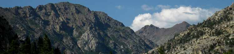
The Character of Terrain and Trail The backpacker on the Tahoe to Yosemite trail will be spending the next 16.45 miles in the El Dorado National Forest administered Mokelumne Wilderness hiking from the Carson Gap to Camp Irene. After cutting Southwest through the active heart of the CPMA over Round Top and The Sisters, we will drop down into very quiet Summit City Canyon on the South flank of Round Top and The Sisters. The Summit City Creek and Mokelumne River canyons are "typical," if anything so majestic can be called typical, of the breathtaking interface between massive granite canyons and volcanic valleys draining the Western Sierra flanks. Hiking over to the Southern flank of the volcanic Round Top from Round Top Lake reveals the massive granite bulk of Deadwood Peak making up the Southeast wall of Summit City Canyon. As we hike down to Fourth of July Lake and past into Summit City Canyon we can see that the Southern flank of Round Top and the Sisters, which makes up the North wall of the upper canyon, is completely composed of volcanic material, which we can see running East up to Forestdale Divide.
At Camp Irene the Tahoe to Yosemite route fords the North Fork of the Mokelumne River, which as I mentioned above, also marks our transition from the El Dorado into the Stanislaus National Forest. Trail conditions change dramatically. First and foremost for most backpackers is the fact that we are now back onto maintained trails, more or less. Of equal importance is the fact that we are once again crossing grand interfaces between the great gray granites of Summit City Creek and rusty red volcanic ridges dotted with hard black erosion sculptures standing straight up on pedestals of volcanic debris. The Mokelumne Wilderness extends a short distance further South from our ford of the N. Mokelumne River at Camp Irene, ending at the top of Mount Reba in the Stanislaus National Forest. The Southbound Tahoe to Yosemite route will enter our next Wilderness, the Carson-Iceberg Wilderness, just South of Lake Alpine. We will be hiking through the Stanislaus National Forest down to Highway 4, and far beyond. The Stanislaus administers both the Carson Iceberg and Emigrant Wilderness Areas that we will hike across on our way South down to the Yosemite National Park Boundary. The Western side of the Carson Iceberg Wilderness is administered by the Stanislaus National forest between Highway 4 and Highway 108. The Eastern section of the Carson-Iceberg Wilderness sits on the Eastern Flank of the Sierras, and is administered by the Toiyabe National Forest between Ebbetts and Sonora Passes. |
||
| last Lake Tahoe Basin Administrative Unit |
UP permitting authorities index |
next Toiyabe National Forest |
list of National Forests-Wilderness between
Lake Tahoe and Mount Whitney
Carson Pass Backpacking
|
|
I include information about the Toiyabe National Forest as it lays covers the Mokelumne Wilderness on the East flank of the Sierra Crest between Highways 88 and 4 while the El Dorado National Forest covers the Western. The Toiyabe National Forest administers the East flank of the Sierra Nevada from the East flank of the Carson Range off the East shore of Lake Tahoe all the way South through the Hoover Wilderness almost all the way South to Highway 120. Anytime we turn Left, East off the Southbound Pacific Crest Trail between Lake Tahoe to Tuolumne Meadows we are hiking into the Toiyabe National Forest. We will hike through the El Dorado and Stanislaus National Forests between Tahoe and Yosemite. South |
|
| West flank of the Sierra Nevada South of Carson Pass |
East Flank of the Sierra Nevada South of Carson Pass |
Fed website Main office (530) 622-5061 Monday through Friday 8:00 am to 4:30 pm
El Dorado CARSON PASS CABINCarson Pass, Highway 88 Open from mid-June to mid-September. 2013 Hours Call the Carson Pass Cabin during Summer for more information: Call the Amador Ranger Station for information off-season and when the Carson Cabin is closed: Federal Website: carson pass management area El Dorado National Forest Interpretive Association (ENFIA) Website: Carson Pass Cabin TahoetoWhitney: carson pass management area AMADOR RANGER DISTRICTDOUG BARBER, DISTRICT RANGER 26820 Silver Drive Phone: 209-295-4251 Office Hours: 8:00 AM - 4:30 PM Summer Schedule: Monday - Saturday from Memorial Weekend to Labor Day .Winter Schedule: Monday - Friday. Closed Holidays Entering Desolation Wilderness from the El Dorado National Forest. El Dorado NF Trailheads
|
Fed website Main office (775) 331-6444 Monday through Friday 8:00 am to 4:30 pm
Toiyabe CARSON RANGER DISTRICT(Eastern Sierra flank from Carson Range East and South of Lake Tahoe to Sonora Pass) Genny Wilson, District Ranger (775) 882-2766 Monday through Friday 8:00 am to 4:30 pm
BRIDGEPORT RANGER DISTRICT(Eastern Sierra flank from Sonora Pass to NE border of Yosemite, then South along E. edge of the Hoover Wilderness) Cheryl Probert, District RangerHC 62 (760) 932-7070 Winter: Monday through Friday 8:00 am to 4:30 pm
Best El Dorado National Forest Hiking Maps
|
|
||||
|
||||||
Highway 88
|
|||
| Western Sierra TYT |
Eastern Sierra PCT |
El Dorado National Forest
Federal Website Information
The Western Route of the Tahoe to Yosemite Trail
El Dorado National Forest
Home Page
El Dorado National Forest
Ranger Districts Map
El Dorado National Forest
Carson Pass Management Area Information
El Dorado National Forest
Mokelumne Wilderness
El Dorado National Forest Paper Maps
El Dorado National Forest
Interpretive association
Toiyabe National Forest
Federal Website Information
The Eastern Route of the Pacific Crest Trail
(TW trail guide info: Toiyabe National Forest)
Toiyabe National Forest
Home page
Toiyabe National Forest
Carson Ranger District Information
Toiyabe National Forest
Bridgeport Ranger District Information
Toiyabe National Forest
Mokelumne Wilderness
Toiyabe National Forest Paper Maps
Maps
(for sale)
| Mokelumne Wilderness NF PDF Trail Map |
Mokelumne Wilderness TW Trail Guide Map |
Entering the Mokelumne Wilderness from the West or Southbound along the Sierra Crestline through Carson Pass requires we obtain our permits from the El Dorado National Forest. Entering the Mokelumne Wilderness from the East or Northbound along the PCT through Ebbetts Pass requires we obtain our permits from the Toiyabe National Forest. |
| NORTH Lake Tahoe Basin Management Unit |
permitting authorities index |
SOUTH Toiyabe National Forest |
High Sierra National Forests, Parks, and Wilderness Areas
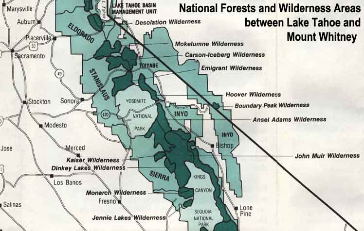 |
| Map Credit: Forest Service, Pacific Southwest Region, "A Guide to National Forest Wilderness in California." |
Large Map of High Sierra Forests and Wilderness
List
ALL National Forests-Wilderness between
Lake Tahoe and Mount Whitney
Contact
Alex Wierbinski
Our guide to the Sierra Crest, including the Tahoe to Yosemite, the Pacific Crest and the John Muir Trails