Lembert Dome in Tuolumne Meadows. Lake Tahoe to Mount Whitney: Your Backpacking Guide to the High Sierras Cathedral Peak.
Lower Cathedral Lake.
Lembert Dome
Lower Cathedral Lake sunset.
Cathedral Peak


High Sierra
Backpacking

Main
Trail Guide
TRAILHEAD
 
High Sierra
MAGAZINE
 
ALL BLOG


The Trails

Guide
Maps
Miles/Ele
Permits
Resupply
Forum


Current Weather Conditions

Weather Notes
Northern High Sierras
Central High Sierras
Southern High Sierras
 

Gear

Gear List
Gettin Started
Layering
Discussion
 
Testing yourself and your gear
 
Gear Reviews


top of page

Backpacking
Lake Tahoe to
Mount Whitney

Trail Guide
INDEX


Tuolumne Meadows
to
Yosemite Valley
The
"Backwards"
John Muir
Trail


Part I
The Golden Triangle
from

Tuolumne Meadows
to
Yosemite Valley


Languages

Translate


Trail Skills

The trail
Navigation
Camp skills
Paper Maps
Off the trail
Scrambling


Mountain
Safety
Safety Topics
Safety
Incidents
Mosquito Info
Skeeter News


Food

Resupply
FORUM
Food


Planning

40 Days to Whitney


Introduction Tahoe to Whitney
 
Introduction Tahoe-Yosemite


Trail Arts

Art of walking
 
Physical
Preperation


More
Information

Links


News
and
Science


Books


Trail Stories


Photo
Catagories


Social
Trail Culture


Groups


Terms and Conditions of Use


top of page

Backpacking Central
Yosemite National Park
NORTH NEXT SECTION
GOLDEN TRIANGLE
SOUTH


North
Standard
Tahoe-Whitney


TYT & PCT


Sonora
Pass

to
Tuolumne
Meadows


Yosemite Permits


Part I
Golden Triangle


Tuolumne Meadows
to

Yosemite Valley
BACKWARDS
JMT
(below)


Part II
Golden Triangle

ALT ROUTE
from
Yosemite Valley
to
Lyell Canyon

Yosemite Valley
back
to the

Southbound JMT
in
Lyell Canyon
via
Vogelsang


South
Standard
Tahoe-Whitney


JMT & PCT


Tuolumne
Meadows

to
Reds
Meadow


Below
Tuolumne Meadows
to
Yosemite Valley
INDEX


Part I
of the
Golden Triangle

TRAIL GUIDE INDEX

Tuolumne Meadows
to
Happy Isles Trailhead
in
Yosemite Valley


INTRODUCTION
Part I
of the
Golden Triangle

See the Forum


Tuolumne Meadows to Yosemite Valley
TRAIL GUIDE INDEX

INTRODUCTION

Off the Crest
The Golden Triangle is an alternative route off the Sierra Crest hiking down to and through Yosemite Valley as part of our backpacking the Sierra Crest Trails from Tahoe to Whitney.
Call it a significant detour off our Crestline route.

Into the Valley
The Golden Triangle alternative route takes us down to Yosemite Valley following the JMT route. We'll hike a different route back up to the Sierra Crest through Central Yosemite to resume the John Muir Trail in Lyell Canyon 5.6 miles South of Tuolumne Meadows.

Social Mecca
We'll hike the John Muir Trail "backwards" down off the Sierra Crestline to the Valley for a couple of days of camping in Camp 4, or maybe hang out with some of the employees. We'll mingle with the crowds of touristas, meet some of the cool employees of DNC, some cool Yosemite National Park employees, and of course meet as many of the backpackers and climbers who gather here every Summer from every part of the world as possible.


Yosemite Valley's
Traditional Backpacker-Climber Camp
Camp 4 rules, Yosemite Valley, Yosemite National Park.


Back to the Sierra Crest
Yosemite Valley back to John Muir Trail
in
Lyell Canyon
via
Vogelsang Pass

Departing the Valley to return to the Sierra Crest brings us back through Happy Isles to follow the JMT for 4 steep miles climbing up to Little Yosemite. From Little Yosemite Valley we break off the route of the JMT hiking up the Merced River to Merced Lake. From Merced Lake we access the trails over Vogelsang Pass.
From Voglesang High Sierra Camp we can either intercept the Southbound JMT in Lyell Canyon 5.6 miles South of Tuolumne Meadows or hike through Tuolumne Pass directly to Tuolumne Meadows.

That's the Golden Triangle.


Golden Triangle Mileages
My tentative figure for the distance from Tuolumne Meadows to Yosemite Valley and back to the JMT in Lyell Canyon via Voglesang Pass is 49.2 miles.

This figure is obtained using the 27.3 miles figure given for the distance to Tuolumne Meadows on the Happy Isles trail sign, rather than using the 20.9 miles given by the trail sign along the JMT behind the TM visitor center.

We add that 27.3 miles to the 27.5 miles to Yosemite Valley cited by the trail sign at the Lyell Canyon Trailhead to obtain the total trailhead to trailhead distance of The Golden Triangle route departing and returning to Tuolumne Meadows via Yosemite Valley at 54.8 miles.

We reduce this by the 5.6 miles from the Lyell Canyon Trailhead to where the trail down from Voglesang High Sierra Camp intersects with the John Muir Trail. This means that The Golden Triangle adds 49.2 miles to the distance of our Tahoe to Whitney backpacking trip.


Posted Miles
Sign Below, in Tuolumne Meadows:
20.9
miles down the JMT to Happy Isles
Sign at Happy Isles in Yosemite Valley:
27.3
miles to Tuolumne Meadows

As we build the guide South we will reconcile the various differing miles figures cited on different trail sign posts along the same trail.

top of page


Trail Guide Index
Golden Triangle
I

Tuolumne Meadows
to
Yosemite Valley
backwards
on the JMT

Trail Guide Pages

Tuolumne Meadows to Cathedral Lakes

Cathedral Lakes to Sunrise High Sierra Camp

Sunrise HSC to Little Yosemite Valley

Little Yosemite Valley into Yosemite Valley


Miles and Elevations

Tuolumne Meadows to Yosemite Valley


7.5 minute Maps

Tuolumne Meadows

Yosemite Valley


30 minute Map

Central Yosemite

Map Index

Tuolumne Meadows to Yosemite Valley


Resupply North

Tuolumne Meadows

Yosemite Valley


Resupply South

Reds Meadow-Mammoth Lakes


Permits

Yosemite National Park

top of page


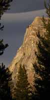
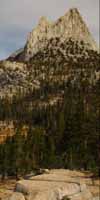
John Muir Trailhead sign at the Wilderness Boundary in Tuolumne Meadows.
John Muir Trailhead sign in Tuolumne Meadows.
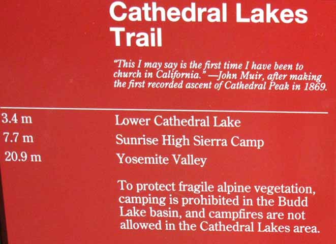
Note that the distance to Tuolumne cited on the trail sign at Happy Isles is 27.3 miles.


THE GOLDEN TRIANGLE

This is the guide index page for one leg of an amazing alternative route off of our typically High Sierra Crestline route hiking South from Lake Tahoe to Mount Whitney.

Though our standard route from Tahoe to Whitney walks the majority of the John Muir Trail on our way down the Sierra Crestline to Mount Whitney, we miss the beginning of the JMT climbing out of Yosemite Valley.
In fact, our basic PCT-JMT route along the Sierra Crestline from Tahoe to Whitney stays up high and goes around the whole Merced Drainage far above and away from Yosemite Valley.
We can fix that "slight" omission by adding the "Golden Triangle" to our Tahoe to Whitney backpacking trip. This is the index page for the first of two the legs of trail composing The Golden Triangle.

This first section of the Golden Triangle starts out by hiking from Tuolumne Meadows down to Yosemite Valley "backwards" down the John Muir Trail.

The next section brings us up from Yosemite Valley back to the John Muir Trail in Lyell Canyon by a different route than the JMT we hiked down. The shape of our route roughly relates to a triangle. As Yosemite is the Gold Standard of High Sierra beauty, I call this route "The Golden Triangle."
Our return hike will begin through Happy Isles with the JMT, but we will turn off the JMT at Little Yosemite to find our way back to the Southbound JMT in Lyell Canyon via Merced Lake and over Voglesang Pass.
Our hiking map of Tuolumne Meadows shows the beginning of the JMT "Golden Triangle" route down towards Yosemite Valley and the end of our Golden Triangle route over Voglesang Pass.
The Golden Triangle ends where we reengage the Southbound JMT in Lyell Canyon just South of Tuolumne Meadows to continue our Southbound hike on the JMT to the Whitney Portal.

This index handles the hike "backwards" down the JMT from Tuolumne Meadows to Yosemite Valley. The next index page South covers the second leg of The Golden Triangle, the hike from The Valley to the JMT in Lyell Canyon via the Merced River and Voglesang High Sierra Camp.

This is a great backpacking trip around the heart of Yosemite on its own. If we add the hike across the North Yosemite Backcountry from Highway 108 to the Golden Triangle, it is a fantastic tour of the Northern and Central parts of Yosemite National Park. If we add the hike over Donohue Pass down to Reds Meadow, our hike covers the majority of the Yosemite Wilderness and walks across the center of the Ansel Adams Wilderness to its South.

I really enjoy The Golden Triangle as a rather unique section along my Tahoe to Whitney hikes.


Trail Guide
INDEXES
NORTH & SOUTH

North Index
TYT-PCT
Tuolumne Meadows Option
JMT-PCT
South Index
Golden Triangle to JMT

Sonora Pass
to
Tuolumne Meadows

Tuolumne Meadows
to
Reds Meadow

Yosemite Valley
to
JMT in Lyell Canyon

Post up your experiences, information, and your questions and comments about backpacking into and out of Yosemite Valley.

Comments

top of page


Tuolumne Meadows to Yosemite Valley
ALL TRAIL GUIDE RESOURCES

Trail Guide Pages


7.5 minute Maps

Tuolumne Meadows

30 minute Maps


N Lake's

North:  Sonora Pass to Tuolumne Meadows                                              South: Tuolumne Meadows to Reds Meadow

Tuolumne Meadows
to
Yosemite Valley

The John Muir Trail

An Alternative Route for long distance High Sierra Backpackers up and down the Sierra Crestline to further explore Yosemite National Park.


THIS PAGE IS UNDER CONSTRUCTION: STAY TUNED FOR MUCH MORE!

COME ON BACK NOW, 'YA HEAR?


Miles and Elevations

Comments

top of page


Backpacking Trail Guide
INDEX

TYT-PCT
North

Sonora Pass
to
Tuolumne Meadows

Compass and map directions are the best.

Backpacking Trail Guide
INDEX

JMT-PCT
South

Yosemite Valley
back
to the

Southbound JMT
in
Lyell Canyon


Backpacker Forums

Have a great trip or story to relate about Yosemite or in the Sierra Nevada?
A fine piece of gear? Or gear that failed? An excellent backpacking tip?

Post it on
TahoetoWhitney.Org

Above we come to the Front Page of the High Backpacking Trails and Topics Forums. Below we break the forums down into categories:

High Sierra Trails High Sierra Topics

The Trails Forum acts as your place to put up input, comments, relate your experiences, or ask questions about each segment and spot along the length of our combined TYT-PCT-JMT trails.

The Forum is your place to supplement the trail guide.

Anyone can post text comments in the existing forums, but only members can post up new topics, along with images, maps, and formatting.

Become a Member

If you have experiences, comments, questions, or pictures and videos of the John Muir Trail from Tuolumne Meadows down to Yosemite Valley, post it up here as an unknown hiker or as a member:

Forum Section
The Golden Triangle
Forum Segment
Golden Triangle
Tuolumne Meadows to Yosemite Valley

Comments


North:  Sonora Pass to Tuolumne Meadows                                              South: Tuolumne Meadows to Reds Meadow
Trailhead
Contact
Alex Wierbinski

top of page

Frosted Backpack

Backpacking Lake Tahoe to Mount Whitney

Your Guide to the High Sierra Crest, including the Tahoe to Yosemite, Pacific Crest, and John Muir Trails

Snug tent after Snow Storm
© Lake Tahoe to Mount Whitney: Crown Jewel of the Pacific Crest Trail