High Sierra
Backpacking
Trail Guide
Forums
Sierra
Weather
Gear
Lake Tahoe Basin Management Unit
"LTBMU"
PERMITS
for
local and long distance backpackers
Languages
Trail Skills
Mountain
Safety
Safety
Incidents
Food
Planning
40 Days to Whitney Introduction Tahoe-Yosemite
Trail Arts
More
Information
News
and
Science
Social
| Permitting Authorities Index |
El Dorado National Forest |
Toiyabe National Forest |
Stanislaus National Forest |
Yosemite National Park |
other trips | links & maps |
contacts |
| Sequoia-Kings Canyon National Park |
Lake Tahoe Basin Management Unit
"LTBMU"
Quick Links
Mountain Safety Issues
|
|||||||
Quick ReferencesA Quick Context Therefore our focus below is on the Desolation Wilderness and Meiss Country Roadless Area along the Western shore and around the Southwest corner of the Lake Tahoe Basin and its Federal Management Unit. This Tahoe to Whitney Trail Guide can be used to plan local backpacking trips around both Desolation and Meiss Country Roadless Area as well as the much longer Tahoe to Yosemite and Tahoe to Whitney backpacking trips backpacking South on both the TYT and PCT routes. In either case we have to deal with the LTBMU to get our required permits.
Forest Service offers this 13 page PDF
All Desolation Wilderness Permits Information
Al's Long-Distance Backpacking Permit Advice
QUICK REFERENCE INFORMATION
|
| comments | top of page |
The Tahoe to Yosemite Trail |
||||
| Hiking South out of the Lake Tahoe Basin Southbound hikers on the Tahoe to Yosemite Trail will be in the LTBMU for 41.32 miles from the trailhead at Meeks Bay until climbing out of the South Upper Truckee Headwaters to exit the Lake Tahoe Basin through the Carson Gap in the far Southern corner of the Tahoe Basin. 11.5 miles Southwest of the Meeks Bay Trailhead the TYT joins the PCT and TRT routes in the far Northern end of Desolation Wilderness. The TYT, PCT, and TRT share the trail South across the length of Desolation Wilderness and more than half of the Meiss Country Roadless Area to where the TRT turns Northeast at Meiss Cabin and our still unified TYT and PCT proceed South to exit the Tahoe Basin through the Carson Gap. Miles and Trails Meeks Bay to Carson Gap Meeks Bay to Echo Summit The unified PCT and TYT cross 29.82 miles of the Tahoe to Yosemite's route's 41.32 miles from Meeks Bay to the Carson Gap together through dense forests, over great granite passes, and around the deep blue lakes bounding the Western shore of Lake Tahoe in Desolation Wilderness and the Meiss Country Roadless Area. TYT-PCT South from the Edge of the Lake Tahoe Basin Our unified PCT/TYT route divides into two very different trails with very different characters South of the Lake Tahoe Basin. Miles and Elevations South from the Lake Tahoe Basin Highway 88 to Highway 4
Highway 88 to Highway 4
South from the Lake Tahoe Basin The only variation between the Tahoe to Yosemite and Pacific Crest Trails across North Yosemite is where the TYT takes a different route over Bailey Ridge than the PCT. The TYT crosses via Tilden Lake up higher on the ridgeline than the PCT's lower route around Wilmer Lake.
The Permit Situation on the Ground This has induced Desolation Wilderness to institute a web-based permit registration system that is basically the same one used by Yosemite and Hoover Wilderness. These permit systems are administered through the Recreation.Gov and SierraWild sites.
Reservations Required? Fifty percent of the permits allotted for Desolation Wilderness zones and trailheads are made available for reservations six months in advance, while the other fifty percent of permits for a given date are available at the permit stations on the date of departure. It is wise to assume that mid-Summer weekends and holiday dates are highly sought-after through both the reservation system and at the trailheads.
So I call the main office in South Lake Tahoe, and they've always cut me a break and sent me the TYT wilderness and fire permits covering the complex routes I hike along the Tahoe to Yosemite Trail and on down to the Whitney Portal, through the mail as far in advance as possible. A big cause of my concern is the confusion of the reservation system with permits that extend far outside My other reason is that it is really hard for me to get to one of their permit stations to pick up a pre-arranged permit while taking public transportation and hitch-hiking to the trailhead. It is even more difficult for me to expect to get a permit the day I am leaving at the Meeks Bay Permit Station. That may not happen, due to excess hiker traffic exceeding zone and trailhead quotas. So I call them up and sweet talk them into sending me my custom, complex Tahoe to Yosemite or Tahoe to Whitney permit through the mail. Hitch-hiking there, and arriving late in the day expecting to get a permit may well put me over the daily "quota" out of that trailhead into this hiking zone.
I only obtain custom permits from the Ranger Station for long backpacking trips leaving the Tahoe Basin. We must use the standard reservation system if our trips through the Meeks Bay Trailhead remain within the Tahoe Basin. Our Tahoe to Whitney permit needs to specifically cite around fifty campsites in every national forest, park, and wilderness between Tahoe and Whitney. One of the front office folks usually fills me out a custom permit over the phone or I send them my itinerary. This saves a tremendous amount of hassle with the online permit system, and at the trailhead.
Fee Area The LTBMU waives their permit fees for trips starting in Desolation Wilderness that cross more than one National Forest. If we are only staying in Desolation Wilderness or remaining within the boundaries of the LTBMU we pay a fee. If we are hiking South into the El Dorado and points further South, out of the LTBMU, permits are free. Yeah! Many Desolation Wilderness Trailheads
Standard Practice? The ability to obtain reservations-permits from Desolation Wilderness will factor into, and ultimately be the final factor determining our start date. Our permit is the final product of working out or food needs, our itinerary, and our resupply plan. Once we decide to begin our hike to Tuolumne Meadows or Mount Whitney through Desolation Wilderness we should call the LTBMU and inquire about long distance permits out of Meeks Bay. Long and short distance backpackers both need to take the popularity and resulting permit restrictions and quotas at Desolation Wilderness into consideration when planning the TYT out of Desolation, especially if you are hiking short backpacking trips remaining within Desolation. Continuing South of Desolation Wilderness
Fire and Permits That was before this new, much drier seasonal weather pattern fully emerged. Over the past few years the forests and parks up and down the Sierra Nevada have moved towards completely prohibiting fires. Though I don't make fires, I think it would be unfair to impose a blanket fire ban across the High Sierra. Most folks see the campfire as an icon of backpacking, and would be disappointed without one. I think that's crap, but that's just my opinion. I prefer darkness. Darkness allows full observation, while fires do no more than blind you, and draw outside attention to the fire. Fire bans should only begin when Spring's wetness departs. People are freaking out and making laws to make up for over-development, People think they make a few laws, then continue on with "business as usual." That is not going to work. All the forests we have dried out are going to burn, and that's all there is to this issue. None of the ill-intentioned and stupid things we do to each other and the Earth do not just go away. These actions collect up in ecosystems as they do in cultures, until they can take no more, and either we stop our stupidity, or our ecosystems and cultures will radically change or break.
The Long View
LTBMU Staff is Real Helpful I have uniformly talked to really really nice folks manning the phones in the Lake Tahoe Basin Management Unit's various offices. Nice folks who want to help you get your permit. Remember, we catch more flies with honey than vinegar. Remember, folks judge all backpackers by the behavior of each.
|
||||
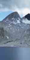
The Lake Tahoe Basin Management Unit is the permitting authority for all long distance backpacking trips originating from the Meeks Bay, Echo Summit, or the South Upper Truckee trail heads described in this trail guide. These are excellent options for beginning long-distance backpacking trips South to Yosemite and on to Whitney, or for short trips around the Lake Tahoe Basin. (view trailheads) You can start your long distance Southbound backpacking trip from your favorite trailhead in the Lake Tahoe Basin! If you start your Tahoe to Yosemite or Tahoe to Whitney trip anywhere in the Lake Tahoe Basin it is a valid "Tahoe to..." (fill in your destination) backpacking trip. We don't have to start at Meeks Bay to hike from Tahoe to Yosemite along the classic route. We can put together our own custom routes from Lake Tahoe to Yosemite tying together different bits of the TYT and PCT routes, and further South beyond Tuolumne Meadows we can mix up the JMT with the PCT and other alternative routes hiking South from Tuolumne down to Mount Whitney. But it's going to be a heck of a lot of real fun. The LTBMU is a single authority and is not sub-divided into individual Ranger Districts, as are most National Forests. Backpackers enter the LTBMU when they enter the Tahoe Basin. |
LTBMSierraWild Recreation.GOV Recreation.GOV Desolation Wilderness Permit Notes and Information Desolation requires day hiker and overnight backpacker permits year round. Desolation Wilderness requires fire permits for camp stoves and lighters too. Desolation Wilderness is a fee area for backpackers!
|
||
| Within the LTBMU | ||
11.5 miles South of Meeks Bay the Tahoe to Yosemite Trail intersects with the Tahoe Rim and Pacific Crest Trails, which will accompany our Tahoe to Yosemite Trail route South to Meiss Cabin and the Carson Gap, respectively. 30.71 miles South of Meeks Bay the Tahoe to Yosemite, the Pacific Crest and the Tahoe Rim Trails exit Desolation Wilderness through Lower Echo Lake. Two miles south of Echo Lake the Southbound backpacker enters the Meiss Country Roadless Area when passing through Echo Summit at Highway 50 on the way South to exit the Tahoe Basin through the Carson Gap. At the Carson Gap the Southbound hiker exits the Lake Tahoe Basin after 41.32 miles of hiking through the Lake Tahoe Basin Management Unit, if you started your trip at the Meeks Bay trailhead. Wherever you started, passing South through the Carson Gap marks the end of your hike in the Tahoe Basin.
On Down the TrailPassing South through the Carson Gap the Southbound backpacker on the Pacific Crest Trail will be entering the Toiyabe National Forest administered Eastern section of the Mokelumne Wilderness (mostly, though we will also hike through a bit of the El Dorado at first), while the Tahoe to Yosemite backpacker will enter the El Dorado NF administered Western section of the Mokelumne Wilderness for the majority of the distance to Lake Alpine. But first, both Southbound routes pass through the tiny Carson Pass Management Area when exiting the LTBMU along each of their respective routes. If you're backpacking trip South on the Pacific Crest or Tahoe to Yosemite Trail routes start at the Carson Pass Management Area, you should consult with the Amador Ranger District of the El Dorado National Forest prior to departing. Here's some basic information about the Carson Pass Management Area. The backpacker starting the Tahoe to Yosemite Trail South from the Carson Pass Management Area should consult the El Dorado National Forest, if all else fails, as the El Dorado NF manages the Amador Ranger District. OverallThis Trail guide, besides covering the Pacific Crest Trail between Lake Tahoe and Mount Whitney, also explores the Tahoe to Yosemite Trail, the John Muir Trail, and the various trail options that parallel those routes between Lake Tahoe and Mount Whitney that you may find interesting. As you can see, backpackers have many trail options hiking South out of Lake Tahoe to Mount Whitney. Hiking options continue to open up down the trail. RememberAlthough parts of the LTBMU do not even require backpacking permits for trips within their limits, all long distance backpackers must obtain a valid permit from their starting trail head's Administrative Unit, the LTBMU in this case, even if the area you start from does not require a permit. Your long trip does require permitting. Permits are required for legal travel down the trail after you exit the LTBMU and begin to pass through all of the subsequent Wildernesses and National Forests your happy feet will hike through on your way to Yosemite and on down to Mount Whitney. I only say this because one time it took a long while to explain to the LTBMU person on the phone that I really did need a permit for my long trip starting out of the Meiss Country Roadless Area, though I did not need permitting for the short time I would be hiking across Meiss Country. They sent me the required permit.
|
||
| NOTE All AREAS IN THE LTBMU REQUIRE FIRE PERMITS FOR CAMP STOVES |
| back: permitting authorities index | all Lake Tahoe trail heads | next: El Dorado National forest |
The Main Attractions
in the
Lake Tahoe Basin Management Unit
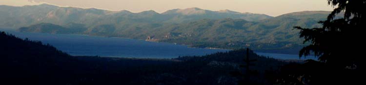
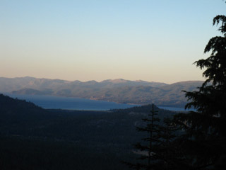
Lake Tahoe Basin |
The |
||||
Meeks Bay Trailhead We cover two other trailheads feeding the TYT, PCT, and TRT in the Southwestern Tahoe Basin.
These are the Meeks Bay, Echo Summit, and South Upper Truckee Trailheads.
The main reason for starting in the Tahoe Basin is that the Sierra Nevada wrapping around the West Shore of Lake Tahoe is the Northern bookend of the High Altitude Sierra Nevada Mountain Range. Altitudes drop precipitously North of the Lake Tahoe Basin. The North Sierra The Whole Enchilada The vast majority of the high altitude portion of the Sierra Nevada Mountain Range lays between Tahoe and Whitney. Various Start Points Yet the Meeks Bay Trailhead is a classic start point for the classic route of the TYT. Tahoe Trailheads on a Google Road Map The Point? Nonetheless, all of our Lake Tahoe trail heads originate in the Lake Tahoe Basin Management Unit. The Permits When the long boring recording begins you can press "1,"then "1" again to go directly to a human with backpacking & Wilderness information.
Desolation Wilderness Desolation Wilderness is not cheap! If your backpacking trip spans more than one National Forest the LTBMU does not charge for permits that start in the Desolation Wilderness. Yeah! When the long boring recording begins you can press "1,"then "1" again to go directly to a human with backpacking & Wilderness information.
Fed Website Information
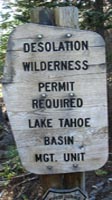
Meiss Country Roadless Area Though backpacking permits are not required, fire permits are required for the use of a stove in Meiss Country. Going Long Permits must be obtained from the Administrative Authority of their starting trailhead. Except Half Dome. The LTBMU administers all the terrain around Lake Tahoe including any terrain that drains into Lake Tahoe. There is more information about Desolation Wilderness and Meiss Country to the right.
|
Desolation Wilderness
|
| comments | top of page |
Contact Information, Numbers, Links, Office Locations and
PERMIT INFORMATION
for
DESOLATION WILDERNESS
Lake Tahoe Basin Management UnitOffice Locations/Contact Information |
||||||||
Everything
Review all the information above before ordering your permits!
National Forest Complete Guide, PDF
Lake Tahoe Rangers
Federal Web Site
|
||||||||
South Lake Tahoe Rangers
Lake Tahoe Basin Management Unit
|
||||||||
| comments | top of page |
North Shore Rangers
LTBMU North Tahoe
Forest Service Office
855 Alder Ave.
Incline Village,
NV 89450
(775) 831-0914
Lake Tahoe Basin Management Unit
FED RESOURCES
Maps, Miles, Elevations
National Forest Service
Map Links
Lake Tahoe Basin Management Unit
Maps Page
The Whole LTBMU pdf
A reasonable Trail Map. HUGE FILE.
South Lake Tahoe pdf
Roads, Campgrounds, basic boundaries.
Desolation Wilderness Map, pdf
Zones and Trailheads for Quotas.
Meiss Country Roadless Area map pdf
Lousy Fed Trail Map.
Tahoe to Whitney
Trail Guide
Maps
Desolation Wilderness
30 minute custom USGS TW Trail Map
Meiss Country Roadless Area
7.5 minute custom USGS TW Trail Map
Lake Tahoe Basin
Backpacking Map Index
Miles and Elevations
top of page
| South Lake Tahoe Backpacker Resources |
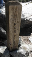
| The Marker for the Main Ranger Station in South Lake Tahoe is to the left of the marker pointing at the Hwy 50 emblem. |
Other Great Trips in the LTBMU: |
We don't have to just backpack through the LTBMU to points further South. We can enjoy many years of short backpacking trips through the many miles of beautiful forests, valleys, mountains and meadows that surround Lake Tahoe. Opportunity Walks Tahoe Rim Trail Organization
Echo Summit Trailhead
South Upper Truckee Trailhead
Desolation Wilderness
|
High Sierra National Forests, Parks, and Wilderness Areas
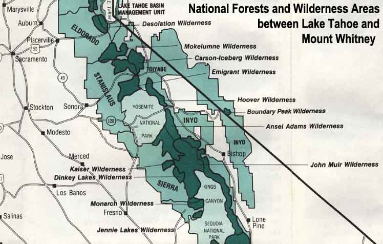 |
| Map Credit: Forest Service, Pacific Southwest Region, "A Guide to National Forest Wilderness in California." Large High Sierra National Forest Map |
Explore the Lake Tahoe Basin!
Our guide to the Sierra Crest, including the Tahoe to Yosemite, the Pacific Crest and the John Muir Trails