
The Trails
Guide
Maps
Miles/Ele
Permits
Resupply
Forum
Current Weather Conditions
Weather Notes
Northern High Sierras
Central High Sierras
Southern High Sierras
Gear
Gear List
Gettin Started
Layering
Discussion
Testing yourself and your gear
Gear Reviews
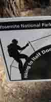
Tuolumne Meadows to Yosemite Valley
Miles and Elevations
John Muir Trail
BACKWARDS
Miles and Elevations
Backpacking
Central Yosemite Wilderness
Backpacking
Miles and Elevations
on the
John Muir Trail
to
Yosemite Valley
Languages
Translate
Trail Arts
The art of walking
Physical Preperation
Trail Skills
The trail
Off the trail
Scrambling
Maps
Navigation
Camp skills
Food
Resupply
Food
Other
Photo Catagories
Trail Stories
Trail Culture
News and Science
Links
Groups
Books
MILES TYT-PCT |
MILES ALT Valley to Lyell Canyon |
MILES JMT-PCT |
MILES PCT-TYT |
REGIONAL JMT-PCT & |
TRAIL |
MAPS |
ALL |
TRAIL |
Yosemite Wilderness
Miles & ElevationsTahoe to Yosemite Trail
|
| A "Must" Read On Miles and Elevations in the High Sierra |
Zero Point and Accuracy |
Trail Guide
INDEX
Golden Triangle I
Tuolumne Meadows to Yosemite Valley
21.8 miles
| Location | Elevation | Mileage | |
| Tuolumne Meadows Store, Grill, & P.O. |
8575 | 0 | |
| +15 | .62 | ||
| West End of Campground Road Unicorn Creek |
8590 | .62 | |
| +30 | .32 | ||
| Visitor Center
Junction on JMT Mileage Sign Post |
8620 | .94 | |
| -30 | .52 | ||
| Wilderness Boundary Junction on JMT Mileage Sign Post |
8590 | 1.46 | |
| +840 | 2.59 | ||
| Lower Cathedral Lake Junction Lake Campsites: .5 mile spur trail Mileage Sign Post |
9430 | 4.05 | |
| +170 | .54 | ||
| Upper Cathedral Lake Sign Campsites |
9600 | 4.59 | |
| +120 | .50 | ||
| Cathedral Pass | 9720 | 5.09 | |
| +100 | 1.40 | ||
| Under Base of Colombia Finger | 9820 | 6.49 | |
| -300 | 1.14 | ||
Upper Long Meadow Junction |
9520 | 7.63 | |
| +/- 00 | .81 | ||
| Bottom of Long Meadow Junction near Sunrise HSC Mileage Sign Post |
9520 | 8.44 | |
| +160 | 1.49 | ||
| High Point Above Sunrise Creek | 9680 | 9.93 | |
| -1130 | 1.23 | ||
| Upper Sunrise Creek Ford Campsites |
8550 | 11.16 | |
| -350 | .95 | ||
| Rim of Merced Canyon | 8200 | 12.11 | |
| -200 | .78 | ||
| Forsyth Trail Junction Mileage Sign Post |
8000 | 12.89 | |
| -110 | .18 | ||
| Merced and Washburn Lakes Trail Junction & Mileage Anomaly Mileage Sign Post |
7890 | 13.07 | |
| -410 | 1.11 | ||
| Lower Sunrise Creek Ford Campsites |
7480 | 14.08 | |
| -260 | .75 | ||
| Clouds Rest Trail Junction Campsites Mileage Sign Post |
7220 | 15.83 | |
| -200 | .52 | ||
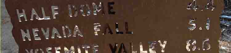
| Half Dome Trail Junction Mileage Sign Post |
7020 | 16.35 | |
| -880 | 1.41 | ||
| Little Yosemite Valley Junction To Campsites Trail Junction |
6140 | 17.76 | |
| +/- 00 | .15 | ||
| Little Yosemite Backpacker Camp Campsites Mileage Sign Post along Merced River |
6140 | 17.91 | |
| -20 | .46 | ||
| Junction on West End of Little Yosemite Valley |
6120 | 18.37 | |
| -150 | .58 | ||
| Uppermost Mist Trail junction Ranger White Boards Mileage Sign Post |
5970 | 18.95 | |
| -40 | .14 | ||
| Nevada Falls Bridge | 5930 | 19.09 | |
| +70 | .20 | ||
| Glacier Point Trail Junction Mileage Sign Post |
6000 | 19.29 | |
| -510 | .93 | ||
| Clarks Point-Middle Mist Trail Jnc Mileage Sign Post |
5490 | 20.22 | |
| -900 | .73 | ||
| Lowest Mist Trail Junction Mileage Sign Post |
4590 | 20.95 | |
| -190 | .14 | ||
| Merced River Footbridge | 4400 | 21.09 | |
| -365 | .71 | ||
| John Muir Trailhead Mileage Sign Post |
4035 | 21.8 |
TYT-PCT
|
|
| JMT SOUTH Tuolumne Meadows to Reds Meadow Miles and Elevations |
JMT ALT-ROUTE SOUTH Yosemite Valley to Lyell Canyon via Vogelsang Miles and Elevations |
|
| top of page |
Miles North: Sonora Pass to Tuolumne Meadows Miles South: Yosemite Valley to Lyell Canyon
Mileage Notes Measurement Yosemite's steel-cut mileage signs at trail junctions between Yosemite Valley and "Tuolumne Meadows" cite the Tuolumne Lodge and its associated High Sierra Camp as its measured end point.
Steel Signs
Natural A few do stay in the tent cabins in Tuolumne Lodge (why?), and a few more pay for the "family style" Tuolumne Lodge dinners. Despite our consistency and discipline there are a number of mileage anomalies in all our sources. There are always anomalies in our figures. The forces of man and Nature are unceasingly altering the run of our route across the terrain.
A "Must" Read
|
Backpacker ForumsHave a great Sierra Nevada trip or story to relate? A fine piece of gear? Or gear that failed? Post it on Above we come to the Front Page of the High Backpacking Trails and Topics Forums. Below we break the forums down into categories:
The Trails Forum acts as your place to put up input, comments, relate your experiences, or ask questions about each segment and spot along the length of our combined TYT-PCT-JMT trails. The Forum is your place to supplement the trail guide. Anyone can post text comments in the existing forums, but only members can post up new topics, along with images, maps, and formatting. If you have experiences, comments, questions, or pictures and videos of the John Muir and Pacific Crest Trails Vermilion Valley to Muir Ranch, post up here as an unknown hiker or as a member: UNDER CONSTRUCTION Forum Section
|
Miles North: Sonora Pass to Tuolumne Meadows Miles South: Yosemite Valley to Lyell Canyon