High Sierra
Backpacking
Main
Trail Guide
TRAILHEAD
High Sierra
MAGAZINE
ALL BLOG
The Trails
Guide
Maps
Miles/Ele
Permits
Resupply
Forum
Current Weather Conditions
Weather Notes
Northern High Sierras
Central High Sierras
Southern High Sierras
Gear
Gear List
Gettin Started
Layering
Discussion
Testing yourself and your gear
Gear Reviews
Backpacking
Lake Tahoe to Mount Whitney
Trail Guide Section
INDEX
Part II:
The Golden Triangle
from
Yosemite Valley
to
Lyell Canyon
via
Voglesang Pass
below
Languages
Translate
Trail Skills
The trail
Navigation
Camp skills
Paper Maps
Off the trail
Scrambling
Mountain
Safety
Safety Topics
Safety
Incidents
Mosquito Info
Skeeter News
Food
Resupply
FORUM
Food
Planning
40 Days to Whitney
Introduction Tahoe to Whitney
Introduction Tahoe-Yosemite
Trail Arts
Art of walking
Physical
Preperation
More
Information
Links
News
and
Science
Books
Trail Stories
Photo
Catagories
Social
Trail Culture
Groups
Terms and Conditions of Use
Yosemite National Park
| PREVIOUS ALT ROUTE | NORTH | SOUTH |
North |
See Part I
|
South |
Below
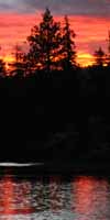
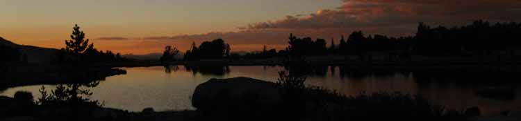
Yosemite Valley to Lyell Canyon
INDEX
Golden Triangle
TRAIL GUIDE INDEX
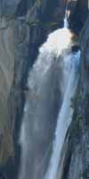
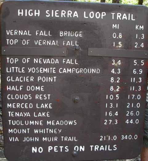
Happy Isles Trailhead
Part II
Alternative Route Back to the JMT-PCT INTRODUCTION The Way Back to the Crest
A Different Way
So, this next section of trail indexed below brings us from Yosemite Valley back up to the Sierra Crest. This section is the return and final leg of our Golden Triangle alternative route. That brings up some good questions.
Measure Me I have 25.94 miles from Yosemite Valley to the JMT in Lyell Canyon. That totals out to 47.74 miles without accounting for the distance from the TM Post Office out to the trail leading up to Vogelsang in Lyell Canyon, which would close the loop in Tuolumne Meadows.
Yosemite Signs
Zero Points That would make The Golden Triangle 54.8 miles in length from Tuolumne Meadows back to Tuolumne Meadows. This distance can be reduced by 5.6 miles if we measure the Golden Triangle from Yosemite Valley to where we resume the JMT in Lyell Canyon. Thus the Golden Triangle adds in the neighborhood of 49.2 miles to the length of our Tahoe to Whitney backpacking trip, and likely around 4000 extra feet of climbing.
Unique
Trail Guide Index Golden Triangle II Yosemite Valley to Reds Meadow via Merced Lake and Vogelsang HSC
Happy Isle Trailhead
Post up your experiences, information, and your questions and comments about backpacking into and out of Yosemite Valley. |
Tuolumne Meadows to Yosemite Valley |
Trail Guide Pages
|
7.5 minute Maps |
30 minute Maps
|
| N Lake's |
North: South:
Yosemite Valley |
Backpacking Yosemite Valley H THIS PAGE IS UNDER CONSTRUCTION: STAY TUNED FOR MUCH MORE! COME ON BACK NOW, 'YA HEAR?
7.5 Map: 30 min Map |
Backpacking Trail Guide PCT North Yosemite Valley |
 |
Backpacking Trail Guide PCT South |
Backpacker Forums Have a great trip or story to relate about Yosemite or in the Sierra Nevada? Post it on Above we come to the Front Page of the High Backpacking Trails and Topics Forums. Below we break the forums down into categories:
The Trails Forum acts as your place to put up input, comments, relate your experiences, or ask questions about each segment and spot along the length of our combined TYT-PCT-JMT trails. The Forum is your place to supplement the trail guide. Anyone can post text comments in the existing forums, but only members can post up new topics, along with images, maps, and formatting. If you have experiences, comments, questions, or pictures and videos of the John Muir Trail between Yosemite Valley and Lyell Canyon, post up here as an unknown hiker or as a member: Forum Section
|
Trailhead
Contact
Alex Wierbinski

Backpacking Lake Tahoe to Mount Whitney
Your Guide to the High Sierra Crest, including the Tahoe to Yosemite, Pacific Crest, and John Muir Trails
