The Trails
Guide
Maps
Miles/Ele
Permits
Resupply
Forum
Current Weather Conditions
Weather Notes
Northern High Sierras
Central High Sierras
Southern High Sierras
Gear
Gear List
Gettin Started
Layering
Discussion
Testing yourself and your gear
Gear Reviews
Backpacking
Clarks Fork Lower Ford through Saint Marys Pass to Highway 108
Hiking
The Tahoe to Yosemite Trail from Lake Alpine to Saint Marys Pass Trailhead
Languages
Languages
Trail Arts
The art of walking
Physical Preperation
Trail Skills
The trail
Off the trail
Scrambling
Maps
Navigation
Camp skills
Food
Resupply
Food
Other
Photo Catagories
Trail Stories
Trail Culture
News and Science
Links
Groups
Books
Terms and Conditions of Use
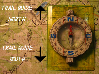
| Trail Guide Index Highway 4 to Highway 108 |
North TYT to Boulder Creek |
South |
TYT Topo Map Clarks Fork Headwaters- Saint Marys Pass TH |
30 min TYT Map Lake Alpine to Saint Marys Pass |
TYT Lake Alpine to Saint Marys Pass MILES AND ELEVATIONS |
ALL TYT TOPO MAPS Lake Alpine to Saint Marys Pass |
Resupply North Lake Alpine Resupply South Kennedy Meadows Pack Station |
National Forest Stanislaus |
Weather | all maps index |
| East to PCT Boulder Lake |
TYT-PCT Map REGION MAP Sonora Pass Region Map |
Through
The Clarks Fork Headwaters Bowl
to the
Saint Marys Pass Trailhead
A Difficult Segment of Unmaintained and Untrailed Route Finding
The Lower Ford of the Clarks Fork of the Stanislaus River The Lower Ford of the Clarks Fork of the Stanislaus River Backpacker
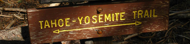
The Tahoe to Yosemite Trail through the Carson-Iceberg Wilderness. |
|||||||||||||||||||||||||||||||||
Information TYT MAP CARSON-ICEBERG MAP BOULDER LAKE TO PCT MAP
The above are our Trail Options from Boulder Creek
|
|||||||||||
We Have Many route Options
from
Clarks Fork Lower Ford
Backpacking Trail Guide North |
|
East |
Backpacking Trail Guide South |
TYT Hiker The Tahoe to Yosemite Trail hiker has a range of significant hiking alternatives other than hiking this last very difficult unmaintained segment of the Tahoe to Yosemite Trail along the the upper reaches of the Clarks Fork of the Stanislaus to Saint Marys Pass, which is depicted below. In any case, you don't have to hike this difficult section of unmaintained trail. Southbound Tahoe to Yosemite Trail hikers enter the valley of the Clarks Fork of the Stanislaus River where we hike over Jenkins Canyon into Arnot Creek and through its trailhead onto the Clarks Fork Road. Carson Iceberg Backpacking Options off the TYT Our second option was to hike up Arnot Creek to the PCT where we dropped down to Arnot Creek through Woods Gulch. Our next option off the TYT to the PCT will be through the Disaster Creek Trailhead at the end of the paved Clarks Fork Road. This Boulder Lake trail junction is our last trail up to the PCT from the TYT. I consider the "standard" route of the TYT only one of many alternative routes we can hike across or around the Carson Iceberg Wilderness. I say hike them all. Trail Recommendation
Second Option We hit it and split it... Options The Pacific Crest Trail intersects with Highway 108 through Sonora Pass a mile East of where the Southbound Tahoe to Yosemite hikes through Saint Marys Pass Trailhead onto Highway 108. Let's Do This Thing
|
|
Our arrival at the lowest ford of the Clarks Fork of the Stanislaus River is marked by easy to see ducks on the South bank of the river. Note that the power of the Spring thaw may remove existing ducks. |
 |
||||
Duck on the South shore of the lowest ford of the three fords across the unmaintained segment of the TYT through the upper Clarks Fork.
|
Segment IV Lowest Ford to the Northwest Edge of Clarks Fork Meadow Images and Guide Film route distance 8370 to 8800 feet video duration
|
 |
||
Duck on the South side of the lowest ford. South of here the trail melts into little more than a route through the terrain. North of here the trail expands, its various pieces connect up with increasing regularity, and we can begin to Dream of soon seeing maintained trails.
|
Last-First Blaze A few hundred yards South of the lower ford hiking through dense forest we encounter a dried out trench of a Spring flowing tributary surrounded by blazed trees. I note this location as the last blaze (or blazes) Southbound hikers will encounter along this section of trail, or the first that Northbound hikers will encounter. South of this point the trail fades significantly, disappears more than it appears, and begin approaching the bottom of the very stiff climb up a jumbled mountainside leading up to the North edge of Clarks Fork Meadow. Difficulty increases dramatically South of this position. North of here the trail widens, deepens, and we experience decreasing obstacles. South of here it disappears. |
 |
||
Is this our First blaze below Clarks Meadow?
|
 |
Yes! Detail of our first-or last blaze, depending on our direction. First blaze below Clarks Meadow. The trail gets considerably easier and real unmaintained trails begin North of here while the trail deteriorates South of this point into a route. |
Gateway Ducks These two duck sit at the bottom of the steep climb up to the edge of Clarks Fork Meadow. Note how the ducks were placed on two boulders that the trail route threads through. Thus the term "gateway" ducks... I like that. A fitting marker for the difficulty of the upcoming route South. Though I made the gateway ducks marking the East Carson River Trail along the Pacific Crest Trail I did not construct this gateway, but I totally approve! It is really hard for even the dullest hiker to miss gateway ducks... From this point South the trail route becomes dependant upon our route-finding skills. If we have skills of observation, analysis, and good decision-making skills we will maintain the old route and occasionally encounter the relief of hiking on trail bed. If we do not have route finding skills we will wander off the proper route which will make us work considerably harder and lengthen the time it will take to make our way up to Clarks Fork Meadow.
|
 |
||||
Ducks at the base of the steep climb up to Clarks Fork Meadow. Here the steep climb South up to Clarks Fork Meadow begins in earnest.
Unmaintained TYT Trail Reports
|
Space Ducks-Rough Terrain-Shards of unmaintained trail route I did not take a lot of pictures of this section as I was fully employed by the tasks of working like a dog, constantly scanning and studying the terrain to find a duck or point of terrain logic that would guide me to my next position, or working my way through on my best guess about the progression of the route through the terrain to my next position of observation and analysis. I took the image below after locating this duck as I pondered my next move. Then I put the frkn camera away and made it. |
 |
||
Look! A duck! Let's go that way! Duck below Clarks Meadow.
|
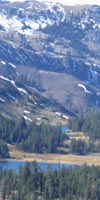
Scenes at the end of Clarks Fork Meadow We cannot mistake our arriving or departing the North edge of the Clarks Fork Meadow. Here the trail transitions radically through this narrow pinching of the neck of the canyon that marks the Northwest limit of Clarks Fork Meadow. Climbing Southbound up out of our struggle up the short section of steep rocky mountainside below the meadow presents us with an inviting scene: a beautiful green meadow flat sits behind a beautiful rock channel containing a mini-waterfall flowing into a beautiful mini-pool which flows through a mini-granite "pocket" gorge, all surrounded by inviting shady forests of lodgepole pine. A fine ancient campsite sits under the edge of the forest to our Left, across the ford. I'll bet the Natives kicked it here for a thousand years of Summers, then the Westerners afterward, and now us. The scene in the mini-gorge at our feet is reminiscent of the granite formations at Carson Falls along the East Carson River, but in a miniaturized form. It is kind of like a scale-model, except that it is real. The Middle Ford This North edge of the Clarks Fork Meadow also locates the middle ford of our journey up the Clarks Fork. A few steps above the mini-fall a series of granite rock stepping-stones makes this an easy ford during low water flows. Though the lower ford's location does not set off mental alarms, this middle ford does. The lower ford is in a location that would allow the river to widen rather than deepen during high water flows while this middle ford sparks my unease: This ford would be downright dangerous during high water flows. Its narrow granite channel would deepen dangerously and focus this deeper flow into a powerful current that could easily sweep backpackers over the mini-waterfall below, which would be generating terrifying power during high water flows of the Spring Thaw. Not a pretty picture. This middle ford at the North end of the Clarks Fork Meadow should be a serious consideration and concern for hikers planning a trip through here during times of potential high water flows. Possibly hikers could ford further to the South where the river's flow could potentially spread out across the meadow sufficiently to lessen fording dangers. Maybe not. Remember, of all the things that can kill you in the Sierra Nevada fording and lightening are the most successful at dealing death to backpackers. Don't make stupid decisions. Always carry sufficient food and preserve sufficient energy to turn around and/or reroute when facing obstacles of death. Overall Impression We veer Left of the North edge of the meadow to find the route down the mountain if we are hiking North. To the South behind the granite waterfall we see the inviting green of the almost-flatness of Clarks Fork Meadow bending away to our Left, Southeast, moving gently upward to eventually put itself under the sheer upper sections of the headwaters bowl we must climb through to make our escape from the Clarks Fork of the Stanislaus River. We will find segments of this shrinking meadow running Southeast like pearls along the string-line of the narrowing Clarks Fork River. The Clarks Fork Meadow has already been segmented by forest intrusions, squeezed down into a series of small bright green shelves of glowing meadow separated and surrounded by the deep shadows of the encroaching lodgepole forest. Our best route South pushes up into the forest around the North edge of this series of meadows. It appears that this meadow was much larger in the past, before expanding tendrils of forest broke it into smaller segments and subsequently began shrinking each segment down within a closing circle of trees. My impression is of a series of small almost-flat meadows descending like a series of green steps, separated by forest, down from the upper canyon under the headwaters bowl. It appears that they don't run cows up here to graze anymore, which is allowing these meadows to fill in. I'd say the route up has deteriorated enough to keep the grazing stock out. Each step down to a lower, or up to an higher meadow section is separated and surrounded by dense lodgepole forest making this a hike through alternating sections of dark shadows and vibrant light. South of the North edge of the Clarks Fork Meadow all trail bed disappears. Note that the trail route as defined on this 1979 USGS topo map ends at the Northwest edge of the Clarks Fork Meadow. Between this point South to where we jump on the trail coming up from Saint Marys Pass we are on relying on our own route finding skills and a few "wild ducks." A deep feeling of isolation is imparted by this short segment of our hike by the combined factors of natural quiet, the lack of trails, and resulting lack of people and signs of human. It's a nice feeling. |
Sweet View
North-Northwest
of
Upper Clarks Fork Canyon below
North Lip
of
Clarks Fork Meadow
 |
||||
The approaching sunset's horizontal lighting brightens up the canyon wall below Clarks Fork Meadow along the Tahoe to Yosemite Trail route. Our Southbound route came up here via the steep flank to our Left, out of view of this image.
Unmaintained TYT Trail Reports
|
Very Cool Rock Channel
 |
Waterfall at the ford at the end of Clarks Meadow. At the North end of Clarks Fork Meadow the river, now flowing at the volume of a creek way up here, flows through a hard rock channel before tumbling down the canyon below. This rock channel starts with a nice little waterfall, pools up below, then flows through the bottom of a "mini-gorge" before flowing off the North edge of the meadow. In the image above we can see the rocks we used as stepping stones where we crossed over from the Northwest to the Southeast side of the Clarks Fork. We ford where we enter the North edge of the Clarks Fork Meadow. Below we see the view when we turn around and look off the North edge of the meadow. |
 |
||
Sunset colors deepen view from Clarks Meadow in the Carson Iceberg Wilderness.
|
Segment V Clarks Fork Meadow Images and Guide Film route distance video duration
|
|
From the Northwest edge of Clarks Fork Meadow South to our climb out of the headwaters bowl we will be in the section of the USGS map designated as "Clarks Fork Meadow," though we will be hiking through dark forest as well as alongside bright meadow. I say "alongside bright meadow" as we are going to do our best to put as much distance between our route and the mosquito-filled green meadow. The route South is situated on the North side of the meadow as close to the surrounding canyon wall as practical, to provide the greatest distance from the moisture, mosquitoes, and quagmire nature of the meadow as possible. Though the map depicts a great open meadow through this section my observations indicate the meadow is much smaller than indicated on the maps and is broken into meadow segments by intervening forest intrusions. About a half-mile South of the North end of Clarks Fork Meadow brings us to the upper and final ford of the Clarks Fork. Here we will find ducks and a carved tree that indicate the location we cross over to the South bank of the Clarks Fork. Our exit out of the South end of the Clarks Fork Meadow follows a small creek about 200 yards South of the upper ford that flows into the Clarks Fork down from the South rim of the headwaters bowl. We'll ford, then proceed cautiously upstream until we find the creek feeding into the Clarks Fork from the South. A little scouting will show us if this is the channel in the surrounding cliffs that we can follow up to the top of the headwaters bowl. There's an old wild duck at the base of the route up the cliff, but we can't depend on it being there.
|
 |
||||
View North from the Northwest end of Clarks Fork Meadow. There are lots of nice places to sit in the granite features, drink a hot chocolate, watch the evening shadows lengthen while listening to the melody of the river tumbling through its rocky channel with the breeze blowing through the trees. The deep peace that ensues after such hard work validates all aspects of the experience.
|
View North of the end of Clarks Fork Meadow Hiking South from the North end of Clarks Meadow we hike over a couple of the ridge arms descending off the North wall of the canyon under Stanislaus Peak. We get up and out of the meadow. We'll see a faint animal/backpacker route up around the North edge of the meadow. Below we've turned around to look Northwest back down at the route we've taken hiking South from the North end of the Clarks Fork Meadow. You can see we've climbed around the North edge of the meadow. The gap in the mountains signifying the end of this section of forest and meadow, the North end of Clarks Fork Meadow, is between the pinching V of the gap we can see across the top of the forest in the middle distant center of the image. I had chosen a high route around a bend in the meadow and was rewarded with the reassurance of a few "wild ducks" and a good route showing that other hikers had also chosen this route through the terrain. Keep our eyes open and we will see a rough line of wild ducks bringing us high up to skirt around the North edge of the extent of Clarks Fork Meadow. |
 |
||
Duck pointing way North overlooking the tapering end of the Clarks Fork Meadow segment of our route below. Unmaintained TYT Trail Reports
|
| Bright Meadow and Dark Forest Shadow |
 |
Dropping back down to River/Meadow level North of the upper ford finds us skirting along the edge of the meadow. Narrowing segments of meadow with pressing forest along length of meadow segments. |
| Great Granite Walls rise on both Sides |
 |
||
Granite wall on the South flank of the headwaters bowl approaching the very upper reaches of the Clarks Fork, Tahoe to Yosemite Trail route.
|
| Bright Meadow, Dark Forest, and Sheer Rock |
 |
||
Looking Southwest across upper section of Clarks Fork Meadow. The canyon narrows and steepens above us entering the Clarks Fork headwaters bowl. We begin to feel a subtle pressure as the canyon narrows under steepening walls, a pressure of competition for space in the increased density of forest, which seems to increase the pressure of forest on the remaining meadow segments. This quiet, subtle pressure builds as the space disappears between the converging canyon walls, and this pressure leaks into our minds as an increasingly pressing need to understand where we are and find the easiest way out of here is at the forefront of our thoughts. Our navigation imperatives play out across terrain formed by the changing requirements of plant survival, across a battle between forest and meadow. Unmaintained TYT Trail Reports
|
| Old Bear Pie |
 |
Bear crap, old. No moisture. |
| Light and Shadow |
 |
||
The Sierra Nevada Mountains is a study in contrasts. Transition zone between Dark Forest along bright upper reaches of Clarks Meadow.
|
| The Upper Ford |
 |
||||
Blaze at the upper ford. Facing Southeast. A great boulder alongside the Clarks Fork with a rock on it shows us the location of the ford before we see the carving on the tree above. Southbound hikers must pass the tree, and turn around, to see the blaze above.
Unmaintained TYT Trail Reports
|
Great Boulders at the Upper Ford
 |
Duck at the top ford of the Clarks Fork fork of the Stanislaus River. These great boulder appear to have tumbled off the surrounding cliffs. |
Segment VI Headwaters Passage Images and Guide Film route distance 9040 to 10400 feet of elevation video duration
|
|
Likely a Satyr Anglewing, if my identification is correct. |
 |
||
Butterfly upper Clarks Fork of the Stanislaus River.
|
The Clarks Fork of the Stanislaus River Flowing as a tranquil creek below the headwaters bowl. |
 |
||||
Creek flowing out of the Headwaters Bowl of the Clarks Fork of the Stanislaus River. We're looking almost directly East up the last bit of the Clarks Fork in its headwaters bowl. Here we find the channel up through the surrounding cliffs off to our Right, to the South.
Unmaintained TYT Trail Reports
|
The Last or First Wild Duck At the base of the Southern Passage cutting its steep route South through the rock channel up to the rim of the headwaters bowl we find this big wild duck. Though leading to no particular trail this duck marks the position of the granite channel above and the beginning of the hike North through Clarks Fork Meadow below. |
 |
||
Wild Duck This is the top and last duck for Southbound hikers below the rocky channel climbing out of the base of the Clarks Fork of the Stanislaus River to the top of its headwaters bowl. Northbound hikers will find this duck is the first is a series of wild ducks leading down to the North end of Clarks Fork Meadow.
|
Channel into and out of the Clarks Fork Headwaters Bowl The rocky cliffs are descending to the Right (West) of the channel out of the Headwaters Bowl. |
 |
||
Terrain making up the South wall of the headwaters bowl near the rocky channel we will climb up to the top of the headwaters bowl.
|
South Wall of the Clarks Fork Headwaters Bowl
 |
||
Majestic rock lining the South side of the Clarks Fork headwaters bowl. This view to the Southeast is from the lower reaches of the rocky channel up to the top.
|
View East at the top of the River and the Eastern Extent of the Headwaters Bowl Climbing between the top and the bottom of the headwaters bowl we get a couple of views East at the womb of the Clarks Fork of the Stanislaus River. The low point in the distance is Saint Marys Pass. |
 |
||
Rough country along the South flank of the headwaters bowl of the Clarks Fork of the Stanislaus River looking Eastward. Unmaintained TYT Trail Reports
|
Inviting Forest at the base of the Rock Channel Looking down at the base of the Clarks Fork headwaters bowl. This is a happy sight for Northbound hikers, indicating that our route does indeed bring us down to the Clarks Fork hidden in the forest below. |
 |
||||
Upper section of the Clarks Fork of the Stanislaus from the hiking route from the bottom to the top of the Headwaters bowl.
|
View Northeast at very upper reaches of Headwaters Bowl While climbing North-South between the base and top of the headwaters bowl we are able to observe the details of the upper reaches of the Clarks Fork of the Stanislaus to our East. We can see that the headwaters bowl is shaped like a narrow horseshoe. |
 |
Looking East up at the Headwaters Bowl of the Clarks Fork of the Stanislaus River from half-way between the top and bottom. |
Coming through the Rocky Channel An adventure is composed of not knowing exactly what is going to happen next... and this section of the trail provides just that experience. Up we go! |
 |
||
Rocky channel between the top of the headwaters bowl and Clarks Fork of the Stanislaus at the bottom.
|
Coming through the Rocky Channel Wall to Northeast as we climb up to our Right, Southeast. |
 |
||||
Sweet granite cliffs along route between Clarks Fork River and the top of the headwaters bowl. This is an amazing little piece of our route. A creek runs down from the top of the headwaters bowl through this channel in the cliffs to the Clarks Fork at their base. Along the way are a series of sweet spots. There were a couple of nice places one could camp here, up near the top and at the top.
Unmaintained TYT Trail Reports
|
Looking through the Top of the Rocky Channel at the top of the Headwaters Bowl Sweet relief: We will turn Left, East as the channel recedes and the terrain opens up onto the broad flat wrapping around the top of the cliffs making up the Clarks Fork headwaters bowl. |
 |
||
The final bit of our route between top of headwaters bowl and the River below.
|
Segment VII Cross-Country Images and Guide Film route distance No overall elevation change video duration
|
Exploring the Potential ways down to the Clarks Fork Working my way East around the South side of the upper rim of the Headwaters I explored this channel before rejecting it as a route down. I'd need wings for this one. I took this shot after climbing back out of my exploratory probe down mountain.
|
 |
||
The wrong way down to the Clarks Fork! This is a bit East of the route down.
|
View from the Top Stanislaus Peak tops the Northern ridgeline above the Clarks Fork viewed looking West from the rim at the top of the Headwaters Bowl of the Clarks Fork of the Stanislaus River. |
 |
||||
Stanislaus Peak from the Headwaters of the Clarks Fork of the Stanislaus River.
|
Long View of the Stanislaus Drainage Twisting path of Clarks Fork through the Western Flank of the Sierra Nevada Mountains from the top of the Headwaters Bowl. |
 |
| View West down the valley of the Clarks Fork of the Stanislaus River. |
Segment VIII Saint Marys Pass Trail and Trailhead Images and Guide Film By route I mean that when the trail up from the Saint Marys Pass Trailhead brings us above the elevation of the granite formation blocking the SE approach to Saint Marys Pass, and the trail draws near and above the creek, I begin looking West for a good cross-country route through Saint Marys Pass into the headwaters bowl of the Clarks Fork. route distance 10400 to 9440 feet video duration
|
 |
||||
Carson Iceberg Wilderness Boundary around Clarks Fork Headwaters.
Unmaintained TYT Trail Reports
|
Saint Marys Pass Saint Marys Pass is the low point making up the saddle in the ridge on the Right side of the image, to the Right of the pointy feature above upper section of the granite feature. My plan is to use the Saint Marys Pass Trail to put myself above the granite so I have a clear traverse from the trail to Saint Marys Pass. |
 |
||
Saint Marys Pass from the East side.
|
 |
||
Camelback formation sitting at the base of the Southwest corner of Sonora Peak.
|
 |
| Flowers. |
|
I spotted a fast moving hiker coming down the trail. |
 |
||
Gerry is a local day hiker dedicated to seeing the Sierra.
|
|
Descending to the Saint Marys Pass Trailhead at the bottom of our trail along the Western edge of the meadow feeding Deadman Creek situated between Leavitt and Sonora Peaks is visible with Highway 108 winding its way along its edge. |
 |
||||
Westbound Highway 108 turning into the Big V. This is the bottom of the meadow off the West flank from Sonora Pass where Deadman Creek begins its flow down to the Middle Fork of the Stanislaus River through Kennedy Meadows Pack Station. Our Saint Marys Pass Trailhead is located along the North edge of this meadow about a mile West of Sonora Pass.
|
|
We get great views of the Leavitt Massif to our South and note Leavitt Peak's position in the surrounding terrain. |
 |
||
Leavitt Massif to our South. Leavitt Peak is the peak to the Right down the ridgeline from the predominant peak, which is not Leavitt Peak but is Peak 10480. The peaks on the Left side of the image are all along the Pacific Crest Trail route over Leavitt Massif. That, my friends, is the Sierra Crestline South of Sonora Pass. The ridge descending to the Right of Leavitt Peak divides Deadman Creek's drainage on this side from Kennedy Creek's on its South side. Views of Leavitt Massif and Peak
|
 |
||
View South
|
Southwest edge of Sonora Peak
 |
||
View North Camelback lava formation on the Southwest side of Sonora Peak.
|
|
Dominating the scene to our Northeast. The Saint Marys Pass Trail runs up the Southwestern shoulder descending from Sonora Peak. |
 |
||||
Sonora Peak to the Northeast. The Pacific Crest Trail route almost reaches the rock formations on the Southwestern flank of Sonora Peak before turning down to Sonora Pass. We're at the point where the PCT and TYT come closest together before they join trails entering Yosemite. The map below Right shows where the trails swing close together off the Southwestern corner of Sonora Peak.
|
Local Color
 |
High Sierra grasshopper at 9500 feet. Living Things: |
Saint Marys Pass Trailhead The beginning, the end, or another way point on our endless trail. |
 |
||||
Saint Marys Pass Trailhead.
|
|
Northbound Hikers The nondescript sign marking the short dirt track up to the lonely Saint Marys Pass trailhead is easy to miss. The Saint Marys Pass trailhead itself is situated a short distance up a dirt road one mile West of Sonora Pass on the North side of Highway 108 above the great meadow. Our route, if hiking North through Saint Marys Pass, brings us and drops us into the top of the massive Western drainage off this whole section of the Western Sierra Crest into the top of the Clarks Fork of the Stanislaus River. Starting Backpacking Trips from Sonora or Saint Marys Passes The Eastbound Sonora Pass Road
begins bending a long arc to the Northeast tracing out the perimeter of this expansive high altitude meadow on our final approach to Sonora Pass. We will notice a rather exposed car-camping site sitting on the South side of Highway 108 just a few paces East of the Saint Marys Pass trailhead sign. Better car camping sites are located a short distance West, down the dirt roads located along the North side of Highway 108 a short ways down towards the bottom of the meadow. Map with Car Camping sites noted near Sonora Pass Use of Saint Marys Pass Trailhead In fact there are very few backpackers who hike this 11.25 mile section of mostly unmarked and unmaintained trail between the end of the Clarks Fork Road and the trailhead at Saint Marys Pass. The vast majority of use at the Saint Marys Pass trailhead is by dayhikers. The dayhikers are primarily attracted the access the trailhead offers to Stanislaus and Sonora Peaks. Backpackers along this section of the Tahoe to Yosemite Trail are discouraged by the steepness and difficulty of the unmaintained section of the TYT route between Saint Marys Pass and the Boulder Creek trail junction. Amenities at the Saint Marys Pass Trailhead Look West up the low rise at the left (South) side of the granite boulder up there for the sheltered little private site just West of the trailhead.
|
 |
||||||
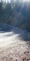
Saint Marys Pass road sign from Highway 108. Sign Missing as of July 2015, which makes the narrow dirt road difficult to locate... Kennedy Meadows is nine miles West down Highway 108, Sonora Pass a mile to our East.
Hiking South through the Saint Marys Pass Trailhead onto Highway 108 finishes the 34.57 mile long section of the Tahoe to Yosemite Trail from Lake Alpine to Saint Marys Pass. Good Work! South on the Tahoe to Yosemite Trail
|
North: Boulder Lake junction South: Sonora Pass Trailheads
Our progress down the |
||
Completed: Total Last Section Last Segment Forum Next Section COMPLETED: Next: Viva La Difference! At the top of this great Sierra canyon it feels like we are touching the sky hiking through the saddle of Brown Bear Pass looking at a big chunk of the Sierra Crestline across the high altitude heart of the Emigrant Wilderness. The route of the TYT is very unlike the route of the Pacific Crest Trail South of Sonora Pass. The PCT route follows the boundary defining the Eastern edge of the Emigrant Wilderness over Leavitt Massif before turning East down Kennedy Canyon towards the West West Walker River. The route of the PCT effectively brings the PCT hiker around the the next section of the Sierra Crest and the Emigrant Wilderness at the same time. Once over Leavitt Peak the PCT skirts around the high elevation Emigrant and Grizzly Meadows that are stashed between Big Sam and Bond Pass along the Sierra Crestline. The PCT route bends around the High Emigrant Basin, effectively missing the unique beauties stashed up there in the heart of the Emigrant Wilderness. Leavitt Massif is wonderful, and our TYT route through Kennedy Meadows misses it, but Leavitt Peak does not represent the range of beauties in Emigrant Wilderness. It is a higher route than the TYT South out of Kennedy Meadows, but lacks the complexity we find hiking the granite-volcanic interface up Summit Creek up from Kennedy Meadows, or the sub-alpine eden of the Emigrant and Grizzly Meadows. This is divine terrain. The stupid routing of the PCT around Emigrant Wilderness is good for me, and other hikers who enjoy the quiet preserved by routing the PCT around this unique place. My appreciation goes out to whoever was responsible for routing the PCT around Emigrant Wilderness. The section of this map below depicting the South side of Highway 108 shows all of our PCT & TYT options South to Yosemite. Sonora Pass Region Map Northbound PCT Alternative Routes Bond Pass to Brown Bear Pass The easiest way, but not the most scenic, is for Northbound PCT hikers to continue hiking West from the trail junction at the top of Kennedy Canyon on the South side of Leavitt Peak, rather than South over Leavitt Peak to Highway 108. This is a quick and easy route into Kennedy Meadows Pack Station. Kennedy Canyon to Kennedy Creek and Lake The first route option above, from Bond to Brown Bear Passes, brings us through some of the most stunningly beautiful sections of the Emigrant Wilderness, rather than around them... The second option is not as scenic, but is the most effective/efficient way to hike directly into Kennedy Meadows off the Northbound PCT. The And so too here at Saint Marys Pass Trailhead we are at a high point along the Tahoe to Yosemite Trail about to head down to a deep low point. Specifically, I believe that the TYT route South from Kennedy Meadows is more scenic, longer, and does more climbing through more diverse levels of Sierra beauty to the North Yosemite Backcountry than the PCT South from Sonora Pass. In general, the Tahoe to Yosemite Trail veers much further away from the Sierra Crestline and dives deeper in elevation down the Western flank of the Sierra between returns to the crest than the Pacific Crest Trail as they follow their very divergent, but yet roughly parallel routes down the length of the North Sierra. The PCT South of the Tahoe Basin has remained predominately on the East flank of the Sierra just below or along the crestline, with a couple of notable exceptions. The TYT stays on the Western flank, without exception. Which route appeals to you more depends on your particular definition of fun. I like 'em both, and long ago began to mix and match up various sections of each to make my own custom long distance backpacking routes from Tahoe to Yosemite and on down to Whitney. My goal here is to open this can of worms up a bit for you, get you to peek inside, then watch you rip the lid off yourself. Our next drop in elevation hiking the Tahoe to Yosemite Trail brings us down to and through Kennedy Meadows Pack Station. Our next section of the TYT from Kennedy Meadows to Bond Pass in Yosemite is also the last real difference between the PCT and TYT. Southbound TYT Trailhead on Highway 108 Where is it? Catch a Ride As I mentioned above, Dee was driving up the twisting upper sections of Highway 108 like Mario Andretti. I was not worried, as Dee was downshifting and braking properly as she entered cork-screwing corners, and pulling good acceleration out. Old Dee knew how to drive mountain roads. Lots of folks don't have that skill. Trails Rejoined I generally decide between the Wilmer or Tilden trail option based on the time of year. Early in Spring I choose the Tilden Lake Loop, as the terrain around Tilden dries out more quickly than the lower elevation Wilmer Lake, which will be living under a thicker cloud of mosquitoes early in the season. And later in the season as well, as Wilmer seems to be sitting atop a big granite bowl which holds great amounts of moisture late into the Summer Season, feeding and keeping Spring Mosquito conditions alive long after the heat of Summer dries out the surrounding terrain. Heck, Tilden gets a better breeze all Summer long, which blows the mosquitoes away. Tilden is also the route less traveled, which makes it quieter than the PCT around Wilmer Lake. Other than mosquito considerations, if I was you I would choose to hike the route I had not yet hiked. Do one. Do the other. Mix your favorite sections, and expand the length of your trips, skills, fitness, and knowledge simultaneously into greater challenges and rewards.
7.5 topo hiking Map 7.5 topo hiking Map 30 min topo hiking Map
Next page South |
| Where Do We Go From Sonora-Saint Marys Passes? Below are our options North and South on the TYT and PCT |
||||
Backpacking North
|
Backpacking South Kennedy Meadows |
Backpacking East
|
Backpacking South |
Backpacking North |
| Note *The guide page above covers the Southbound TYT from Boulder Lake trail junction to Saint Marys Pass. |
||||
Backpacker ForumsHave a great Sierra Nevada trip or story to relate? A fine piece of gear? Or gear that failed?Post it on
|
North: Jenkins Canyon to Boulder Lake junction South: Sonora Pass Trailheads
Trailhead
Contact
Alex Wierbinski

Backpacking Lake Tahoe to Mount Whitney
Your Guide to the High Sierra Crest, including the Tahoe to Yosemite, Pacific Crest, and John Muir Trails
