


Featuring The
Tahoe to Yosemite Trail
Kennedy Lake Trail Junction
to the
Pacific Crest Trail at the Top of Kennedy Canyon
Backpacking
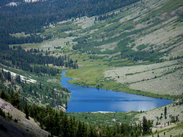
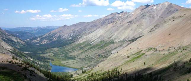
Kennedy Lake in the Emigrant Wilderness
Linking the Tahoe to Yosemite Trail and Pacific Crest Trails
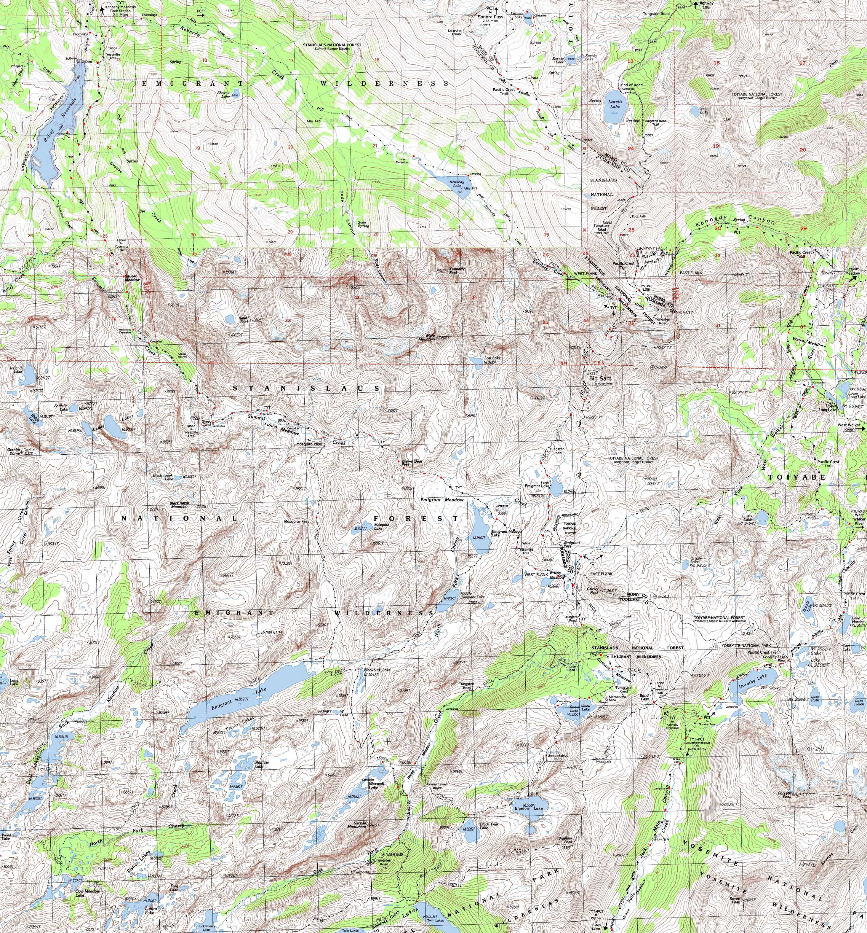
Four USGS 7.5 minute Backpacking Topo Maps of the Emigrant Wilderness

Maps |
Map |
Map |
Trail |
TYT |
PCT |
Trail Guide |
REGION |
Click |
All maps |
|
Permits, Map Information |
Connecting
Tahoe to Yosemite Trail to the Pacific Crest Trail through Kennedy Lake in the Emigrant Wilderness
MAGNIFY THIS MAP!
| Northwest TYT Kennedy Meadows to Relief Reservoir |
North PCT Sonora Pass to Kennedy Canyon trail junction |
Click |
East Flank PCT S across Dorothy Lake Pass into Yosemite or NE to Leavitt Meadow |
South PCT & TYT Yosemite! Jack Main Canyon to Tilden Lake Loop and Wilmer Lake |
The Tahoe to Yosemite
and
Pacific Crest Trails
across
Emigrant Wilderness
|
| Northwest TYT TYT Kennedy Meadows to Relief Reservoir |
North PCT Sonora Pass to Kennedy Canyon trail junction |
Click Red Dots |
East Flank PCT S across Dorothy Lake Pass into Yosemite or NE to Leavitt Meadow |
South PCT & TYT Yosemite! Jack Main Canyon to Tilden Lake Loop and Wilmer Lake |
Hiking Map |
||||
Main Backpacking Features Hiking East from the Tahoe to Yosemite Trail up the Western Sierra Flank to Kennedy Lake South of Kennedy Meadows Pack Station opens up much more that a short spur trail to a beautiful lake between the Tahoe to Yosemite and Pacific Crest Trails. Compare the images of Kennedy Lake below with the map above.
Above Kennedy Lake the fine trail slowly degrades into a faint unmaintained track fairly easy and fun to follow up to where the Pacific Crest Trail turns East off a low gap along the Sierra Crestline between the East and West Flanks of the Sierra Nevada Mountains. At the start of Kennedy Meadows the Summit Creek officially takes a promotion in status, flowing past Kennedy Meadows Pack Station as the North Fork of the Stanislaus River. Meanwhile, back on the Sierra Crestline above Kennedy Lake we find great peaks to our North and South with valleys descending East and West. Here on this low spot on the Sierra Crestline we find trails to the cardinal compass points. The Kennedy Canyon trail junction was broken during 2012.
At this broken trail junction (the post was broken and prostrate on the trail as of July 2012) we have excellent hiking options in all directions. Oh yeah. We're Here. Where?
Here. Need to See it Again? To the North the PCT crosses over Leavitt Peak towards Sonora Pass. To the South the old track of the Tungsten Road crosses Big Sam to intersect with the Tahoe to Yosemite Trail at the foot of Grizzly Peak. To the East the Southbound PCT route drops down Kennedy Canyon before bending South to climb into the Yosemite backcountry through Dorothy Lake Pass. Map Problems Solved above TYT Trail South from lower footbridge on Summit Creek TYT Trail route to Kennedy Lake trail junction Unmaintained route above Kennedy Lake PCT route down Kennedy Canyon
Mapology What's important for our general reference purpose is that each side of a square is 1000 meters, or a Kilometer. From my point of view that is 1093.6 yards or .62 of a mile. Diagonal: 1414.22 meters, if my trig is correct. That converts into 4,639.8 feet or .88 of a mile.
top of page |

| Road Tripping | Permits, Mapping, Mileage, and National Forest Information | |
Pick a trailhead on one highway and hike to a trailhead on the next highway. Between the first highway and the next highway switch over from the Pacific Crest to the Tahoe to Yosemite Trail to expand your view. Standing at the trail junction between Kennedy Canyon and Kennedy Lake's Valleys puts us 7.97 miles South of Sonora Pass at the highpoint of Highway 108 crossing the Sierra Crest.
Working: Google Road Map Collection of Road Maps supplementing the Tahoe to Whitney trail guide.
|
Miles and Elevations South from Kennedy Meadows Pack Station Kennedy Meadows Pack Station Gate to Kennedy Lake trail junction: 2.67 miles. Kennedy Lake trail junction to Kennedy Lake: 4.39 miles. Kennedy Lake junction on TYT to PCT at Kennedy Canyon trail junction: 8.39 miles. Tahoe to Yosemite Trail at the Kennedy Meadows Gate to Kennedy Canyon PCT Trail Junction is 11.06 miles. South from Highway 108 Sonora Pass to Kennedy Canyon trail junction: 7.97 miles. Kennedy Meadows Pack Station to Sonora Pass via Kennedy Lake is 19.03 miles. Let's expand the circle by a notch: South into Emigrant Basin. Kennedy Canyon trail junction to Tahoe to Yosemite Trail at Grizzly Peak: 6.17 miles. Grizzly Peak North to Kennedy Meadows along Tahoe to Yosemite Trail: 13.83 miles. Emigrant Wilderness Backpacking Loop Kennedy Meadows Pack Station loop via Kennedy Lake to Grizzly Peak to TYT North to Kennedy Meadows: 31.06 miles. |
Four USGS Northwest Map Northeast Map Southwest Map Name Southeast Map Name Compass Offset Standard |
| Backpacking Permit Authorities | ||
West Side and Sonora Pass
Stanislaus National Forest Wilderness TahoetoWhitney Contacts: Stanislaus National Forest National Forest Wilderness Area information: Emigrant WildernessRanger District: Summit Ranger District
|
East Side Leavitt Lake and West Walker through Leavitt Meadow
Toiyabe National Forest WildernessTahoetoWhitney Contacts: Toiyabe National Forest National Forest Wilderness Area information: Ranger District: Bridgeport Ranger District
|
|
| Above: Kennedy Lake below Leavitt Peak. The Beauties of backpacking Emigrant Wilderness. | ||
West Emigrant Topo Hiking Map: TYT Kennedy Meadows to Relief Reservoir Click RED DOTS North Emigrant Topo: PCT Sonora Pass South Topo Map Heart of Emigrant Wilderness: Big Sam to TYT Bond Pass East Side: PCT across Dorothy Lake Pass into Yosemite & Leavitt Meadow
Map Credit |
U.S. Geological Survey, Department of the Interior I love the USGS. Free Emigrant Wilderness Backpacking Maps Move the Map to the Sierras. Select size of Maps you wish to locate. Click "Mark Point" on map to see the USGS map grid of the selected map scale. USGS Topographic |