The Trails
Guide
Maps
Miles/Ele
Permits
Resupply
Forum
Current Weather Conditions
Weather Notes
Northern High Sierras
Central High Sierras
Southern High Sierras
Gear
Gear List
Gettin Started
Layering
Discussion
Testing yourself and your gear
Gear Reviews
Backpacking
to the
Big Meadow-Round Lake
Trail Junction
Hiking the Meiss Country Roadless Area
Languages
Languages
Trail Arts
The art of walking
Physical Preperation
Trail Skills
The trail
Off the trail
Scrambling
Maps
Navigation
Camp skills
Food
Resupply
Food
Other
Photo Catagories
Trail Stories
Trail Culture
News and Science
Links
Groups
Books
Terms and Conditions of Use
Southbound Unless we are fitting a local backpacking trip between the Big Meadow and South Upper Truckee Trailheads. In that case we would still proceed South to Round Lake, as Round Lake is a focus point of the local beauties here in this part of the Meiss Country Roadless Area. Our plan is to continue South straight through this Big Meadow junction to turn South at Meiss Cabin onto the combined routes of the TYT & PCT. We will follow the PCT-TYT South out of the South end of the Tahoe Basin to Carson Pass. We could turn North towards Echo Summit from Meiss Cabin. Or we could turn around and hike back to our starting trailhead, or even end our trip through the Big Meadow Trailhead. This part of the Meiss Country is a fantastic area for training trips to work out all our gear, food, fitness, and feelings issues. The hike from the South Upper Truckee Trailhead to this Big Meadow trail junction is quite difficult, though short. Perfect for training. Option Northbound Southbound Southbound Counter-Clockwise hikers on the Tahoe Rim Trail veer Left, bending closer to true South through this Big Meadow trail junction. The funny thing about this junction for TRT hikers is that hikers in either direction both end a descent to begin climbing away from the Big Meadow trail junction. This is a result of the unique configurations of trail and terrain. Finding
|
Tahoe to Whitney
&
Southbound backpackers
continue
South towards Round Lake
The South Upper Truckee Road Trailheadto theBig Meadow Trail JunctionUp from South Upper Truckee Trailhead We find the Big Meadow Trail Junction .23 of a mile South of the Dardanelles Lake Junction as we continue hiking South and up 2.81 of the 3.39 total miles to Round Lake from the South Upper Truckee Road. As I have mentioned previously, the trail re-routings between the South Upper Truckee Trailhead and the Burnt Flat have extended this figure a bit. I estimate that the route has been lengthened by up to .7 of a mile, maybe up to a total of 3.5 miles from trailhead to the Big Meadow trail junction. In & Out The Big Meadow Trailhead on Highway 89 is 2.68 miles to our Road Map of Big Meadow Trailhead Meiss Country Roadless Area Hiking Map
South .58 of a mile South up to Round Lake. North 2.81 miles North down to the
South Upper Truckee Trailhead
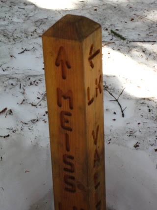
New trail junction post New trail posts were installed at the Dardanelles Lake and the
Trails Forum Comments-Questions-Experiences? Lake Valley and Meiss Lake The trail continuing South up to Round Lake and Meiss Cabin beyond this junction is labeled as "Meiss Lake." This is a bit misleading, as we first arrive at the Meiss Cabin trail junction in Meiss Meadow and must turn North from there before bending a U-turn off the trail North across an expanse of Meiss Meadow to reach Meiss Lake. Check out the map. There are videos and more images of the terrain climbing to Meiss Meadow on preceding and following trail guide pages. Labels pointing to maps North and South link to those maps, creating a chain of maps stretching from Lake Tahoe to Mount Whitney that are linked to each other, trail guide pages, and more detailed maps. Tahoe Rim Trail
Big Meadow Trail Junction Elevation Mileage 2.68 miles Northeast to the .58 of a mile South to 2.7 miles South to Road Map of Big Meadow Trailhead The colored dots on this map correlate with trail guide pages |
North: Dardanelles Lake Junction South: Meiss Country Roadless Area to Round Lake
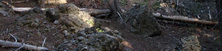
The Big Meadow Trail Junction |
|||||||||||||||||||||||
Hiking to the Big Meadow Trailhead
|
|||||||||||||||||||||||
| The Big Meadow Trailhead | ||
Scotts Lake
Excellent Side and Short Backpacking Trips
I have come up this route from the South Upper Truckee trail head through Big Meadow to Scotts Lake in mid-Winter. It is a wonderful little trip, though if you do it on a clear weekend you are almost certain to meet local cross-country skiers and snow travelers around Big Meadow.
Very nice folks. For a few years I was going up there a group of locals would come out and build a huge igloo on the Southwest corner of Big Meadow at the beginning of every Winter.
The Big Meadow route into Round Lake is a local's favorite Winter route.
During mid-week or during bad weather during Wintertime you likely will not encounter anyone at Scotts Lake.
Keep Track of Local Weather Conditions
Point Forecasts |
Regional NWS NWS |
| All High Sierra Weather Resources | |
Real Time |
|
All Ground Reporting Stations |
|
Road Conditions |
|
Big View |
Big View |
One Winter I cut my route straight up the mountain into Big Meadow from the South Upper Truckee Trailhead via the Burnt Flat, rather than following the East tributary of the South Upper Truckee River up to the snow-buried Big Meadow trail junction. No need to take the "long way" following the trail route in Winter when Winter itself reveals more direct routes.
Winter opens up many shortcuts through the mountains. After messing around and spending a night at Scotts Lake I backtracked out to exit at Big Meadow. I considered hiking down to Highway 88 in Hope Valley to hitch-hike back, but preferred to snow-shoe to the Big Meadow Trailhead.
This is very pretty terrain during Winter. The better we can withstand it, the more we can enjoy it. That's as true in Summer as Winter.
I have never hiked to Scotts Lake in Summer, but it is beautiful in Winter. This 30 minute map shows the Big Meadow Trailhead, Big Meadow, and Scotts Lake in proximity to our route up to Meiss Meadow via Round Lake, where we will hook up with the Southbound Tahoe to Yosemite and Pacific Crest Trail routes for the hike out of the Lake Tahoe Basin.
The triangular shape of the Meiss Country Roadless Area wedged in the Southern end of the Tahoe Basin does not lend itself to backpacking loop trips. In and out backpacking trips along the same route are nice, but repetitive.
The best hiking plan for the Meiss Country is for medium distance trailhead to trailhead trips across the length of the Meiss Country Roadless Area. You can't exceed medium distance backpacking trips in this small area unless you walk across it four of five times...
My favorite route through here is a Winter trip from South Upper Truckee Trailhead to Showers Lake via Round Lake, then out of the Tahoe Basin to Round Top Lake. From Round Top Lake we reenter the Tahoe Basin for the hike back down to the South Upper Truckee Trailhead via Round Lake. This trip is total joy. Well, it involves some hard work, bits of cold, and some route finding challenges, but those are the components of which joy is constructed.
Backpacking the beauty of the High Sierra offers much more that the sum total of its parts...
If you have a hiking partner and two cars drop off a car at the nearest trailhead then drive to the furthest trailhead, and hike back. For instance, drop a car off at Echo Summit on your way to the South Upper Truckee, Big Meadow, or Carson Pass trailheads. Then hike back to your stashed car across the Meiss Country Roadless Area.
As I hitch-hike in and out I worry more about the unknown amount of time it will take to get rides in and out, which is based on how much traffic is out there, than worrying about how to stash my car.
7.5 Topo Hiking Map
Meyers to Carson Pass
30 min Topo Hiking Map
Meiss Roadless Area
to
Carson Pass Management Area
Backpacking Trail Guide North |
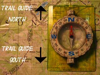 |
Backpacking Trail Guide South |
Backpacker ForumsGeneral Sierra Nevada hiking thoughts to relate?Post 'em on On the Forum you can browse trail locations and add your experiences, comments, questions (& pictures and videos if you Register...) about hiking South out of the Echo Summit Trail Head.General comments or specific information about the South Upper Truckee to Carson Gap section of the High Sierra trails, or this particular location are welcome: Section
|
North: Dardanelles Lake Junction South: Meiss Country Roadless Area to Round Lake
Trailhead
Contact
Alex Wierbinski

Backpacking Lake Tahoe to Mount Whitney
Your guide to the High Sierra Crest, including the Tahoe to Yosemite, Pacific Crest, and John Muir Trails
