


Backpacking Weather: Carson Pass Region Weather Map

| Sierra Weather | Carson Pass Weather | Northern Sierra Weather | Central Sierra Weather | Southern Sierra Weather | lake Tahoe Weather Map | Carson Pass Trail Map | Ebbetts Pass Map | Sonora Pass Map |
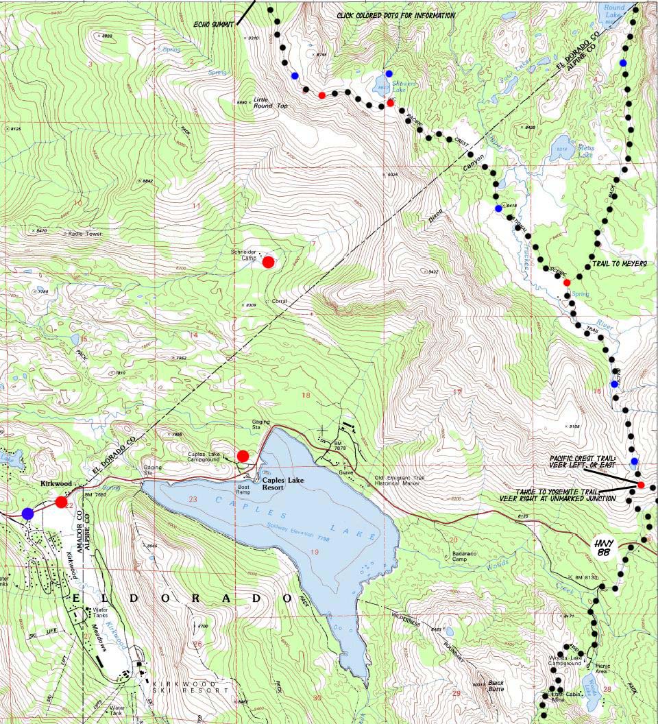
Click map dots for links to Weather Stations | trail guide index | maps index |
Highway 88, just a tad West of Carson Pass
The Pacific Crest-Tahoe to Yosemite trail is coming down from the North, from Echo Summit. The trail from Meyers Joins the Pacific Crest Trail after passing by Round Lake. The Pacific Crest Trail splits from the Tahoe to Yosemite Trail at an unmarked trail junction just past the Carson Gap above Highway 88.
Click the BIG Red AND Blue Points for weather stations. Click small red and blue points for Trail Guide Pages.Carson Pass Weather and Forecast Carson Pass Trail Map previous map: Desolation to Echo Summit Weather
|
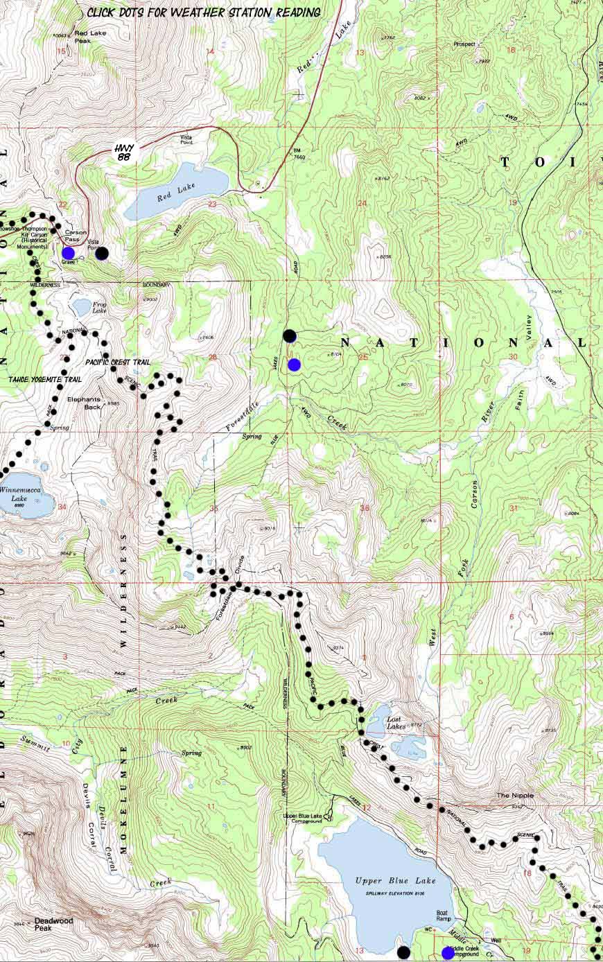
Below: If you follow the Pacific Crest Trail past Carson Pass heading South towards Blue Lakes, the Winnamuca Lake Junction is your Second Tahoe to Yosemite Trail cutoff.
|
note: The first Tahoe to Yosemite junction brings you to Woods Lake, where you follow the Lost Cabin Mine trail up to Round Top Lake. The Second Tahoe to Yosemite jucntion sits South of Carson Pass, and it brings you up to Round Top Lake past Lake Winnamuca.
| Basic Facts | Basic High Sierra Weather Resources for the Backpacker |
The Sierra Crest is noted for having the capacity to produce four seasons of weather during a single Summer Day. Rain, snow, hail, fog, lightening, and a bit of sunshine can all happen in quick sequence. The High Sierras are noted for rapid changes in weather and temperature, and the sudden appearance of harsh weather trends. You may experience anything from intense heat to bitterly cold Summer snow storms. Or you may not. In any case, weather must be considered and preparations made to deal with these weather facts BEFORE entering the High Sierras. Long Distance Backpackers who were on the High Sierra Crest in early August of 2009 experienced just such a series of Summer Snow Storms. Temperatures dropped to the high teens and low twenties, snow and hail fell which partially obscured the trails, and all of those who entertained the misconception that the Sierras only have fine weather during the Summertime were bitterly disappointed. Luckily for the many backcountry travelers who were not properly prepared, those storms blew apart, rather than consolidated and deepened. Weather considerations should guide your gear selection.
|
Weather Preparations for Backcountry TravelAll SeasonsAlways check the National Weather Service SatellitesThe NWS Satellites will give you an orbital view of potiential storm activity. Combined with your use of the NWS Maps and Forecasts, you can prepare yourself for the likely weather. Note: especially check the 28km infrared and water vapor animations, which require Java Script. Check the National Weather Service MapsNWS Maps Note: Especially Check the 24 to 48 Hour fronts and Precipitation Maps. Consult the National Weather Service Home PageThe National Weather Service Home Page displays large and small scale weather warnings which may pertain to your High Sierra backpacking plans. All Sierra Web Cams: Sierra Visions |
Map Credit |
U.S. Geological Survey, Department of the Interior: The USGS Use search term "Meeks Bay," and "Address," as search type to locate this USGS map. USGS Topographic Map Information |
Backpacker ForumsHave a great Sierra Nevada route or trip to relate?Post it: TahoetoWhitney.Org Experiences, comments, or pictures about this Section: Let it Rip HERE:Carson Pass Weather Forum |