The Trails
Guide
Maps
Miles/Ele
Permits
Resupply
Forum
Current Weather Conditions
Weather Notes
Northern High Sierras
Central High Sierras
Southern High Sierras
Gear
Gear List
Gettin Started
Layering
Discussion
Testing yourself and your gear
Gear Reviews
Dardanelles Lake
Trail Junction
Backpacking Up from the South Upper Truckee Road or Down from the Big Meadow Trailheads
Languages
Languages
Trail Arts
The art of walking
Physical Preperation
Trail Skills
The trail
Off the trail
Scrambling
Maps
Navigation
Camp skills
Food
Resupply
Food
Other
Photo Catagories
Trail Stories
Trail Culture
News and Science
Links
Groups
Books
Terms and Conditions of Use
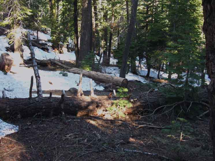
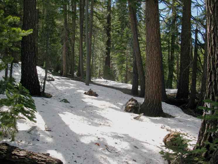
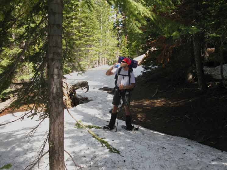
Trail Emerging from Spring Snow
 |
||||
Tracking the location of the trail by the cut timber sticking out of the rapidly melting Spring Snow of 2010. We are looking to the Southeast approaching the Dardanelles Lake trail junction.
Miles and Elevations
Our trail traversing the mountainside on the way up here is easier than the steep climb up to the Burnt Flat from the trailhead, but it is still a difficult climb. As all this climbing begins from the trailhead, take it easy. No need to burn ourselves out on the first day! Our trail here is still very "cozy," as the mountain's flank rising from both sides of the creek are steep and close-in, with the forest cover seeming to fill in the rest of the space. After a sturdy 1.75 miles of steady uphill traversing we arrive at the Dardanelles Lake trail junction. |
South: Christmas Valley Burnt Area North: Big Meadow Trail Junction
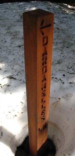
Dardanelles Lake Trail Junction
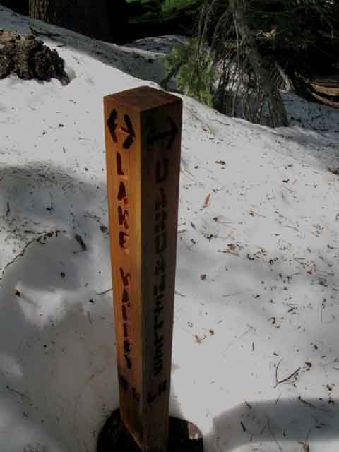 |
The new trail post has returned to the old "Lake Valley" designation of Christmas Valley. Nice. |
Dardanelles Lake Trail Junction
INFORMATION
South Upper Truckee Road Trailhead
|
|
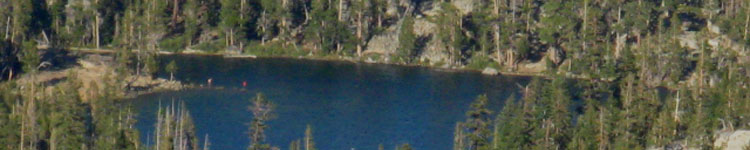
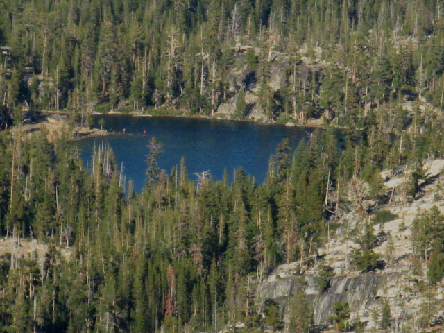
Dardanelles Lake from Above
| View of Dardanelles Lake from near Showers Lake. | ||
 |
||
This view is from the West of Dardanelles Lake hiking South from Echo Summit to Showers Lake. We can't see Dardanelles Lake from the trail junction between South Upper Truckee and Round Lake. Balzacom's notes on his and his wife's cross-country exploration are informative. |
Post up notes and advice about your hikes and backpacking trips into Dardanelles Lake. |
Hiking Above the Dardanelles Trail Junction
The Trail South
 |
View Southeast hiking Southeast climbing above the Dardanelles Lake trail junction on our way to Round Lake. We will shortly encounter the Big Meadow trail junction branching off to the Northeast. |
Ari on the Trail
 |
Looking North at Ari between the Dardanelles Lake and Big Meadow trail junctions. We can see the valley our tributary follows up the mountain is opening up a bit. |
South: Christmas Valley Burnt Area North: Big Meadow Trail Junction
Dardanelles Lake Trail Junction |
Short Sweet Backpacking Trips A fine short local trip out of The South Upper Truckee Road is to Dardanelles Lake. Dardanelles Lake is located a total of 3.72 miles from the South Upper Truckee Road trailhead. This is a very easy trip, due to the short distance. But it is steep up to the Dardanelles trail junction. If you are just starting to backpack, a trip up to Dardanelles Lake offers a fine introduction to High Sierra backpacking. It's a little bite, but it has bite. Take one night at Dardanelles Lake, then take the next short but steep 1.95 mile hike up to Round Lake for night two. The next day after that we will have the steep 4 mile downhill hike to and out of the mountains through the South Upper Truckee Trailhead. Though the trail up to the Dardanelles Lake trail junction is steep and difficult from the South Upper Truckee trailhead, it is not far, and the short distance allows us to take our time. Big Meadow Trailhead For an even easier trip to Dardanelles Lake, we can enter through the Big Meadow trail head on Highway 89. From this trail head it is 2.68 miles down to the Big Meadow-Round Lake trail junction, pictured on the next guide page South. Turn North, (Right) down mountain from the Big Meadow-Round Lake junction to hike a quarter-mile down Christmas Valley to this Dardanelles Trail Junction. The Dardanelles Lake trail junction is 1.14 miles from Dardanelles Lake. From the Big Meadow trailhead on Highway 89 to Dardanelles Lake our hike is around 4.05 mostly downhill miles. In other words, the Big Meadow trail head offers very easy access, much easier than the South Upper Truckee trail head, to Dardanelles Lake. The easiest trip to Dardanelles Lake starts at Big Meadow Trailhead on Highway 89 down to Dardanelles Lake, then exits by hiking down through the South Upper Truckee Trailhead. This particular trip is almost all down-mountain. Our other option when we are backpacking in through the Big Meadow trailhead is to turn South, or left, when we hit the Round Lake trail junction to hike the remaining .58 mile up to Round Lake's most beautiful campsites and vistas. See the trail guide pages that follow this page South, or click on the "This Map" link at the top of this page to locate these trail junctions and lakes on the USGS 7.5 maps. Though I do not use the Big Meadow trail head too often, it makes access easy for those too weak or lazy to get to Round Lake or Dardanelles Lake coming up from the South Upper Truckee Trailhead. It's a great first step into Sierra Nevada backpacking. Big Meadow Trailhead is a great place to break in kids, old folks, or see how we are recovering from injury, if we are not launching a big hike down the Sierra Crest. I recommend and prefer coming up from the South Upper Truckee Trailhead. This is one of my favorite local areas for four-Season travel in the Tahoe Basin. It was here that I first began exploring Winter travel in the High Sierras. The reasons are rather simple. First, I am very familiar with the area and terrain. Knowing the terrain is vital for your first snow trips. Second, there are relatively easy escapes if things go wrong: Highway 88 to the South, Highway 50 to the North, and Highway 89 to the East. And finally, all of these highways make it easy to hitch in and hitch out from any of the trail heads. Check out Balzacom's notes about cross country travel here. Information 7.5 Hiking Topo Map 30 min Hiking Topo Map Next page South |
Backpacking Trail Guide North |
 |
Backpacking Trail Guide South |
Backpacker ForumsGeneral Sierra Nevada hiking thoughts to relate? Post 'em on
On the Forum you can browse trail locations and add your experiences, comments, questions (& pictures and videos if you Register...) about hiking South out of the South Upper Truckee trailhead. General comments about the South Upper Truckee to Carson Gap section of the High Sierra trails, or this particular location: Section
|
South: Christmas Valley Burnt Area North: Big Meadow Trail Junction
Trailhead
Contact
Alex Wierbinski

Backpacking Lake Tahoe to Mount Whitney
Your guide to the High Sierra Crest, including the Tahoe to Yosemite, Pacific Crest, and John Muir Trails
