

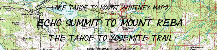

Echo Summit to Lake Alpine
The Big Picture: The Tahoe to Yosemite Trail through the Meiss Roadless Area, the Carson Pass Management Area, and the Mokelumne Wilderness
30 minute USGS Topo Backpacking Maps

| TYT TOPO MAPS | TYT TRAIL GUIDE |
Maps: PCT South |
Tahoe to Yosemite MAPS-MILES |
Weather, Map Data |
||||||||||||||
Maps Index |
TYT |
Detailed |
TYT The Carson Iceberg |
GUIDE |
SOUTH: |
PCT 30 min Map Carson Pass to Ebbetts Pass |
PCT 7.5 min map Carson Pass to Lost Lakes |
PCT Miles and Elevations Carson Pass to Ebbetts Pass |
30 min map: |
7.5 map Carson Pass Region Map |
TYT Miles and Elevations Echo Summit to Carson Pass |
map info | ||||||
| TYT MAPS | TYT TRAIL GUIDE | PCT MAPS | ||||||||||||||||
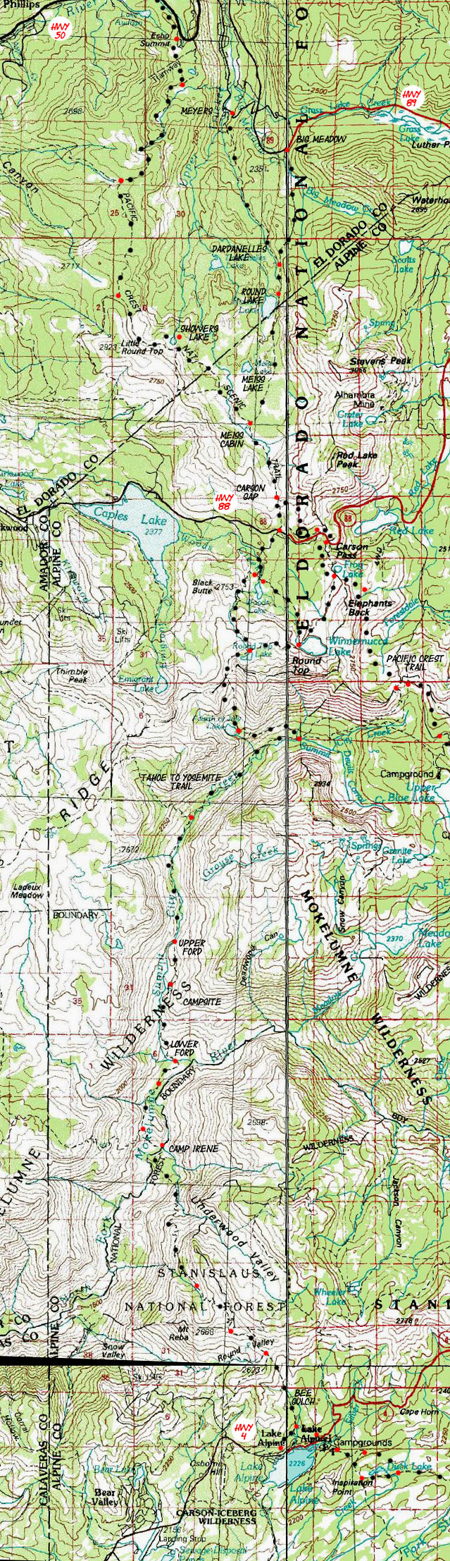
This map covers 38.28 miles from Echo Summit across Meiss Country Roadless Area out of the Tahoe Basin across Western Mokelumne Wilderness to Lake Alpine.
Click
RED and BLACK
DOTS
Top of Topo Map: Meiss Roadless CPMA Middle of Topo Map: Summit City to Bee Gulch Map South on the TYT: Lake Alpine Region Map
Desolation Wilderness Hiking Map Mokelumne Wilderness Hiking Map Carson Iceberg Wilderness Hiking Map
|
Top of Topo Map: Meiss Roadless CPMA Middle of Topo Map: Summit City to Bee Gulch Map South on the TYT: Lake Alpine Region Map
7.5 MAP North of this map on combined PCT-TY Trails: Echo Summit to Echo Lake
|
|
Main Features: From Echo Summit the Tahoe to Yosemite and Pacific Crest Trails share the same route heading South thorough the Meiss Country Roadless Area to the Carson Gap. The Meyers-Christmas Valley-Big Meadow trail junction at Meiss Cabin is where the Tahoe Rim Hiker turns North. This junction is the Tahoe Rim Trail's Southernmost point. This junction also leads down to the Meyers Trailhead shown on the Eastern side of the map. Just below the top of this map the Tahoe to Yosemite trail splits from the Pacific Crest Trail at the Carson Gap. See the Carson Pass Region Map for a detailed look at this trail junction and your options for hiking South on either the Tahoe to Yosemite Trail or the Pacific Crest Trail through the Carson Pass Management Area. The center to bottom of this topo map focuses upon the Tahoe to Yosemite Trail from Round Top Lake to the end of this section of trail at Lake Alpine on Highway 4. You will notice some minor innacuries in the trail route on this map that I have not bothered to correct. I have corrected the outdated and changed section of the route on the detailed maps and noted these changes on the trail guide pages. The reason I did not alter this topo hiking map is this map presents a broad overall context of the Tahoe to Yosemite Trail in relation to the trans-Sierra Highways and potential side trails and nearby trailheads from which you can carve short and medium distance backpacking trips into these remote terrains. Also note that the accumulation of these route alterations over time is the cause of mileage inaccuries on the trail posts and in the trail guides. The routes are being constantly rerouted by man and nature, leaving mileage figures inaccurate. As I've hiked these trails for decades I've become somewhat familiar with the slow changes in the routes compared to the static depictions in the USGS topo maps. I've measured the miles for this guide using the figures given by trail signs compared with measurments of the modified routes rather than the old trail routes. The miles I read out will be adjusted with changes in the trail and input from you. |
High Sierra Road Map
North Sierra Trans-Sierra Highways LAKE TAHOE TRAILHEADS
HIGHWAY CORRIDORS ROAD MAP Sonora Pass (PCT) and Clarks Fork Road and Saint Marys Pass (TYT) This is a road map for highway access to the trailheads on the South end of the trail map above. Centered On
|
|
||
Miles and Elevations South Miles Echo Summit to the Carson Gap: 10.61 miles Echo Summit to Carson Pass Miles and Elevations North Miles Echo Summit to the PCT-TY trail Junction at Middle Velma Lake: 19.21 miles Echo Summit to Meeks Bay Trailhead: 30.71 miles Meeks Bay to Echo Summit Miles and Elevations
Continuing South from the Round Lake Junction on the Tahoe to Yosemite TrailRound Top Lake Junction is the new mileage Zero Point This section of the guide measures mileage South from our exit from Lake Tahoe Basin at the Carson Gap to Lake Alpine. As there are three routes from the Carson Gap up to the trail junction at Round Top Lake, you either have walked 3.9 miles from the Gap to Round Lake via the footbridge route, 3.4 miles via the Lost Cabin Mine route, or 4.57 miles from the Carson Gap to Round Top via Carson Pass and the Winnemucca Lake trail junction. To simplify measuring trail mileages further South the Round Top Lake trail junction where these 3 routes all converge is the new zero-point for measuring distances to the Bee Gulch Trailhead located on Highway 4 at the East side of Lake Alpine. Round Top Lake Junction 9360 0 -1196 2.3 Fourth of July Lake 8164 2.3 -724 1.31 Summit City Creek Junction 7440 3.61 *** *** Boy Scout Camp *** *** (Summit City Junction to Horse Canyon) -560 2.43 Horse Canyon 6880 6.04 -160 .8 Telephone Gulch 6720 6.84 Rock Zone *** *** (Telephone Gulch to Upper Ford) -160 1.71 Upper Ford 6560 8.55 -440 1.32 Water/Nice campsite 6120 9.87 *** *** Water *** *** (Campsite to Lower Ford) -580 1.19
Lower Ford Summit City 5540 11.06
Ducked path to Forest *** *** (Lower ford to forest) -20 .32 Unblazed forest 5520 11.38 -40 .71 Forest to Munson jnct 5480 12.09 +160 .47 Munson Meadow Junction 5640 12.56 -360 .57 Camp Irene 5280 13.13 +3440 5.24 top of Mt Reba 8720 18.37 -280 .87 Bee Gulch Junction 8440 19.24 -2254 1.4 Trail Jnct above Lodge 6186 20.64 1134 .51 Hwy 4 Bee Gulch Trailhead 7320 21.15 +40 .34 Al's hidden Camp 7360 21.49 21.49 miles is measured from the Round Top Lake Junction to my campsite behind (East, up Silver Creek) the backpacker's camp on the East Side of Lake Alpine. |
Map Name: Placerville Calif, 1976, 30 minute USGS Topographic Map: Smith Valley, 1985, 30 minute Map: Bridgeport, 1985, 30 minute Map: San Andres, 1993, 30 minute The order of maps rotates clockwise from the upper left. Compass Offset: Magnetic North is 17 degrees East of True North scale: 1:100 000 Contours: 50 meters
Map Coverage Echo Summit to Mount Reba on TYT North Side Backpacking Permitting Authority Echo Summit to Carson Gap National Forest: Lake Tahoe Basin Management Unit TW information: Meiss Country Roadless Area Fed information: Meiss Country Roadless Area
South Side Backpacking Permitting Authority Carson Gap & Carson Pass around Round Top National Forest: El Dorado National Forest TW information : Carson Pass Management Area Fed information: Carson Pass Management Area
South of Round Top to Mount Reba National Forest: El Dorado National Forest TW information : Mokelumne Wilderness Fed information: Mokelumne Wilderness Physical location The Meiss Roadless Area lays Between Highway 50 to the North, Highway 89 to the East, and Highway 88 to the South. The Tahoe to Yosemite Route crosses the Mokelumne Wilderness through the Western flank of the Sierra Nevada between Highway 88 to the North and Highway 4 to the South. Carson Pass Resources on the Federal Websites Crossing Highway 88 South puts you into the Carson Pass Management Area. South on the Tahoe to Yosemite Trail Heading South of the Carson Pass on the Tahoe to Yosemite Trail puts you into the Western section of the Mokelumne Wilderness, which is administered by the El Dorado National Forest South on the Pacific Crest Trail Heading South of the Carson Pass on the PCT puts you in the Mokelumne Wilderness administered by the Toiyabe National Forest.
North of this Topo Map: Desolation Wilderness |
|
next map North: Carson Pass Region Map next map South: Lake Alpine Region Map
| Elevations High and Low | More Information | ||
Lake Tahoe: 6225 feet Echo Summit : 7377 feet Carson Gap : 8800 feet Round Top Lake: 9360 feet Camp Irene: 5280 feet Mount Reba: 8720 feet Lake Alpine: 7303 feet |
Trail Guide Section: Lake Tahoe to Highway 4 Miles: Echo Summit to Carson Pass Google Trailhead Road Maps |
||
Map CreditFree USGS Topo Hiking Maps |
U.S. Geological Survey, Department of the Interior: The USGS I love these folks. Move the Map to the Sierras. Select size of Maps you wish to locate. Click "Mark Point" on map to see the USGS map grid of the selected map scale. Set up folders to download these bad boys into, then fire them up in Adobe Reader. USGS Topographic Maps |