


Meiss Country Roadless Area Backpacking Map
Hiking the Tahoe to Yosemite, Pacific Crest and Tahoe Rim Trails
Four
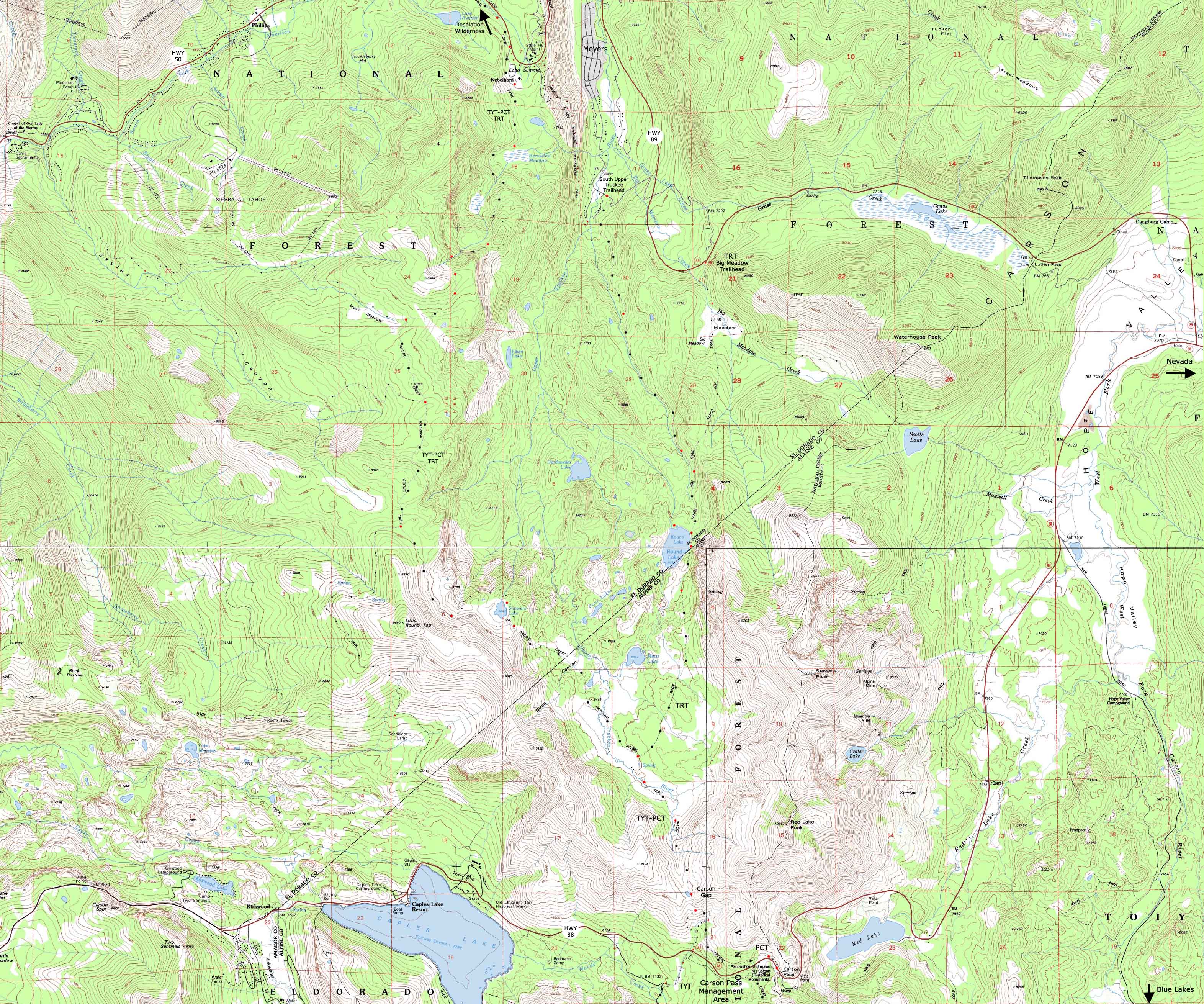
USGS 7.5 minute Backpacking Topo Map of Echo Summit and South Upper Truckee Trailheads to The Carson Pass
MAPS |
GUIDE |
7.5 min PCT-TYT |
7.5 min TYT-PCT |
Miles |
Miles |
Trail Guide |
30 minute |
Click |
WEATHER |
RESUPPLY |
PERMITS |
Echo Summit, South Upper Truckee, and Big Meadow Trailheads to Carson Pass
Echo Summit to Carson Pass miles and elevations CLICK RED DOTS Meyers to Carson Gap miles and elevations
| North Dicks Pass to Echo Summit |
North Echo Summit to Echo Lake DETAIL Map |
South Carson Pass Region Map |
|
| North Dicks Pass to Echo Summit |
North Echo Summit to Echo Lake DETAIL Map |
South Carson Pass Region Map |
30 min version of this map: Echo Summit to the Carson Pass
Location |
||||
Main Features Excepting the Tahoe Rim Trail, who's turn Northeast at the Round Lake Trail junction near Meiss Cabin marks this trails furthest point South before it circles North following the Lake Tahoe Rim, independent of which way you are hiking it. Visit Showers Lake, Meiss Lake, and Meiss Cabin on your way South on the main High Sierra Trails. Or come out to visit this pretty area for a couple of days of fine local backpacking to warm up for the long trails.
Map Anomalies South of Echo Summit Showers Lake South Upper Truckee Trailhead
MAP NOTE What's important for our general reference purpose is that each side of a square is 1000 meters, or a Kilometer. From my point of view that is 1093.6 yards or .62 of a mile. Diagonal: 1414.22 meters, if my trig is correct. That converts the diagonal distance into 4,639.8 feet or .88 of a mile.
|
| Road and Trailhead access to Meiss Country Roadless Area |
||||
| NORTH & EAST Highways 50 and 89 Echo Summit with South Upper Truckee and Big Meadow Trailheads |
SOUTH Highways 88 Carson Pass |
|||
More
|
||||
Mapping Information |
|
Mileages Backpacking Miles: Meiss Roadless Ares The trail South from Echo Summit to Carson Pass is a roller coaster from Echo Summit to Showers Lake. After Showers you drop down into Meiss Meadow, where you begin a gentle climb up to the Carson Gap, where the Tahoe to Yosemite and Pacific Crest Trails diverge. Location Elevation Mileage Start: Echo Summit 7377 0+143 .91 Duck Lake trail junction 7520 .91 +1000 2.58 Sayles Canyon/Bryan Meadow jnct 8520 3.49 +440 2.12 Schneider's Camp junction 8960 5.61 -160 1.19 1st Showers Lake junction 8800 6.80 -120 .41 2nd Showers Lake junction 8680 7.21 +280 1.88 Round Lake trail/Meiss Cabin 8400 9.09 +400 1.52 Carson Gap Pond 8800 10.61 The Tahoe to Yosemite and Pacific Crest Trails Part CompanyPCT/TY trail junction looking South towards Round Top Just South of the Carson Gap is the 1st Southbound Junction between the Pacific Crest Trail, which continues East to Carson Pass, and the Tahoe to Yosemite Trail, which turns right, and straight down to Highway 88, off an unmarked trail junction just South of the Carson Gap. The Pacific Crest Trail continues to follow the main trail towards Carson Pass: Carson Gap Pond 8800 10.61 -200 1.39 PCT to Carson Pass 8600 12.00 ...Tahoe to Yosemite Trail Junction #1Shortly South of the Carson Gap, an unmarked trail junction appears on our right, and heads almost straight down to Highway 88 towards Woods Lake. Carson Gap 8800 10.61 -400 .6 to Hwy 88 8400 11.2 The Second Tahoe to Yosemite trail junction lays just South of Carson Pass, where the trail branches off to join the trail down from the upper junction towards Round Top Lake via Woods Lake.
Previous Trail Segment: Meeks to Echo Miles and ElevationsNext Trail Segment
|
4 Maps NE SW SE
Compass Offset
scale Contours
Backpacking Permitting Authority Lake Tahoe Basin Management Unit TahoeWhitney Feds Website
National Forest LTBMU Wilderness AreaMeiss Country Roadless Area, TahoeWhitney Meiss Roadless Area, feds
Physical location:The Meiss Country Roadless Area is bounded by Highway 50 on North, Highway 89 on East, and Highway 88 to the South* * *
Download Free USGS Topo MapsINSTRUCTIONS 1>Locate the position you need a map for on the google map. 2>CLICK the MARK POINTS mode. 3>Select the size of MAP FOOTPRINTS you wish to see. 4>CLICK the Map Footprint you want to down load. This will leave a red marker on that map footprint. 5>CLICK the red marker, and the maps available for you to download will appear. 6>Select and download the map you need. NOTE: These are "GEO Maps" that load in Adobe Reader with many cool functions. If you want to manipulate and print custom sections, you must first load the map into MS Paint before it can be manipulated in PhotoShop. * * * |
map North: Echo Lake to Echo Summit map South: THE CARSON PASS
| Elevations | More Information | ||
Lake Tahoe Echo Summit Trail head Upper South Truckee Trailhead Carson Gap, Exiting Tahoe Basin |
Trail Guide, Section Trail Guide, Segment Trail Guide, Segment Google Map |
||
Map Credit |
U.S. Geological Survey, Department of the Interior The USGS Download free USGS topo maps: Move the Map to the Sierras. Select size of Maps you wish to download. Click "Mark Point" on map to see the USGS map grid of the selected map scale. USGS Topographic Maps |