
High Sierra
Backpacking
Trail Guide
Forums
Sierra
Weather
WeatherNotes Northern
Sierra Weather
Gear
Backpacking
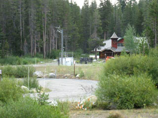
South from Echo Summit towards Carson Pass
Hiking to Showers Lake across Meiss Country Roadless Area
Languages
Trail Skills
Mountain
Safety
Food
Planning
Trail Arts
More
Information
Social
| Trail Guide INDEX |
North Echo Summit |
South Tahoe Rim, Frog Lake |
Topo Trail Map Echo Summit to Carson Pass |
Trail Maps INDEX |
Trail MILES and ELEVATIONS |
Trail Miles and Elevations INDEX |
Tahoe to Whitney on YouTube |
Hiking
across the
Southwestern Edge of the Lake Tahoe Basin
Hiking South out of Echo SummitDeparting Echo Summit Southbound we are beginning to trace out the South-Westernmost perimeter of the Tahoe Basin on a grand arc gradually bending to our Southeast. This arc terminates 10.61 miles South of our current position at Echo Summit Trailhead at the point where we exit the Lake Tahoe Basin through the Carson Gap. We will also be exiting the Lake Tahoe Basin Management Unit with the same step. Check out the topo map; Click the red dots on the map to see the trail guide entries for each location. Add your updates and perspective through the comments links for each segment of the trail.
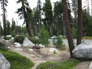
Terrain Physical Character Well, our trail South to Showers Lake can be generally characterized as being composed of one great climb up to near the top of Peak 8905, followed by a moderate descent from there down to Showers Lake. Up and Down The roller coaster nature of the trail was cut into the terrain by the last Ice Age, and it has been magnified by subsequent erosion, foresting, and design. Trails are designed to minimize terrain movement, which can cause lots of extra backpacker movements. This is a solid Intermediate 1 Trail for the next 2.89 miles South from Echo Summit Trailhead up to its highest point crossing Peak 8905. This segment of our trail climbs 1383 feet up to 8760 feet crossing Peak 8905 over the next 2.89 miles. A TOOLBOX of POTENTIAL All three trails break off to the Southbound Backpacker's Right, West by the compass. All three bring us to trailheads outside the Tahoe Basin, the Norther Sayles Canyon junctions leading down to Sacramento Camp on Highway 50 while Schneiders Camp is on Highway 88 West of Carson Pass North of Caples Lake. The map below shows us these 3 trails are each suitable for planning interesting "U" trips into Meiss Country from Echo Summit Trailhead ending or beginning through these two trailheads along Highways 50 and 88.
|
 |
Video
Views of Christmas Valley
and the
Meiss Country Roadless Area
from just
South of Echo Summit Trailhead
to just
North of Sayles Canyon trail junction.
| Exploring the Rock and Forest South of Echo Summit. | |
The Southwestern Tahoe Rim is composed of Beautiful Rock Formations along an amazing volcanic interface clad in deep forest lower down, meadows and mountains above.
Echo Summit Forum
|
North: Echo Summit South: Tahoe Rim, Frog Pond
Three Trails South of Echo Summit
TYT, TRT, & PCT
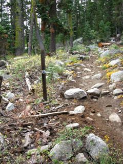
Echo Summit SouthboundTerrain Physical Character II The trail is plain to see yet completely over-posted. Passing South of the parking lot we observe the trail turns South to begin a gentle traverse up into dense forest.
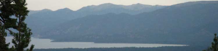
Local Context CHRISTMAS VALLEY We will follow the Western rim of the Tahoe Basin just below the Sierra Crestline South around the top of the Western edge of Christmas Valley to Meiss Meadow. Meiss Meadow is essentially a great meadow at top of Christmas Valley collecting the runoff from the Tahoe Rim Mountains surrounding the Southernmost end of the Tahoe Basin. A whole lot of sediment has flowed and is flowing across that meadow off the surrounding mountains, down into Lake Tahoe, with much ending up in Pyramid Lake, East of Reno. Long Processes As we hike our first steps South across the fairly steep segment of trail up Peak 8905 on our way Showers Lake we quickly become aware that our long views of Lake Tahoe and Christmas Valley are going to be masked by dense forest, steep rock, and even by the line of our route. This requires us to stop to enjoy and soak-in the long views where we can find them, and focus more on enjoying our close-up study of the terrain than broad overviews, as we proceed South. One Meadow-Two Mountain Ranges Hiking South out of the Tahoe Basin through the Carson Gap we are passing out of the East Sierra drainage of the Tahoe Basin onto the West Flank of the Sierra at the top of one arm of the vast and complex watershed of the North Fork of the Mokelumne River. East Flank
South Upper Truckee River
Backpacking Map South
Below us in Christmas Valley we can see where the trail out of the South Upper Truckee Road Trailhead tracks up Christmas Valley under dense forest past Round Lake to Meiss Cabin in Meiss Meadow. That's where the route up from Meyers intersects with our PCT-TYT-TRT trail South out of Echo Summit Trailhead. In that image we can make out the arm of forest reaching across Big Meadow down into the line of this Eastern tributary of the South Upper Truckee. TRT BREAK OFF
From this overview-point behind Magic Mountain we have but a short hike South to a small meadow-marsh that is filling in with lodgepoles. This is where the Frog Pond Loop breaks off from the Pacific Crest Trail. |
Well posted
(or well over-posted)
Southbound trail
out of
Echo Summit
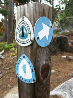
Tahoe Rim Trail
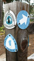
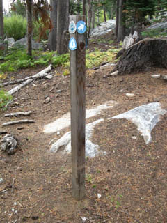
Tahoe Rim Trail Emblems proliferate. |
| Though the trail bed is deeply cut into the soil and easy to follow, there are many trail posts and trail emblems leading us from Echo Summit Trailhead to the junction with the Frog Lake trail loop. |
 |
 |
|
| The Next Post, Southbound. | Close up. | |
 |
||
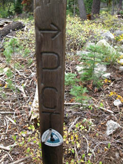
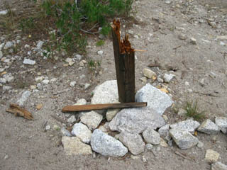
| Sometimes the bears just rip up the sign posts, other times they destroy them using them as itching sticks. Over posting problem solved! | ||
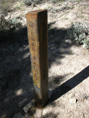
Bear Note It appears to me that there is such a thing as "cranky bears." Most times the bears are breaking trail posts by using them as itching sticks. But there are other times it appears that the bears are intentionally taking them down. In some areas the local bears decide that they don't like anything human in their territory. They then proceed to constantly rip up every trail post the trail crews put up. The Carson-Iceberg Wilderness experienced this in and along the East Carson River, including the Golden and Murray trail junctions on the Pacific Crest Trail for years. The bears even targeted the Soda Springs Ranger Station until they put up a solar-powered electric fence around it. They would put up a post, and the bears would quickly take it down. Seriously!! In recent years the Carson-Iceberg has switched to STEEL posts that have the destinations cut into them. Problem Solved! |
||
 |
||
| Above: Steel trail post in the Carson-Iceberg Wilderness. Is this the future of trail posts? | ||
| top of page |
North: Echo Summit South: Tahoe Rim, Frog Pond
A Very Easy Day: Echo Summit to Showers Lake |
|||
Hiking PlanDeparting Echo Summit Southbound makes Showers Lake our next destination. After Randy hit me up with a bunch of killer calories, I now had some screwing off time. Extra food had opened up my schedule a bit. So I hung out with Randy at the Echo Summit trailhead for a couple of hours, and subsequently decided to maintain the theme of an easy day that I had established with Randy. Therefore we would spend the rest of the day getting to, or hanging out, at Showers Lake, located just 6.8 miles to the South. This would put today's total miles at 7.8 miles during a half-day of backpacking. No big deal! These extra calories would work out well as we continue South down the trail, giving a bit of slack we can enjoy time with the fine people and perspectives we run into on the trail. We've got the food to cover some tarrying.
Next page |
Backpacking Trail Guide North |
 |
Backpacking Trail Guide South |
Backpacker ForumsGot something to say? Say it here:Post it on Also see the Tahoe to Whitney trail Section and Backpacking Topics Forums.
Below you can add your experiences, comments, questions or pictures and videos about hiking South out of the Echo Summit Trail Head, or general comments about the Echo Summit to Carson Pass section of the trail forums: Section
|
North: Echo Summit South: Tahoe Rim, Frog Pond
Trailhead
Contact
Alex Wierbinski

Backpacking Lake Tahoe to Mount Whitney
Your guide to the High Sierra Crest, including the Tahoe to Yosemite, Pacific Crest, and John Muir Trails
