

The Trails
Guide
Maps
Miles/Ele
Permits
Resupply
Forum
Current Weather Conditions
Weather Notes
Northern High Sierras
Central High Sierras
Southern High Sierras
Gear
Gear List
Gettin Started
Layering
Discussion
Testing yourself and your gear
Gear Reviews
Backpacking
South of Echo Summit
Tahoe Rim Trail, Frog Lake Winter Loop
Languages
Languages
Trail Arts
The art of walking
Physical Preperation
Trail Skills
The trail
Off the trail
Scrambling
Maps
Navigation
Camp skills
Food
Resupply
Food
Other
Photo Catagories
Trail Stories
Trail Culture
News and Science
Links
Groups
Books
Terms and Conditions of Use
Continuing Backpacking Map South This is a blazed blue diamond Winter route. At least out to the Frog Lake Loop. I've also noted that we start picking up the Winter blue diamond trail near the top the Southeast flank of Peak 8905. I visit Showers Lake during Winter hiking South out of the Meyers Trailhead as part of a triangle route to Round Top Lake and back to the South Upper Truckee Trailhead. I've been scouting the route in from Echo Summit for suitability as an additional Winter route to Showers Lake. The steep sections will require very good snow conditions. I'd hike the trail to comfortable familiarity during Summer before attempting it during Winter. UPDATE I generally come into the Meiss Country Roadless Area up the big climb from the South Upper Truckee Trailhead out of Meyers to Round Lake, then use one of three routes I follow from Round Lake up to the East, Center, or Meiss Lake parts of Meiss Meadow. Very nice hikes, Summer and Winter. Post up your Winter Experiences here in Echo Summit-Meiss Roadless Area Snow Routes Weather
There is a Winter marked route around Frog Pond from Echo Summit, a marked snow trail along Hwy 50 West from Echo Summit, and a nice route from near Camp Sacramento at the Sayles Canyon Trailhead on Highway 50 up through Sayles Canyon to overlook the Tahoe Basin near the Sayles trail junction just to our South. I have wondered about connecting the Sayles with Echo Summit Winter routes, but have not had the chance to explore further. Post up below if you have. It looks like a nifty snow journey. Check out the 30 minute map of Meiss Country Roadless Area including the trails up from Highway 50 at the Sayles Canyon Trailhead: Echo Summit to Round Top Connecting access to the Tahoe Rim from the trail up Sayles Canyon with the trailhead at Echo Lake during Winter would be an extremely difficult trip. The route between the end of the Frog Lake Loop and the Sayles trail junction would be very difficult in Winter. I figure it would be do-able after the snowpack compressed well, such as during late Winter or early Spring of a "typical" snow season. Have you snow shoed or skied over that route during Winter? Give us a heads up on the route, conditions, and hazards! Echo Summit-Meiss Roadless Area Snow Routes
|
|||||||||||||||||
Mighty Mike
Tahoe Rim Trail |
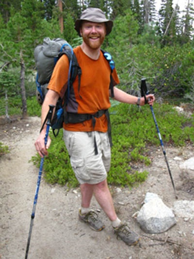 |
| Mighty Mike, loving the Tahoe Rim Trail |
Mike
|
I hit Mike up for an account of his Tahoe Rim backpacking trip, and here's what we have, so far: Tahoe to Whitney Forum, Mike's Brief Account Information Link |
North: North to Echo Summit South: Tahoe Rim to Showers
Information
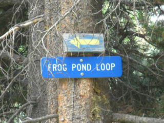
Frog Lake Loop JunctionElevation Mileage Backpacking Map South |
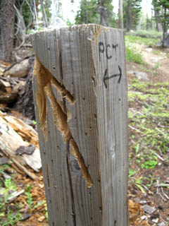
Bicycles Prohibited on the Pacific Crest Trail
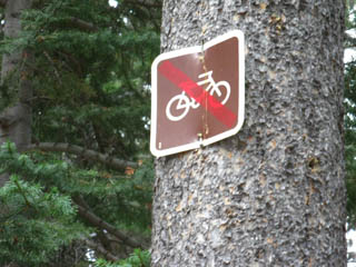 |
| Bikes are not allowed on the Pacific Crest Trail. This sign prohibits bikes past the Frog Lake Loop. |
The Lake Tahoe Basin Management Unit Bikes appear to be allowed on all trails that are not part of a wilderness area, nor part of the Pacific Crest Trail, which bars bike travel. Everything else seems to be open territory for mountain bikes. All the mountain bikers I've met along the trails in the LTBMU are generally real good people. But, that does not alter the fact that the physical impact of bicycles trashes the trails. The deal is the local ski resorts up and down the Sierra Crest have been looking for more customers with the decline of Winter skiing revenues over the past twenty years. The resorts have made a concerted effort to draw mountain bikers to their slopes during Summer, and this is echoed by the elements of the population who depend on tourism for a living. Lots of trails are open to mountain bikers, but the wilderness areas all prohibit mechanized devices. Definitions: Wilderness Area |
 |
 |
|
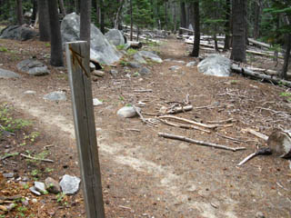
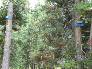
Snow Travel Sign in the Tree |
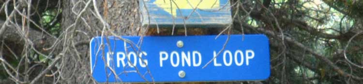
It's the Frog Lake Loop! | |
North: North to Echo Summit South: Tahoe Rim to Showers
Meiss Country Roadless Area |
|||
Getting to the Frog Pond Loop trail junction means we are now getting into the meat of the Meiss Roadless Area, which extends from Echo Summit to the Carson Gap. The terrain will now begin to increase in both difficulty and beauty. Soon we will winding our way over and around the multiple drainages that bring the Spring runoff down from the Tahoe Rim to Lake Tahoe via the South Upper Truckee River through Meyers. The South Upper Truckee trailhead and River lay below and to the East of our position above Christmas Valley.
Next page |
Backpacking Trail Guide North |
 |
Backpacking Trail Guide South |
Backpacker ForumsHave backpacking issue to relate?Post it on On the Forum you can browse the locations and add your experiences, comments, questions (or pictures and videos) about hiking South out of the Echo Summit Trail Head.
General comments about the Echo Summit to Carson Pass section of the trail: Section
|
North: North to Echo Summit South: Tahoe Rim to Showers
Trailhead
Contact
Alex Wierbinski

Backpacking Lake Tahoe to Mount Whitney
Your guide to the High Sierra Crest, including the Tahoe to Yosemite, Pacific Crest, and John Muir Trails
