Previous Years
2019
2018
2017
THIS YEAR'S
News, Views, & Issues
LAST YEAR"S
News
2020
High Sierra
Backpacking Calendar
2020 INDEX
January February March April May June
July August September October November December
November
2020
Last Week in October
Week 1
Week 2
Week 3
Week 4
Week 5
TRAILHEAD
Last Year
November
2020
Looking back at the two Palisades Lakes below, with the Palisade Range
rising to their Right as we climb through shattered rock to Mather Pass
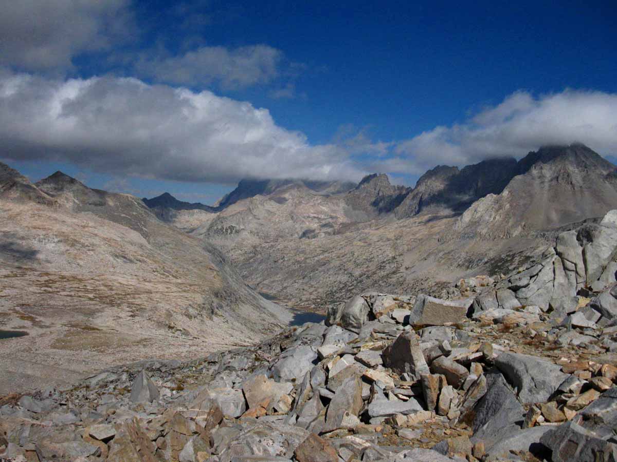
Turning around to take a last look at the Pallisade Lakes below, the Palisades Range surrounding them on the Right, and us hiking through the shattered rock leading South to Mather Pass.
Trail Guide Map Miles and Elevations: Not yet online
November 2020
Top of Page
January February March April May June July August September October November December
| Sunday |
Monday |
Tuesday |
Wednesday |
Thursday |
Friday |
Saturday |
NOVEMBER 2020
Deploy Winter Gear
Our “base” layers are typically brought from Fall to Winter Standards during the month of November.
Our shell layers are thickened to Winter Standards as well.
Winter Shell, boots, socks, gloves and camp gear all come into play. I love my down snow-camp booties!
Retire the water filter and bear canister.
Probabilities of Overnight Freezing Next Five Days
Current Weather Map
THINKING ABOUT NEXT YEAR?
You Should be...
November is the time to begin thinking about reserving permits in Desolation Wilderness or Yosemite National Park for next June. Half of each ‘s Wilderness Permits at these heavily used areas are available six months before the start date of the backpacking trip
2019 Status
2018 Status
The beginning of November has brought us One Storm since May, beeing the mini-downpours that happened on the second day of October. We are currently experiencing another Drought Fall, Otherwise known as, the, "New Normal."
2017 Status
Despite last Winter's extreme snowpack cancelling the early & middle of the Summer of 2017 Backpacking Season (for all but the strongest & most skilled) before it melted out, the end of the Summer into Fall turned brutally tropical HOT & DRY, again bringing record temps, record fires, vast smoke coverage, and sure looking exactly like every one of the last 7 or 8 preceeding, "drought Falls."
Except for last Winter's massive snowpack, you'd think the drought never really ended.
We need another wet Winter to put another nail into the drought's coffin. Let's watch how this Winter Evolves.
What Brings This Winter of 2017-2018?
Predictions and Probabilities for the Upcoming Winter
We enter November 2017 coming off
a
HEAT WAVE
moderating into
Temperate Weather
&
First Substantial Storm approaching
Winter of 2018
WINTER GEAR REQUIRED
November 3
2016 Status
High temp storms out of the Southwest have been bringing
wet and snow conditions to the High Sierra. Wet and Cold conditions create a special kind of hazard that must be anticipated.
Early storms in Oct 2016 brought some drought relief to North Cal and snow along the whole Sierra Crest, it did little to alleviate SoCal Drought
We enter November 2016 with
a
COLD & WET GEAR ALERT
More
High Sierra
Backpacker
Information
High Sierra
News of Nature & Science for Backpackers
LET'S GO BACKPACKING
Guide Trailhead
Guide Index
High Sierra Magazine
Blog-Forums
MORE
Navigation Information
Time & Space
High Sierra Backpacker
Trail Skills
|
26
LAST MONTH
NEXT WEEK
TOP |
27
|
28
|
29
This Week
TOP
|
30
|
| Sunday |
Monday |
Tuesday |
Wednesday |
Thursday |
Friday |
Saturday |
1
LAST WEEK
NEXT WEEK
TOP |
2
|
3
|
4
This Week
TOP |
5
|
6
|
7
|
| Sunday |
Monday |
Tuesday |
Wednesday |
Thursday |
Friday |
Saturday |
8
End of Daylight Savings
Spring Forward, Fall Back...
DAYLIGHT SAVINGS TIME
THE DST RULES
NIST
PDT
Information
Move clocks one hour back in time.
Why do we think we can manipulate Time & Nature, when the main thing we are changing, screwing-up, is ourselves?
Well, Nature too...
|
9
LAST WEEK
NEXT WEEK
TOP |
10
|
11
This Week
TOP
|
12
|
13
|
14
|
| Sunday |
Monday |
Tuesday |
Wednesday |
Thursday |
Friday |
Saturday |
15
LAST WEEK
NEXT WEEK
TOP
|
16
|
17
|
18
This Week
TOP |
19
|
20
|
21
|
| Sunday |
Monday |
Tuesday |
Wednesday |
Thursday |
Friday |
Saturday |
22
LAST WEEK
NEXT WEEK
TOP
|
23
This Week
TOP |
24
|
25
|
26
|
27
|
28
|
| Sunday |
Monday |
Tuesday |
Wednesday |
Thursday |
Friday |
Saturday |
29
.
LAST WEEK
NEXT MONTH
Top
|
30
|
31
2018 Calendar
|
1 |
2 |
3
This Week
TOP |
4 |
NOVEMBER 2019
| Sunday |
Monday |
Tuesday |
Wednesday |
Thursday |
Friday |
Saturday |
LAST MONTH
NEXT WEEK
TOP
Deploy Winter Gear
Our “base” layers are typically brought from Fall to Winter Standards during the month of November.
Our shell layers are thickened to Winter Standards as well.
Winter Shell, boots, socks, gloves and camp gear all come into play. I love my down snow-camp booties!
Retire the water filter and bear canister.
Probabilities of Overnight Freezing Next Five Days
Current Weather Map
THINKING ABOUT NEXT YEAR?
You Should be...
November is the time to begin thinking about reserving permits in Desolation Wilderness or Yosemite National Park for next June. Half of each ‘s Wilderness Permits at these heavily used areas are available six months before the start date of the backpacking trip
2019 Status
2018 Status
The beginning of November has brought us One Storm since May, beeing the mini-downpours that happened on the second day of October. We are currently experiencing another Drought Fall, Otherwise known as, the, "New Normal."
2017 Status
Despite last Winter's extreme snowpack cancelling the early & middle of the Summer of 2017 Backpacking Season (for all but the strongest & most skilled) before it melted out, the end of the Summer into Fall turned brutally tropical HOT & DRY, again bringing record temps, record fires, vast smoke coverage, and sure looking exactly like every one of the last 7 or 8 preceeding, "drought Falls."
Except for last Winter's massive snowpack, you'd think the drought never really ended.
We need another wet Winter to put another nail into the drought's coffin. Let's watch how this Winter Evolves.
What Brings This Winter of 2017-2018?
Predictions and Probabilities for the Upcoming Winter
We enter November 2017 coming off
a
HEAT WAVE
moderating into
Temperate Weather
&
First Substantial Storm approaching
Winter of 2018
WINTER GEAR REQUIRED
November 3
2016 Status
High temp storms out of the Southwest have been bringing
wet and snow conditions to the High Sierra. Wet and Cold conditions create a special kind of hazard that must be anticipated.
Early storms in Oct 2016 brought some drought relief to North Cal and snow along the whole Sierra Crest, it did little to alleviate SoCal Drought
We enter November 2016 with
a
COLD & WET GEAR ALERT
More
High Sierra
Backpacker
Information
High Sierra
News of Nature & Science for Backpackers
LET'S GO BACKPACKING
Guide Trailhead
Guide Index
High Sierra Magazine
Blog-Forums
MORE
Navigation Information
Time & Space
High Sierra Backpacker
Trail Skills |
29 October
RISING AM WINDS
TEMPERATE
LIGHT LATE PM WINDS
MULTIPLE HAZARDS --FIRE-WIND-SMOKE--
--AIR QUALITY--
NW Sierra
--RED FLAG--
SMOKE & FIRE
HAZARDS
--SACTO--
HANFORD--RENO
Winds rising today.
SACTO
RED FLAG
HANFORD
SMOKE-AIR HAZARD
RED FLAG WED
RENO
LAKE WIND
Hazard Zone
Point Forecasts
West Flank Forecast
Lake Isabella Forecast
Lake Tahoe Forecast
Kincade Fire,
Sonoma County.
CAL FIRE
The Second
Great
PGE
California
Power-Down
Day 4
PGE briefly restoring some power before turning it off for today and tomorrow's rising winds.
Much like
The First Great
Power-Down
Background
Bribed Dems Make Us Pay PGE to Burn Us Down
Our,
"Stewards,"
of
Nature
are
Servants of Greed
The First
Ca-PGE Power-Down
October 9, 2019
TEMPERATE
Days
COLD
Nights
CCC
Backcountry Trail Crew
Applications due
EARLY FEB 2020
|
30 October
RISING MID-AM WINDS
COOL & CLEAR
LIGHT LATE PM WINDS
Firefighter's Progressing
DANGER
Cold Temperatures
Coming
MULTIPLE HAZARDS --FIRE-WIND-SMOKE--
--AIR QUALITY--
NW Sierra
--RED FLAG--
SMOKE & FIRE
HAZARDS
--SACTO--
HANFORD--RENO
Winds rising today.
SACTO
RED FLAG
HANFORD
SMOKE-AIR HAZARD
RED FLAG WED
RENO
LAKE WIND
Hazard Zone
Point Forecasts
West Flank Forecast
Lake Isabella Forecast
Lake Tahoe Forecast
Fire & Smoke
The Second
Great
PGE
California
Power-Down
Day 5
PGE restoring power.
Much like
The First Great
Power-Down
|
31 October
Halloween
COOL & CLEAR
End of Red Flags
(Except LA: To 6pm)
Fire & Smoke
HAZARDS
CONTINUE
HAZARDS
All
Fire & Smoke
Information
Just the Smoke
MesoWest
Ca Report'n Stations
SET FOR
Winds
LAST MONTH
NEXT WEEK
TOP
FULL FALL KIT
REQUIRED
(As of Sept 27)
Gear Lists
GEAR NOTE
Add Winter Gear
Elements
as
REQUIRED
(As of Oct 11)
2019
Sept 12, 2019,
Blob Article
Massive 2019 Blob Forms
11-18
"El Nino El Norte?"
Oct 20, 2019 :
Elements of Blob & Ridge Building-In
2018
RED FLAG WARNING
Weather Notes
1> RED FLAG WARNING,
NW & Central-West Sierra
WINTER OMENS
2> We've had a Big Blob off NW USA, now up in Gulf Alaska, for a while now.
October 2018: The Blob is Back?
SST & El Nino Data
2017
LAST MONTH
NEXT WEEK
TOP |
1
CLEAR & HOT
Hot for November
WARM
Days
COLD
Nights
Informative
"Normal" Vs. Now
Forcasts & Reality
vs.
Averages
Winds? Weather?
NorCal Graphics
SoCal & SW US
Precipitation
Quantitative Precipitation Forecasts:
RAIN FORECASTS
Let's look at the
Big Picture
The Pacific Ocean
Set this for 14 days
&
Display Loop Below
US Weather Map
All Maps
All
High Sierra Weather
And the factors creating it
2018
Snow & Temp Check
LAST MONTH
NEXT WEEK
TOP |
2
CLEAR & HOT
Hot for November
WARM
Days
COLD
Nights
Seven Day
Freezing Temperature Probability
Station Reports
SIXTH
--Fall--
Temp Snow Checks
November 2
2019
Below: Watershed Snow Water Content Charts followed by individual reporting station's Snow Depth and 24 hour high-low temps.
Last Report:
Oct 28
Next Report:
Nov 9
Tahoe Basin
Watershed
Southwest Tahoe
Trail Map with Stations
PCT-TYT-TRT
Rubicon 0.0 −2.0
(0.20) +0.20
7618 feet
Trail Map
56 & 39 +/+
PCT-TYT-TRT
Echo Peak 0.0
(0.30) −0.20
7652 feet
Stations Map
60 & 40 +/+
American-Yuba Watersheds
PCT-TYT
Carson Pass
(0.20) +0.20
8388 feet
Trail Map
Stations Map
57 & 35 +/+
Carson-Walker
Watersheds
PCT-TYT
Ebbetts Pass 2.0 −1
(0.10) =
8660 feet
Trail Map
59 & 35 +/+
West of PCT
Highlands Meadow 1.40 −1.37
(0.24) +0.21
8360 feet
Trail Map
56 & 29 +/+
EAST FLANK
Leavitt Lake 0 =
(0.00) =
9602 feet, East Flank
Trail Map
55
& 40 +/+
EAST FLANK
Marine Base
Cold Weather Training
6748 feet East Flank
Trail Map Above
FULL REPORT
VIS-CHIL-WEA-MB-
WIND
70 & 17 +/+
Mokelumne-Stanislaus Watersheds
PCT-TYT
Sonora Pass
Kennedy Meadows
RESUPPLY
Deadman Creek
0.38 +0.6
(--.--)
9250 feet,West Flank,
Trail Map
58 & 27 +/+
Tuolumne-Merced
Watersheds
SW of TYT
Horse Meadow 0.??
8602 feet
Trail Map
58 & 26 +/+
Tenaya Lake
(00.00) =
8163 feet, West Flank
Trail Map
60
& 25 +/+
JMT-PCT-TYT
Tuolumne Meadows 0.16 −0.87
(0.00)
8600 feet, West Flank
Trail Map
62
& 22 +/+
Tioga Pass/Dana
0.00 =
(0.0) =
9798 feet
Trail Map
55
& 25 +/+
Mammoth Mountain
Mono Lake-Owens Basin
East of PCT-JMT
Above Gem Lake
Gem Pass (error)
10750 feet
Trail Map
temps bad
JMT-PCT Junction
Devils Postpile
.00 −03
(.057) =.057
8004 feet
Trail Map Above
64 & 22 +/+
NE of JMT-PCT
Mammoth Pass
0.61 +0.52
(0.48) =
9500 feet
Trail Map
59 & 35 +/+
JMT-PCT
E of Bear Ridge
Volcanic Knob
1.70 +0.9
(0.00) =
10100 feet
Trail Map
55 & 28 +/+
East Flank
South Lake Cabin
(27.50) =
9580 feet, East Flank
Trail Map
61 & 33 +/+
East Flank
Big Pine Sawmill
2.50 +0.4
10200 feet, East Flank
Trail Map Above
52 & 27 +/+
Kings River
Just East JMT-PCT
Bishop Pass
11972 feet
Trail Map Above
47 & 33 +/+
Just West JMT-PCT
Charlotte Lake
0.05 +0.03
10398 feet, West Flank
Trail Map
50 & 28 +/+
(Typically the coldest station)
Kern Watershed
JMT-PCT
Upr Tyndall Creek
0.85 =
11441 feet
Trail Map
53 & 34 +/+
JMT
Crabtree Meadow
(26.93) +0.15
10,700 feet
Trail Map
53
& 28 −/−
All High Sierra
Reporting Stations
More Stations, by Watersheds
|
| Sunday |
Monday |
Tuesday |
Wednesday |
Thursday |
Friday |
Saturday |
3
CLEAR, CALM
&
HOT
Hot for November
All Fires
Coming Under Control,
No or Light Winds,
No Hazards.
WARM
Days
COLD
Nights
Fire & Smoke
End of Daylight Savings
Spring Forward, Fall Back...
DAYLIGHT SAVINGS TIME
THE DST RULES
NIST
PDT
Information
Move clocks one hour back in time.
Why do we think we can manipulate Time & Nature, when the main thing we are changing, screwing-up, is ourselves?
Well, Nature too...
2017
Snow & Temp Check |
4
CLEAR, CALM
&
CRISP
A Temperate Day
Hot for November
A Week
Of
Clear, Warm Days
&
Potentially
Cold Nights
AHEAD
Fine
Fall
Backpacking
Weather
For the fit, geared, properly experienced backpacker...
The Standard
I am physically able to navigate out if two feet of unexpected snow falls...
All Forecast Zones
WARM
Days
COLD
Nights
All
Fire & Smoke
Information
Just the Smoke
View of Sierra on
Nov 4 by the...
MODIS
SIERRA SATELLITE
BEST
FORECASTS
HAZARDS
Precipitation
General
Quantitative Precipitation Forecasts:
ALL
RAIN FORECASTS
&
MODELS
Direct to
Seven Day Precip
Animation
Precipitation
Geographic
All High Sierra
ZONE & POINT
FORECASTS
All High Sierra
ZONE
FORECASTS
Now
RADAR
Direct
to
GRAPHICAL INTERFACE
Forecast
Winds? Weather?
NorCal Graphics
Region, SW US
Forecast
Temperatures
Model
Five Day Mean
Low Temps
Click Green "Latest" Model,
observe using step button
All Temps
Let's look at the
Big Picture
Surface Map
The Pacific Ocean
US Weather Map
All Maps
|
5
Guy Fawkes Day
CLEAR, CALM
&
CRISP
A Temperate Day,
Warm for November
LAST WEEK
NEXT WEEK
TOP
Note
FULL FALL KIT
REQUIRED
(As of Sept 27)
Gear Lists
GEAR NOTE
Add Winter Gear
Elements
as
REQUIRED
(As of Oct 11)
|
6
CLEAR, CALM
&
CRISP
A Cooler Day
Major Fog off US Coast...
Huge Blocking Ridge
off
West Coast
Since
October 20
View
The Polar Vortex
2017
New Winter Pattern?
2018
"The Blob & the Resiliant Ridge"
2019
Massive
2019 Blob Forms
MAPS
Selected
Weather
Resources
Surface Low Pressure Tracks
Radar
Visible Satellites
Water Vapor Satellites
MAPS
Sierra Forecasts
Western US Forecasts
Precip Animation & Charts
Graphical Precip Forecast
All Sierra Snow Info
Sierra Sensor Networks
Watersheds and Selected Network of Crestline Sensors
High Sierra Highways
All Weather Information
LAST WEEK
NEXT WEEK
TOP
LAST WEEK
NEXT WEEK
TOP
LAST WEEK
NEXT WEEK
TOP
|
7
CLEAR, CALM
&
CRISP
A Cooler Day
Major Fog off US Coast...
Kincade Fire
(CalFire)
Contained
Fire & Smoke
All
Fire & Smoke
Information
Just the Smoke
HAZARDS
More
High Sierra
Backpacker
Information
Guide Trailhead
Guide Index
High Sierra Magazine
HIGH SIERRA TRAILS FORUMS
HIGH SIERRA TOPICS FORUMS
GEAR FORUMS
GEAR LIST
LAST WEEK
NEXT WEEK
TOP
LAST WEEK
NEXT WEEK
TOP |
8
CLEAR, CALM
&
CRISP
A Temperate Day
Major Fog off
SW
US Coast...
Seven Day
Freezing Temperature Probability
Sierra Forecasts
Graphical Precip Forecast
LAST WEEK
NEXT WEEK
TOP
REALTIME
High Sierra Crestline
Reporting Stations
Compare Today
with
Temperatures
on
Nov 16
Nov 9
Nov 2
Oct 28
Oct 14
Sept 29
Sept 25
Aug 16th
All High Sierra
Reporting Stations
Selected
Crestline Stations
2018
Snow & Temp Check
2018
Early November
(feels like June-July)
Second Major Fire Season of 2018 begins...
FIRES START
Fire Reports
2018
Weather Notes
Same as on October 31...
1> RED FLAG WARNING,
NW & Central-West Sierra
WINTER OMENS
2> We've had a Big Blob off NW USA, now up in Gulf Alaska, for a while now.
October 2018: The Blob is Back?
SST & El Nino Data
Now, a Big High has been setting up in a position with behavior reminiscent of the Big Blocking Ridge that characterized the depths of the drough in '15.
The Big Blocking Ridge an Existential Threat
North Pacific Maps
See the 31st, above |
9
CLEAR, CALM
&
CRISP
A Temperate Day
Major Fog off SW
US Coast...
Cold Central & East Coast US:
U.S. Day 3-7 Hazards Outlook
View
Polar Vortex
Reference: 1-2019
Polar Vortex Sliding off Top of Planet, Arctic Weather Plunges into North America
Informative
"Normal" Vs. Now
Forcasts & Reality
vs.
Averages
Station Reports
SEVENTH
--Fall--
Temp Snow Checks
November 9
2019
10pm-10pm
Below: Watershed Snow Water Content Charts followed by individual reporting station's Snow Depth and 24 hour high-low temps.
Last Report:
Nov 2
Next Report:
Nov 16
Tahoe Basin
Watershed
Southwest Tahoe
Trail Map with Stations
PCT-TYT-TRT
Rubicon 0.0 =0.0
(0.40) +0.20
7618 feet
Trail Map
57 & 44 +/+
PCT-TYT-TRT
Echo Peak 0.0 =
(0.30) =
7652 feet
Stations Map
60 & 44 =/+
American-Yuba Watersheds
PCT-TYT
Carson Pass 0 =
(0.20) =
8388 feet
Trail Map
Stations Map
58 & 36 +/+
Carson-Walker
Watersheds
PCT-TYT
Ebbetts Pass 2.0 =
(0.20) +0.10
8660 feet
Trail Map
58 & 41 −/+
West of PCT
Highlands Meadow
0.19 −1.37
(0.21) −0.03
8360 feet
Trail Map
59 & 31 +/+
EAST FLANK
Leavitt Lake 0 =
(0.10) +0.10
9602 feet, East Flank
Trail Map
54
& 40 −/=
EAST FLANK
Marine Base
Cold Weather Training
6748 feet East Flank
Trail Map Above
FULL REPORT
VIS-CHIL-WEA-MB-
WIND
69 & 17 −/=
Mokelumne-Stanislaus Watersheds
PCT-TYT
Sonora Pass
Kennedy Meadows
RESUPPLY
Deadman Creek
0.42 +0.4
(--.--)
9250 feet,West Flank,
Trail Map
60 & 24 +/−
Tuolumne-Merced
Watersheds
SW of TYT
Horse Meadow 0.??
8602 feet
Trail Map
58 & 22 =/−
Tenaya Lake
(00.00) =
8163 feet, West Flank
Trail Map
60
& 23 =/−
JMT-PCT-TYT
Tuolumne Meadows
0.40 +0.24
(0.00)
8600 feet, West Flank
Trail Map
62
& 19 =/−
Tioga Pass/Dana
0.00 =
(0.0) =
9798 feet
Trail Map
55
& 26 =/+
Mammoth Mountain
Mono Lake-Owens Basin
East of PCT-JMT
Above Gem Lake
Gem Pass (error)
10750 feet
Trail Map
temps bad
JMT-PCT Junction
Devils Postpile
.00 =
(.057) =
8004 feet
Trail Map Above
64 & 19 +/−
NE of JMT-PCT
Mammoth Pass
0.79 +0.18
(0.48) =
9500 feet
Trail Map
54 & 35 −/=
JMT-PCT
E of Bear Ridge
Volcanic Knob
1.80 +0.1
(0.00) =
10100 feet
Trail Map
57 & 24 +/−
East Flank
South Lake Cabin
0 =
(27.50) =
9580 feet, East Flank
Trail Map
60 & 31 −/−
East Flank
Big Pine Sawmill
2.30 −0.2
10200 feet, East Flank
Trail Map Above
51 & 23 −/−
Kings River
Just East JMT-PCT
Bishop Pass
11972 feet
Trail Map Above
47 & 31 =/−
Just West JMT-PCT
Charlotte Lake
0.09 +0.05
10398 feet, West Flank
Trail Map
54 & 25 +/−
(Typically the coldest station)
Kern Watershed
JMT-PCT
Upr Tyndall Creek
1.11 +.26
11441 feet
Trail Map
52 & 35 −/+
JMT
Crabtree Meadow
(26.88) −0.05
10,700 feet
Trail Map
53
& 24 =/−
All High Sierra
Reporting Stations
More Stations, by Watersheds
2018
Camp Fire,
Butte Co,
Calfire
Woolsey Fire,
Ventura County FD
Fire Reports
2018
Widespread
North Calif
Red Flag Warnings
Hazard Map
2017
Last Year's Fires
Early October, 2017
2017
Snow & Temp Check
What Happened Now?
2017
Review Second Week of November
2016
November 2016
2015
November 2015
|
| Sunday |
Monday |
Tuesday |
Wednesday |
Thursday |
Friday |
Saturday |
10
CLEAR, CALM
&
CRISP
A Temperate Day
Major Fog off SW
US Coast...
Cold Central & East Coast US:
U.S. Day 3-7 Hazards Outlook
View
Polar Vortex
Reference: 1-2019
Polar Vortex Sliding off Top of Planet, Arctic Weather Plunges into North America
Two Days
Of
Clear, Warm Days
&
Potentially
Cold Nights
AHEAD
High Breaking Down
On the 13th
Clouding Up Tuesday
Front/Low Passing
North of Sierra...
See
Oct 6
&
Nov 20
Fine
Fall
Backpacking
Weather
For the fit, geared, properly experienced backpacker...
The Standard
I am physically able to navigate out if two feet of unexpected snow falls...
All Forecast Zones
WARM
Days
COLD
Nights
Note
FULL FALL KIT
REQUIRED
(As of Sept 27)
Gear Lists
GEAR NOTE
Add Winter Gear
Elements
as
REQUIRED
(As of Oct 11)
Informative
"Normal" Vs. Now
Forcasts & Reality
vs.
Averages
Winds? Weather?
NorCal Graphics
SoCal & SW US
Let's look at the
Big Picture
The Pacific Ocean
Set this for 14 days
&
Display Loop Below
US Weather Map
All Maps
All
High Sierra Weather
And the factors creating it
2018
3rd Week of November: California on Fire
Fire Report
2017
Review Second Week of November |
11
VETS DAY
Temperate Day
BEST
FORECASTS
HAZARDS
Precipitation
General
Quantitative Precipitation Forecasts:
ALL
RAIN FORECASTS
&
MODELS
Direct to
Seven Day Precip
Animation
Precipitation
Geographic
All High Sierra
ZONE & POINT
FORECASTS
All High Sierra
ZONE
FORECASTS
Now
RADAR
Direct
to
GRAPHICAL INTERFACE
Forecast
Winds? Weather?
NorCal Graphics
Region, SW US
Forecast
Temperatures
Model
Five Day Mean
Low Temps
Click Green "Latest" Model,
observe using step button
All Temps
Let's look at the
Big Picture
Surface Map
The Pacific Ocean
US Weather Map
All Maps
2018
California on Fire
|
12
Temperate Day
Informative
"Normal" Vs. Now
Forcasts & Reality
vs.
Averages
Selected
Weather
Resources
Surface Low Pressure Tracks
Radar
Visible Satellites
Water Vapor Satellites
MAPS
Sierra Forecasts
Western US Forecasts
Precip Animation & Charts
Graphical Precip Forecast
All Sierra Snow Info
Sierra Sensor Networks
Watersheds and Selected Network of Crestline Sensors
High Sierra Highways
All Weather Information
|
13
CLEAR, CALM
&
CRISP
A Temperate Day
Major Fog off Ca Coast...
Warm, High Humidity
PM Clouding Up
2018
FIRE REPORTS
2017
Snow & Temp Check
|
14
CLOUDY,
LIGHT WINDS,
&
CRISP
Cooler, Still A
Temperate Day
BLOCKING RIDGE
BROKEN
(For a Day or Two...)
MAPS
High Humidity
LAST WEEK
NEXT WEEK
TOP
All Sierra Snow Info
Sierra Sensor Networks
LAST WEEK
NEXT WEEK
TOP |
15
GENTLE DAY
High Building Back In
SMOKE
The Sierra
on
Nov 15, 2018
by...
MODIS
SIERRA SATELLITE
All Sat Views
REALTIME
High Sierra Crestline
Reporting Stations
Compare Today
with
Temperatures
on
Nov 16
Nov 9
Nov 2
Oct 28
Oct 14
Sept 29
Sept 25
Aug 16th
2018
Snow & Temp Check
LAST WEEK
NEXT WEEK
TOP
LAST WEEK
NEXT WEEK
TOP
|
16
GENTLE DAY
Another Temperate Day
High Building Back In
Station Reports
EIGHTH
--Fall--
Temp Snow Checks
November 16
2019
Noon-Noon
Below: Watershed Snow Water Content Charts followed by individual reporting station's Snow Depth and 24 hour high-low temps.
Last Report:
Nov 9
Next Report:
Nov 20
Tahoe Basin
Watershed
Southwest Tahoe
Trail Map with Stations
PCT-TYT-TRT
Rubicon 0.0 =0.0
(0.30) −0.10
7618 feet
Trail Map
48 & 30 −/−
PCT-TYT-TRT
Echo Peak 0.0 =
(0.40) +0.10
7652 feet
Stations Map
52 & 37 −/−
American-Yuba Watersheds
PCT-TYT
Carson Pass 0 =
(0.10) −0.10
8388 feet
Trail Map
Stations Map
51 & 34 −/−
Carson-Walker
Watersheds
PCT-TYT
Ebbetts Pass 2.0 =
(0.00) −0.20
8660 feet
Trail Map
51 & 33−/−
West of PCT
Highlands Meadow
0.60 +0.41
(0.53) +0.32
8360 feet
Trail Map
51 & 31 −/=
EAST FLANK
Leavitt Lake 0 =
(0.10) +0.10
9602 feet, East Flank
Trail Map
47
& 32 −/−
EAST FLANK
Marine Base
Cold Weather Training
6748 feet East Flank
Trail Map Above
FULL REPORT
VIS-CHIL-WEA-MB-
WIND
62 & 25 −/+
Mokelumne-Stanislaus Watersheds
PCT-TYT
Sonora Pass
Kennedy Meadows
RESUPPLY
Deadman Creek
0.43 +0.01
(--.--)
9250 feet,West Flank,
Trail Map
58 & 29 −/+
Tuolumne-Merced
Watersheds
SW of TYT
Horse Meadow 0.??
8602 feet
Trail Map
54 & 30 −/+
Tenaya Lake
(00.00) =
8163 feet, West Flank
Trail Map
61
& 26 +/+
JMT-PCT-TYT
Tuolumne Meadows
1.35 +0.95
(0.00)
8600 feet, West Flank
Trail Map
60
& 23 −/+
Tioga Pass/Dana
0.00 =
(0.0) =
9798 feet
Trail Map
50
& 25 −/−
Mammoth Mountain
Mono Lake-Owens Basin
East of PCT-JMT
Above Gem Lake
Gem Pass (error)
10750 feet
Trail Map
temps bad
JMT-PCT Junction
Devils Postpile
.00 =
(.057) =
8004 feet
Trail Map Above
60 & 25 −/+
NE of JMT-PCT
Mammoth Pass
0.44 −0.35
(0.48) =
9500 feet
Trail Map
53 & 29 −/−
JMT-PCT
E of Bear Ridge
Volcanic Knob
1.60 −0.2
(0.00) =
10100 feet
Trail Map
52 & 25 −/+
East Flank
South Lake Cabin
0 =
(27.50) =
9580 feet, East Flank
Trail Map
55 & 28 −/−
East Flank
Big Pine Sawmill
2.10 −0.2
10200 feet, East Flank
Trail Map Above
46 & 23 −/=
Kings River
Just East JMT-PCT
Bishop Pass
11972 feet
Trail Map Above
43 & 29 −/−
Just West JMT-PCT
Charlotte Lake
0.09 +0.05
10398 feet, West Flank
Trail Map
51 & 26 −/+
(Typically the coldest station)
Kern Watershed
JMT-PCT
Upr Tyndall Creek
1.11 +.26
11441 feet
Trail Map
49 & 31 −/−
JMT
Crabtree Meadow
(27.16) +0.28
10,700 feet
Trail Map
51
& 26 −/+
All High Sierra
Reporting Stations
More Stations, by Watersheds
|
| Sunday |
Monday |
Tuesday |
Wednesday |
Thursday |
Friday |
Saturday |
17
.
GENTLE DAY
Another Temperate Day
High Breaking Down
Tomorrow
Weak Snow
Tues-Wed
BACKPACKER WEATHER WARNING
BEST
FORECASTS
HAZARDS
Precipitation
General
Quantitative Precipitation Forecasts:
ALL
RAIN FORECASTS
&
MODELS
Direct to
Seven Day Precip
Animation
Precipitation
Geographic
All High Sierra
ZONE & POINT
FORECASTS
All High Sierra
ZONE
FORECASTS
Now
RADAR
Direct
to
GRAPHICAL INTERFACE
Forecast
Winds? Weather?
NorCal Graphics
Region, SW US
Forecast
Temperatures
Model
Five Day Mean
Low Temps
Click Green "Latest" Model,
observe using step button
All Temps
Let's look at the
Big Picture
Surface Map
The Pacific Ocean
US Weather Map
All Maps
2018
3rd Week of November: California on Fire
2018
Temperate-Cool
Smoked
(All smoke resources)
DIRE FIRE(S)
COLD NIGHTS
Massive N Cal Smoke
Fire Report
Red Flag Warnings
&
Smoke Hazards
RED FLAG WARNING
Camp Fire over Weekend
Forecast
SMOKE HAZARD
WARNING OVER
SAN J VALLEY
This Smoke Warning should cover, or at least be heeded by all sensible folks anywhere in the whole San J Valley, and most parts of Northern California.
Camp Fire @ 55%
containment
Woolsey Fire @ 82%
containment
2017
Snow & Temp Check
|
18
CLOUDY,
LIGHT WINDS,
&
CRISP
Cooler, Still A
Temperate Day
BLOCKING RIDGE
BROKEN
(For a Day...)
HIGH BUILDING
BACK-IN
MAPS
Selected
Weather
Resources
Surface Low Pressure Tracks
Radar
Visible Satellites
Water Vapor Satellites
MAPS
Sierra Forecasts
Western US Forecasts
Precip Animation & Charts
Graphical Precip Forecast
All Sierra Snow Info
Sierra Sensor Networks
Watersheds and Selected Network of Crestline Sensors
High Sierra Highways
All Weather Information
|
19
HAZARDS
CLOUDY,
LIGHT WINDS,
&
CRISP
Cooler, Still A
Temperate Day
BLOCKING RIDGE
BROKEN
(For a Day...)
HIGH BUILDING
BACK-IN
Off Coast
MAPS
HAZARDS
FIRE & ICE
WINTER WEATHER
RENO
WINTER STORM WARNING
HANFORD
RED FLAG
SACTO
The Third
Great
PGE
California
Power-Down
Tomorrow?
Yup.
PGE
Powerdown Map
First
Great
PGE POWERDOWN
Oct 9 to Oct 11
Second
Great
PGE POWERDOWN
Oct 26 to Oct 30
October 10
About
The PGE Powerdown
PACK STATUS
Gear
Snow Ready
Add Elements of our Winter Gear Kit:
Tracking the Seasons
LONG PERSPECTIVE
See 2018 Reference below, when the first substantial Winter Storms of November put out the raging Camp Fire...
2017
Fourth Week November |
20
CLOUDY,
GUSTING PM WINDS,
&
CRISP
Cooler, Still A
Temperate Day
LOW
Off SE Flank of Sierra
SIERRA
Getting
Snow Dusted
COLD HAZARD
COLD
Nights
The Third
Great
PGE
California
Power-Down:
Northern Cal Counties
off overnight
About
The PGE Powerdown
Station Reports
NINTH
--Fall--
Temp Snow Checks
November 20
2019
Noon-Noon
Below: Watershed Snow Water Content Charts followed by individual reporting station's Snow Depth and 24 hour high-low temps.
Last Report:
Nov 16
Next Report:
Nov 27
Tahoe Basin
Watershed
Southwest Tahoe
Trail Map with Stations
PCT-TYT-TRT
Rubicon 0.0 =0.0
(0.30) =0.00
7618 feet
Trail Map
44 & 30 −/=
PCT-TYT-TRT
Echo Peak 3.0 +3
(0.70) +0.30
7652 feet
Stations Map
43 & 29 −/−
American-Yuba Watersheds
PCT-TYT
Carson Pass 1 +1
(0.50) +0.40
8388 feet
Trail Map
Stations Map
40 & 26 −/−
Carson-Walker
Watersheds
PCT-TYT
Ebbetts Pass 3.0 +1
(0.50) +0.50
8660 feet
Trail Map
42 & 26 −/−
West of PCT
Highlands Meadow
1.28 +0.68
(0.--) -.--
8360 feet
Trail Map
40 & 24 −/−
EAST FLANK
Leavitt Lake 0 =
(0.30) +0.20
9602 feet, East Flank
Trail Map
36
& 23 −/−
EAST FLANK
Marine Base
Cold Weather Training
6748 feet East Flank
Trail Map Above
FULL REPORT
VIS-CHIL-WEA-MB-
WIND
35 & 27 −/+
Mokelumne-Stanislaus Watersheds
PCT-TYT
Sonora Pass
Kennedy Meadows
RESUPPLY
Deadman Creek
0.40−0.03
(--.--)
9250 feet,West Flank,
Trail Map
38 & 17 −/−
Tuolumne-Merced
Watersheds
SW of TYT
Horse Meadow
0.4 +0.4
8602 feet
Trail Map
41 & 24 −/−
Tenaya Lake
0.20 +0.20
(0.01) +0.01
8163 feet, West Flank
Trail Map
42
& 24 −/−
JMT-PCT-TYT
Tuolumne Meadows
0.00 −1.35
(0.00) =
8600 feet, West Flank
Trail Map
46
& 16 −/−
Tioga Pass/Dana
0.10 +0.10
(0.0) =
9798 feet
Trail Map
40
& 15 −/−
Mammoth Mountain
Mono Lake-Owens Basin
East of PCT-JMT
Above Gem Lake
Gem Pass (error)
10750 feet
Trail Map
temps bad
JMT-PCT Junction
Devils Postpile
.00 =
(0.61) +0.04
8004 feet
Trail Map Above
47 & 26 −/+
NE of JMT-PCT
Mammoth Pass
2.6 +2.16
(0.48) =
9500 feet
Trail Map
39 & 22 −/−
JMT-PCT
E of Bear Ridge
Volcanic Knob
1.20 −0.4
(0.00) =
10100 feet
Trail Map
42 & 14 −/−
East Flank
South Lake Cabin
0 =
(27.50) =
9580 feet, East Flank
Trail Map
46 & 22 −/−
East Flank
Big Pine Sawmill
1.6 −0.5
10200 feet, East Flank
Trail Map Above
40 & 20 −/−
Kings River
Just East JMT-PCT
Bishop Pass
(0.0) =
11972 feet
Trail Map Above
35 & 16 −/−
Just West JMT-PCT
Charlotte Lake
4.04 +3.95
10398 feet, West Flank
Trail Map
41 & 19 −/−
(Typically the coldest station)
Kern Watershed
JMT-PCT
Upr Tyndall Creek
0.63 −.48
11441 feet
Trail Map
41 & 19 −/−
JMT
Crabtree Meadow
(26.86)−0.30
10,700 feet
Trail Map
42
& 17 −/−
All High Sierra
Reporting Stations
More Stations, by Watersheds
|
21
CLOUDY
&
CRISP
Cooler, Still A
Temperate Day
Winds Dropping AM
Calm PM
LOW
Off SE Flank of Sierra
SIERRA
Getting
Snow Dusted
COLD HAZARD
COLD
Nights
The Third
Great
PGE
California
Power-Down:
Northern Cal Counties
powering up today
LAST WEEK
NEXT WEEK
TOP
Note
FULL FALL KIT
REQUIRED
(As of Sept 27)
Gear Lists
GEAR NOTE
Add Winter Gear
Elements
as
REQUIRED
(As of Oct 11)
!?!
Time to start thinking about being ready for snow with Even MORE Elements of our Winter Gear Kit?
YUP.
REALTIME
High Sierra Crestline
Reporting Stations
Compare Today
with
Temperatures
on
Nov 16
Nov 9
Nov 2
Oct 28
Oct 14
Sept 29
Sept 25
Aug 16th
2018
End
of
Second Fire Season
of
2018:
NOVEMBER RAIN
STORM HERE
End of Smoke & Fire
Mountain Highways
Closing?
CLOSED TODAY
Wet & Cool
Smoke Dissapated
(All smoke resources)
FIRE
WINTER STORM
N Cal Smoke Going Away
Fire Report
FLASH FLOOD
Warnings
WINTER
Warnings
Storms Here
FLASH FLOOD WARNING
Camp Fire This Week
More
|
22
CLOUDY
MOUNTAINS,
CLEAR
COAST & INLAND,
&
CRISP
AIR
Cooler, Still A
Temperate Day
HAZARD WARNING
THANKSGIVING WEEK
RENO
North & East Sierra
"Potent Winter Storm"
Review
Reporting Stations
Current
Sat View
All Sat Views
HIGH BUILDING
BACK-IN
MAPS
FIVE NICE DAYS
AHEAD
TEMPERATE
Days
COLD
Nights
All Temp Forecasts
Informative
"Normal" Vs. Now
Forcasts & Reality
vs.
Averages
Winds? Weather?
NorCal Graphics
SoCal & SW US
Precipitation
Quantitative Precipitation Forecasts:
RAIN FORECASTS
Let's look at the
Big Picture
The Pacific Ocean
Set this for 14 days
&
Display Loop Below
US Weather Map
All Maps
All
High Sierra Weather
And the factors creating it
LAST WEEK
NEXT WEEK
TOP |
23
CLEAR
&
CRISP
AIR
Cool, Still A
Temperate Day
HAZARD WARNING
THANKSGIVING WEEK
RENO
North & East Sierra
"Potent Winter Storm"
HIGH SIERRA
All Snow Info
SNOW STATUS & FORECASTS
Direct
Two Day
Snow Forecast
LAST WEEK
NEXT WEEK
TOP
BEST
FORECASTS
HAZARDS
Precipitation
General
Quantitative Precipitation Forecasts:
ALL
RAIN FORECASTS
&
MODELS
Direct to
Seven Day Precip
Animation
Precipitation
Geographic
All High Sierra
ZONE & POINT
FORECASTS
All High Sierra
ZONE
FORECASTS
Now
RADAR
Direct
to
GRAPHICAL INTERFACE
Forecast
Winds? Weather?
NorCal Graphics
Region, SW US
Forecast
Temperatures
Model
Five Day Mean
Low Temps
Click Green "Latest" Model,
observe using step button
All Temps
Let's look at the
Big Picture
Surface Map
The Pacific Ocean
US Weather Map
All Maps
LAST WEEK
NEXT WEEK
TOP
LAST WEEK
NEXT WEEK
TOP |
| Sunday |
Monday |
Tuesday |
Wednesday |
Thursday |
Friday |
Saturday |
24
CLEAR
&
CRISP
AIR
Cool, Still A
Temperate Day
HAZARD WARNING
THANKSGIVING WEEK
RENO
North & East Sierra
"Potent Winter Storm"
UPCOMING
WINTER-COLD
STORM HAZARDS
Lee Vining Forecast
RENO
WINTER STORM WARNING
SACTO
WINTER STORM WARNING
Cherry Lake Forecast
HAZARDS
LAST WEEK
NEXT MONTH
TOP |
25
CLEAR
&
CRISP
AIR
Cool, Still A
Temperate Day
INCREASING PM WINDS
HAZARDS
HAZARD WARNING
THANKSGIVING WEEK
RENO
North & East Sierra
"Potent Winter Storm"
UPCOMING
WINTER-COLD
STORM HAZARDS
Cherry Lake Forecast
Lee Vining Forecast
Lake Thomas Edison
RENO
WINTER STORM WARNING
SACTO
WINTER STORM WARNING
HANFORD
WINTER STORM WARNING
FULL
WINTER GEAR
REQUIRED
Tomorrow
Note
FULL FALL KIT
REQUIRED
(As of Sept 27)
Gear Lists
GEAR NOTE
Add Winter Gear
Elements
as
REQUIRED
(As of Oct 11)
!?!
Time to start thinking about being ready for snow with Even MORE Elements of our Winter Gear Kit?
(As of Oct 21)
YUP.
LAST WEEK
NEXT MONTH
TOP
HIGH SIERRA
All Snow Info
SNOW STATUS & FORECASTS
Direct
Two Day
Snow Forecast
2017
Review Fifth Week of November |
26
RISING PM SHOWERS
WINTER STORM
FIRST of the YEAR
HAZARDS
RENO
WINTER STORM WARNING
SACTO
WINTER STORM WARNING
HANFORD
WINTER STORM WARNING
Cherry Lake Forecast
Lee Vining Forecast
Lake Thomas Edison
Informative
"Normal" Vs. Now
Forcasts & Reality
vs.
Averages
Winds? Weather?
NorCal Graphics
SoCal & SW US
Precipitation
Quantitative Precipitation Forecasts:
RAIN-SNOW FORECASTS
Let's look at the
Big Picture
The Pacific Ocean
Set for 14 days
&
Display Loop Below
US Weather Map
All Maps
All
High Sierra Weather
And the factors creating it
|
27
CONTINUING
WINTER-COLD
STORM HAZARDS
CalTrans
BLOCKING RIDGE
SMASHED
A Couple of More Lows
are headed our way over
the next few days...
MAPS
HIGH SIERRA
All Snow Info
SNOW STATUS & FORECASTS
Direct
Two Day
SNOW FORECAST
Seven Days
RENO
WINTER STORM WARNING
SACTO
WINTER STORM WARNING
HANFORD
WINTER STORM WARNING
Cherry Lake Forecast
Lee Vining Forecast
Lake Thomas Edison
Station Reports
TENTH
--Fall--
Temp Snow Checks
November 27
2019
11AM-11AM
Below: Watershed Snow Water Content Charts followed by individual reporting station's Snow Depth and 24 hour high-low temps.
Last Report:
Nov 20
Next Report:
Nov 29
Tahoe Basin
Watershed
Southwest Tahoe
Trail Map with Stations
PCT-TYT-TRT
Rubicon 12.0 +12.0
(1.80) +1.50
7618 feet
Trail Map
29 & 21 −/−
PCT-TYT-TRT
Echo Peak 18.0 +15
(1.90) +1.20
7652 feet
Stations Map
29 & 20 −/−
American-Yuba Watersheds
PCT-TYT
Carson Pass
12.0 +11
(1.60) +1.10
8388 feet
Trail Map
Stations Map
29 & 19 −/−
Carson-Walker
Watersheds
PCT-TYT
Ebbetts Pass
22.0 +19
(1.90) +1.40
8660 feet
Trail Map
28 & 17 −/−
West of PCT
Highlands Meadow
2.56 +1.28 ??
(0.--) -.--
8360 feet
Trail Map
25 & 15 −/−
EAST FLANK
Leavitt Lake
18.0 +18.0
(1.50) +1.20
9602 feet, East Flank
Trail Map
26
& 14 −/−
EAST FLANK
Marine Base
Cold Weather Training
6748 feet East Flank
Trail Map Above
FULL REPORT
VIS-CHIL-WEA-MB-
WIND
42 & 3 +/−
Mokelumne-Stanislaus Watersheds
PCT-TYT
Sonora Pass
Kennedy Meadows
RESUPPLY
Deadman Creek
4.72 +4.32 ???
(--.--)
9250 feet,West Flank,
Trail Map
25 & 12 −/−
Tuolumne-Merced
Watersheds
SW of TYT
Horse Meadow
0.4 =0.0 ???
8602 feet
Trail Map
25 & 15 −/−
Top of List
Tenaya Lake
19.75 +19.55
(0.01) =0.00 ??
8163 feet, West Flank
Trail Map
28
& 17 −/−
JMT-PCT-TYT
Tuolumne Meadows
19.11 +19.11
(0.07) +0.07 ??
8600 feet, West Flank
Trail Map
31
& 15 −/−
Tioga Pass/Dana
14.12 +14.02
(0.0) =
9798 feet
Trail Map
26
& 10 −/−
Mammoth Mountain
Mono Lake-Owens Basin
East of PCT-JMT
Above Gem Lake
Gem Pass (error)
10750 feet
Trail Map
temps bad
JMT-PCT Junction
Devils Postpile
22.45 +22.45
(0.61) =0.00 ??
8004 feet
Trail Map Above
26 & 19 −/−
NE of JMT-PCT
Mammoth Pass
10.07 +7.91 (earlier)
(0.48) = ??
9500 feet
Trail Map
26 & 13 −/−
Top of List
JMT-PCT
E of Bear Ridge
Volcanic Knob
7.70 +6.5 (earlier)
(0.00) = ??
10100 feet
Trail Map
28 & 12 −/−
East Flank
South Lake Cabin
no snow
(27.80) +.3
9580 feet, East Flank
Trail Map
34 & 6 −/−
East Flank
Big Pine Sawmill
20.10 +18.5
10200 feet, East Flank
Trail Map Above
32 & 12 −/−
Kings River
Just East JMT-PCT
Bishop Pass (bad)
(0.0) =
11972 feet
Trail Map Above
24 & 8 −/− (earlier)
Just West JMT-PCT
Charlotte Lake
31.23 +27.19
10398 feet, West Flank
Trail Map
27 & 12 −/−
(Typically the coldest station)
Kern Watershed
JMT-PCT
Upr Tyndall Creek
20.02 +19.39
11441 feet
Trail Map
28 & 8 −/−
JMT
Crabtree Meadow
1.33 +1.33 ??
(28.20) +1.34
10,700 feet
Trail Map
30
& 11 −/−
? = questionable data
All High Sierra
Reporting Stations
More Stations, by Watersheds
Top of List
2017
Snow & Temp Check
|
28
THANKSGIVING
CONTINUING
WINTER-COLD
STORM HAZARDS
Storm Tailing Off,
Light Snow
Between Lows
BEST
FORECASTS
HAZARDS
Precipitation
General
Quantitative Precipitation Forecasts:
ALL
RAIN FORECASTS
&
MODELS
Direct to
Seven Day Precip
Animation
Precipitation
Geographic
All High Sierra
ZONE & POINT
FORECASTS
All High Sierra
ZONE
FORECASTS
Now
RADAR
Direct
to
GRAPHICAL INTERFACE
Forecast
Winds? Weather?
NorCal Graphics
Region, SW US
Forecast
Temperatures
Model
Five Day Mean
Low Temps
Click Green "Latest" Model,
observe using step button
All Temps
Let's look at the
Big Picture
Surface Map
The Pacific Ocean
US Weather Map
All Maps
|
29
BETWEEN
STORMS
Light Snow
Between Lows
COLD
Days
COLD
Nights
HAZARD WARNINGS
Saturday Sunday
UPCOMING
WINTER-COLD
STORM HAZARDS
Cherry Lake Forecast
Lee Vining Forecast
Lake Thomas Edison
RENO
WINTER STORM WARNING
SACTO
WINTER STORM WARNING
HANFORD
WINTER STORM WARNING
Station Reports
ELEVENTH
--Fall--
Temp Snow Checks
November 29
2019
1PM-1PM
Below: Watershed Snow Water Content Charts followed by individual reporting station's Snow Depth and 24 hour high-low temps.
Last Report:
Nov 27
Next Report:
Dec 2
Tahoe Basin
Watershed
Southwest Tahoe
Trail Map with Stations
PCT-TYT-TRT
Rubicon 16.0 +4.0
(2.30) +0.50
7618 feet
Trail Map
22 & 19 −/−
PCT-TYT-TRT
Echo Peak 24.0 +6
(3.10) +2.20
7652 feet
Stations Map
24 & 19 −/−
American-Yuba Watersheds
PCT-TYT
Carson Pass
14.0 +2
(2.00) +0.40
8388 feet
Trail Map
Stations Map
20 & 16 −/−
Carson-Walker
Watersheds
PCT-TYT
Ebbetts Pass
25.0 +3
(3.70) +1.80
8660 feet
Trail Map
20 & 15 −/−
West of PCT
Highlands Meadow
6.59 +4.03 ??
(0.--) -.--
8360 feet
Trail Map
16 & 13 −/−
EAST FLANK
Leavitt Lake
21.0 +3.0
(2.80) +1.30
9602 feet, East Flank
Trail Map
15
& 11 −/−
EAST FLANK
Marine Base
Cold Weather Training
6748 feet East Flank
Trail Map Above
FULL REPORT
VIS-CHIL-WEA-MB-
WIND
26 & 1 −/−
Mokelumne-Stanislaus Watersheds
PCT-TYT
Sonora Pass
Kennedy Meadows
RESUPPLY
Deadman Creek
Error +-.-- ???
(--.--)
9250 feet,West Flank,
Trail Map
14 & 6 −/−
Tuolumne-Merced
Watersheds
SW of TYT
Horse Meadow
Error =0.0 ???
8602 feet
Trail Map
18 & 12 −/−
Top of List
Tenaya Lake
24.35 +4.6
(0.01) =0.00 ??
8163 feet, West Flank
Trail Map
23
& 14 −/−
JMT-PCT-TYT
Tuolumne Meadows
16.60 −2.51
(0.08) +0.01 ??
8600 feet, West Flank
Trail Map
23
& 6 −/−
Tioga Pass/Dana
00.00 +???
(0.21) +0.21
9798 feet
Trail Map
13
& 3 −/−
Mammoth Mountain
Mono Lake-Owens Basin
East of PCT-JMT
Above Gem Lake
Gem Pass (error)
10750 feet
Trail Map
temps bad
JMT-PCT Junction
Devils Postpile
37.64 +15.19
(0.99) +0.38 ??
8004 feet
Trail Map Above
21 & 16 −/−
NE of JMT-PCT
Mammoth Pass
35.97 +25.9 (earlier)
(0.48) = ??
9500 feet
Trail Map
17 & 9 −/−
Top of List
JMT-PCT
E of Bear Ridge
Volcanic Knob
32.30 +24.6 (earlier)
(0.00) = ??
10100 feet
Trail Map
21 & 7 −/−
East Flank
South Lake Cabin
no snow sensor
(28.00) +.2
9580 feet, East Flank
Trail Map
17 & 3 −/−
East Flank
Big Pine Sawmill
20.10 +18.5
10200 feet, East Flank
Trail Map Above
14 & 5 −/−
Kings River
Just East JMT-PCT
Bishop Pass (bad)
(0.0) =
11972 feet
Trail Map Above
-- & -- −/− (earlier)
Just West JMT-PCT
Charlotte Lake
33.84 +2.61
10398 feet, West Flank
Trail Map
17 & 6 −/−
(Typically the coldest station)
Kern Watershed
JMT-PCT
Upr Tyndall Creek
21.08 +1.06
11441 feet
Trail Map
14 & 2 −/−
JMT
Crabtree Meadow
0.08 −1.25 error ??
(28.84) +0.64
10,700 feet
Trail Map
17
& −1 −/−
? = questionable data
All High Sierra
Reporting Stations
More Stations, by Watersheds
Top of List
2018
Snow & Temp Check |
30
LONG-STRONG
STORM
Days of Snow Ahead
Tropical Transport
Mechanism
Approaches
Light Snow
Tracking TTM
All Precip Forecasts
What's Happening
Note from the 27th
Direct
Two Day
SNOW FORECAST
Seven Days
HIGH SIERRA
All Snow Info
SNOW STATUS & FORECASTS
COLD
Days
COLD
Nights
CalTrans
SNOW TRAVEL
WEEKEND?
-->NOTE<--
Nov 27
RENO
Winter Watch Posted
(FOR THE WEEKEND)
Mountain Safety
AVALANCHE DANGERS
Winter Backpacking
Considerations
Seven Day
Freezing Temperature Probability
LAST WEEK
NEXT MONTH
TOP
LAST WEEK
NEXT MONTH
TOP
LAST WEEK
NEXT MONTH
TOP
LAST WEEK
NEXT MONTH
TOP
|
| Sunday |
Monday |
Tuesday |
Wednesday |
Thursday |
Friday |
Saturday |
Top of Page
January February March April May June
July August September October November December
2014 Calendar 2015 Calendar
2016 Calendar 2017 Calendar
2018 Calendar
2019 Calendar
NOTES:
Highways 120 and 4 will close for the season with the first heavy snowfall.
November Road News
4, 108, & 120 closed on the 14th.
2019 Status
2018 Status
Weather Notes
November 2, 2018
The beginning of November has brought us One Storm since May, beeing the mini-downpours that happened on the second day of October. We are currently experiencing another Drought Fall, Otherwise known as, the, "New Normal."
Weather Notes
November 5, 2017
This first "cold" storm-front of the season that just passed through the Sierra over the last two days was a "dud," producing up to two inches of snow, rather than the forecast potential of two feet. There's a reason for that, and more was brought by this last front than snow alone. It's a harbinger of the season, our first looks at this Winter's pattern formation.
This first "cold" storm-front of the season that just passed through over the last two days was running from just NE of Hawaii, across the bottom, across the South end of a vast cold High coming Southeast out of the Bearing Straight & across Gulf Alaska. That High is now dropping South out of the Gulf Alaska, and it is currently bringing our next low down around its Eastern edge.
The next cold storm-front we are watching today is now bending Northwest from a Low sitting off the coast of Washington (to the East of the High), as this front is being pushed down and around the N Pac High, along with its attached Low, to the Southeast draging its seriously cold front along behind it.
"Behind" this next Low is another Low sitting above at the top of the N Pac High that's itself sliding South across Gulf Alaska.
That next Low, and the prospective Low behind it, are "loaded-up" to the North of the East Pac High, which is the configuration of the classic "West Coast Storm Gate." The "gate" depends on the location of the East Pacific High. At the proper location the East Pac High conducts Lows and their associated Fronts around its Northern perimeter, across the Aleutians around the top of its bulge, to "fire them up," then sweeps them down the Eastern edge of the High into the West Coast of the USA. That's the classic N Pac Storm Gate bringing Winter to the Sierra Nevada.
What we are seeing is the first formations of the classic Storm Gate as the chill of Fall deepens into Winter. Will this formation hold? Will the East Pac High slide North into the "void" created by a warmer Arctic, blocking the West Coast of the US, as was typical of our drought years? Was this drought position of the N Pac High "transitory," with the drought, or is this more Northern position of the East Pac High the new way Winter works in our "new," much warmer world's new weather pattern?
I'm thinking it's the latter, judging by the slow, decades-long Northern creep of the Winter-time positioning of the East Pac High. Nonetheless, the Forecasts show the beginnings of a classic "Storm Gate" formation over the next few days, bringing a couple of more Lows & their Associated Cold Fronts across the Sierra from the North. Classic.
The question is, "Will the Gate formation hold?" Will it predominate this Winter? That would be great news for the Sierra Forests, putting the dagger of final death into the heart of the drought.
This link below always shows the latest run of Animated, and the latest detailed N Pacific Weather Maps. If you view the animated map on Nov. 5 you will see the scenario I explained.
Animated Pacific Weather Maps
Pacific Weather Map
High Sierra Weather Page
All Maps
Tracking Sierra Nevada Weather
Fall to Winter, 2017
High Sierra Trail, Terrain, & Related News, Science & Events
November 2017
2016
We are emerging from the first wet October I can remember since the Fall of 2010.
Nov 3 2016
So far I would characterize this Fall as Wet & Warm characterized by persistent NEast Pacific low dragging tropical fronts to the NE. This shape of the atmosphere has almost excluded Southern California from the flows of precip out of the Southwest, while the South Sierra still received a good dusting of snow.
The pressure, wind and temp factors necessary to bring cold storms out of the Northwest across the Aleutians to the Sierra have not set up, leaving the door open for continued warm storm activity out of the Southwest.
I believe that these warm, wet storms in high altitude conditions are very dangerous, and a real pain in the ass for dedicated Winter Travelers. During snow travel water is best when it is deeply frozen and cannot melt upon body contact when either falling from the sky or through ground contact. These current conditions of warm on the ground snow and warm falling snow melting upon body contact both create the potential for very hazardous cold and wet conditions to quickly evolve.
Remember what always happens after we get drenched? It freezes! Traveling through warm snow does not require snow falling to get us wet. Everything we touch melts!
My best Winter trips have been the coldest. Deep Cold creates a unique stability.
Anticipate the worse, expect the best, and we will be prepped and ready for the rest.
2015
EL NINO HISTORY:
A series of front lines "tied" to Central Pacific low pressure zones have been "dragged" across the West Coast by the lows.
The North end of the front lines are tied to the Low, while the line of the front runs Southwest to be anchored in East-Central Pacific tropical activity. Vast amounts of tropical moisture are transported along the front line between the low to the Northeast and the High to the Southwest.
So far these front lines transporting tropical moisture have been squarely pointed at Seattle in the Northwest corner of the US. |
HIGH SIERRA
Winter Backpacker
WEATHER RESOURCES
ALL SNOW
INFORMATION
Snowfall
on the
Ground
Rain-Snow
Probabilities
Rain-Snow
Forecasts |
HAZARD ALERT
November 4, 2017
BACKPACKER ALERT
WINTER GEAR REQUIRED
Moderate/weak-strength storm bringing up to 2 feet of snow to the Sierra Crest over this upcoming weekend.
Winter Gear Required.
Let's
Gear-Up for Winter
On September 15 the temps and conditions shifted enough to require shifting our gear setup from Summer to Fall gear kits.
FALL GEAR CHANGE UPON US,
Sept 15, 2017.
Now we've hit the Winter Line, and we've got to deploy the necessary elements of our Winter Gear Kit. Not the whole thing, but some serious Winter gear needs to come out now.
Four-Season High Sierra Gear List
2014 Calendar 2015 Calendar
2016 Calendar 2017 Calendar
2018 Calendar
2019 Calendar
2016
(& 2017, Too)
HAZARD ALERT
Oct 29 to Present, 2016
Nov 10 to Present, 2017
High Temps bring cold rains on the verge of being snow flurries, while snow flurries melt upon hiker contact:
THIS IS VERY DANGEROUS.
Excellent Gear Required.
We must be able to stay warm in freezing rains.
And warm after the rains end and the evening chill descends.
Even if the sky is clear we must anticipate the type of hazards that both clear skies or unexpected storm activity could bring.
Today those risks would be both unexpected very cold conditions and unexpected storm activity in "warm" conditions capable of bringing freezing rain.
GEAR ALERT
Oct 16 to Present, 2016
Excellent insulation layers required.
A gear kit designed for these potentially very harsh wet AND cold conditions is mandatory.
Not quite a full Winter setup is yet demanded, but one designed to deal with potentially very wet conditions accentuated by plunging cold temps.
Tricky!
Date Vs. Conditions on the Ground
The calendar says Winter Conditions, but what are the conditions on the ground?
Late season clarity can quickly shift to blizzard conditions.
Hope for the best, pack gear for the worse.
High Sierra Winter Weather
2014 Calendar 2015 Calendar
2016 Calendar 2017 Calendar
2018 Calendar
2019 Calendar
|
November
With or without snow on the Sierra, November brings very cold temps, and clear skies can turn dark and unleash heavy snow very quickly.
Summertime backpackers are tracking the trajectory of Winter conditions to guess-timate the date snows will clear from the high trails during Spring.
Wintertime backpackers are carefully tracking conditions to determine the best times to access the Winter Wonderland, if and when Winter comes across the 2017-18 divide.
2015 HISTORY
BACKPACKER ALERT
The threats are fire and tropical weather.
The enduring trend of shortening Winters and the subsequent significant diminishment of Rain and Snowpack during the last 25 years has evolved into a completely different weather pattern. The storms out of the Northwest, in fact the whole North Pacific Weather Pattern has been disrupted. I would say it has been shattered.
The various unhinged elements of our old pattern have not re-established a new pattern (they are still changing!), but two facts are crystal clear. First, our traditional pattern of Winter storms out of the Northwest has been shattered. It will likely re-occur every 3 to 7 years on a diminishing cycle. Winters dominated by storms out of the Northwest is done as the dominant feature driving Winter weather on the whole Northwest Coast of the US.
(I see two factors driving the Degradation of the North Pacific Winter Weather Pattern:
Factor A> The significant warming of the Arctic Circle during Winter has diminished the polar region's ability to draw West Pacific storms up to the perimeter of its once powerful spinning vortex of brutal cold, to "power them up," and toss them across the West Coast of the US.
Factor B> The warmth of the North Pacific ocean surface and atmosphere during Winter in N Latitudes has deflected the path of the typical North Pacific Winter Jet Stream across the Northeast Pacific, leaving the West Coast of the US dry.
The combined effects of the warming Arctic Circle and North Pacific Jet Stream changes are also responsible for the great "slides" South of Cold Arctic air masses over the Mid-West and East Coast over the last few Winters, causing those "polar vortexes."
Typical Winter storm patterns are not being drawn up to the Arctic Circle, they are not being fired up by the spinning vortex of the North Polar Region during Winter, nor are the resulting super-charged storms riding the Jet Stream down to California. That's the pattern that's over, the old pattern that drove fertility in California and the High Sierra.)
Second, the temperatures and humidity have risen to levels un-natural for the North Latitudes. We appear to be moving towards a tropical "Wet and Dry"-season type of pattern at 38 N. We'll see. We've loosened the forces of chaos, now we will see what happens, and where they end up.
The establishment of new basic metrological conditions in the North Pacific and Arctic Ocean assures that this new weather pattern has just now begun to re-order the type and distribution of plant and animal life rapidly under its changed footprint, forcing all to adjust to the new reality. Here in California that will be through fire for the trees, and lack of water for the animals and humans.
New plants, animals, and trees more suited to the hotter, drier climate will replace those burned, until they too are supplanted.
For backpackers this means that the rising threats into this year's September are massive fires and unexpected tropical downpours. |
Mountain Safety
?
Tahoe to Whitney |
Top of Page
2020
High Sierra
Backpacking Calendar
January February March April May June
July August September October November December
2014 Calendar 2015 Calendar
2016 Calendar 2017 Calendar
2018 Calendar
2019 Calendar
top of page |


