

High Sierra
Backpacking
Trail Guide
Forums
Sierra
Weather
WeatherNotes Northern
Sierra Weather
Gear
PCT-TYT-TRT
Trail Junction
Pacific Crest, Tahoe to Yosemite, and Tahoe Rim Trails
Hiking out of the Meeks Bay Trailhead in the Desolation Wilderness
Languages
Trail Skills
Mountain
Safety
Food
Planning
Trail Arts
More
Information
Social
| Trail Guide Section INDEX |
North |
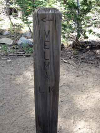
South TYT-PCT Middle Velma Lake |
Miles & Elevations |
Miles & Elevations INDEX |
Lake Tahoe Basin Management Unit PERMITS |
All forest-wilderness PERMITS |
Four Trails
One "T" Trail Junction
Pacific Crest, Tahoe to Yosemite, Desolation, and Tahoe Rim Trails
The
11.5 Miles South from Meeks Bay Trailhead 17.21 Miles South to Echo Lake Trailhead
Now It's a Triple-Trail TYT-PCT-TRT This State of Affairs continues from this trail junction hiking for 28.3 miles to our South until we reach Meiss Cabin, where the counter-clockwise Tahoe Rim Trail backpacker breaks off from the TYT-PCT to turn Northeast up into the Carson Range from the Meiss Cabin trail junction, which also leads to Round Lake. From that point the counter-clockwise Tahoe Rim Trail backpacker will be moving North up along the Crest of the Carson Range wrapping around the East Shore of Lake Tahoe.
High Sierra Geology & Tahoe Basin Geological Links
PCT-TYT The TYT & PCT split up exiting the Tahoe Basin, or shortly thereafter, at Carson Pass. The TYT and PCT will rejoin again in the top of Jack Main Canyon after hiking 134 miles to the South along the route of the TYT or 121 on the PCT down to where they both rejoin shortly after entering the North Yosemite Backcountry, but from their completely different directions.
TYT-PCT-TRT Hiking 2.62 miles South off of Phipps Pass which puts us a total of 11.5 miles South of our starting point out of Meeks Bay Trailhead we find where the Tahoe to Yosemite and Desolation Trails intersect with the combined North-South routes of the Pacific Crest and Tahoe Rim Trails. Here begins a run of four "named" routes, being the TYT, PCT, TRT, and Desolation Trails. The Desolation Trail ends 16.3 miles South at Lower Echo Lake, the Southbound (counter-clockwise)Tahoe Rim Trail turns Northeast 27.4 miles South at Meiss Cabin, and the Pacific Crest and Tahoe to Yosemite Trails break into separate routes 28.92 miles to the South of our position while exiting the Lake Tahoe Basin through the Carson Gap. At this TYT-PCT-TRT trail junction below Phipps Pass the Southbound hiker on the Tahoe to Yosemite Trail takes a Left to continue South on the TYT.
Meeks Bay to Echo Summit
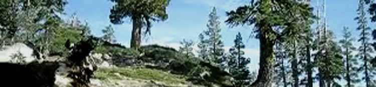
The Long Trails South Turning South here we are not just hiking on a whole mess of (four) "named" trails South through Desolation Wilderness, but we have joined the main High Sierra trail that spans the length of the Sierra Nevada Mountain Crest from Lake Tahoe to Mount Whitney, the Pacific Crest Trail. More important than the particular names of the trails is the fact that we have now arrived at the main North-South trail route running along whole length of the Sierra Crest between Lake Tahoe and Mount Whitney. The main route is the PCT, sharing parts of its route with the TYT up here in the Northern Sierra, and parts of its route down South with the John Muir Trail South of Tuolumne Meadows. Along the way the TYT and JMT routes vary significantly from the PCT. We will also find other alternative routes along the way, such as the Tungsten Road, Fish Canyon, and The High Sierra Route offer real variety.
Pacific Crest Trail The overall main route, measured by the overall number of annual long-distance hikers, is the Pacific Crest Trail, at least during late Spring and early Summer when the main body of PCT hikers come through. After the PCTers pass through the PCT mostly hosts section and local hikers. The timing of the annual passage of Pacific Crest Trail hikers through every part of the High Sierra depends on the timing of each hiking season's particular transition from Spring to Summer conditions, specifically when the trails and especially the high mountain passes are free from snow. I call the Pacific Crest Trail "The Super-Highway of Trails" because of these annual periods of very high-volume long distance backpacker traffic, and also because the Pacific Crest Trail's trail bed is so deeply cut into the terrain. If the PCT is the Superhighway of Trails, then the Desolation Wilderness is Los Angeles during the evening commute, constantly jammed full of backpacker traffic. This place is a zoo during mid-Summer. This high traffic means that all of the Desolation Wilderness trails shared with the route of the PCT are cut deeply into the terrain by the huge volume of hikers and backpackers here added to the massive annual pack the PCT now produces.
Entering the Heart of the Desolation Wilderness Desolation Wilderness is still full of backpackers long after the annual flood of Pacific Crest Trail hikers have hiked far to the North. |
Section Hiking, Loops, and Short Trips Two Cars-Two Trailheads-or a hitch This trail junction leads from the Northernmost trailhead in the Desolation Wilderness, the Meek Bay Trailhead. Thus if we are hiking the length of the Desolation Wilderness as a 28.71 mile section from Meeks Bay to the Lower Echo Lake Trailhead, or visa versa. We don't have to hike the whole length of the Desolation Wilderness. To the South of us we have 3 trail junctions that can be used to hike to potential end points for hiking trips out of Meeks Bay to the first two trailheads along South of Meeks Bay along Highway 89 at about 17 total miles trailhead-to-trailhead hiking South from our Meeks Bay Trailhead. South of Middle Velma Lake from the Bayview Trail Junction we can hike 3.85 miles over Maggies Peak to Eagle Falls Trailhead or 3.81 miles to Bayview Camp Trailhead. A bit further South we can also hook up with this same trail to Eagle Falls and Bayview Camp from the trail junction between Fontanillis and Dicks Lake. From the South side of Dicks Pass near Gilmore Lake we can hike West over Mount Tallac to the West side of Fallen Leaf Lake. These hikes from Meeks Bay on Highway 89 to Eagle Falls, Bayview Camp, and Fallen Leaf Lake on Highway 89 each represents excellent routes exploring Desolation Wilderness on shorter hikes than the Meeks Bay to Echo Lakes hike across the length of Desolation Wilderness.
Forest Service offers this 13 page PDF about
All
|
Junction
with the
Pacific Crest Trail
and
Tahoe Rim Trail
Southbound on the Tahoe to Yosemite Trail
 |
 |
||||
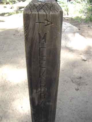
| Turn Left hiking out of Meeks Bay to continue Southbound on the Pacific Crest & Tahoe to Yosemite Trails towards Velma Lakes. | Back: North on the Desolation Trail back to our starting trail head at Meeks Bay. | ||||
PCT-TYT-TRT
|
|||||
 |
|||||
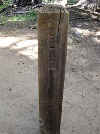
A right turn coming out of Meeks Bay would bring us Northbound on the Pacific Crest Trail: We go South on the TYT! But, you can see that heading North on the PCT also brings us to the General Creek Trail, which loops back to Lake Genevieve. These two maps cover North Desolation Wilderness:
You can see bits of the unmaintained General Creek Trail route between the PCT and Lake Genevieve on the top of the 30 min North Desolation Wilderness map.
|
|||||
Southbound Backpackers hiking Southbound on the Pacific Crest and Tahoe Rim Trails encountering this junction will see it as a "T-Junction" branching off to their Left, Northeast by the compass. Southbound PCT-TRT hikers will continue South passing-bye the trail to Meeks Bay off to their Left and staying to their right as they continue hiking South. This junction is well-marked for the unfamiliar hiker in either direction. Southbound hikers on the Pacific Crest Trail or Tahoe Rim Trail routes who are heading towards Meeks Bay to bail out or find resupply will take a hard-Left at this trail junction, leading them up to Phipps Pass. This route to Meeks Bay offers the quickest route out of the wilderness from this position, though we have to climb Phipps Pass. The easiest route would be longer, Continuing South to the Camper Flat-Bayview trail junction and finding out way out to the Northeast to Bayview Trailhead. Though not the most direct, the way to Bayview is most downhill route out of the wilderness. That would count for wounded and weakened hikers on the TRT, PCT, and those trying to figure out the terrain to put together a very nice backpacking loop around the North Desolation Wilderness. |
A video of the terrain heading South on the Pacific Crest and Tahoe to Yosemite Trails just South of this Trail Junction.
Duration 1:13 minutes.
Desolation WildernessMeeks Bay Pacific Crest Trail Elevation
Mileage
Mileage |
Soft Trail We follow a nice soft forest trail down to Middle Velma Lake through a mature lodge pole pine forest. I'm always talking about the trail surface because this will reflect the amount of impact our feet, knees, hips, and heck, our whole body are going to have to absorb through any particular part of the trail. Impact is cumulative. One of the trail stresses we must be able to neutralize and recover from every evening in camp are the physical stresses of constant impacts. The constant shocks of feet on granite is very different than the shock produced crossing soft forest trail. This small difference in the nature of the trail surface is ultimately going to translate into how we are going to feel later in the day, later in the week, and further on down the trail in a couple of weeks. Slowing down on hard surfaces to minimize impact is offset by speeding up on soft terrain where impact is minimized. These physical stresses will build up, if we let them. |
North TYT: S. Side, Phipps Pass South TYT-PCT-TRT: Middle Velma Lake
Desolation Trail |
||
Southbound off Phipps Pass the first trail junction we encounter intersects with the Pacific Crest and Tahoe to Yosemite Trails. If we are hiking South on the Tahoe to Yosemite Trail we turn Left to continue South towards Middle Velma Lake and the High Sierras beyond. If we are heading North on the Pacific Crest and Tahoe Rim Trails we turn Right at this junction.
Next page South |
Backpacking Trail Guide |
 |
Backpacking Trail Guide |
Backpacker ForumsGeneral Postings Backpacking Topics
Have you hiked the Pacific Crest Trail through the Desolation Wilderness?Add your experiences, comments, or pictures about rolling through this trail junction:Section
|
North TYT: S. Side, Phipps Pass South TYT-PCT-TRT: Middle Velma Lake
Trailhead
Contact
Alex Wierbinski

Backpacking Lake Tahoe to Mount Whitney
Your guide to the High Sierra Crest, including the Tahoe to Yosemite, Pacific Crest, and John Muir Trails
