

The Trails
Guide
Maps
Miles/Ele
Permits
Resupply
Forum
Current Weather Conditions
Weather Notes
Northern High Sierras
Central High Sierras
Southern High Sierras
Gear
Gear List
Gettin Started
Layering
Discussion
Testing yourself and your gear
Gear Reviews
Hiking
Schneider's Camp trail junction
Backpacking to Schneider's Camp trail junction South from Echo Summit to Carson Pass, the Meiss Country Roadless Area
Languages
Languages
Trail Arts
The art of walking
Physical Preperation
Trail Skills
The trail
Off the trail
Scrambling
Maps
Navigation
Camp skills
Food
Resupply
Food
Other
Photo Catagories
Trail Stories
Trail Culture
News and Science
Links
Groups
Books
Terms and Conditions of Use
The Trail South
over
Little Round Top to Highway 88
| The Schneider Cow Camp Junction |
||||
 |
||||
The trail Southwest to Caples Lake over Little Round Top is located 5.61 miles South of Echo Summit along the Tahoe to Yosemite Trail. Our continuing Southbound route along the Tahoe to Yosemite Trail brings us straight through this junction. A Right turn followed by 4.96 miles of hiking brings us over /around the North Flank of Little Round Top to Schneider Camp, which sits above Caples Lake. The 30 minute map below-Right details this route from the Tahoe Basin over to Schneider Cow Camp and the dirt road from there to Highway 88 near Caples Lake.
|
Information
Meiss Country Roadless AreaEcho Summit to Carson GapAt The
|
Video Playlist |
The South Upper Truckee River Drainage
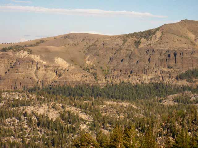
View Northeast across Christmas Valley
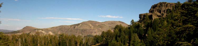
At the Schneiders Cow Camp trail junction we are still under thick forest cover. As we hike South the forest thins and ends. We find ourselves in a couple of positions where we get great views to the Northeast, East and Southeast. These positions look out over Christmas Valley, where a great trailhead starts the trail climbing up to Meiss Cabin via Dardanelles and Round Lakes. The upper part of this trail is also the segment of the Tahoe Rim Trail from Meiss Meadow to the Big Meadow trail junction to the Big Meadow Trailhead on Highway 89. In the image below there are two year round rivers flowing. The nearer is the South Upper Truckee, draining the West side of the valley, and the distant river is its main tributary, draining the East side of Christmas Valley below Meiss Meadow, including Dardanelles and Round Lakes. The South Upper Truckee and its main tributary merge as they flow North towards Lake Tahoe just above where their down mountain flow mellows where the river enters the flat terrain and subsequent meadows in the lower reaches of Christmas Valley. Hiking South (Left to Right in the image below) from the Meyers Trailhead we see that the South Upper Truckee splits into two branches, which wrap around the low white granite ridge rising out of the middle of the image below. The high point of that ridge is marked as Peak 7700 on this map. The main body of the South Upper Truckee River drains the West side of the Canyon, between our position and the granite ridge capped by Peak 7700. The other, unnamed tributary runs down the Eastern side, the far side of the granite ridge capped by Peak 7700 and the red volcanic canyon wall beyond. The trail South climbing up from the South Upper Truckee Trailhead in Meyers to Round Lake runs on the far side of the low granite ridge in the middle of the image below, following the course of the unnamed South Upper Truckee tributary up to Round Top Lake, and then up to Meiss Meadow. Check out the maps to understand this "wishbone" layout of the South Upper Truckee River and its tributary flowing down from Meiss Meadow to Meyers. Looking into Upper Christmas Valley |
 |
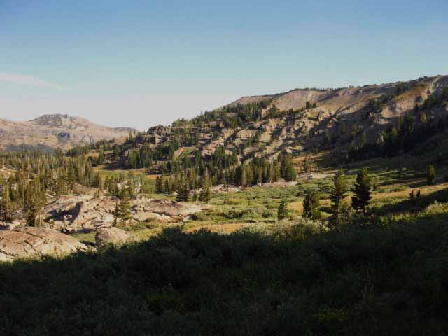
Hiking South past Schneiders Junction we once again emerge from the forest and have expansive views to the Northeast across Christmas Valley. Note Freel Peak in the distant far left of frame. The next picture below is also a perspective looking Northeast across Christmas Valley, but from further South down along our trail following the bending arc of the Tahoe Basin. |
North: Sayles Canyon, Bryan Meadow Junction South: Schneider's to Showers Lake Junction
Freel Peak and Jobs Sister
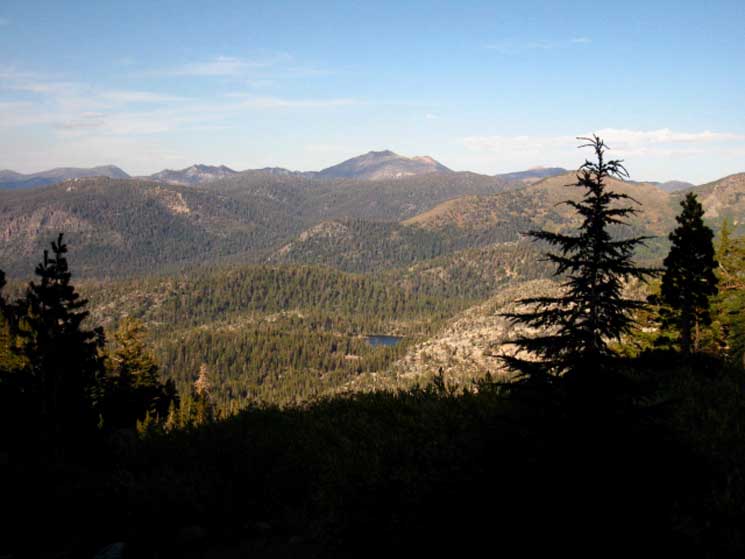 |
Hiking further South we'll find this alignment of Dardanelles Lake and the tallest peaks in the Tahoe Basin from the overlooks off the North shore of Showers Lake. Freel Peak and Jobs Sister looking across Dardanelles Lake, to our Northeast. |
View East Across Christmas Valley
 |
||
Close up of Christmas Valley laying between us and the Southern end of the Carson Range. Round Lake is between the ridge running across the center of the image above and the distant strip of forest, while Meiss Meadow is out of the frame of the image to the South, up to the Right. The Tahoe Rim Trail junction to Big Meadow is about a half-mile out of the Left edge of the image.
The route of the trail coming South, up from the South Upper Truckee Trailhead in Meyers crosses through that most distant strip of forest nestled-in under the volcanic cliffs along the West flank of the Carson Range. This route up through Christmas Valley from the South Upper Trailhead in Meyers joins with our trail at the Meiss Cabin. That trail is the Tahoe Rim Trail. Swinging our view further to the Right, to the Southeast by the compass, we get a view of the Southern end of the Lake Tahoe Basin. |
North: Sayles Canyon, Bryan Meadow Junction South: Schneider's to Showers Lake Junction
Hiking South
to the
Southernmost Corner
of the
Tahoe Basin
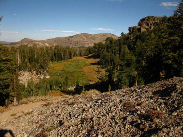
View to the Southeast down the trail. The terrain has changed to Our South. We can see that a thin shelf of broken meadows wrapping around the base of the Sierra Crest. The down-mountain side of the tilting meadows have broken fingers of Forest making their final push climbing up into the meadow fringes. This is a lot easier terrain than we've been hiking. |
 |
Forest opens into broken meadow and some heavy brush South of the Schneider Cow Camp trail junction. From Bryan Meadow to Schneider junction we've been on a line tracing out the actual line of the Sierra Crest. This shelf extends to the South end of the Tahoe Basin, with Showers Lake on its edge about a half-mile ahead, a bit off to our Left, while Meiss Meadow makes up the bottom end of the shelf about 2 miles further Southeast. Red Lake Peak is visible in the furthest distant beyond the bottom of the descending ridge-arm. Red Lake Peak marks the Southeastern-most corner of the Lake Tahoe Basin and the Southern end of the Carson Range. We will exit the Tahoe Basin through a gap in the ridgeline of the Tahoe Rim on the near Western Flank of Red Lake Peak that I call Carson Gap. We have easy fairly hiking from our current position over the next couple of miles of rolling terrain. South of Showers Lake we descend about 200 feet of elevation to begin climbing into Meiss Meadow. Of the 5.2 total miles from our position here to Carson Pass the most difficult segment is the intermediate-minus difficulty 400 foot climb from the South end of Meiss Meadow at 8400 feet of elevation up to the 8800 foot Carson Gap, our exit point from the Lake Tahoe Basin. Passing through the Carson Gap exiting the Tahoe Basin is the next highpoint along our route. This last of bit of terrain ahead of us in the Tahoe Basin is much different than the last six miles of terrain we crossed hiking South from Echo Summit, which was very different from the terrain we experienced hiking the thirty miles across Desolation Wilderness. |
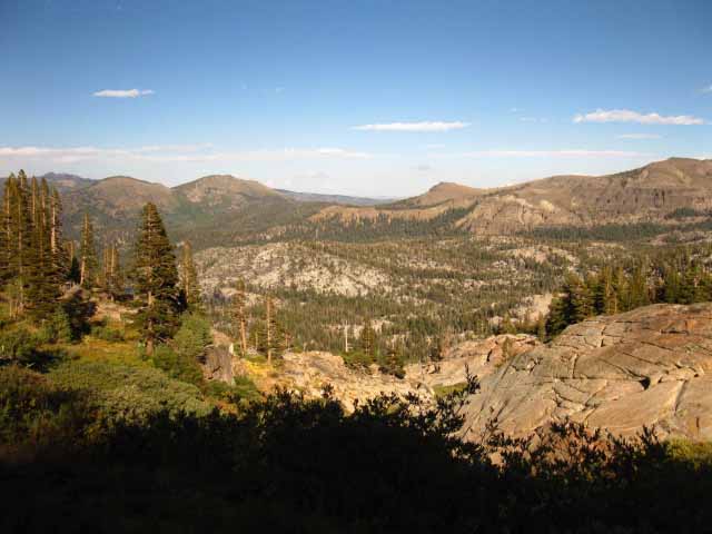
Final approach to Showers Lake, with stimulating views further East. We drop down into the ravine, then bend Left, to the North to wind our way around the granite outcropping delimiting the West Shore of Showers Lake, and the East side of the ravine, wrapping around its lower section to the check dam and campsites beyond. The highest peak is Stevens Peak on the furthest Right, with a subordinate peak,Peak 9708 to its Left. The peak in the further distance on the furthest Left is Peak 9211. |
 |
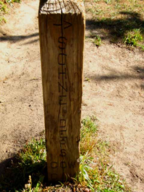
Hiking Southbound, almost to the jog in the trail to Showers Lake. Trail Modification Yes, there is still a faint trail across the terrain there, its beginning marked by a post where we turn down the ravine, but the Lake Tahoe Basin Management Unit's Trails have done their best to direct the majority of hikers around the North shore of Showers Lake. This section of trail has changed significantly from the route as depicted on the USGS maps, as are so many trails in the Meiss Country Roadless Area. Another big change that comes to mind is the major rerouting of the lower section of the trail from the South Upper Truckee to Round Lake. The legality of bikes on that trail necessitated a serious re routing to mitigate the rapid damage wrought by bike traffic. |
North: Sayles Canyon, Bryan Meadow Junction South: Schneider's to Showers Lake Junction
Schneiders Camp Junction |
We have a last bit of deep forest trail South from the Schneiders Cow Camp Junction. Dense forest almost instantly transitions into expansive views sweeping the terrain from Northeast to Southwest, as our trail descends into what we can see is a relatively flat shelf wedged into the descending mountainside. Showers Lake sits on the widest part of this "mountain shelf." Running in the Sun My point here is that PCT hikers are entering an extended length of exposed travel through terrain noticeably drier than we've experienced since departing Meeks Bay Trailhead. And the terrain we covered so far is pretty dry. Tahoe to Yosemite Trail WATER Drought conditions are drying out the ponds, and even bringing lakes down to a level that I don't want to drink out of very early in the Summer. Thus water availability is an important consideration planning for our upcoming potentially 12.76 mile long section of trail without water from the point where the small South Upper Truckee River gushes across our trail in Meiss Meadow down to Tamarack Lake along the Pacific Crest Trail route, and maybe even a bit further South than that. If it's a dry year, it may be possible that the last water we can get will be in Meiss Meadow, and the next potential water source could be as far South as beyond the Blue Lakes Road at Tamarack Lake. Maybe even further. Tamarack Lake gets drained pretty low during dry years, and we've seen lots of dry years when the water in it was ugly during the past couple of decades. Here's the Scenario We Southbound hikers can question the Northbound backpackers we encounter about upcoming water conditions as we hike South, and if we are beginning our backpacking trip out of nearby trailheads we'll be relying on ranger reports about water availability from the Ranger District issuing our permit. We need to know the distance between potential watering spots, which in turn determines how much water we must carry. If we cannot get accurate information from either source, and conditions look very dry, we have to assume that we will have to cross at least 12.76 miles without water from Meiss Meadow to Tamarack Lake. This is a good place to start asking Northbound hikers if they crossed the PCT terrain we are hiking into. If so, they will be able to give us good information. On the way South from Meiss Meadow we may be able to properly adjust how much water we are carrying based on information we get from the cool volunteers at the Carson Pass Cabin. Though they have no water source at Carson Pass, they might have the freshest information about water resources down the trail. Hiking South Dry Summer-Fall Conditions South Upper Truckee in Meiss Meadow Carson Gap Pond Carson Pass has no water source. Frog Pond dried up. Forestdale Creek not running at trail, ponds dry. (NOTE: Water status bad? We can walk the half mile over to Lost Lakes hiking South off Forestdale Divide... and it's a sweet place for lunch or a break.) No water across APPROCAHING WATER SOURCES Tamarack Lake is the first in a series of small lakes and reservoirs that should be refreshing. Creek on the North Side of Raymond Peak Tahoe Rim Trail The TRT turns Northeast from Meiss Cabin to hike down through the terrain we observed above, down the East side of Christmas Valley to break off at the Big Meadow trail junction towards Freel Peak on its way North along the crestline of the Carson Range above the East Shore of Lake Tahoe. Our hike South on these three unified Pacific Crest, Tahoe to Yosemite, and Tahoe Rim Trails will continue South from here past Showers Lake to Meiss Cabin. South of that point only the TYT and PCT continue South to exit the Tahoe Basin together through the Carson Gap. Just South of the Carson Gap we come to the first of three junctions where the Tahoe to Yosemite Trail breaks off to the Southwest from the main Pacific Crest Trail route. Our Current Position We have hiked out of the edge of dense forest through some open terrain, and despite our overall loss of elevation, we will continue rolling up and down, but more down than up, until we begin a slow climb as we enter the North side of Meiss Meadow. Note on the map how the country opens up shortly after the Schneiders Cow Camp junction. The trail before us falls away into broken meadow punctuated by stands of brush and trees. These broken meadow bits expand, and ultimately grow into the grand crescent-shaped high elevation expanse of Meiss Meadow, almost the last bit of the Tahoe Basin we walk across on our way South to the Carson Gap. 7.5 min hiking Topo Map 30 min hiking Topo Map Next page South |
Backpacking Trail Guide North Sayles Canyon, Bryan Meadow Junction |
 |
Backpacking Trail Guide South |
Backpacker ForumsGeneral Sierra Nevada hiking thoughts to relate? Post 'em on
On the Forum you can browse trail locations and add your experiences, comments, questions (or pictures and videos) about hiking South out of the Echo Summit Trail Head. General comments about the Echo Summit to Carson Pass section of the High Sierra trails, or this particular location: Section
|
North: Sayles Canyon, Bryan Meadow Junction South: Schneider's to Showers Lake Junction
Trailhead
Contact
Alex Wierbinski

Backpacking Lake Tahoe to Mount Whitney
Your guide to the High Sierra Crest, including the Tahoe to Yosemite, Pacific Crest, and John Muir Trails
