


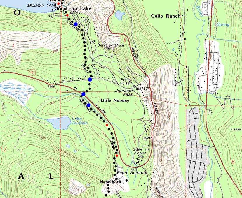
Echo Lake Through Echo Summit hiking map
The Tahoe to Yosemite and Pacific Crest Trails
7.5 minute Backpacking Topo Map Departing Desolation Wilderness and entering the Meiss Country Roadless Area

| MAP Index Tahoe to Alpine maps |
NORTH 30 Min Map Phipps Pass to Upper Velma Lake |
SOUTH |
NORTH 7.5 min map North Echo Lake |
Next 7.5 min map SOUTH Echo Summit to Carson Pass |
Full Echo Lake 7.5 Map |
Click red map dots for links to Guide Pages and black map dots for Detailed Maps |
Trail Guide Echo Lake |
all pages | miles and elevations |
||
| Or Echo Summit Trailhead |
Topo Map
Echo Lake Trailhead to Echo Summit Trailhead
2 miles
| Click BLACK DOTS & MAP for Detailed Maps |
Click RED DOTS for Trail Guide Information |
| Map North Southern Desolation 30 min |
Map South Echo Summit to Carson Pass 30 min |
Map South Echo Summit to Carson Pass 7.5 min |
|
| Map North Southern Desolation 30 min |
Map South Echo Summit to Carson Pass 30 min |
Map South Echo Summit to Carson Pass 7.5 min |
| Location | |||||
Main Features The Desolation Wilderness boundary is actually North of Upper Echo Lake. Thus the houses around the lake and here between the South end of Desolation Wilderness and the North end of the Meiss Country Roadless Area. The Lower Echo Lake Trailhead is the Southern access point to Desolation Wilderness and the North-to-South exit point of hikers on the PCT, TYT, and TRT. The vacation homes around the lake indicates that is not wilderness. It is interesting when houses are built right up to the Wilderness Boundary... We will not see great granite formations like those in Desolation again until we drop into Summit City Creek behind Round Top, if we are following the Tahoe to Yosemite Trail hiking South. In any case, two miles separate the trailhead at Lower Echo Lake from the Echo Summit Trailhead. The first mile of the trail brings us through a neighborhood of National Forest and full time residences to cross Highway 50 just East of Little Norway. The next mile of trail South parallels Highway 50 East, up a fairly gentle grade to Echo Summit. Echo Summit is a trail head option for Southbound backpackers on the long trails South as well as an entrance into the Meiss Country Roadless Area for short backpacking trips. Beginning our trip South to Yosemite from Echo Summit trims 32 miles off of the length of our Tahoe to Yosemite Trail backpacking trip compared to beginning at the Meeks Bay trail head. Alternative and Standard Resupply All at Once, or One Piece at at Time We can knock this thing out in sections.
|
Mapping Information |
|
Miles and Elevations Meeks Bay to Echo Summit Miles and Elevations Echo Lake Trailhead to Echo Summit Trailhead Meeks Bay trailhead to Echo Lake trailhead Echo Summit to Carson Pass
Tahoe to Alpine Trail Guide
Meeks Bay
Physical locationEcho Lake and the Echo Summit trailheads are bisected by Highway 50 just West of Echo Summit. |
USGS TOPO Map Information Map
Compass Offset
scale Contours Backpacking Permitting Authority Lake Tahoe Basin Management Unit Lake Tahoe Basin Management Unit National Forest LTBMU Wilderness Areas Desolation Wilderness & Meiss, TahoeWhitney Desolation Wilderness, the feds. Meiss Country Roadless Area, the feds. |
7.5 map North: Echo Lake 7.5 Map 7.5 map South: Echo Summit to Carson Pass
| Elevations | More Information | ||
Lake Tahoe: 6226 feet Echo Lake: 7414 feet Echo Summit: 7377 |
Trail Guide Section Trail Guide, Section Google Map |
||
Map Credit |
U.S. Geological Survey, Department of the Interior: The USGS Use search term "Meeks Bay," and "Address," as search type to locate this USGS map. USGS Topographic Maps |