The Trails
Guide
Maps
Miles/Ele
Permits
Resupply
Forum
Current Weather Conditions
Weather Notes
Northern High Sierras
Central High Sierras
Southern High Sierras
Gear
Gear List
Gettin Started
Layering
Discussion
Testing yourself and your gear
Gear Reviews
Backpacking
Meiss Country Roadless Area
Meyers to Round Lake
Four-Season Hiking and Backpacking into Meiss Country Roadless Area
Languages
Languages
Trail Arts
The art of walking
Physical Preperation
Trail Skills
The trail
Off the trail
Scrambling
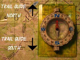
Maps
Navigation
Camp skills
Food
Resupply
Food
Other
Photo Catagories
Trail Stories
Trail Culture
News and Science
Links
Groups
Books
Terms and Conditions of Use
Lower Trail
across
All Seasons
| 15 min Hiking Map Meiss Country Roadless Area |
30 min Hiking Map Echo Summit to Round Top Lake |
| On this page |
||||||||||||||||||
Video
Summer
see the previous page for directions to the trailhead Dense Forests
Spring Delights Snowplants and Rain
Weather, Gear, and the Seasons
MAP
MILES AND ELEVATIONS
All Weather |
South Lake Tahoe
Local Resources |
|||||||||||||||||
| > Forum < | ||||||||||||||||||
All backpackers can post text comments about this page, and each of the following segments of trail through the comments links on all the trail guide pages. Your contributions are welcome to supplement this section of the trail Guide from Meyers to Meiss Cabin, or any segment along our trail from Tahoe to Whitney. Check out all the Tahoe to Whitney .org Share what you see out here. |
||||||||||||||||||
Hiking South
into the
Forest
March 18, 2010
Video
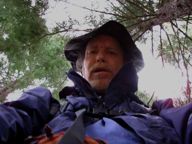
Winter Trailhead
| Backpacking our route across the Winter-Spring transition. | ||
See the full list of Videos from this
|
South Upper Truckee Trailhead The South Upper Truckee trailhead is located where the River coming South down the mountain flattens out to cross Christmas Valley's lower meadows. The new trail route (2009) avoids the center of the South end this flat near the river and immediately begins gently climbing into the forests along the Eastern flank of the valley South of the trailhead. The trail starts veering Southeast to traverse up the mountain flank rising to our Left. I've marked the new trailhead location on the map. The trailhead as originally laid out on the map has been changed. |
Summer Trailhead
| A very brief flat, before the four mile climb to Round Lake, our traditional first night campsite. |
 |
| Very Brief flat before the 1560 foot Climb to Round Lake begins in earnest. |
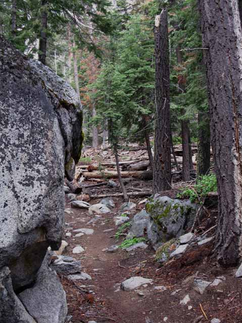
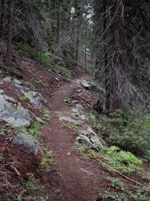
Sweet Forest and Granite
| Deep forest rising out of the Tahoe Basin. |
 |
| Deep Forest past trailhead. |
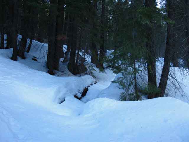
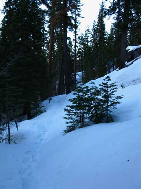
Winter
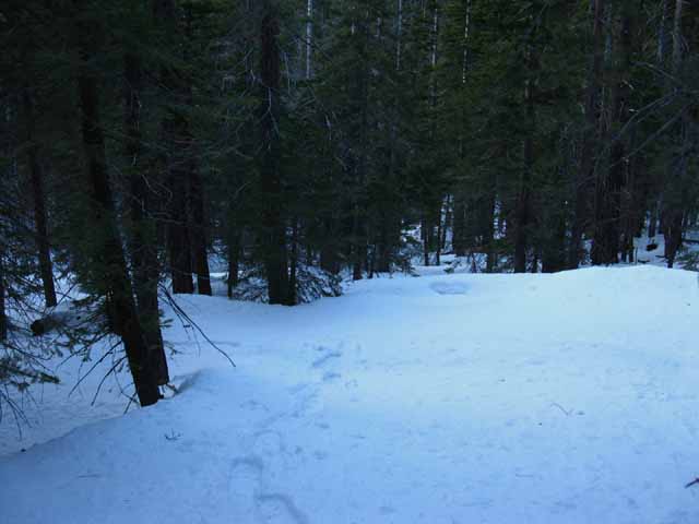 |
Hiking South from South Upper Truckee Trailhead looking back at footsteps through the forest.. |
Where we are
South Upper Truckee Road TrailheadMeiss Country Roadless AreaGently rising forest just South of the trailheadElevation Mileage After this brief gentle climb, the trail steepens. |
Heavy Forest Floor Litter
| Forest Floor litter ready to bust into flames. |
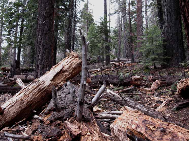 |
This beautiful forest is in serious danger of burning up (again) due to the dense accumulation of dead and dried forest floor litter. This is the face and fate created by decades of fire suppression sponsoring and supporting policies of iresponsible growth. The incredible scale of this growth has changed the progression of seasons, which is compounding all the worse implications of our irresponsible behavior. The dry seasons we induced will burn the fuel we've compiled. What will grow back will be suited from drier climates. The Sierra is undergoing a radical transformation. |
Controlled BurnI understand that The LTBMU is going to try to controlled-burn this forest litter in an attempt to prevent a disastrous fire. (2011) Yikes! This is a classic "damned if you do, damned if you don't" situation. A "controlled" burn here could easily get out of control. I just hope they do it in Spring or Fall, while it is still moist. Otherwise keeping any burn controlled in here will be a real handful. Deep forest floor liter, incredible dry conditions, and lots of dead standing snags will make keeping controlled burns controlled in this narrow drainage very difficult. |
 |
||
Winter above the trailhead Crossing snow presents challenges and advantages absent during Summer. For instance, a couple of nice segments of upcoming terrain are going to be much easier to cross over a more direct route that possible during Summer because snow has covered terrain that would be difficult to cross during Spring and Summertime. On the other hand, we will have to contend with obstacles not present on the maintained trails of Summertime. We will find great resistance crossing powder snow, greater resistance of each step through snow than across solid terrain, along with the challenges to observation and analysis that route finding through complex snowed-in terrain demands. All suck up more calories than conventional Summer hiking. Oh, and our Winter gear is a heck of a lot heavier than the Summer gear.
|
North: South Upper Truckee Trailhead South: Climbing Christmas Valley, Burnt Area
HUSHED SILENCE This forest trail is very quiet. Muffled, really. |
 |
The feeling of heavy quiet in this forest is a function of the dampening effect imparted by the density of the forest, the density of the forest floor litter, and the shape of the valley this all sits within. These combined factors create a "muffled" or "hushed" feel within this dense piece of forest. |
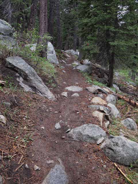
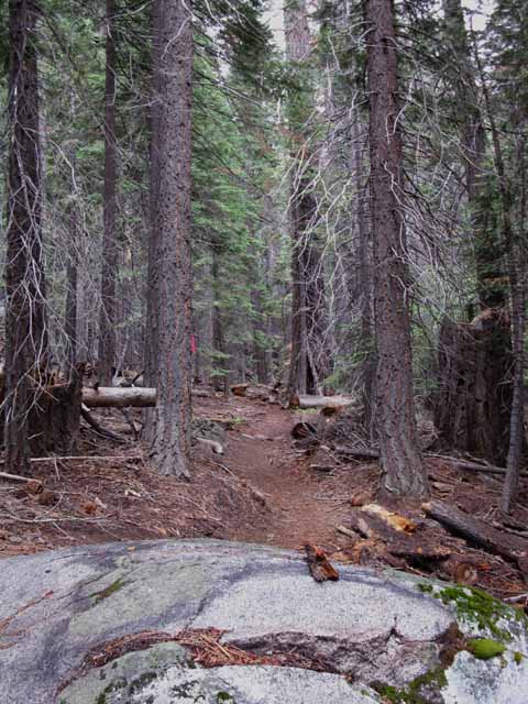
Sweet Trail
| The new trail. |
 |
It looks great, but the trail has been lengthened. It seems to me a set of switchbacks was installed across the original straight line of the trail from the trailhead South into the lower mouth of the tributairy up to just below the Burnt Flat. |
New Trail Note that this lower section of trail up to the burnt area has been significantly rerouted between 2007 and 2008, which has extended the length of the trail from the trailhead to Round Lake. I measure the distance between the South Upper Truckee Trailhead and Round Lake at 3.39 miles, as listed on the miles and elevations page. The 3.39 mile distance was measured before the switchbacks were installed. I figure the new total distance between the trailhead and Round Lake is around 4 miles. |
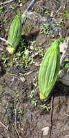
Early Spring Delights
Brand New Snowplants
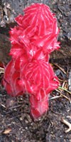
| Natural Fluorescence The Snowplant. |
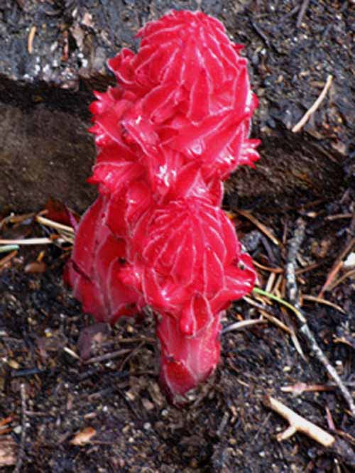 |
| Snowplants were bursting through the forest Floor everywhere, adding intense contrast to the dark shades and shadows in the dense forest. This image was taken in June, when a fantastic series of rainstorms was blowing through. The wetness of the recent thaw, combined with the rainstorms was creating ideal conditions for a widstread blooming of Snow Plants, which imparted a magical feel to the dripping wet "hushed" forest. This Snowplant is bursting out of the ground next to a fallen tree semi-submerged in the fully saturated forest floor litter. The Snowplants were long-gone when I came through again in July. Check out the Fungus Forum to post up entries about fungus, while you can leave comments on the Snowplant entry. Each part of each season has a character that's reflected by the plants, animals and insects. Snow Plants are a hard to miss part of the Spring Thaw. Living Things Snowplant references |
Spring Rains
Light rains, showers and fogs blessed my first day on the trail for a brief 5 night trip to Round Top Lake and back during early June of 2009. We've switched-out our heavy Winter Gear for lighter Spring-Fall gear, taken out a couple of layers of insulation from our Winter layers, and retired the heavy Winter Boots. For backpacking trips earlier in the season we've packed the Full Winter Gear Kit. Our destination for this snow trip through the Meiss Country will bring us out of, and back into the Tahoe Basin. It was 54° at 3 pm on June 7 in Mists and Rains when I arrived, and 41° when I arrived at Round Lake after hiking the four miles and 1560 feet up from the South Upper Truckee Trailhead. |
 |
The earthy smell of the moist forest was refreshing. Previous years this early June rain would have been snow. Well, it will likely be snowing higher up, maybe. Nonetheless, the seasons have changed in the High Sierras. Winter begins later, if at all, and has much less snow. The snow that does fall is wetter, the average tempertures are higher, and earlier and earlier Spring Thaws are typical of the changes. I suggest seeing the Sierras now, before these changes in the character of the seasons completely alters the environment and the experience. |
June
|
July
|
WinterThe Tahoe Basin can experience a wide range of Temperatures during Winter. The key to a successful Winter trip is to gear yourself properly for the coldest temperatures possible during your trip's time frame. Though Winter has been getting shorter and warmer each year, the Sierra Nevada is prone to intense cold snaps and high winds. Don't get "suckered" into a dangerously under-equipped situation by the increasing periods of tame conditions. Neither during Winter or Spring. Cold snaps and blizzards will happen. To ascertain what's going on with the weather, check out this video. This High Sierra Weather Page has a wide range of tools to determine weather conditions and forecasts as well as snow depth and temp in specific locations up and down the Sierra Crest. Low single degree temps are common in the mountains around Lake Tahoe during Winter. I've seen low temps combined with high winds that bring the wind chill factor quite far below zero. Take a look at our |
 |
Working our way South-Southeast up the mountain, looking back to the North at our route edging up the flank of the mountain from the trailhead. |
North: South Upper Truckee Trailhead South: Climbing Christmas Valley, Burnt Area
Hiking South |
| A
brief but beautiful walk across a too-short flat section of heavily shaded dense forest marks the beginning of our Backpacking trip South out of the South Upper Truckee trailhead.
On our way to the trail head we've noticed the deepening quiet. Once we enter the forest its dampening effect seems to be magnified and reinforced by the shape of the valley, the thickness of the forest, and the dampening effect of deep forest floor liter. Quiet so intense you can hear it. But not silence. Though dense and dampening, we are still close to the bustle of South Lake Tahoe. But even here, right past the trailhead, the protective arms of the forest and the narrow aspect of valley instantly dampen the sounds of civilization. Shortly we will fill the void of disappearing civil noise with the sounds of our webbing stretching and cracking over the rhythem of our panting as our lungs and legs strain to get enough oxygen to bring us up to Round Lake. 7.5 Topo Hiking Map 30 min Topo Hiking Map Next page South |
Backpacking Trail Guide North |
 |
Backpacking Trail Guide South |
Backpacker ForumsGeneral Sierra Nevada hiking thoughts to relate?Post 'em on
On the Forum you can browse trail locations and add your experiences, comments, questions (& pictures and videos if you Register...) about hiking South out of the Echo Summit Trail Head. General comments about the South Upper Truckee to Carson Gap section of the High Sierra trails, or this particular location: Section
|
North: South Upper Truckee Trailhead South: Climbing Christmas Valley, Burnt Area
Trailhead
Contact
Alex Wierbinski

Backpacking Lake Tahoe to Mount Whitney
Your guide to the High Sierra Crest, including the Tahoe to Yosemite, Pacific Crest, and John Muir Trails
