

High Sierra
Backpacking
Trail Guide
Forums
Sierra
Weather
WeatherNotes Northern
Sierra Weather
Gear
Backpacking Desolation Wilderness
through the
Second Trail Junction
South
of
Middle Velma Lake
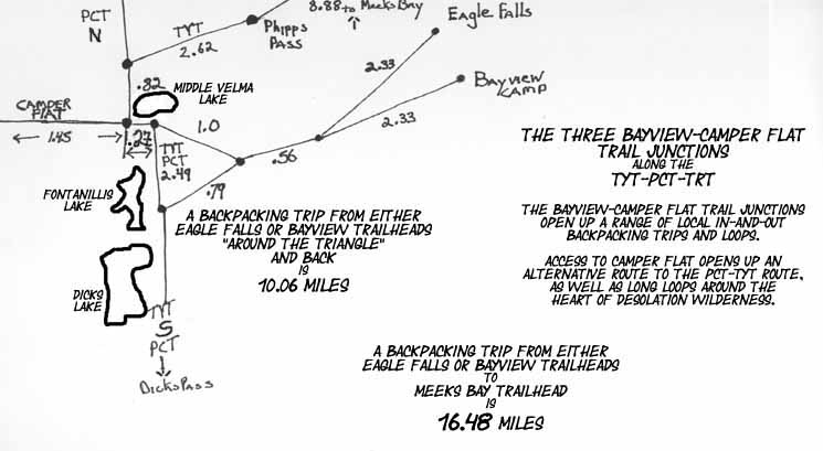
Hiking the Tahoe to Yosemite and Pacific Crest Trails past the 3 Camper Flat-Bayview Trail Junctions
Languages
Trail Skills
Mountain
Safety
Food
Planning
Trail Arts
More
Information
Social
| Trail Guide Section INDEX |
North |
South TYT-PCT Fontanillis Lake |
TRAIL Miles & Elevations |
Miles & Elevations INDEX |
Lake Tahoe Basin Management Unit PERMITS |
All forest-wilderness Permits |
Local Weather All Sierra Weather |
Lay of the Land
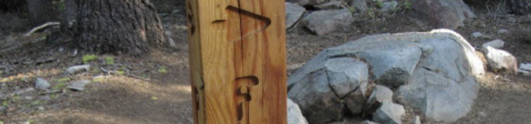
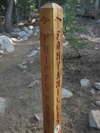
The arrow is pointing us to our Southbound Right, South along the marked PCT route towards Fontanillis Lake and Dicks Pass beyond, while we can also see the arrow pointing Northwest back up the PCT-TYT-TRT towards Phipps Pass, the way we came South on the Tahoe to Yosemite Trail. The trail in front of us to the Southeast continues East straight through this junction to end on Highway 89 along the Western shore of Lake Tahoe. Its track to the Northwest behind us continues to and past Middle Velma Lake on its way to Camper Flat in Rockbound Valley. The second trail junction to our East from this second Camper Flat-Bayview junction pictured above splits this single trail leading towards the West Shore of Lake Tahoe into two trails, one leading to the Northern Eagle Falls Trailhead and the other to the Bayview Camp Trailhead to its South along Highway 89. We will not see that, as we turn South here. Schematic Trail Map of Bayview and Eagle Falls Trailheads Hikers continuing South on the Tahoe to Yosemite Trail turn Right, South through this second Camper Flat-Bayview trail junction. LTBMU Forest Service Information TRAILHEADS
Links open in new tabs
Next Junction South Our Schematic Trail Map of North Desolation Wilderness shows its routing. The third and last junction to Lake Tahoe South of here is East of the gap separating the South Shore of Fontanillis Lake from the North Shore of Dicks Lake. It is there our trail turns East to climb from between the lakes to find this last trail junction tracking to our North sitting on the Western edge of a gap almost overlooking Lake Tahoe. First Junction This second junction pictured here, and the third Camper Flat-Bayview trail junction further South both give us access East to Highway 89 on the West Shore of Lake Tahoe through the Eagle Falls or Bayview Camp Trailheads, depending on our route preferences. Check out the map: Meeks Bay to Dicks Pass Local Access
Here's a warning from an informed local.
Long and Short Balance Scrambling an area following-up on interesting things we've seen while hiking through on long distance backpacking trips makes local trips complimentary to the long, filling in gaps in experience that long trips cannot fill. Legs Fresh, Lungs Clear, Lens Clean. Our short hikes get and keep us in the mountains, keep us in "mountain" conditioning, and allow us to explore terrain closely. Our longer hikes give us our grand context, and inform our future short trips and scrambles. There are no conditioning regimes that can run us to the level of fitness backpacking trails walk us up to. We've just got to keep a foot on the trail. These trails accessing North Desolation Wilderness are short, but they are steep and bring us deep. Punch Count Northbound backpackers on the Pacific Crest or clockwise Tahoe Rim Trail coming down from Dicks Pass will turn "Left, Left, Right" through these same three trail junctions. As easy as 1-2-3. Map and Miles
Meeks Bay to Echo Summit We Southbound Backpackers take a Right to continue South on the Tahoe to Yosemite and Pacific Crest Trails from this second, the middle Bayview-Camper Flat trail junction, in pursuit of our goal to continue South on the Tahoe to Yosemite Trail over Dicks Pass. Backpacker'sForums and Comments
|
Northeast Desolation Wilderness
Trail Schematic
 |
||||||||
Eagle Falls or Bayview Trailhead access to Middle Velma, Fontanillis, and Dicks Lakes along the combined route of the TYT-PCT-TRT. We see access 1.45 miles West to Camper Flat in Rockbound Valley. The map below-Left focuses on the route of the TYT-PCT along the three Bayview-Camper Flat trail junctions. The map below-Right expands on the detailed view to show the alternative route to the TYT-PCT we can hike through Rockbound Valley, and the remainder of our Southbound route through Central and South Desolation Wilderness.
The Desolation Wilderness map gives us our biggest picture of the Central Desolation Wilderness terrain. Camper Flat shows us that we need to build more awareness about the Western Flank of Desolation Wilderness and its trailheads. Desolation Wilderness Trips that climb into Desolation out of the tops of West Flank Forests have a different character than trips climbing from the deep blue Shores of Lake Tahoe. The Left of the two Federal links below from El Dorado National Forest list the West Flank Trailheads they administer, and the Right link maps their position in Desolation Wilderness hiking zones. Using these Federal resources in conjunction with the full Desolation Wilderness Map opens up the full potential of West Side Trailheads into Desolation Wilderness. Go explore yourself some Desolation Wilderness trails and terrain.
Full Desolation Wilderness Backpacking Map Though all permits for Desolation Wilderness are issued centrally through recreation.gov, both of the National Forests administering trailheads accessing Desolation Wilderness publish extensive rules and regulations covering Desolation Wilderness.
Fed links can be unreliable. Let me know when these links fail and I will track them down and hook them up again. |
Hiking Southbound
into the
Second
Bayview-Camper Flat Trail Junction
| Southbound Hiker Straight to Maggies Peak hiking East to Lake Tahoe or Right to Continue TYT-PCT-TRT South to Fontanillis Lake A Well- Marked Trail Junction |
||||||||||
 |
 |
|||||||||
| Hiking South on the Tahoe to Yosemite Trail we turn Right, South, towards Dicks Pass via Fontanillis Lake. | If we hike straight through this junction, we are hiking East on the Bayview-Camper Flat Trail. This is also known as the Velma Lakes Trail. |
|||||||||
The Lay of the Land Velma Lakes Trail Our TYT-PCT-TRT route shares the trail with this popular local route from Tahoe to Camper Flat through this segment of trail. Alternative Route The 30 minute North Desolation maps below shows this potential alternative route through Rockbound Valley in relation to the main TYT-PCT route.
Let's imagine coming in from Meeks Bay and turning West from the Northernmost Bayview-Camper Flat trail junction at Middle Velma Lake and hiking to Camper Flat in Rockbound Valley. From Rockbound Valley we hike South to the end of the valley over Mosquito Pass to the North Shore of Lake Aloha. From Lake Aloha we follow the Tahoe Yosemite Trail North back to this series of Bayview/Eagle Falls trail junctions. Or further North. We can hike East to Bayview Camp or Eagle Falls to end our loop, or we can hike North past Middle Velma Lake and stay on the TYT over Phipps Pass to Meek Bay. East from the Bayview Trail Junctions Phipps Pass to Heather Lake TWO ROUTES EAST Virtually all the water draining out of the basin feeding the Velma Lakes flows through this gorge and the gap at its base down into Emerald Bay. The trail to Bayview Camp entails a moderate climb over Maggies Peaks, followed by a moderate descent between our current position at the Second Bayview Trail Junction and its trailhead on Highway 89, while our other trail option to Eagle Falls descends steeply. In any case, both of these trails are a hard climb into Desolation Wilderness, with the route over Maggies Peaks from Bayview Camp being the easier way both in and out.
I'm just letting you long distance backpackers know where these trails go. Plus, these Eagle Falls and Bayview Trailheads are great entrances into the North Desolation Wilderness for short and medium distance backpacking loops around Desolation Wilderness, as well as a good emergency exit for fading/broken backpackers. Remember: Shit Happens. Be Ready. I have a saying. Well, I've lots of sayings. The one fitting this situation goes something like this; I always keep an eye on the emergency exits.
Mileage East Meeks Bay to Echo Summit Both of these trail routes East bend to the Northeast to navigate over or around Maggies Peak. The route to Eagle Falls turns North tracing out its route down along the curving Northwestern flank of Maggies Peaks. It finally drops down through the gap between the North Flank of Maggies Peaks and the South Flank of Peak 9195, where Eagle Creek drains the whole of this Velma Lake basin into Lake Tahoe through Eagle Falls. Remember when we were looking at this gorge and its gap Eagle Creek flows through down to Lake Tahoe through from the North side of Phipps Pass? We we observing the route of Eagle Creek through the terrain from up there, before we dropped down to Middle Velma Lake and this series of 3 trail junctions pointing East. The trail to the Bayview Camp Trailhead splits off East from the Eagle Falls Trail to cross over to Bayview Camp by climbing over the Maggies Peaks massif between the two main peaks. Though the Bayview Camp Trailhead is close to Eagle Falls, it is perched high up on the base of the Cascade Lake side of the ridge arm dividing it from Emerald Bay. Mileage South
|
||||||||||
Second |
Desolation WildernessMeeks Bay
|
North TYT: South of Middle Velma South TYT: Fontanillis Lake
Backpacking South |
||||
.27 of a mile South of the first Camper Flat/Bayview trail Junction is our next junction, the second of the three Bayview Trail junctions we encounter hiking South from Middle Velma Lake along the TYT-PCT route. Upper Velma Lake Phipps Pass to Heather Lake South on the TYT To the East If injured, exhausted, or out of food it is very good to know that the trail down to Eagle Falls is virtually all down-mountain, and makes a good in or out for rescue, or if you are not quite up to the rigors of long distance High Sierra Backpacking. To get your beak wet, so to speak. I've never come in to the main trail from either Eagle Falls or Bayview Camp. I drop down from Meeks Bay. I've studied the terrain and the maps, but I've always found myself looking at Desolation as the place the Tahoe to Yosemite Trail begins out of Meeks Bay Trailhead. Honestly, I started avoiding Desolation Wilderness years ago. I just could not accept so many people. I've gotten over that now. Now I expect the amount of people relative to the density, difficulty, and distance of any particular wilderness area to a major population center(s). We created it, now we have to live in what we created. If you've hiked either of these route into the Velma Lakes Basin I'm very interested in your impression of these trails, your pictures of the terrain, and your trail notes. I've told you what I've experienced, now it's your turn...
Next page South |
Backpacking North Trail Guide |
 |
Backpacking South Trail Guide |
Backpacker ForumsGeneral Postings Backpacking Topics
Are you familiar with the Bayview/Eagle Falls Trails?Add your experiences, comments, or pictures about this backpacking area between Middle Velma Lake and Dicks Pass.Section
|
North TYT: South of Middle Velma South TYT: Fontanillis Lake
Trailhead

Backpacking Lake Tahoe to Mount Whitney
Your guide to the High Sierra Crest, including the Tahoe to Yosemite, Pacific Crest, and John Muir Trails
