


Backpacking Weather Map
Southwestern
Lake Tahoe Region Weather Stations
Real Time Temperature, Wind, Humidity, Rain and Snow

| Sierra Weather | Lake Tahoe Weather Information | Northern Sierra Weather | Central Sierra Weather |
Southern Sierra Weather | Carson Pass Weather Map | Click map dots for links to Weather Stations | Trail Guide Echo Lake |
trail guide index | maps index |
Tahoe to Yosemite Trail
Trailhead
North Desolation Wilderness
Nearby
Backcountry
REAL TIME
Weather Reporting Stations
Desolation Wilderness and the Southwestern Tahoe Basin
The Tahoe to Yosemite, Pacific Crest, and Tahoe Rim Trails
Big
Red Dots
Designate & Link to Weather Stations
Black Dots
Link to Detailed Maps
Related Resources &Information
Terrain Overview |
All |
Lake Tahoe Regional NWS Weather Forecast Calendar
Click Map for Weather Stations & Detailed Maps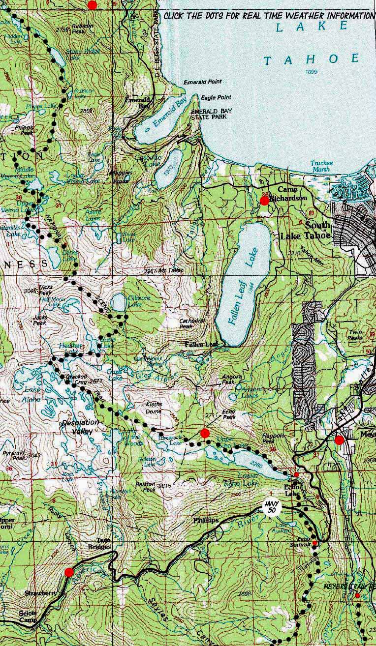
|
WEATHER MAP
SOUTH
Carson Pass Region Weather
| Basic Facts | Advanced High Sierra Backpacker Weather Resources |
The Sierra Crest is noted for having the capacity to produce four seasons of weather during a single Summer Day. Rain, snow, hail, fog, lightening, and a bit of sunshine can all happen in quick sequence. The High Sierras are noted for rapid changes in weather and temperature, and the sudden appearance of harsh weather trends. You may experience anything from intense heat to bitterly cold Summer snow storms. Or you may not. Long Distance Backpackers who were on the High Sierra Crest in early August of 2009 (and July of 2015) experienced just such a series of Summer Snow Storms. Temperatures dropped to the high teens and low twenties, snow and hail fell which partially obscured the trails, and all of those who entertained the misconception that the Sierras only have fine weather during the Summertime were bitterly disappointed. Luckily for the many backcountry travelers who were not properly prepared, those storms blew apart, rather than consolidated and deepened. (The 2015 storms had their way) Weather considerations should guide your gear selection.
|
Weather Preparations for Backcountry TravelAll Seasons1st:
|
| Map Credit |
U.S. Geological Survey The Use search term "Meeks Bay," and "Address," as search type to locate this USGS map. USGS Topographic |
Backpacker Forums
Have a great Sierra Nevada route or trip to
|