

High Sierra
Backpacking
Trail Guide
Forums
Sierra
Weather
WeatherNotes Northern
Sierra Weather
Gear
Backpacking
Southern Bayview Trail Junction
in the
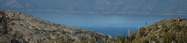
Desolation Wilderness
Hike the Bayview Trail junction out to Eagle Falls or Bayview Camp on Highway 89 to
Velma, Fontanillis, and Dicks Lakes
Languages
Trail Skills
Mountain
Safety
Food
Planning
Trail Arts
More
Information
Social
| Trail Guide Section INDEX |
North |
South TYT-PCT Hiking to Dicks Pass |
Miles & Elevations |
Miles & Elevations IDEX |
Lake Tahoe Basin Management Unit PERMITS |
All forest-wilderness PERMITS |
|
Fontanillis Lake
South
to the
Southernmost
Bayview Trail Junction
|
As we climb 120 feet while hiking the .65 of a mile from the South shore of Fontanillis Lake up to the third Bayview Trail junction, the Southernmost of the three Bayview Trail junctions, we will pass by the North end of Dicks Lake. Under it, really.
Meeks Bay Trailhead
BayView Trail Junction Bayview Trail Junction to Eagle Falls Trailhead: 3.68 miles. Bayview Trail Junction to Bayview Camp Trailhead: 3.68 miles.
Bayview Trail Junction South
Schematic Map NE to Lake Tahoe Trailheads
We won't see it, as the North shore of Dicks Lake sits above us, nestled into its upper bowl, and the rising terrain leading up to it is shrouded behind a thick swath of forest off to our right, our South as we turn East on our way up to the Bayview Trail junction from the Southern end of Fontanillis Lake.
Meeks Bay to Echo Summit
We can tell when we're close to the North shore of Dicks Lake as there are many little well-used paths heading off to our right as the trail turns East, to our left from the South Shore of Fontanillis Lake, to begin the easy climb up to the Third Bayview Trail junction. These many "little" informal paths over to Dicks Lake break off from the Right side of the Southbound backpacker's trail up to the Bayview Trail junction, and trails down to Dicks Lake branch off for a short distance South past the Bayview Trail junction along the Tahoe to Yosemite Trail too. These little paths down to Dicks Lake continue to break off the main trail South past the Bayview Trail junction until the steepness of the terrain hiking up to Dicks Pass prevents access to Dicks Lake.
|
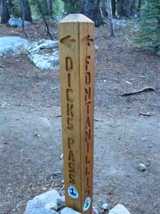
The Southern Bayview Trail Junction
Bayview Camp Trail, Dicks Lake, or Dicks Pass,
a confusing Junction...
Both of the trail posts here seems to have a Pacific Crest Trail emblem placed in confusing locations. This is typical of the PCT emblems in the Desolation Wilderness, by my reckoning. But it's really simple: The trail East is towards Bayview, the trail South heads up to Dicks Pass, and the trail North heads to Dicks Lake and on down to Fontanillis Lake. Unlike many segments of the Tahoe to Yosemite and Pacific Crest Trails the compass here lines up with the direction of the various trails. |
 |
|
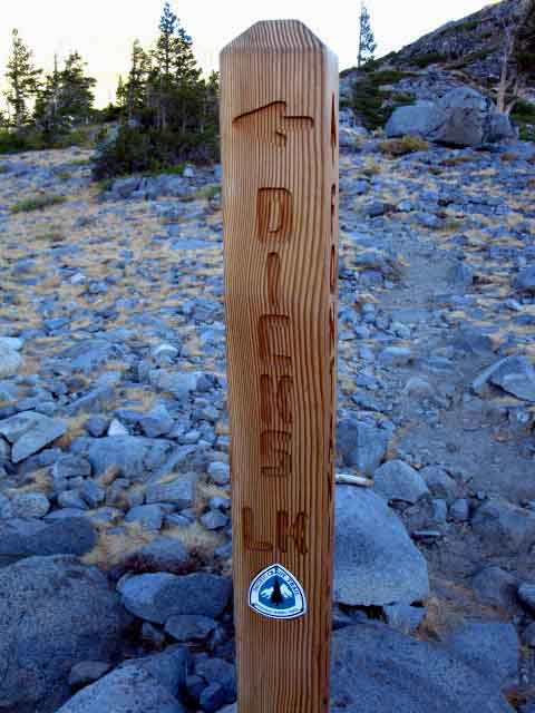
| This is the view looking East down the Bayview Trail in the background. The arrow is Pointing North towards North Side of Dicks Lake on the Pacific Crest Trail. Southbound hikers on the PCT-TYT-TRT veer right here towards Dicks Pass. |
This is the Southern trail junction for the Bayview Trail, which leads around Maggies Peak to terminate at Emerald Bay and Cascade Lake. The Northern Bayview Trail junction intersects with the Tahoe Yosemite-Pacific Crest trail between Middle Velma and Fontanillis Lake. |
 |
|
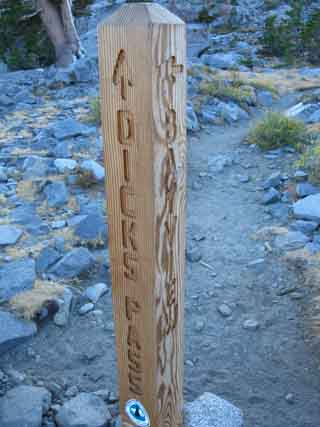
| Our view here of the PCT heading South towards Dicks Pass, behind the sign post, is a Right turn for Southbound backpackers. | Hiking in from the East on the Bayview Trail means left for the PCT South, right for the PCT North. |
Northbound backpackers on the Pacific Crest Trail will veer left at this junction to continue North on the PCT. |
| The Southern Bayview Trail Junction |
Desolation WildernessMeeks Bay
|
North TYT-PCT: Fontanillis Lake South TYT-PCT: Fontanillis to Dicks Pass
Discussion |
Okay, you confused at this junction? Good. I have been. Somebody gave away Pacific Crest Trail emblems, and it seems as if they put them on every trail post at this trail junction.
It's not a problem to maintain our bearings, despite the forest of trail posts.
I understand the theory; that each side of the post that points up and down the PCT gets a marker. The problem is that the opposite sides of the post often don't line up with the actually location of the trail, and rarely line up with the compass. The trail that lines up with South on the compass is not necessarily the trail heading South.
But, just keep head'n frk'n South! The compass works pretty well at this junction. South on the compass is also South on the trail. Don't head East. Southbound hikers stay to their right to keep heading South to Dicks Pass.
We are going South and up, up to Dicks Pass, not East over the low rise towards Lake Tahoe, nor West down one of those "little" paths down to Dicks Lake. Unless you want to. Then do so, by all means!
Topo Hiking Map South Next page South: Fontanillis to Dicks Pass 1 |
Backpacking North Trail Guide |
 |
Backpacking South Trail Guide |
Backpacker Forums Post it on Welcome to Tahoe to Whitney
Anyone can post text comments in the existing forums, but only members can post up new topics, along with images, maps, and formatting. As we addressed some gear issues on the page above,
If you have experiences, comments, questions, trip reports, trail conditions updates or pictures and/or videos of the Tahoe to Yosemite Trail from Meeks Bay to Lake Genevieve, and camping around Lake Genevieve and up the valley, post up your images, experiences, notes, and advice here as an unknown hiker or as a member: Section
|
North TYT-PCT: Fontanillis Lake South TYT-PCT: Fontanillis to Dicks Pass 1
Trailhead
Contact
Alex Wierbinski

Backpacking Lake Tahoe to Mount Whitney
Your guide to the High Sierra Crest, including the Tahoe to Yosemite, Pacific Crest, and John Muir Trails
