

High Sierra
Backpacking
Trail Guide
Forums
Sierra
Weather
WeatherNotes Northern
Sierra Weather
Gear
Backpacking
Middle Velma Lake to Fontanillis Lake
Across the length of Desolation Wilderness
on
The Tahoe to Yosemite and Pacific Crest Trails
Languages
Trail Skills
Mountain
Safety
Food
Planning
Trail Arts
More
Information
Social
| Trail Guide Section INDEX |
North |
South TYT-PCT 2nd Jnct South of Middle Velma Lake |
Miles & Elevations |
Miles & Elevations IINDEX |
Lake Tahoe Basin Management Unit PERMITS |
All forest-wilderness PERMITS |
Local Weather All Sierra Weather |
Continuing South
Our Options from Middle Velma Lake
NORTH
WEST
NORTHEAST Middle Velma Lake to Eagle Falls Trailhead: 4.12 miles
SOUTH Middle Velma Lake Fontanillis Lake: 1.54 miles Dicks Pass: 4.51 miles Echo Lake Trailhead: 16.39 miles
Hiking South from Middle Velma Lake we are climbing out of the low point of our hike down from Phipps Pass. We are beginning our next climb South up to Dicks Pass via Fontanillis and Dicks Lakes on the combined Southbound routes of the Or we are approaching a key junction on our local Desolation Wilderness backpacking trip.
The distance from Middle Velma Lake to the top of Dicks Pass along the combined TYT-PCT-TRT is 4.51 miles, with a total elevation gain of 1430 feet, if hiking Southbound on the TYT is in our hiking plans.
Meeks Bay to Echo Summit
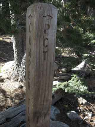
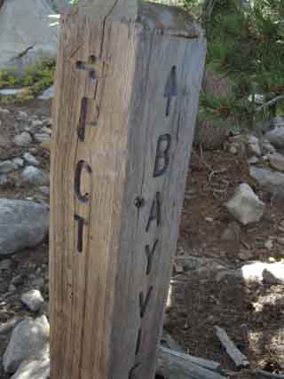
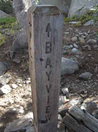
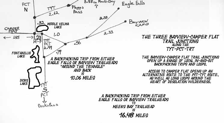
Just a tad South (.1) of our lunch spot besides the pond/inlet on the West Shore of Middle Velma Lake we come to our next trail junction, the Northernmost of three Bayview-Camper Flat trail junctions along the TYT-PCT-TRT. These are the three trail junctions along the route of the PCT, TYT, TRT connecting the Eagle Falls and Bayview Trailheads along the West Shore of Lake Tahoe with Camper Flat in Rockbound Valley.
This trail comes West from these two potential local-trip trailheads at Eagle Falls and Bayview Trailhead along Lake Tahoe's Western Shore. Their routes to Camper Flat join up after their divergent starts towards the Velma Lakes forms up into the "Velma Lakes Trail." These two Federal Trailheads are perched above Emerald Lake and below Desolation Wilderness along the West Shore of Lake Tahoe. LTBMU Forest Service Information
The trail coming up from Eagle Falls and Bayview Camp Trailheads unifies, then continues West through this junction at Middle Velma Lake on its way to Camper Flat in Rockbound Valley. The map Left below shows the trail to Camper Flat turning South through Rockbound Valley. Mosquito Pass at the South end of Rockbound Valley leads us back over to the TYT on the Northeast Shore of Lake Aloha.
For our practical purposes this "Bayview-Camper Flat" trail running East and West along, then across our Southbound TYT-PCT-TRT route, both opens up an interesting alternative route South through Rockbound Valley to that of our TYT route, while introducing the possibility of nice local loop routes around the heart of the Desolation Wilderness hiking West from any of the Desolation Wilderness Trailheads on Highway 89 along the West Tahoe Shore.
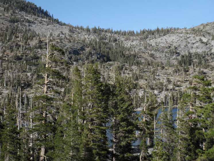
Three Well, not really alongside. We are climbing too far above Middle Velma to call it "alongside." The banner at the top of the page is a view from this climb East alongside Middle Velma Lake's South Shore. We are hiking up what is essentially a massive slab of angled granite topped with moderate+ density forest, set back a bit, and rising substantially above the South shore of Middle Velma Lake. We hike this slab across the short distance up to the second Bayview-Camper Flat junction. At the second Bayview Camper Flat junction we turn Right, South by the compass, to continue South on the combined Tahoe to Yosemite the Pacific Crest, and the Tahoe Rim Trails. Continuing straight through this junction keep us on track East toward Eagle Falls or Bayview Camp Trailhead. Alternative Route South TYT-Rockbound Valley-TYT TYT
And again, check out the Rockbound Valley Alternative Route, and various ways to approach it on these maps:
High Sierra Trails Forums
Share your experiences.
Post up notes about you favorite local trips into and out of Rockbound Valley and the North Desolation Wilderness. There's also a wide scope of terrain ideal for scrambling around the Velma Lakes and the basin they are situated in. |
Camper Flat
Trail Junction Information
Desolation WildernessMeeks Bay
|
TYT-PCT-TRT Well, each of these next three junctions to our South are instrumental for accessing-linking to Bayview Trailhead on the West Shore of Tahoe and Camper Flat in Rockbound Valley. To Our South 18.29 miles South to Echo Summit Trailhead |
Middle Velma Lake
The Low Point
Halfway between Phipps & Dicks Passes
Phipps Pass North Camper Flat Junction Elevation Mileage 4.41 miles South to top of Dicks Pass 7.95 miles from Phipps Pass to Dicks Pass |
Bailing Out Eastward
East Mileage East |
Alternative Route South
LOCAL
DESOLATION WILDERNESS
BACKPACKING TRIPS
Note that our route South across Desolation Wilderness on the Tahoe to Yosemite Trail from Meeks Bay Trailhead can be modified into a wide range of local backpacking trips remaining within Desolation Wilderness.
We can hike from one Desolation Wilderness Trailhead to another, even adding in a big loop around the center of Desolation by putting the parallel tracks of the TYT and the Rubicon Trail through Rockbound Valley to good use.
Or we can hike the length of Desolation wilderness as a "section" of trail along the TYT-PCT-TRT's shared route. It's a 28.71 mile trip hiking across the length of the wilderness from Meeks Bay down to the Lower Echo Lake Trailhead.
LOCAL BACKPACKING OPTIONS
Backpacking trips between trailheads, created by backpacking arcs through the North Desolation Wilderness, such as trips from Meek Bay Trailhead ending at Bayview Camp or Eagle Falls, measure out at 16.5 and 16.54 miles out of Meeks Bay, respectively. These are great trips for short getaways to refresh the mind and body.
Adding in the loop South through Rockbound Valley before rejoining and turning North on the TYT back to our Eagle Falls or Bayview exit trailhead adds about another 16 miles to our trailhead to trailhead hikes out of Meeks Bay to Eagle Falls-Bayview. Adding the Camper Flat loop to the Meeks Bay to Eagle Falls hiking trip brings the total to right around 32.6 miles.
Looking Over Local Trips
Backpacking from Meeks to Bayview or Eagle Falls takes us over Phipps Pass, where we got great overviews of the mountains surrounding the rock and basin below us that the trails to Bayview and Eagle Falls crosses. We would cross this terrain exiting the Desolation Wilderness if we turned East towards Lake Tahoe through the first two of the three Bayview-Camper Flat trail junctions.
That's if we are hiking East out to Highway 89 rather than continuing South on the continuing combined route of the TYT-PCT-TRT for the climb over Dicks Pass.
ROUTES EAST TO TAHOE
The route East to Eagle Falls tracks through the gap in the terrain below Phipps Pass, laying between Peak 9159 and the North flank of the Northern Maggies Peak. This is the gap Eagle Creek flows through below Eagle Lake.
The other trail East out to Lake Tahoe, out to the Bayview Camp Trailhead, gets East to Lake Tahoe by splitting the gap between the North and Southern Maggies Peaks on its way to its Highway 89 Trailhead.
REVIEW
FINE LOCAL HIKING IN NORTH DESOLATION WILDERNESS
We can review the full length of both of these routes on the Meeks Bay Trailhead Map, as well as using the map to identify the complex terrain we see looking Southeast from Phipps Pass.
We also got a bird's eye view of the terrain these trails cross on their way East to Lake Tahoe when we hiked over Phipps Pass. Expansive views of the basin holding the Velma Lakes spreads out below and beyond the North Flank of Phipps Pass.
Rockbound Valley
Alternative Route West
The Velma Lakes Trail continues West through its two trail junction South of Middle Velma Lake to Camper Flat in Rockbound Valley.
Hiking to Camper Flat in Rockbound Valley would be part of an extended backpacking loop around the Northern Desolation Wilderness. We would also be technically hiking out of the Lake Tahoe Drainage on our way to Camper Flat in Rockbound Valley. Rockbound Valley drains West through the Rubicon River down the West flank of the Sierra Nevada to the Middle Fork of the American River, not into Lake Tahoe.
At Middle Velma Lake we are standing at the top of the East-West drainage, with Middle Velma draining West.
East and West
Trails-Valleys-Drainages
At Camper Flat the East-West Velma Lakes Trail ends, and it still ends if you call it the Bayview-Camper Flat trail. At Camper Flat the trail tees out into the Rubicon Trail running North and South in Rockbound Valley.
Rockbound Valley contains the Rubicon Trail running North and South along the Rubicon River parallel to our route along the Pacific Crest Trail. Rockbound Valley is the next valley to the West of our unified TYT-PCT-TRT route. Rockbound Valley makes up the highest bits of the Western Flank of the Sierra here, as our TYT-PCT-TRT route is following the highest elements of the Eastern Flank.
Our TYT-PCT-TRT route crosses over to the Western Flank for a while when we climb up to the North end of Lake Aloha, which drains West down to the South American River at Twin Bridges.
Upper and Lower Echo Lakes are a toss up. There are channels that flow both East down into Lake Tahoe and West to the South Fork of the American River, and I have seen both of them running, though at different times. Though the creek running from Lower Echo Lake to the South American is not listed on the current USGS 7.5 map, it is shown on the old 30 minute map linked to below.
I have seen it running heavily, and forded it, during 2009.
Long Way Out
At the North end of Rockbound Valley to the North of Camper Flat we also have trail options bending West and Northwest to Western Flank Trailheads, such as at Loon Lake.
The Full Desolation Wilderness Backpacking Map lays out these West and Northwestern Desolation Wilderness backpacking options:
Full Desolation Wilderness
Hiking Map
As long distance backpackers focused on the Sierra Crest Trails we are more interested in the potential alternative route the trail South from Camper Flat through Rockbound Valley to Lake Aloha offers.
North of Camper Flat the Rubicon Trail exits Desolation Wilderness on the North shore of Rockbound Lake. Fairly long hiking routes can take us to the Northeast back to Lake Tahoe at Tehoma through McKinney Creek, or can lead West down the various tributaries flowing down the West flank of the Sierra from the Western edge of the Tahoe Basin, Most of which eventually flow into the Middle American River.
Download the USGS 30 Minute Maps
| Truckee | Placerville |
(Click the map image to download zip file.)
These 30 minute maps covering Rockbound Valley (and all West shore Lake Tahoe!) can be downloaded for free from The USGS, as well as all the underlying more detailed 7.5 minute maps.
Then we can display them on the free Adobe Reader.
Then we can slice and splice them up into custom maps through paint or photoshop, and print up our own custom set of backpacking maps for any trip through the Sierra, or anywhere in the United States.
Well, at least we have freedom of maps...
I love the USGS!, er, I mean the US!
Ha ha...
| Middle Velma Lake Forum |
Middle Velma Lake Comments |
The first Trail Junction
South
of
Middle Velma Lake
Northernmost
Camper Flat/Bayview/Upper Velma Trail junction just South of Middle Velma Lake
 |
 |
||||
 |
|||||
The Bayview Junction side is pointing us Eastward, towards Maggies Peak and the trailheads wedged in above Emerald Bay.
The Southbound Pacific Crest, Tahoe Rim and Tahoe to Yosemite Trails follow this route East for a quarter-mile before turning South at the next trail junction, the second junction South of Middle Velma Lake. At that point the trail East to Bayview and Eagle Falls continues straight.
|
|||||
Northwest Desolation Wilderness Trail Schematic
 |
Eagle Falls or Bayview Trailhead to Middle Velma and Fontanillis Lakes. Phipps Pass to Heather Lake |
Looking back at Middle Velma
as we climb
Southeast to the Emerald Bay-Fontanillis Lake trail junction
from the
Northern Camper Flat-Bayview trail junction.
Along the South Shore
|
 |
Looking almost directly North through the trees across Middle Velma Lake. It looks like Phipps Peak rising out of the Left background while on the right we can see where our trail hiking South from from Meeks Bay crosses Phipps Pass over to the Southwest draining flank of Phipps Pass. |
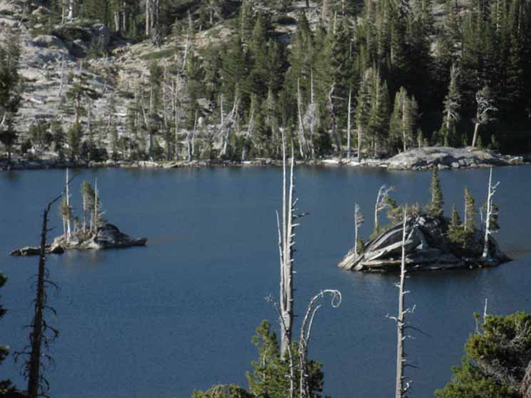 |
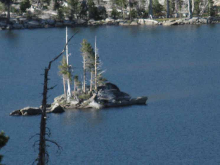
| Middle Velma's Rock "Turtles" |
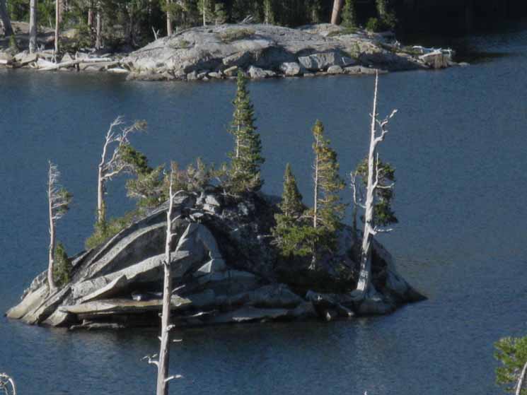 |
| Unique Rock Formations, Middle Velma Lake. |
 |
||
Unique Rock Formations, Middle Velma Lake.
|
Video
Backpacking South Past Middle Velma Lake, Desolation Wilderness
Looking Down on Middle Velma from Phipps Pass, then walking its South shore. Duration 2:48. Phipps Pass to Heather Lake
|
North: Middle Velma Lake South: 2nd Jnct S. of Velmas
Backpacking South |
||||
These pictures of the rock turtles on Middle Velma Lake demonstrate why it's good to run around off the trail occasionally. I had to run around for awhile until I found a good overlook to get a clear picture of the rock turtle formations. We could see them from certain positions while dropping down the South flank of Phipps Peak, but to get a good look we'd either have to camp and scout about at Middle Velma Lake, or find good overlooks as possible while hiking by. That's is why I generally try pack an extra day's food for each section of the trail between Lake Tahoe and Mount Whitney. Sometimes it takes a while to find a good overlook, to explore an interesting terrain feature, or to chase a butterfly around for a while. Food is time. I try to give myself time to observe everything I can. With a day's extra food I can take the extra time to explore and look around without worrying too much about running out of food towards the end of the section. Or I can spend a night in my favorite place. Or I can take a day off. Or a couple of half-days. Food is time, and time is flexibility. I believe our plans should include enough food to give us the time to explore off the trail a bit, take a off day, or just slow down a bit to enjoy, engage, and explore the local terrain we are passing through, if possible. Sometimes we've just gotta run! Flexibility's span includes exploration as well as the concurrent necessity of forced marches. Heck, I plan on having scramble days, when I use my extra day's food to climb some local mountains, scramble about, or explore a drainage I saw on a previous hike through the territory. Or I take a day off. It depends on how I feel, and what the situation offers and requires. In every case, each time I pass through a section I get to know a little more about it, which also shows how little I actually know about it. The wilderness is like a box that has no bottom: as far as you go, there is always more. See the black box at the bottom of the page, and the comments link just below? Those links to a place where you can relate how you got yourself to Middle Velma Lake, what you saw here, how you felt and feel about it, and your suggestions for other visitors.
Guide South |
Backpacking North Trail Guide |
 |
Backpacking South Trail Guide |
Backpacker ForumsGeneral Postings Backpacking Topics
South of Middle Velma LakeDo you Like the Velmas? How can you not? Have any good info on backpacking to the Velmas? Camper Flat? Rockbound Valley? Share it!Scrambling Around Here? Add your experiences, comments, or pictures about location:Section
|
North: Middle Velma Lake South: 2nd Jnct S. of Velmas
Trailhead
Contact
Alex Wierbinski

Backpacking Lake Tahoe to Mount Whitney
Your guide to the High Sierra Crest, including the Tahoe to Yosemite, Pacific Crest, and John Muir Trails
