|
Fontanillis Lake
Backpacking through Desolation Wilderness
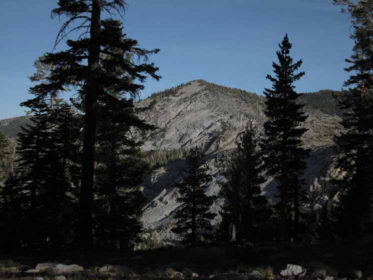
Ridgeline gap is Dicks Pass, Dicks Peak is the furthest Right peak, Jacks Peak Right behind.
Middle Velma Lake
to
Fontanillis Lake
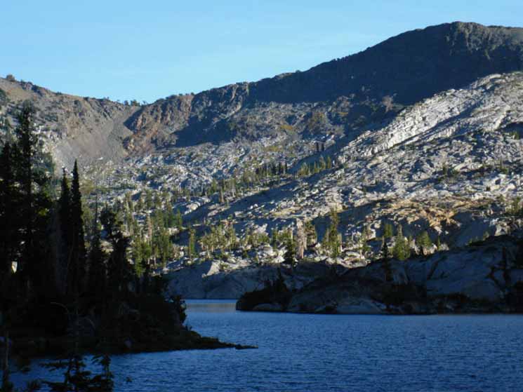
From the middle Camper Flat trail junction we turn Right, South (by compass and trail direction), for a brief 1.17 mile climb up 400 feet on a great forest-shrouded granite ramp of uniform grade to the North Shore of Fontanillis Lake.
This is a natural sweet spot.
Meeks Bay
to the
North Shore of Fontanillis Lake
Elevation
8360 feet
+440' elevation increase from Middle Velma Lake.
Mileage
1.54 miles South from Middle Velma Lake.
13.86 miles South from Meeks Bay trail head.
2.97 miles South up 1030 feet to Dicks Pass
from the North Shore of Fontanillis Lake.
14.85 miles South to Echo Lake trail head.
16.85 miles South to Echo Summit Trailhead
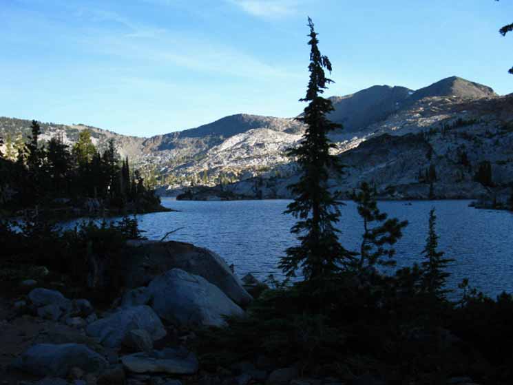
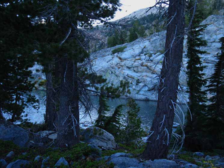
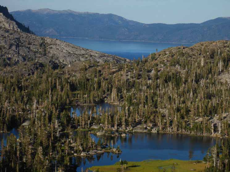
The North Shore of Fontanillis Lake is a sweet piece of terrain located where the fingers of the surrounding mountain ridges pinch their tips almost together around and across the bottom of the basin holding Fontanillis Lake. This configuration creates a unique area of closed-in terrain and climate where we make our last few steps to the lake's North shore off the top of the ramp. This terrain effect is well filled and magnified by the forest and rock filling it. The terrain is filled with clumps of dense forest in a granite rock garden that would be comfortable in a museum of natural beauty.
We observe lots of natural sweet spots hiking across Desolation Wilderness. This is one.
The trail twists around to a spot along the short flat wrapping around the far North shore of Fontanillis Lake, one amazing spot. From here we find a spot with a fine perspective South across the length of the center of the irregularly-shaped lake stretching out to our Southwest in its granite vault.
This unique position gives us a rare and delightful view across the narrow, oddly-shaped length of Fontanillis Lake highlighting its granite-encased Northern shoreline and the stunning red volcanic canyon rising to Dicks Pass and Peak beyond the lake.
The Plan
Always the Plan
Spots like this are why we must be very observant as we hike down the trails. We don't want to hike past beautiful viewpoints like this in a haze of our own making. Our basic hiking plan is built on the fundamental imperative to fully support careful observation by giving ourselves the time to observe. One of our objectives is to soak in all the subtle terrain features, changes, textures, and colors each segment of the trail presents. We seek the precision of detailed close observation and the broad perspective imparted by long overviews.
The real goal of our hiking plan is not only to survive getting us from point A to B, but to support a sophisticated understanding the logic driving the local terrain configuration by observing the details and overall character of each segment of trail as we push into the next.
Ride the Big Ones
A fully prepped backpacker rides their hiking plan like a surfer on a big wave. Our plans will create the space we need to carefully observe, absorb, and understand the trails we hike. If successful, we will make ourselves part of this grand terrain if our physical status is strong, our logistical support solid, the daily hiking plan reasonable, and our minds clear.
We must be far enough above the level of basic survival to set our minds free as our bodies work hard. Observation is hindered when we are in pain or exhausted. We become dangerous to ourselves and others.
Looking South across Fontanillis Lake we can make out the upper ledge of the next level of the set of basins stair-stepping up the canyon above us where Dicks Lake is hiding, with Dicks Pass rising above that. Dicks Pass is the low point at the top of the massive ridge running Northwest from Dicks Peak.
The Northern Ridge Arm descending from Dicks Peak both makes up the West wall of the canyon wrapping around Dicks and Fontanillis Lakes to our Southbound Right, which is also the East wall of Rockbound Canyon.
Velma Lakes to Echo Summit MAP
Central and South Desolation Wilderness
We note that the North and South Shores of Fontanillis Lake are separated by a pinching neck of granite. Our trail South hikes us alongside this narrowing neck on a narrow shoreline path. A short hike South from our overlook along the North Shore of Fontanills Lake lake brings us to a shallow climb. We climb above the lakeshore to trace out a high line South paralleling the South end of the lake down to its South Shore.
Desolation of Contradictions
Again, I've got to say this place, this piece of terrain is a museum-quality run of classic natural beauty. Desolation Wilderness is virtually a slice of preserved intense natural beauty as close to major population centers and main roads as is humanly possible.
In a way this takes away from the experience. Not the attempts at maintaining wilderness, but the close proximity of "civilization" itself. The proximity of "civilization" has a deep effect on the wilderness that we can see and feel. All the trails in Desolation Wilderness are deeply cut into the terrain. All the possible camping spots have been camped on, and the potential campsites near the trail exhibit extremely compressed soil. The signs of man are everywhere, extending across scrambling routes on the verge of becoming "trails."
Understand that we are not getting away from people in Desolation Wilderness. We are decreasing their density.
The trails over meadow or spring must be armor-plated, or they will become a total mess. Only serious restrictions on backpacker activity preserves its beauty. Desolation Wilderness operates at capacity during the high Summer backpacking season, and has folks hiking it all year long.
No Desolation in Desolation Wilderness
There is no desolation in Desolation Wilderness, so don't expect any, either in the signs of heavy use written onto the physical beauty of the terrain or by the proximity of other backpackers. Enjoy both, for what each offers, because that's what we've got here.
A pocket of extreme beauty heavily used by vast nearby populations.
Filter Factors
I've always called the wilderness a "people filter," in that the density, difficulty, and distance of a particular wilderness area acts to reduce the number of folks there.
The Density of Nature
By density, I mean the ratio of human to Natural influences. First is the physical isolation factor. I speak to how far off the "beaten track" we have to go to get to the trailhead. Yosemite and Desolation rate near ZERO Natural Density during their "high" seasons. The next factor is season. Winter provides the highest degree of natural "density" at any position in the High Sierra, up to MAX, and Summer the lowest, down to ZERO. The next factor in density is road access. If no road goes there, or it is an isolated location, we will see fewer folks.
Difficulty is self-explanatory. The more difficult a route or trail the less backpackers. This is becoming less true as our vast irresponsible expansion of population has produced a huge population now accessing everything.
Distance too is self-explanatory, both the distance of the trip and the distance of the trail from "civilization." Long distance backpackers used to be rare. Now the sizes of both the PCT and JMT crowds are approaching obscene proportions.
There are now lots of people everywhere.
In 2015 record numbers of Pacific Crest and John Muir Trail hikers hit the trails. (2017) This would be good if the total of our population was not so large as to crush Nature by virtue of its size alone. While that direct danger is true, the size of our population has grown its sub-population of backpackers large enough to overwhelm nature through direct overuse as well as the more general environmental degradations brought on by overpopulation abuse.
We are undermining Nature through a system of globalized irresponsible growth issue which has resulted in vast populations in direct contact with the remnants of unspoiled Nature.
The existence of, then the proximity of our vast Mega-Cities of tens of millions of consumers to a particular wilderness area is
predictive of its fate.
Preservation Exercise
It's really quite amazing here at Fontanillis Lake. Heavily used trail and terrain, lots of humanity, all in the stunningly beautiful terrain within the unique complexity of this great chunk of the Crystal Range's granite portion of the North Sierra Crest line wrapping around the West shore of Lake Tahoe.
Good Work
I've got to say that the managers, rangers, and trail crew of the Lake Tahoe Basin Management Unit have done a great job of preserving the Desolation Wilderness. Especially when we consider the density, difficulty, and distance factors of Desolation Wilderness are so low.
Desolation Wilderness proximity to major population centers in California and Nevada doom it to be loved to death, if extreme measures are not taken to preserve Desolation Wilderness and places like it.
Ending our crazy endless irresponsible growth would be a logical place to begin protecting Nature,
since our wildly irresponsible growth is what is destroying it.
We've grown to the point that places like Desolation Wilderness are tiny little islands of natural terrain sinking under a rising tide of relentless growth. The threat is not just direct, from too many visitors, but from the vast changes in the progression and character of the seasons this irresponsible growth has set in motion.
People, Sky, and Terrain are all showing the strain. |
North Shore
of
Fontanillis Lake |
Backpacking
Desolation Wilderness
Meeks Bay
to the
North Shore of Fontanillis Lake
Elevation
8360 feet
+440' elevation increase from Middle Velma Lake.
Mileage
1.54 miles South from Middle Velma Lake.
13.86 miles South from Meeks Bay trail head.
2.97 miles South up 1030 feet to Dicks Pass
from the North Shore of Fontanillis Lake.
14.85 miles South to Echo Lake trail head.
16.85 miles South to Echo Summit Trailhead
Arriving at the North shore of Fontanillis Lake roughly marks the halfway point of our trip across the Desolation Wilderness out of the Meeks Bay Trailhead.
Meeks Bay to Echo Summit
Backpacking Miles and Elevations
top of page |
View South
from the
North Shore
of
Fontanillis Lake
| |
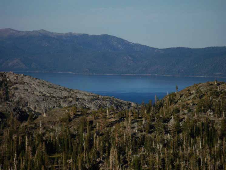
Looking South across Fontanillis Lake at Dicks Pass, Jacks Peak, and Dicks Peak. |
|
| |
 |
|
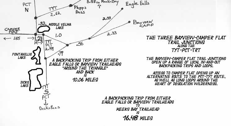
The highest peak on the Right of the image and nearest to us is Dicks Peak, which, along with Jacks Peak behind it, makes up the far Southeastern flank of Rockbound Valley. Rockbound Valley lays over on the other side of that mountain, and the trail through the length of Rockbound Valley runs parallel with our Tahoe to Yosemite Trail route South from Middle Velma Lake to the North Shore of Lake Aloha.
We discussed our route options South through Rockbound Valley at the Northernmost of the three Bayview-Camper Flat trail junctions, where we find our trail leading West into Rockbound Valley from Middle Velma Lake.
If you remember, we Southbound TYT hikers turned Left at the trail junction just South of Middle Velma Lake. Turning Right at that point would have brought us West down to Camper Flat. From there we could have turned Left, to the South towards Mosquito Pass as an alternative route South to the junction with the PCT-TYT on the North shore of Lake Aloha.
The trail South through Rockbound Valley crosses Mosquito Pass under the Southwestern ridge arm descending off Jacks Peak. Crossing Mosquito Pass brings us to the North Shore of Lake Aloha, where our route through Rockbound Valley rejoins the Southbound route of the TYT-PCT-TRT.
Rockbound Valley is an alternative route to the TYT-PCT through the Desolation Wilderness, or can be part of a big backpacking loop around the Desolation Wilderness. Both are always on my list!
Post up some information on the Crystal Range and Rockbound Valley if you've hiked this route up to the headwaters of the Rubicon River, though Mosquito Pass, then post up through the comments link below.
I'd love to see some pictures of it. It looks great from every angle I've viewed it.
Show us yours!
top of page |
Lay of the Land
Continuing South from the North Shore of Fontanillis Lake quickly exchanges our long view of this convoluted lake and its surrounding valley for delightful scenes of dense forest, unique granite formations and shapes, and glimpses of Fontanillis Lake through both tree and rock off to our Right, the West, as our Southbound trail bends away from Fontanillis Lake.
The terrain and logic of trail design pushes the trail up and away from the East Shore of Fontanillis Lake.
After climbing a short distance up and away from the lake's shore the trail parallels the Eastern shore of Fontanillis Lake from less than a hundred feet above lake level.
As the trail begins passing the South shore of Fontanillis Lake the trail bends down towards lake level again, moving down towards the outlet creek draining from the North shore of Dicks Lake above, down to the furthest South shore of Fontanillis Lake.
Fontanillis Lake South Shore Campsites
At this point as we pass the South shore of Fontanillis Lake we see that we can hike down to the lake, where we will find good campsites.
If we continue following the trail South beyond the South shore of Fontanillis Lake to the trail's lowest point between Fontanillis and Dicks Lake we will begin to find a series of faint unmarked trails breaking off to our Southbound Right, to our Southwest by the compass, up to the North Shore of Dicks Lake above us. Here we find our first access to campsites around the South and West shores of Dicks Lake.
The faint trails breaking off to our Right lead to Dicks Lake Campsites.
We continue South on the TYT up the short climb from the South end of Fontanillis Lake to the third and final Bayview-Camper Flat junction.
Continuing to hike East by the compass on the Southbound TYT from this point below the North shore of Dicks Lake bring us up to the third and Southernmost of the Baview-Camper Flat trail junction.
Approaching the junction we note that there is a continuous series of faint trails branching off to our right, to the South and Southwest by the compass, leading over to campsites located along Dicks Lake's South and Western shores.
top of page |
Scenes along Fontanillis Lake
 |
| Peak 9190 East of Dicks Lake, North of Dicks Pass. |
 |
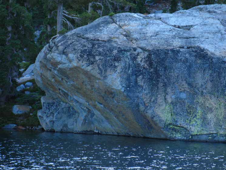
| A finger of Fontanillis Lake passes between massive granite pincers, joining the North and South sides of the lake. |
 |
| Massive Granite Overhang. |
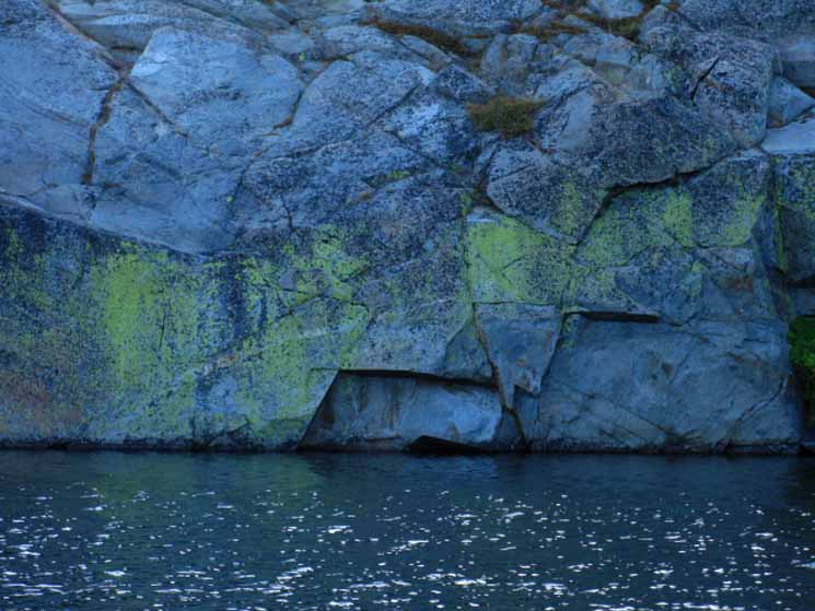 |
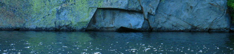
Massive Granite shoreline Splashed with Algae.
top of page |
| Fontanillis Lake combines granite, forest, and water to create a unique atmosphere. |
The Ground Underfoot, The Sky Overhead
Camp Notes
Arriving Fontanillis Lake
Location
Approaching the furthest Southern Shore of Fontanillis Lake we look off trail to scramble down towards the lake before beginning climb towards Dicks Lake and the second Bayview trail junction.
At the far South end of Fontanillis Lake we can either begin climbing again towards the South shore of Dicks Lake, or step off the trail to our Right, to hike down to the South and Southwest shore of Fontanillis Lake to scout out a campsite.
There are lots of established primitive campsites and suitable sites for camping.
There are nice campsites all around the Southern shore of Fontanillis Lake. There are campsites all over Desolation Wilderness.
General Conditions
Sunset, Late September 7:08 pm or so
Temp before Sunset: Mid-50's
No weather, no mosquitoes: no tent
"or so" note: I record the Sunrise/Sunset times and their compass points, the time of the transit of the Sun (daily crossing of N-S line in the sky), and the Moon Phases for the day each trip begins as the header of my journal.
This allows me to use the Sun as a compass and a clock.
Sun, Compass, and Map
The astronomical times I record are the compass points and exact times of the Sun's rise and set times, and its transit across my meridian.
I record these facts
for the start day of the trip. In fact, each subsequent day the Sunset and Sunrise times change, so the accuracy of my readings diminishes slightly every day.
The transit time of the sun across the N-S line (always local Noon) stays very consistent during the span of each season.
For long trips I record the times of sunrise and set at five day intervals (and their corresponding compass points. Or, I carefully note the daily rate of change to adjust my original figures over the duration of the backpacking trip.
The rate of change is up to a minute a day for both Sunrise and Sunset. Using this system I can be very accurate at telling time and direction without a clock or compass. Just my mind reflecting the idea time is the movement of space... anchored on a frigging piece of paper. Unless it gets cloudy!
I once did dead reckoning navigation in a super-dense fog on the snow covered mountain behind Little Antelope Pack Station. I was pointing for the traverse down the mountain to the pack station, normally an easy task. But there is a snow cliff just steps Northwest of where the safe traverse begins.
Both were invisible in the fog. Seeing my hand at the end of my arm was sometimes possible.
I actually managed to find the big cairn using only the compass in my hand and the one in my head. Hey, the head has to decide which compass point in the hand to follow, and when to adjust it. From the carin to the route traversing down the snow covered mountain side to the pack station was the crux move.
I considered it a successful effort because I did not walk off the cliff.
What time should it be?
When it is cloudy we can use our compass to locate the places in the sky the sun should be, and the places on land that should bring us to know terrain, all the while entertaining the hope the sun will appear at least momentarily to allow us to accurately reestablish our relationship between the compass, time, the physical space around us, and our position and potential within them.
Forget watches
and
Global Positioning Systems
These self-contained practices using astronomical information and observations to determine time and direction help keep us internally and externally orientated. No GPS or Timepiece necessary.
We use our minds and powerful concepts of physical relationships to align our compass and internal clock with our map to situate ourselves perfectly in the physical reality surrounding us.
When these observational practices are combined with map reading and alignment with the local terrain as we travel we will maintain a precise understanding of our location in time and space without electric devices.
We will be observationally engaged with our location, not electronically.
At night our celestial compass and clock are better aligned than the most precise instruments. Instruments only give us a false measure of what must be seen and felt to be truly understood.
We were designed with these fundamental inherent abilities. We just need to find and align them again.
Backpacking Navigation
Astronomical Information
top of page |
Looking towards tomorrow's Hike
Dicks Pass
| The Extent and Terrain Surrounding Fontanillis Lake Reveals itself. |
 |
Long Look South across Fontanillis Lake
Dicks Pass is the low point in the far ridge. Well, not really. An inspection of the USGS map puts Dicks Pass to the Left, East, above the low point of this mountain ridgeline. Technically speaking, the low point in the ridgeline dividing two valleys is the pass, no matter what the map says.
We actually hike down to the low point in the gap from where Dicks Pass is located on the map.
Weird. Post up to tell me why this is so.
The high point on ridgeline to the Right of the low point is a low rise on the ridgeline climbing up to Dicks and then back, to the Southwest, to Jacks Peaks, though both peaks are out of this image's Right side. That low crest along the ridgeline marks a fold in the mountains between Dicks Pass and Dicks Peak feeding a lake and creek that eventually flows down into Fontanillis Lake. Details-details. Figuring out this complex terrain is an endless exercise of observing and analyzing details before, during, and after backpacking trips...
Phipps Pass to Heather Lake
15 minute topographic backpacking
MAP
Above we see Fontanillis lake draped in the quickly creeping shadows of a late Fall afternoon. Shadows are now appearing and growing out of all points on the terrain. Time to start looking for a nice campsite, while pushing as far forward as possible.
This entails calculating how much time we have to find campsites on the South shore of Fontanillis Lake, or if we can even get up to the North shore of Dicks Lake. More sites there.
Dicks Lake is located on a shelf in the terrain above the South end of Fontanillis Lake at the base of the steep flank up to Dicks Pass. In the image above we can see a treeline running across the terrain halfway between the South shore of Fontanillis Lake and Dicks Pass. See that treeline running across the image above? That treeline identifies the level of the shelf holding Dicks Lake behind it.
Let's look North at this scene from a different perspective, looking North back down on where we are now standing on the North shore of Fontanillis Lake from Dicks Pass. |
North TYT: 2nd Jnct S. of Middle Velma South TYT: 3rd Bayview Junction
Backpacking
to
Fontanillis Lake |
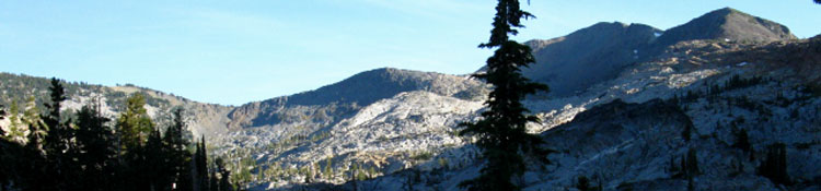
Backpacking 400 feet up and 1.17 miles past the second Bayview/Eagle Falls junction (South of Middle Velma Lake) brings us up to the Northern end of Fontanillis Lake. From here we can see our next objective/obstacle to the South: Dicks Pass. Dicks Pass is the Southern exit out of the valley holding Fontanillis and Dicks Lakes.
After a brief hike South along the Northern tongue of Fontanillis Lake, the trail climbs over a shoulder of the mountain before coming back down towards the South shore of the lake.
As the shadows spreading across the terrain in the above pictures indicate, the sun was rapidly sinking towards sunset, but I figured I had enough light to make it to the South end of Fontanillis Lake.
comments?
Velma Lakes to Echo Summit MAP
Central and South Desolation Wilderness
Miles and Elevations
Next page
3rd Bayview Junction
top of page |
Hiking from the North to South
shores of
Fontanillis Lake
to my
Second
Tahoe to Yosemite Trail
Campsite
Fontanillis Lake II:
South Shore |
Desolation Wilderness
Meeks Bay
to the
South Shore of Fontanillis Lake
Trail Around South Shore of Fontanillis Lake
8360 feet
At the South end of Fontanillis Lake we begin a 120 foot climb up .65 of a mile to the Southernmost of the series of three trail junctions that lead East to the Bayview and Eagle Falls Trailheads along the West shore of Lake Tahoe.
Or we don't.
We can bend West off the trail where we see we are passing by the South end of Fontanillis Lake to seek out one of the campsites ringing the South shore of Fontanillis Lake. Or we can begin to climb to our South.
The climb South from the South end of Fontanillis Lake first brings us to a couple of faint trails continuing South to the North shore of Dicks Lake where the main trail turns ninety degrees to the East for the short climb up to the Southernmost of our Bayview trail junctions.
Below is our position along the Tahoe to Yosemite Trail hiking across the length of Desolation Wilderness:
South End of Fontanills Lake
from
Middle Velma Lake
2.21 miles South of Middle Velma Lake
+440 feet from Middle Velma Lake's 7920 feet of elevation.
Fontanillis Lake
8360 feet
2.3 miles South to Dicks Pass
+1030 feet to Dicks Pass' 9390 feet of elevation.
South Shore of Fontanillis Lake
Mileage
14.53 miles South from Meeks Bay trail head.
14.18 miles South to Echo Lake trail head.
16.18 miles South to Echo Summit
Trip Planning
The Hiking Plan in Motion
Meeks Bay to Echo Summit
Backpacking Miles and Elevations
Local Backpacking Loops
The two trails Southwest from Eagle Falls and Bayview join together then split apart approaching the TYT-PCT.
The Northern trail leads to Middle Velma Lake to the North of Fontanillis Lake while the Southern trail leads to the trail junction South of Fonatinillis Lake.
It's 3.89 miles from Middle Velma Lake to either Eagle Falls or the Bayview Campsite Trailheads.
It's 3.68 miles from the trail junction South of Fontanillis Lake to either Eagle Falls or the Bayview Campsite Trailheads.
It's 2.49 miles from Middle Velma Lake to the trail junction South of Fontanillis Lake.
North Desolation Wilderness Backpacking
That puts backpacking loops out of Eagle Falls or Bayview Trailheads to Middle Velma past Fontanillis Lake back to our respective trailhead at
10.33 miles
Hiking in through Meeks Bay Trailhead and hiking South to Fontanillis Lake and out through either Eagle Falls or Bayview Camp is
18.07 miles |
top of page |
Middle Velma-Fontanillis Lake
Backpacking Schematic Map
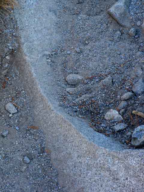
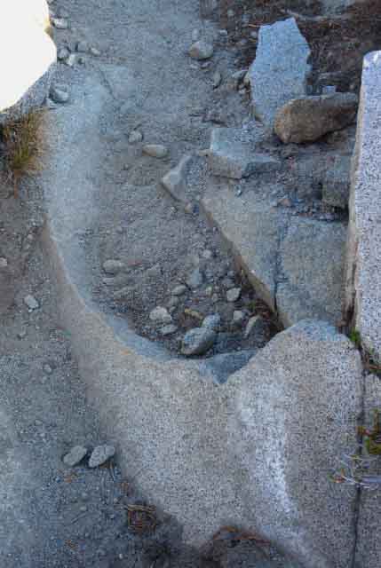
Exceptional Exfoliation
Exceptional Exfoliation
Detail. Full picture below. The original huge exfoliation happened long enough ago to be almost filled in and covered by soil from countless rain and runoff cycles. |
Considering the Beauty of Fontanillis Lake in the Valley below Dicks Pass
Hiking with Al
The exfoliation feature above highlights the fact that terrain is in motion. Some terrains move slowly, others rapidly, but everything is in motion.
Forever in a Glance
Much of this motion is discernable over a few seasons. Other times we only see the "result," seeing only a thin slice of time and perspective of a scene changing through eons of gradual movement, such as the slow processes happening to the rock fragment above. Subtle yet inextricable forces are slowing moving and sculpting the great mountain ranges surrounding us at Fontanillis Lake.
Around this shard of exfoliation above I can picture countless seasons of cooling, heating, internal stresses and external shifts in pressure first cracking this graceful arc off its mother rock, then tens of thousands of Fall rains and Spring runoffs carrying layer after layer of sand and rocks down slope to deposit sands representing almost unseen forces slowly leveraging this exfoliating formation further and further from its mother rock until it exists as a independent piece of living art partially submerged and still moving in currents of sand and soil for our momentary viewing pleasure.
A sweet slice in time, baby!
The theories about why this happens are as varied as the beauty exfoliation creates.
The semi-submerging of this granite fragment in eroded tailings happened as it peeled off from its mother rock during its transition from a granite block into a granite boulder. We can see that the same exfoliation process that cracked the forms of the great domes rising out of Yosemite Valley is also working on the micro-scale carving granite slabs and boulders up and down the Sierra Crest.
Seasonal Timer
The progression of the seasons times the "bloom & blossom," and times the actions of everything else. From the Fall shut-down of life to its resurgence during the annual Spring Runoff, Bloom and Blossom, everything from the tiniest bacteria and molds through the insects, to the bears and birds, to our very own crops, everything depends on the character and timing of the progression of seasons, which establishes the strength, length, and depth of life's fertility and bounty every year.
Great Engines of Life
The seasonal transitions push what I call "The Engines of Life." These are the great Blooms of Life caused by seasonal shifts in wind patterns with the changing angle of the Sun. These shifting winds push shifts in great oceanic currents that feed great blooms of algae and plankton which in turn drives the movements and feeding patterns of great schools of fish during these seasonal shifts.
The migration and breeding patterns of land animals, the insect kingdom, and the birds are all timed to exploit the Spring Bloom's bounty.
Life on land, sea, and in the air are all tied and interlinked to each other and our behaviors timed to depend on these great seasonal Engines of Life. The character and progression of our seasons is not just limited to timing the rise of life in Spring and its recession in Fall.
Hitting the Brakes
The timing and character of the progression of the seasons does not just affect bloom, blossom, and seed times of the plants and the migration and breeding schedules in the animal world. The character of the weather also establishes the speed of weathering, erosion, and runoff sculpting of the natural terrain itself.
The progression of the seasons determines the rate of change of the physical terrain itself as well as the timing and feeding of the biological cycle of life nestled within the physical terrain. Living things can alter the terrain as much as erosion in some locations.
The changed character and timing of the seasons have already altered the pace and timing of the Spring Bloom as well as the "timing" of erosion of the physical terrain and how living things interact with the terrain in the High Sierra. The character and timing of the seasons continues to change rapidly.
The lengthening of Summertime, Fall stretching into short, abrupt Winters has disrupted the Engines of Life over water, land, and along the High Sierra.
It appears that the rate of changes in the character and timing of the seasons is actually accelerating. Summer is getting yet hotter and drier. Fall is becoming the "new" Winter, and Spring is beginning and ending earlier each year.
These changes have slowed the forces of erosion. The diminishment of the Spring Bloom has lessened the power of life in the Sierra, and the diminishing water supply has slowed the growth and movement of the forests. The forces of water and forest cracking High Sierra granite have radically diminished over the past 40 years.
Forever in a Passing Second
Physical engagement with nature while reflecting the natural process through our perception is a fundamental pleasure of backpacking. Backpacking reminds us of what our minds and bodies were originally designed for, within, and by.
My joy in observing this exfoliation feature and the long processes surrounding it are enhanced by my physical stress, while my perception goes beyond the alluring beauty of its shape itself and is expanded by enjoying the processes that controlled and created its beauty over time, and that of the surrounding valley, all of which become visible during this very brief instant we pass through it.
This shit is special. Take the time to consider it carefully, as well as withstand it physically. Take all the time you need to see forever in every second you observe carefully.
New framework of perception
That's the fundamental reason I'm a solo long distance backpacker. Company is nice, but it tends to center too much of my attention on the social environment, rather than allowing my mind to settle on the fundamental operations of the natural environment.
Adjusting the body and mind over many days of hard travel through stunning natural terrain tunes the senses to nature, if you allow it to, which contributes to breaking-readjusting-our mental perceptions, definitions, and assumptions of what actually constitutes pain and pleasure. The natural environment will change the fundamental way we think and feel, if we let it.
Different folks go through this at different rates of adaptation.
Replacing the social environment with Nature is the first step. Elimination of social chatter and social assumptions is a second step.
Dissolve Social Assumptions
Things are not as cut and dried as they may first appear. "Social" expectations condition and frame experiences even when we're outside the city and far removed from social situations.
This "breaking-readjusting" our perceptions and definitions from social to natural is potentially a harsh process. But not necessarily so. Planning and preparation is the Key.
Hardening your body a bit with some pre-trip training and even a short "practice" backpacking trip or two can clear away or solve many of the little problems that will drive us crazy on a long trip.
Blisters, ass rash, and gear issues are best worked out on short trips.
Planning the first days of our backpacking trip with gradually increasing workloads over time can be essential for laying the foundation for successful long distance travel. Independent of how well trained we are, there will be an adjustment phase transitioning between city sidewalk and High Sierra trails.
I call this the "transition" period. I have also referred to this process as "the scraper." Long term high mileage emersion in Nature, especially the harsh beauties of the Sierra Nevada, scrapes away social distortions.
After the trail and us get together to redefine our perceptions, re-tune our metabolism, and re-set our concepts of time and space, we are properly tuned to accurately perceive and move effectively through the natural environment. Put on your seatbelt! My point of transition is generally three to five days down the trail, from wherever I start.
The transition from social noise to natural noise creates what I call "roar of silence, " when the gaping void of urban background noise makes the lack of noise roar.
The simultaneous adjustments of our metabolism to thin air and the muscles to high angle trails is worked out in our heart, lungs, and circulatory system.
The specter of working all day long under a heavy pack can test all aspects of our existence. That's why I urge preparation through training and developing skills and breaking in gear on short prep trips. Make the transition as seamless and painless as possible.
Once these pains of transition are accommodated their previous constraints become the foundation for greater physical and spiritual engagements.
Ticket Please
The beauty of nature has a brutal backside in its high admission price. Every step can be hard work. The pack can pain the shoulders, the rocks can batter the feet. Every obstacle can weaken you. Each obstacle must be overcome while laying your own foundation for long term safety in strength, endurance, perception, engagement and growth.
This is our ticket to a lifetime of deep engagement with both the world around us and the things within us.
The end of this process is the beginning. Now that you are achieving access to nature and your inner potential it again comes down to the same question:
What to do with it.
How you answer this final ongoing question defines your character. It is like dotting the "i" or crossing the "T." First you gotta get there, then you gotta do it.
I say "enjoy the hike, the natural environment, your fellow hikers, and yourself."
top of page |
Details of Trail and Terrain
between
North and South Shores
of
Fontanillis Lake
 |
| Delightful Trail Feature: Full Exfoliation. |
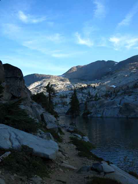 |
North Shore of Fontanillis Lake looking South.
Shadow over trail along Eastern shore of Fontanillis Lake. Shadow descending over the Southeastern Flank of the Crystal Range beyond.
top of page |
Exceptional Views
of
Lake Tahoe
reward us for our brief hike
South
up from
Fontanillis Lake's Northern Apron
 |
Climbing South from Fontanillis Lake's Northern shore first brings us around the lakeshore then we make a short climb bringing us to a unique high spot along the trail with an amazing view Northeast. We have climbed up to the narrow space between the two rock prominences rising above the Northeast Shore of Fontanillis Lake.
Looking Northwest across Lower Velma Lake in the foreground we identify the sheer rock dropping down from Left-to-Right as being the middle and lower face of the ridge descending directly North from Phipps Pass. Peak 9195's Southeastern Flank is visible behind. Peak 9195 is just a short distance to the East of Phipps Pass.
The ridge arm descending in the foreground from Right-to-Left is Peak 8197 along the gorge down to Lake Tahoe. The trail to Eagle Falls is out of the Right edge of the image above. It is skirting around to the North on the Northwest Flank of Maggies Peaks.
In the furthest distance we see Lake Tahoe's Eastern shoreline over in Nevada across the lake,
backed-up up by the Carson Range.
Carson City lays in the Carson Valley on the other side of the Carson Range. |
 |
The same view of the Carson Range on the East side of Lake Tahoe as above, but at the max power of my mini-camera. The Eagle Falls Trailhead is at the bottom of the gorge in the foreground.
Phipps Pass to Heather Lake
15 minute topographic backpacking
MAP
That's a shoulder of Peak 8197 in the Right foreground. Maggies Peak sits off to the Right behind 8179, and Emerald Bay sits below and behind Maggies Peak. |
Finally
Camp on the South Shore
of
Fontanillis Lake
Around Fontanillis Lake
A brief hike South from the North Shore of Fontanillis Lake brings us up and over the granite prominence separating the Northern and Southern wings of Fontanillis Lake.
Alter climbing up this rock feature and getting the views above from the Northeast shore of Fontanillis Lake our trail continues South on a course paralleling the Eastern shore of Fontanillis Lake, but from above.
The trail begins to bend down to pass near the South Shore of Fontanillis Lake before turning East for the short climb up to the third Bayview Trail junction.
Phipps Pass to Heather Lake
15 minute topographic backpacking
MAP
The Southernmost of the three Bayview Trail junctions is located to the East, above the gap between North shore of Fontanillis Lake and the South shore of Dicks Lake.
Our hike up to the third Bayview Trail junction brings us up to access to our Southbound trail's route traversing route up the East Wall of the steep bowl climbing high above the East shore of Dicks Lake to Dicks Pass.
Instead of passing the South Shore of Fontanillis Lake I cut off the trail at the lake as the trail approached its Southern Shore and hiked Northwest down to the lake, and found a nice little campsite above its Southeastern Shore.
Time to kick back. |
 |
| Campsite on Southeast side of Fontanillis Lake. |
 |
View South from camp site. Forest and Rock tilted down towards Fontanillis Lake. The trail South is up and to the Left from this perspective, the lake off to our Right.
|
Camping Notes
Departing Fontanillis Lake
Sunrise, Late September 6:42 am or so
Temp before Sunrise: 43°
Clouds in morning, cleared nicely. The lack of mosquitoes and weather allowed me to use my tent as a pillow.
"or so" note: I record the Sunrise/Sunset times, the time of the transit of the Sun, and the Moon Phases for the day each trip begins as the header of my journal.
Astronomical Information |
Night two
Campsite at Fontanillis Lake |
The Hiking Plan in motion
Considering
Mileage, Food, and Physicality
Twilight was settling in over the basin holding Fontanillis Lake as I was climbing over the hump dividing the Northeastern from the Southeastern shores of the Lake. I was pretty thrashed after covering only 10.4 miles. But the 75 lb+ backpack was really a chore.
The second day out is when your trip planning, our daily hiking plan, and our food and rest calculations all come home to roost.
comments-questions-your hiking plan experiences.
Remember, on my last trip through here I was carrying enough food for the whole 176.04 mile trip between Meeks Bay and Tuolumne Meadows on the Pacific Crest Trail route. Keeping track of food consumption verses planning assumptions is going to be an important factor affecting how many miles a day we are going to have to hike.
Don't worry if you are tentative about the unmaintained sections along the Classic Tahoe to Yosemite route to Tuolumne Meadows: This Trail Guide covers the Pacific Crest Trail routes to Tuolumne Meadows too, and we also have great options for tying together what we consider the most beautiful sections of each.
Our planning on the Classic Tahoe to Yosemite Trail assumes 185.07 miles rather than the 172 mile distance along the Pacific Crest Trail. I swung up onto the PCT via Highland Creek in the Carson Iceberg Wilderness, then back down to the TYT through Saint Marys Pass.
Our basic task is calculate how many days it will take to cover these miles. This establishes our food supply. Adjust the miles per day and subsequent daily food to suit your capabilities and resupply point preferences.
The food I was carrying constituted a fat 10 day supply of food that would stretch out into a solid 11 days of food if required, but it would be a thin 12 day food supply.
10 days equals 18.5 miles per day
11 days equals 16.82 miles per day
12 days equal 15.42 miles per day
This may appear to be a little extreme, if you didn't know that I had just finished walking a long 470 mile route between Lake Tahoe and Mount Whitney. Considering my level of conditioning, this mileage plan was a bit pressing, but well within my capabilities.
Plus, I was going to be taking a number of days off along the way.
I was already planning on saving food by filling my belly at the Lake Alpine Lodge when I crossed Highway 4, and at the Kennedy Meadows Pack Station, when I crossed Highway 108. That would save a substantial amount of food, which could allow me to plan on carrying an extra day's food into the long 73 mile segment of trail between Kennedy Meadows to Tuolumne Meadows.
Including the first day's mileage, which was only 4.39 miles, I had covered 14.79 miles in two days. But the first day was a wash, as I arrived at the trailhead at 4:20 pm.
Even better, I had eaten no trail food or dinner on the first day on the trail, so my 14.39 combined miles over the first two days were done on one day's food. The first "day" was "free," so to speak. So the ratio between my miles per day and my food supply was looking pretty good, so far.
On the other hand, one of my bad knees was bugging the hell out of me, but it was mostly pain without performance deficit. The shoulders were hanging in there, but my strap repairs from earlier in the season were not really up to the backpack's weight. The straps were digging in deep, but they were not yet pulling my shoulder structure apart.
The "saddle sores" I had picked up on my earlier Tahoe to Whitney trip were looking ugly, but I was confident that I would eat enough food to avoid having the weight pull the skin off my shoulders while pulling my shoulders out of their sockets. I'm an optimist.
I eat roughly 2 to 3 pounds of food everyday. Less at the start and more at the end, if possible.
Understand that there are two resupply points, Lake Alpine Lodge and Bear Valley on Highway 4, and Kennedy Meadows Pack Station on Highway 108 between Lake Tahoe and Yosemite where you can resupply. You DO NOT have to carry your whole food load. I am kind of stubborn.
I get these ideas in my head sometimes, like, "I can carry all my food between Lake Tahoe and Yosemite," or, "I can cross that mountain," and I go out and give it my best considered shot.
As it turns out, I can carry all of the food I need to backpack between Lake Tahoe and Tuolumne Meadows, Yosemite. Especially as I stopped twice and fed my face like it was going out of style at Lake Alpine and Kennedy Meadows Pack Station. Let's jump to the end of this particular trip:
Beginnings and Endings
The final Score
Meeks Bay to Tuolumne Meadows
on the
Pacific Crest Trail Route
Sept 15 to Oct 2, 2009
Time & Distance Totals
185.07 miles
17 nights total
13 nights after hiking on the trail, 4 nights taking "days off" on the trail.
17 days total on the trail.
Days off
2 nights
Camping near Highway 4,
feasting at Lake Alpine Lodge & Bear Valley.
2 nights
Camping at Kennedy Meadows Pack Station, Highway 108,
feasting and drinking with the geology team and Cowboys.
Daily Average Miles
14.24 miles per day on the trail over 13 nights.
This average is skewed downward by the first and last nights. The first day I arrived at the trailhead very late in the afternoon and did 4.5 miles, and the last day I departed the trail at Tuolumne Meadows very early in the morning, making the effective time on the trail 11.5 full days.
That makes it 16.09 miles per hiking day.
Consider that on Day 1 of my backpacking trip I hitch-hiked from Berkeley to Meeks Bay. Day 17 included hitch-hiking back to Berkeley from Tuolumne Meadows. I slept in my bed at home at the end of Day 17.
Subtracting the dead time, my four days off, puts my actual average daily mileage at 16.09 miles over 11 and 1/2 days of backpacking (not 13, a day and a half was hitch-hiking transpo). These mileages fell roughly within the parameters of my original planning, for a 12 day trip with four days off.
I feel that days-off are vital.
No Resupply
I brought nor sent myself NO additional food onto the trail, but I did not eat almost anything out of my pack for one day on the trail after each of my "feed my face" stops at Lake Alpine Lodge and Kennedy Meadows Pack Station. My first stop to eat like a pig was at Bear Valley and Lake Alpine Lodge for a full day of eating and resting, and then stopping to gorge at Kennedy Meadows Pack Station for a full day.
I do not consider feeding my face as much as possible at Lake Alpine Lodge and Kennedy Meadows Pack Station as classic, "resupply stops." I did not add any food to my pack at either place, though I packed as much food into myself as possible!
At Echo Summit Trailhead
Randy gave me some quaker oats bars when I hung with him there waiting for he and his stranded car to get rescued. I think it was 2000 calories he gave me.
Trail Angels are not uncommon. Randy at Echo Summit was complimented by the folks I met at Kennedy Meadows Pack Station.
We can be neither dependent on, nor surprised at the appearance of Trail Angels!
Just Delighted!
Also a caloric-energy consideration was making this trail guide. I did a minimum of 50 deep-knee bends a day chasing pictures of bugs, moths, snakes, ants, and squirrels. Almost every picture of lake and mountain required that I scramble up-mountain, and get up on that big boulder, to get the best picture possible.
Each image requires I freeze and defer breathing for a second. It takes me a couple of seconds to "calm" myself into a stable platform for picture taking. Sometimes that is almost impossible. I am incapable of providing a stable platform. That's why I carry a tripod.
TIP Times
It appears that seriously pursuing an accurate pictorial, video, and written record of the trail and its travelers was adding the equivalent of six miles a day in "TIP" time. TIP time is "Time in Pack."
How much TIP time you spend to cross a distance is a measure of our true trail efficiency. There is a big difference between completing 15 miles by 3 O'Clock in the afternoon and finishing this distance at 7:30 in the evening. That's TIP Time.
Observing takes many extra calories. Observing and recording takes more. These tasks push TIP times way up.
I was already running full TIP days, being in my pack harness from before sunrise to twilight, though a big chunk of this time under pack was spent recording, rather than hiking, the trails. Under a heavy pack.
Think!
The Human Calculator
These time, distance, weight, and observation factors are all always part of our ongoing food, mileage, physical, and personal considerations. How you specifically feel and see your experiences on the High Sierra trails will be different from everyone else's. Your perspective and the content of your character and capacities differ from everyone else's, but we all face exactly the same challenges. Each of us has to balance our external mileage and difficulty metrics against our internal fitness, endurance, and available food to determine exactly how this is going to go down. Though the results of these assessments vary greatly between hikers, these metaphysical calculations themselves are the same for everyone.
What differs is that each of our individual balance points between pain and pleasure are quite unique to each of us. You've got to find yours.
If we are not aware of, and seriously consider our relevant internal and external issues as they evolve, change, and affect our body, our mileage capacities, and our food situation as we hike down the trail we can really be setting ourselves up to suffer much more than required by the constraints of the trip itself.
Knowing the situation we are in arms us to make the proper decisions, deciding on slack time or to push on, even when the options are grim. Notice I spoke above about a food supply being thick for "X" days and thinner for each "X+" day, and so on. Call that our potential to slacken the pace and extend the duration.
Our "objective," and the assets we have to reach it are the basic elements of an evolving equation of trip planning that we've got to accurately observe to re-calculate and re-form as we hike from Tahoe to Yosemite.
Know that sometime we're the Lightening, other times we're the Rod.
I know that if we spend enough time on the trail everything will happen to us out there.
16 Things at Once
I have been noted for my careful considerations concerning difficulty, distance, and calories, against physical capacities. When I was backpacking between Lake Tahoe and Mount Whitney during 1998 my given trail name that year was "The Calorie King."
They, backpackers up and down the trail, just started calling me that. Through-Hikers laughed after meeting me. They would say, after a little conversation, "Why, you're the Calorie King. they told me to look for you."
The Trail Speaks To and Through YOU.
The Calorie King is Hungry!
Hungry for your information, experiences, and perspective. We're each one piece of a grand puzzle, each a slice of a great picture that we can only see by combining each other's eyes and perspectives. I want to see it all.
Thus this guide and the forums.
Each of our individual roles' are designed to reflect upon what we see and hear as a part of a greater whole.
The Big Picture
Between all/each of us we reflect and can see the full picture of sights and hear the full range of sounds. Individually we are cool, but the sum of our collective experience and perspectives is quite powerful.
Destructive, if mis-aligned.
Delightful, if coordinated, balanced, and aligned within the Natural framework.
I choose the latter trail.
Velma Lakes to Echo Summit Map
Central and South Desolation Wilderness
Miles and Elevations
Tahoe to Yosemite Trail
Next page South
Bayview Junction |
Backpacker Forums
Post it on
TahoetoWhitney.Org
The Backpacker's Forum.
Welcome to Tahoe to Whitney
The link above brings us to the Front Page of the High Backpacking Trails and Topics Forums. Below we break the forums down into its basic categories:
Anyone can post text comments in the existing forums, but only members can post up new topics, along with images, maps, and formatting.
Become a Member
As we addressed some gear issues on the page above,
these forums are pertinent:
If you have experiences, comments, questions, trip reports, trail conditions updates or pictures and/or videos of the Tahoe to Yosemite Trail from Meeks Bay to Lake Genevieve, and camping around Lake Genevieve and up the valley, post up your images, experiences, notes, and advice here as an unknown hiker or as a member:
|
North TYT: 2nd Jnct S. of Middle Velma South TYT: 3rd Bayview Junction
top of page
|