The Trails
Guide
Maps
Miles/Ele
Permits
Resupply
Forum
Current Weather Conditions
Weather Notes
Northern High Sierras
Central High Sierras
Southern High Sierras
Gear
Gear List
Gettin Started
Layering
Discussion
Testing yourself and your gear
Gear Reviews
Part V
Backpacking Trip
EXECUTION
Tilden Lake to Hetch Hetchy
Trip Report
A Unique Route
Backpacking the North Yosemite Backcountry
Languages
Languages
Trail Arts
The art of walking
Physical Preperation
Trail Skills
The trail
Off the trail
Scrambling
Maps
Navigation
Camp skills
Food
Resupply
Food
Other
Photo Catagories
Trail Stories
Trail Culture
News and Science
Links
Groups
Books
Terms and Conditions of Use
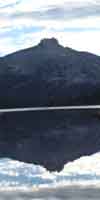
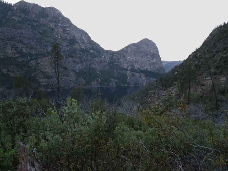
The
Furthest Western Shore
of
Tilden Lake
Looking East by the Compass, South down the Tahoe to Yosemite Trail. Macomb Ridge in furthest distance.
Trail Guide Pages
|
A Backpacking Trip Less Taken
REPORT
To Report We continued following the TYT up to a point climbing the switchbacks just West of Tilden Lake under Chittenden Peak. Now, as we can see from the picture above, we've reached Tilden Lake. Suggested Reading REVIEW Check out the lay of the land: Upper This page below continues down Tilden Canyon to Hetch Hetchy from that trail junction. We'll visit Tiltill Valley and Rancheria Falls on our long drop down the upper Western flank of the Sierra.
The four trail guide pages for the PCT & TYT leading to, covering, and departing both Tilden and Wilmer Lakes are linked to above. The distances hiking to Tilden Lake from trailheads located to the North along Highway 108, the Sonora Pass Road, are called out below. The Northern Tilden Lake trail junction located along the Pacific Crest Trail in Jack Main Canyon is pictured below.
After the PCT & TYT take their respective routes around their respective lakes they reconnect at the Southern Tilden Lake Trail junction in Tilden Canyon, located between Bailey and Macomb Ridges. A funny thing is that once we turned onto the TYT to Tilden Lake to climb out of Jack Main Canyon we are going to continue to follow this same line of trail down Tilden Canyon in this lower-upper portion of the West Flank of the Sierra, until Tilden Canyon and its Creek turn Southeast running down into Rancheria Creek. That's where our trail jumps-up onto the ridge dividing Rancheria Creek to our East from Tiltill Creek in the valley to our East. Our trail drops of the nose of this ridge into Tiltill Valley, where the line of our trail terminates by teeings-out into the trail connecting Rancheria Falls to Lake Vernon that crosses the floor of Tiltill Valley. There we take a Right to encounter Tiltill Creek and the fine campsites in Tiltill Valley along Tiltill Creek, or we cop a Left to climb for the crack in the Southern Tiltill Valley wall sitting above the descent to Rancheria Falls...
The Check out the maps. They precisely lay out the scene. The combined Southbound routes of the PCT and TYT turn Left through this junction, turning East by the compass, while our trail down to Hetch Hetchy from Tilden Lake continues straight down the mountain on its Southwestern line. The signs lay it out pretty clearly. The hump of the h The Five Canyons lay between the stem and the hump. That's the unique configuration of crestline that squeezed these awesome canyons into this tight space. We can see the Sierra Crestline bending to this shape on this To The line of our route will bring us through Tilltill Valley and past Rancheria Falls to Hetch Hetchy. This map shows the full length of the trail to Hetch Hetchy from the second trail junction South of Wilmer and Tilden Lakes: Lower
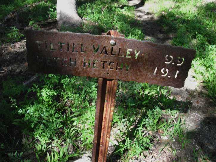
Tiltill-Rancheria-Hetch Hetchy Trail Junction
The Way Down There are very nice campsites in Tilltill Valley After spending a night at the fine campsites along Tiltill Creek we make short-work of the short climb out of Tiltill Valley preceding our next steep descent down to Rancheria Falls. Rancheria Falls also has nice campsites in an expansive grove along a gently descending run of Rancheria Creek a short distance below the Rancheria Falls trail junction. Below Rancheria Falls our descent finally moderates until we are finally down to tracing out the gentle undulations along the apron of trail wrapping around Hetch Hetchy until reaching our final destination crossing O'Shaughnessy Dam.
Jack Main Canyon The cool waters of Falls Creek during early July of 2016 brings relief from the oppressive heat while the cool breeze running with the creek makes the crossing refreshingly cool and mosquito free.
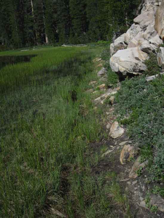
Our eye follows this delightful scene running West on a small flat/shelf for a very short distance out of the West end of Tilden Lake. The little shelf of pools and braided streams below the West shore of Tilden Lake abruptly ends where Tilden Creek disappears downward, where it begins tumbling down its steep cascading descent into Jack Main Canyon and its flow is subsumed into Falls Creek. Scrambling Around Tilden Lake There are some magnificent views to be had from Tilden Lake. We should give ourselves the time to find and experience them. A High Point Unlike our previous high points crossing Brown Bear and Bond Pass, which offered splendid but stationary views, Tilden Lake offers a wide range of rotating views from different points along its shoreline as well as from an extensive series of high observation points on the granite ridges and peaks surrounding this splendid lake. Our views narrowed, if not diminished when we stepped out of Brown Bear and Bond Passes. The opposite is true at Tilden lake. Here our views and perspectives are both expanded with each step we take around the lake, or scrambling around on the surrounding peaks, domes, and ridges. Every step opens up new views of the surrounding peaks, ridges, and Tower Peak at the top of the canyon marking the high point of the Sierra along this segment of the crestline. Impressive Chittenden Peak towers over the Southwestern end of the lake as well as Upper Jack Main Canyon. Chittenden Peak also makes up the North wall of the gap through which Tilden Creek drains into Jack Main Canyon. The feature making up the South wall of this majestic gap is a knarly knob of grand granite along Bailey Ridge. Bailey Ridge has a lot of knarly knobs and irregular granite features. That's where we are going to camp tonight.
* Summer of 2016 That was my impression of their long plans when I last encountered Trail Crew working on these trails up to and out of Tilden Lake in 2012. I got the impression that they felt the main (PCT-TYT) trails all looked good, and the crews had shifted to bringing the more remote routes through the North Yosemite Backcountry up to snuff. I would not be surprised if they run through Rodgers Canyon this year (2016), and maybe even Tilden Canyon down to Tiltill Valley over this and the the next years. By the time they run through all that, the line of the PCT-TYT will be needing attention & repairs again... |
 |
||||
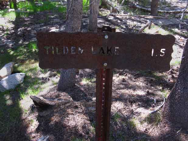
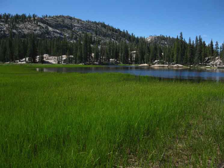
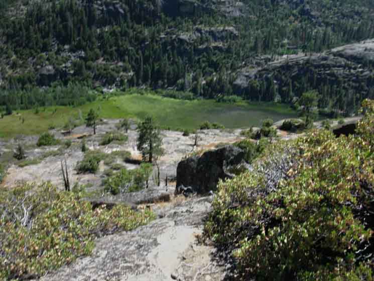
West End of Tilden Lake Tilden Creek flows out of Tilden Lake a few feet to our Left. Trail GuideINFORMATION
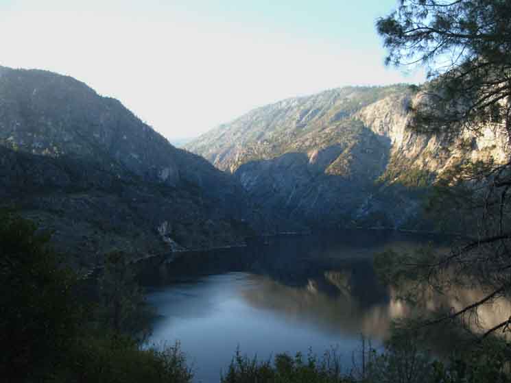
Western Edge of Tilden Lake The next trail junction reconnecting us with the Pacific Crest Trail is 3.94 miles ahead and 540 feet lower than our position above. We'll hike the next .89 of a mile along the South Shore of Tilden Lake, which we see across the lake in the distance, to where we get access to the top of Tilden Canyon. The top of Tilden Canyon lays on the far side of the nearest rock formation we see across the lake. We turn South, to our Right from the vantage point above, away from the lake when we get to the other side of that ridge arm by walking around its lakeside end. From here to there will be the length of our hike along the South Shore of Tilden Lake. |
Across the
North Yosemite Backcountry
The Backpacking Trip & Trail Culture Between This Tiltill Valley-Hetch Hetchy trail junction is 3.05 miles South of the Western-most shore of Tilden Lake pictured above. DOWN MOUNTAIN PCT-TYT Trail to Tiltill Valley This page below supplements the pages on the trail guide covering
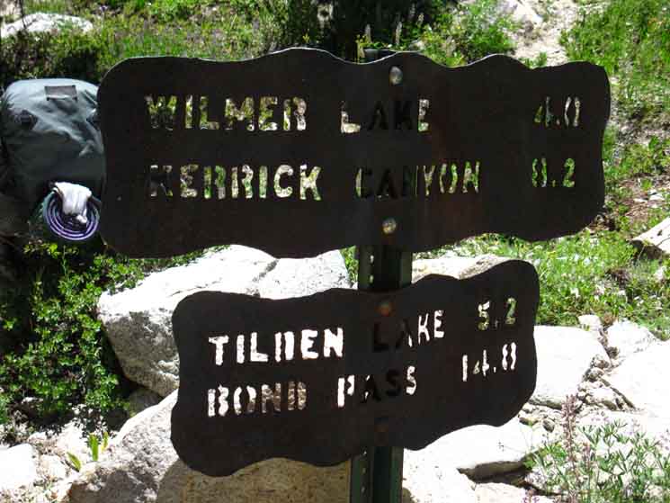
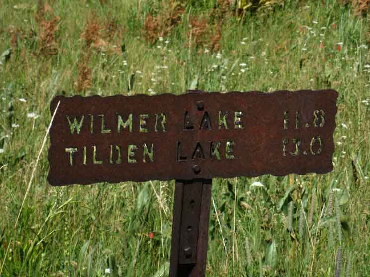
Trail Guide Trail Guide Tilden Lake & Wilmer Lake Trail Guide Pages The Southern Tilden Lake junction with the PCT sits a tenth of a mile North of the trail running down Tilden Creek Canyon to Tiltill Valley Trail GuideMaps
How to Get Here
Miles Chart of Tiltill Trail junction South of Sonora Pass & North of Tuolumne Meadows The Specific Miles
Tiltill Junction on PCT -TYT to Hetch Hetchy
The Big View
Backpacking Route Selection Via La Differencia First, Tilden Lake's higher elevations dry it out quicker both because of its more open aspect which allows the Sun and the prevailing wind (which blows through three openings along the length of its canyon, being the top, bottom, and Western) to dry it out more quickly. The location and layout of Tilden Lake suppresses mosquito activity much more than in the alcove Wilmer Lake is wedged within.
Tilden Lake Campsites Big Sky - Big Rock Tilden Lake is a sweet spot on Planet Earth.
About "Granite" Lakes It really is a delightful, cozy scene at Wilmer Lake. Relaxing, protected, and quiet. Snug as a bug in a rug. A rug made out of mosquitoes! The whole little basin holding Wilmer Lake between its surrounding rock walls sits atop a great sheet of granite holding as much water as it can. This whole area to the East of Falls Creek to Bailey Ridge where Wilmer Lake is located holds water like a cup, maintaining wet conditions and massive mosquito populations around Wilmer Lake long after the surrounding terrain has fully dried out. Wilmer Lake's surroundings hold water. Lots of water. I have always figured there's a big plate or sheet of cupped granite under this whole area that maintains a higher level of soil saturation than the surrounding areas even during the Spring Thaw, then continues to hold moisture even after the surrounding terrain dries out. Wilmer has mosquitoes well after Jack Main Canyon has dried out! There are lots of lakes like that up and down the Sierra Crest. Keep your eyes open so we can locate our campsites away from those spots that hold extra water and harbor extra mosquitoes deep into Summer. These mosquito observation and avoidance practices were necessary during this trip through the medium-heavy mosquito conditions happening during early July of 2016. Though not at their heaviest intensity, the mosquitoes were heavy and formidable during early July of 2016.
2016 PCT HIKERS I have never seen so many PCT hikers in my life, and I've spent a lot of time on the Crest Trails hiking South during "PCT time." Yet just a short distance away from the PCT at Tilden Lake there was nobody but me for the two nights I camped there. Nobody. Perfectly quiet until we return to the PCT. Eye of the Hurricane Leaving the combined route of the PCT-TYT behind us after following the TYT's annex around Tilden Lake is going to radically change our cultural and physical context with just a few steps off the main route, as it did here at Tilden Lake, but only more so.
The Last PCT Hiker Off Hiking the PCT has apparently graduated from being an expression of a sub-culture to an expression of pop culture. This is "good" if it does not draw folks to their deaths. Very Little Use Careful Observations Spots One location caused me to note the end of trail as I started a 180 degree physical search for the continuing route. The totality of the route showed signs of long periods of very light usage and only basic maintenance. I found these conditions refreshing. OFF The Review the next four maps linked to below to get a better understanding of the context of the terrain and our 5 trail options for breaking off the line of the PCT-TYT along the Sierra Crest & hiking down to the Grand Canyon of the Tuolumne. Order of Five Canyons Lower Continuing South along the PCT-TYT past Kerrick Canyon we find the next trail down to the Grand Canyon of the Tuolumne near the top of our intense climb South out of Bensen Lake's low point, where we find the two closely-spaced trail junctions under Volunteer Peak leading South off the PCT-TYT via Rodgers Canyon and Rodgers Lake, respectively, on their way to Pate Valley in the bottom of the Grand Canyon of the Tuolumne. We find a trail schematic reveals that the Rodgers Canyon and Rodgers Lake trail junctions ultimately creates a Y shape as both trails feeds the same route down Rodgers Canyon, despite their two different trails out of their closely-spaced trail junctions greeting us, after we climb to the base of Volunteer Peak hiking South towards Smedberg Lake. Rodgers Canyon to Pate Valley East of Rodgers Canyon trail junctions (located between Bensen and Smedberg Lakes) there are no more trails off the PCT-TYT down to the Grand Canyon of the Tuolumne until the route of the PCT-TYT itself turns South for its run down Cold Canyon to Glen Aulin. I consider Glen Aulin the beginning or end of the Grand Canyon of the T, depending on which way we are hiking. For me the bookends of the Grand Canyon of the Tuolumne River are O'Shaughnessy Dam and Glen Aulin. We cross what I consider to be the final of the Five Canyons where we drop into and climb out of Virginia Canyon on our way into the top of Cold Canyon. Note where the lines of Virginia and Matterhorn Canyons converge on the map below, and how the creek running down Cold Canyon flows into the top of the Grand Canyon with the Tuolumne River, rather than feeding the Canyon itself, as do the creeks running down the Grand Canyon of the Tuolumne River Aligned and Related Sierra Crestline around North Yosemite Backcountry I always need to establish a basic framework, or context. NEXT The We hike North and South in Jack Main and Cold Canyons on the ends of the Five Canyons. We hike East & West through the Canyons between Jack Main and Cold Canyons. The route of the PCT-TYT across the North Yosemite Backcountry traces out its route about six miles below the line of the Sierra Crest as it crosses the upper reaches of these massive Five Canyons. The total length of these canyons draining the Western Flank of North Yosemite ranges around 30 miles between Crest and Canyon as they all flow into the Grand Canyon of the Tuolumne River. It's a Good Thing CLICK-CLICK Clicking the routes and regions on the 30 minute large-scale maps links to the detailed maps for those positions clicked. Clicking the labels on all the maps brings us to its adjacent maps. Why This close-in spacing demands a much higher energy output to maintain pace and daily distance than the rest of the trail South to Mount Whitney and the trail North to Lake Tahoe. This difference is noticeable, and draws the hiker's attention to this demanding terrain, which inspires us to find words that characterize its uniqueness. Thus we hear the terms, "The Five Canyons," "The North Yosemite Backcountry," and "The Washboard" spoken with respect by informed backpackers.
Hiking the line of the PCT-TYT across the North Yosemite Backcountry runs us across the top of the Western Watershed of the Grand Canyon of the Tuolumne River from the time we enter the North Yosemite Backcountry crossing Bond Pass into Jack Main Canyon all the way down to our long descent down Cold Canyon to Glen Aulin. Yes they are. The terrain upstream of Glen Aulin also feeds into the Grand Canyon, but that water is coming down from Tuolumne Meadows, and all the terrain wedged in between the Western Flanks of the Sierra and Eastern Flanks of Cathedral Ranges wrapping around Tuolumne Meadows and all the way South to Donohue Pass. It is hard to get a "feel" for such a long and difficult section of trail. Keep on Trucking This particular trip is one of those times to explore the next of the Five Canyons, this time the trail from Tilden Lake through Tiltill Valley to Rancheria Falls and down to Hetch Hetchy. Is it time for you to begin exploring this remote terrain? I've also hiked in and out of the North Yosemite Backcountry through Twin Lakes in the Hoover Wilderness, but I don't think I ever took any pictures. NEXT
|
Down Tilden Canyon On the PCT-TYT Trail Options
1 Continue scrolling down page below
6
O'Shaughnessy Dam
|
Hiking South
off the
PCT-TYT
We begin hiking South off the PCT-TYT across a mile & a half of flattish-gently descending valley floor centered with fine green meadows spotted with crystal blue lakes surrounded by fingers of encroaching dense forest thinning as each successive species reaches higher and higher into harsher conditions as they climb the West Flank. We're still up in lodgepole land up here. We descend gently about a mile and a half South from the Tiltill Junction to the point we begin climbing for the trail junction leading West to Jack Main Canyon. But first we descend past a couple of lakes, long stretches and spots of meadow composing a series of idyllic scenes. |
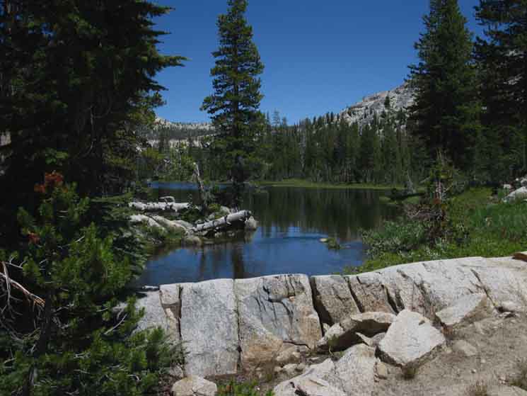
First Lake South
of
PCT-TYT
Tiltill to Hetch Hetchy
Trail Junction
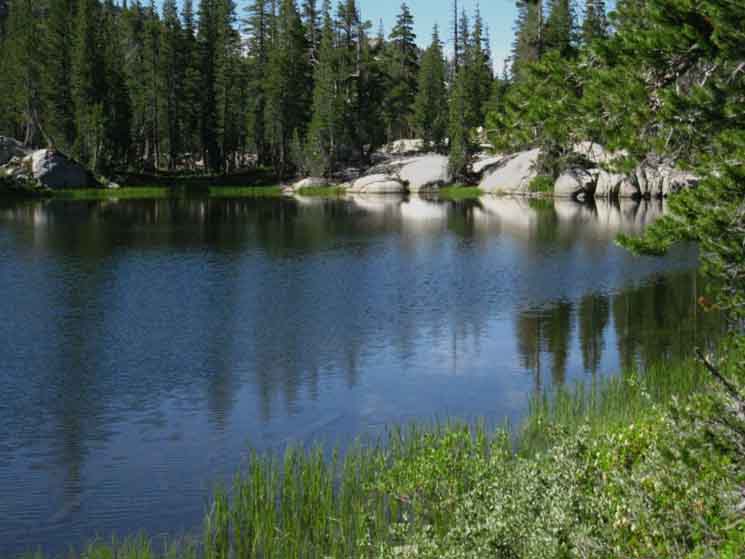 |
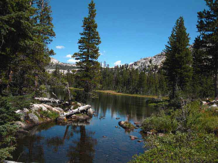
Descending gently Southbound down Tilden Canyon to the uppermost lake in Tilden Canyon hiking below the Tahoe to Yosemite and Pacific Crest Trails. |
Ponds
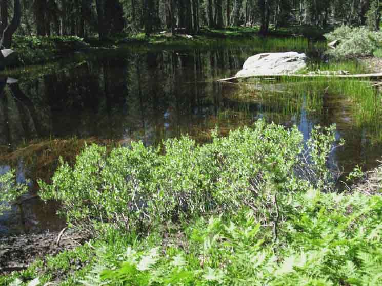 |
Pond between Lakes in Tilden Canyon below PCT-TYT. |
Across A Granite Plate
 |
Our trail threads between meadow, forest, and rock approaching the second and third lakes as we hike South through Tilden Canyon below the PCT-TYT trail junction. |
Third Lake South
of
PCT-TYT
 |
The third substantial lake about a mile South of the TYT-PCT.
|
South Along the Shore of the Third Lake
 |
Trail along shore of third lake South of PCT-TYT in Tilden Canyon. |
South We climb to our Southwest out of the valley we see below, which is turning Tilden Canyon Creek to the Southeast, through a nifty gap into some nice terrain under Tiltill Mountain. Check your Hiking Map! |
Way Down There
Looking Southeast
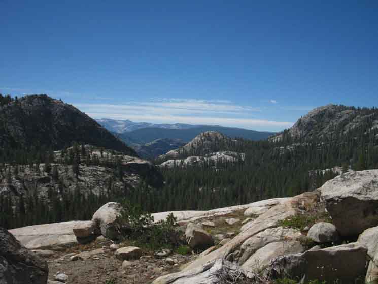 |
Looking Southeast as we climb approaching the junction with a trail leading West to Jack Main Canyon. We are looking across and out of Tilden Creek Canyon into and across next canyon to the West, that holding Rancheria Creek, just below where it flows out of Kerrick Canyon. Just below our position Tilden Canyon Creek turns and runs Southeast to flow into Rancheria Creek. It is bending East out of our sight under the dense forests we see down there. Beyond Rancheria Creek's canyon (I figure it lays between the two domes in the middle of the image, being the near light-colored dome and the most-distant faint tiny gray dome to its Left) we can see the very faint nose of Rodgers Canyon, (to the left and behind the most distant center-Left gray dome) and beyond that nose we see the Southern Wall of the Grand Canyon of the Tuolumne making up the huge dark ridge undulating across the middle distance. I figure White Wolf is located on the Right side of that dark ridge. |
Looking Back,
Northeast
Trail Junction |
to
Jack Main Canyon
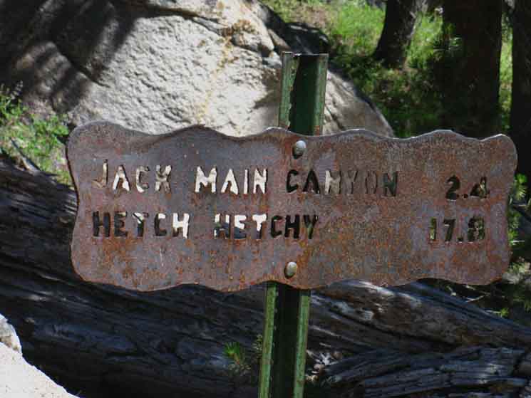 |
Trail West Trail 2.4 miles West to Jack Main Canyon from Tilden Canyon. 17.8 to Hetch Hetchy via Jack main Canyon. We are hiking South to Hetch Hetchy, but by continuing down our present canyon, rather than switching over to Jack Main Canyon to our West. Check out where this trail intersects with Jack Main Canyon. |
Climb West
to
Lower
Jack Main Canyon
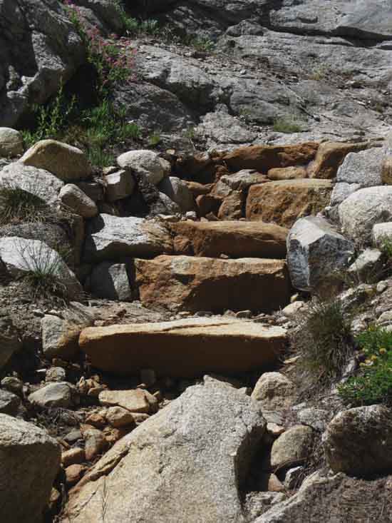 |
Rock Stairs Stairs West out of Tilden Canyon to Jack Main Canyon. |
| Trail Junction
2.1 miles South
17.0 to Hetch Hetchy
|
South
to
Grand Canyon of the Tuolumne
 |
| Trail leading South to Hetch Hetchy via Tilltill Valley. |
| Trail Junction Back to Tilden Lake |
to
PCT & TYT
ROUTES
 |
Trail North, back the way we came to the PCT-TYT junction to the South of both Tilden and Wilmer Lakes. |
Trail
We push up through a nice gap to find ourselves in another gently declining mix of meadow, rock, and forest for maybe two miles, to where the descent steepens considerably and the heat rises significantly with every foot we drop. |
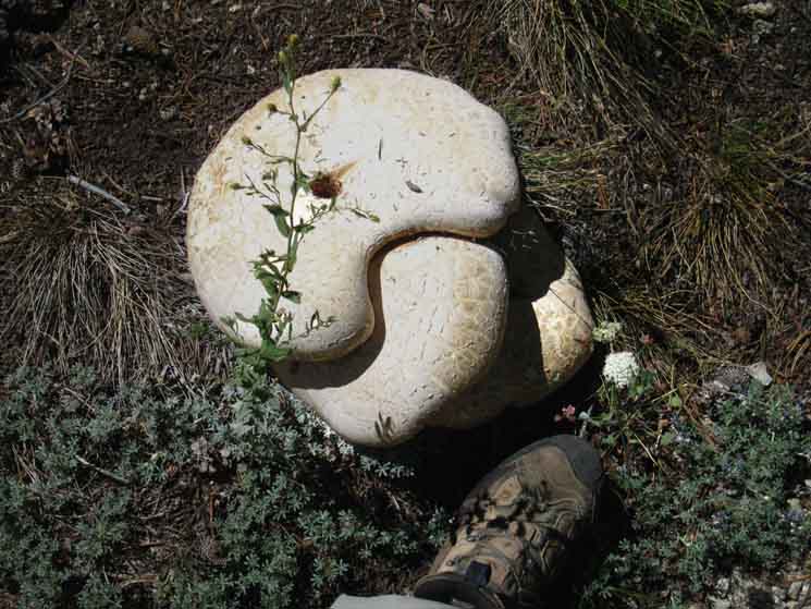 |
This Giant Fungus dwarfs my foot. That is not a mushroom steak, it is a veggie "side of beef," if it was edible. I have no idea. I observe, but not taste, the fungus. |
Found Pond
 |
Hidden Pond off the trail as we descend. I needed water, and somehow I knew that this pond was here, though I was not consulting my map, and can't tell you exactly why. It looked to me like there was water off to my Right, West, so I figured I'd push West off the trail for a couple of hundred yards to see what was making me feel wet. This was it. Not the best water, but OK. |
Meadow and Forest
Lushness
 |
| Last length of great meadow across fairly level descending terrain before our descent turns very steep. |
Hot Dry Switchbacks follow |
First Glance Hetch Hetchy
 |
First view of Hetch Hetchy from above Tilltill Canyon. Our descent had begun to steepen, now we are entering switchbacks. We can see the higher elevation lodgepoles have given way to Jeffery Pines, and the red mountain heather to manzanita, all physical signs of the increasing heat we feel. |
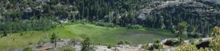
Tiltill Valley
 |
Descending into our first view of Tilltill Valley. Note the lack of a Pond on the Right side of the Valley as indicated by the maps, or a creek feeding the pond. The shot above was taken in July of 2016, after a weak Winter and four years of hard drought conditions preceding a gradual drying out over the past thirty years. The trail lands in the furthest-Left corner of the valley floor, just a bit out of the Left edge of the image. Tiltill Creek lays beyond the far-Right edge of the image, across which are sets of nice campgrounds. RATTLERLAND Rattler was real fat, short and stubby. Rattler noted my observing him, but did not respond in the smallest way. I was aware of Rattler's presence curled up in a small depression in the middle of a path leading from my campsite to Tiltill Creek, so I did not need to, or accidentally approach him. Rattler noted me observing, I spoke a few sweet words, and Rattler appeared inclined to keep its overnight sleeping spot rather than relocate so late in the day. We certainly are in Rattler Country, so our trail perception is now going to add serious Rattlesnake Objective Threat Observation to our normal list of hiking cautions. Eyes always Open, now more so. We will double our attention to the ground and the things blending into it. Rattlers are named for how they threaten away interlopers, but they cannot warn us away when they are asleep, so we will make sure we don't wake any sleeping Rattlers on our way through the hot zone. |
Meadow
on
Floor of Tiltill Valley
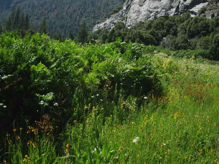 |
Divine massive clumps of dense vegetation, especially these great "rafts" of ferns complimented by thick meadow grasses and trimmed around the edges of the meadow by thickets of dense reeds. The vegetation was dense when I hit the floor of Tilltill Valley July 16 of 2016. I had to first locate the line of the trail through the dense grass, ferns, and reeds. Then I had to bust through, while being careful to stay on the line of the trail! |
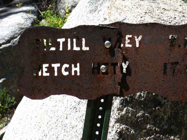
Tilltill Valley Trail Junction Tiltill Valley We've hiked We Face |
to
Tilden Canyon
 |
The trail sign marking our trail, pointing back the route we entered Tilltill Valley. Hiking this route entails making the steep climb up the West Flank of the Sierra Crest out of Tilltill Valley that we just now finished descending into on our way down from Tilden Lake. All of the routes climbing from Hetch Hetchy to the Route of the PCT-TYT |
to
Jack Main Canyon
West
to
Campsites along Tiltill Creek
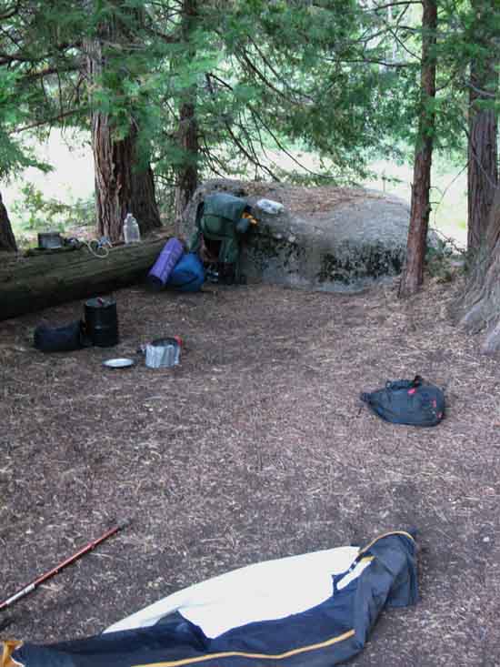 |
One of the set of very nice campsites in Tilltill Valley. |
to
Main Tiltill Trail Junction View North
across
Tiltill Valley
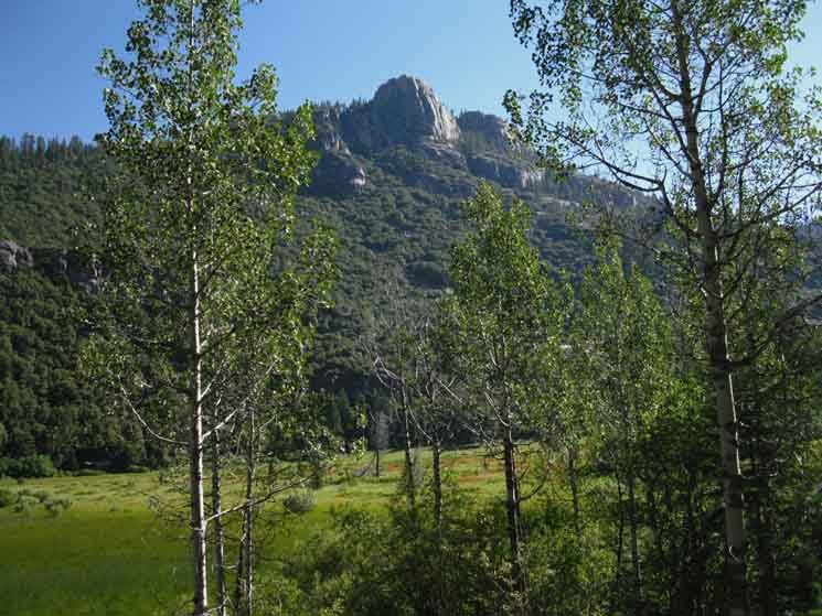 |
Reaching the South fringe of the meadow in the bottom of Tilltill Valley we turn to look Northeast across the valley at Peak 7585. Our trail down from Tilden Lake came around the backside of that feature. |
above
Hetch Hetchy
Rancheria Falls Trail Junction Rancheria Falls 12.6 miles from PCT-TYT 6.5 miles to Hetch Hetchy Trailhead |
back to
Tiltill Valley
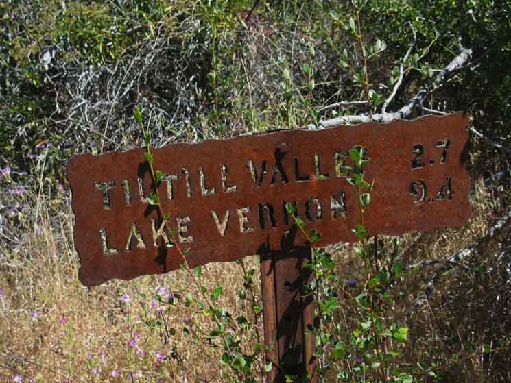 |
The Rancheria Falls trail junction. The sign above marks the trail back up to Tilltill Valley. |
to
PCT & TYT
Southwest
to
Hetch Hetchy Trailhead
 |
End of the trail at O'Shaughnessy Dam. |
Rancheria Falls Trail Junction Just about 300 yards South of the Rancheria Falls trail junction we will notice a long, wide, densely forested flat spot, well, a gently descending strip of terrain opening up between us and Rancheria Creek, which is about a hundred and fifty yards to our Left, to the East of the trail. These are the location of the last campsites before reaching the trailhead at Hetch Hetchy. There are lots of campsites here, and a long run of the river along a shallow descent, which makes exploring the rocky run of Rancheria Creek here easy. |
back to
Campsites below Rancheria Falls
along
Rancheria Creek
 |
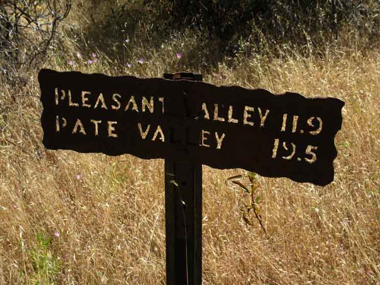
Looking back at the location of the campsites below the Rancheria Falls trail junction, at where Rancheria Creek begins to descend more rapidly. The trail leading Northeast for Pleasant and Pate Valleys climbs over the saddle visible along the Left end of the ridgeline. That is just the beginning of a long climb to the Sierra Crest, if so desired... The flat with campsites running along it is located above the visible top of the whitewater. |
to
Hetch Hetchy
 |
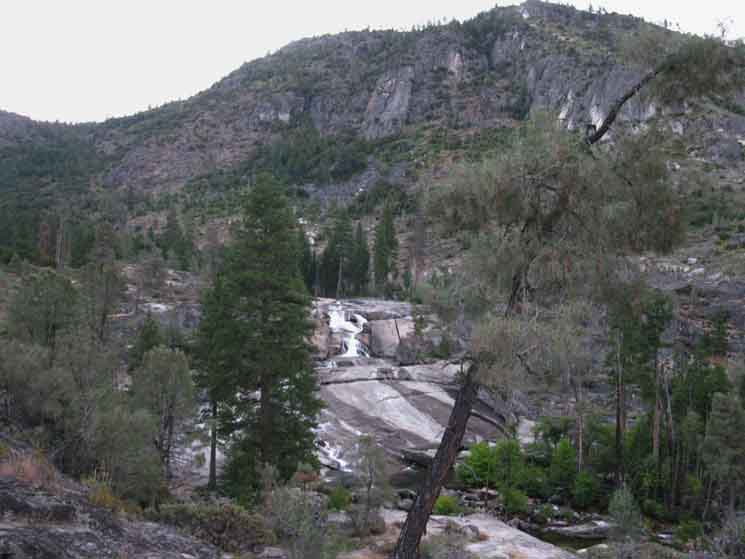
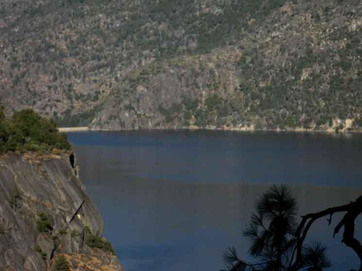
A view of Hetch Hetchy descending from Rancheria Falls. |
Bridge
over
Tiltill Creek
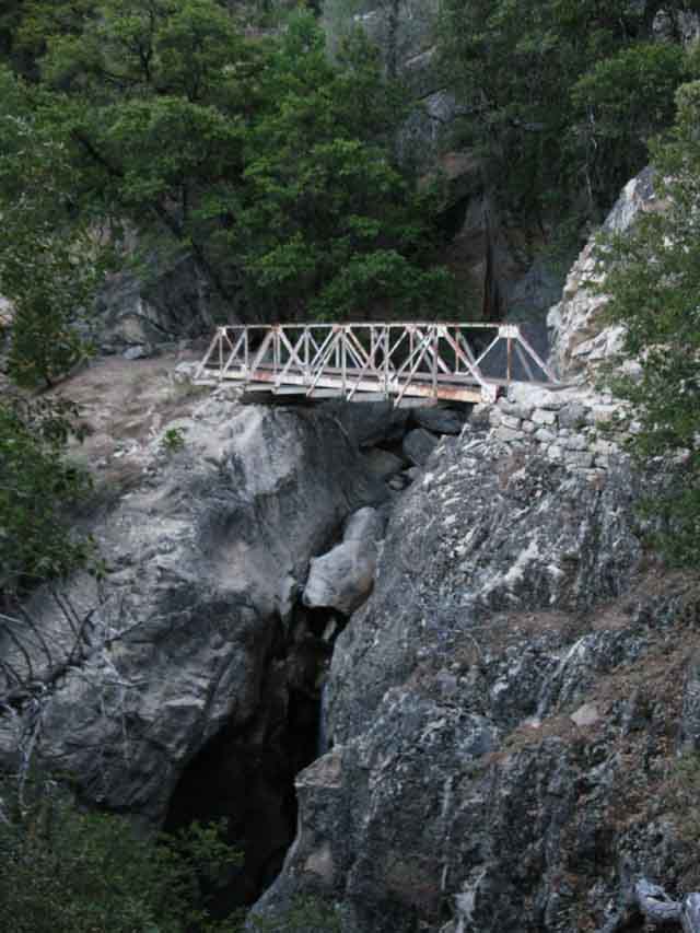 |
The bridge over Tilltill Creek. |
Camping
Limit
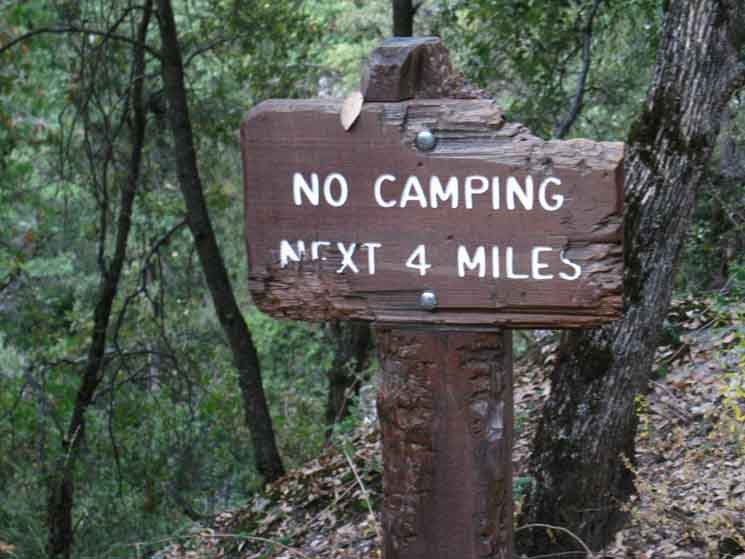 |
Yosemite has stated distances prohibiting camping from every trailhead. This looks to mark the last four miles of no camping zone to the end of the trail at Hetch Hetchy. The fact of the matter is that the nearest campsites to the Hetch Hetchy Trailhead are at Rancheria Falls. |
Hazy Sunrise
 |
Myself and first light both moving rapidly down towards the surface of Hetch Hetchy. The evening cool is rapidly dispelled by the approaching Sun, way down here at the 3797 foot elevation on the surface of Hetch Hetchy. Yosemite Valley and Hetch Hetchy are the lowest elevation locations I hike in. I know of no other places where deep mountain granites go so low in elevation. Nowhere. I was racing the light of the rising Sun, both of us descending the walls of the Grand Canyon of the Tuolumne River to the trail wrapping around the reservoir. |
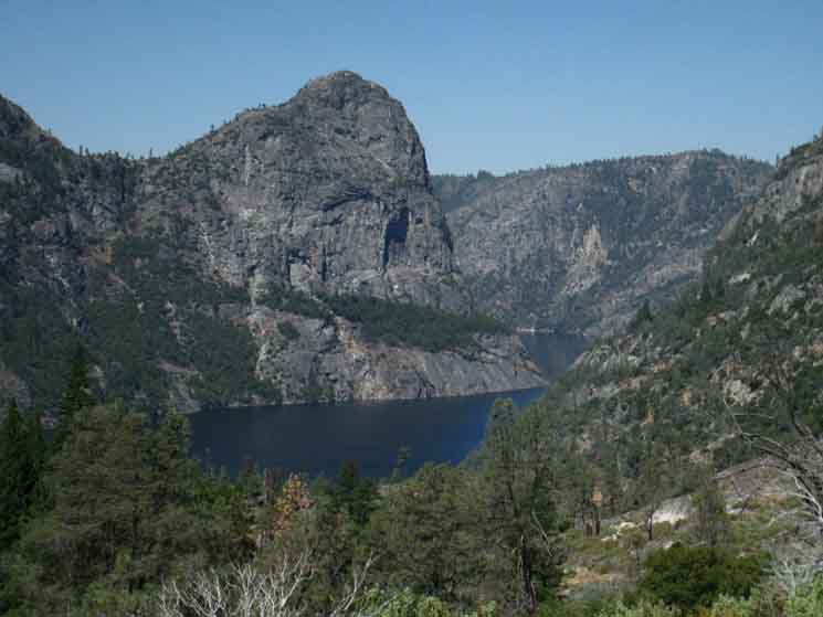
Kolana Rock
Eclipses O'Shaughnessy Dam
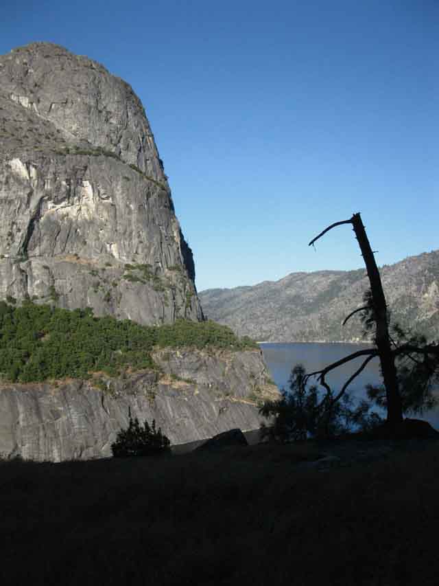 |
Approaching Lake Level and our second view of O'Shaughnessy Dam beyond the bulky base of Kolana Rock. |
Kolana Rock
Eclipses O'Shaughnessy Dam
Backpackers
at
Wapama Falls Triple Bridges
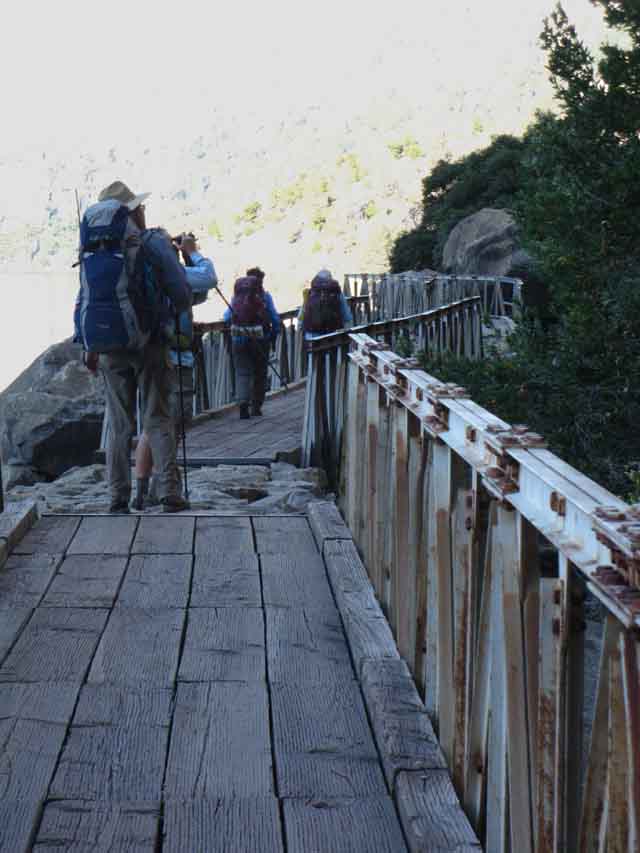 |
Wapama Falls Triple Bridge. My physical status was completely degraded, causing me to defer my normal tasks of recording backpacker's experiences along the trail. I was barely managing my own affairs, let alone properly recording and reflecting other's! |
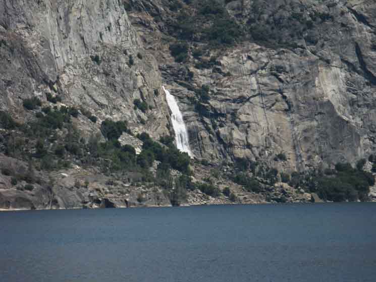
Wapama Falls
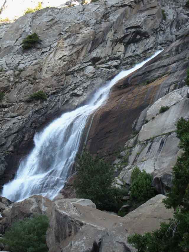 |
| The bottom section of Wapama Falls. |
First or Last Or Both Setting the Scene Returning to CIV Arrrg It is the human thing to do. Our next landmark of importance is the first trail junction North of the O'Shaughnessy Dam. I would call this the
Two Trails First Trail Amazing Parallel Graces The Variable Turnaround Points Continuing up Jack Main Canyon brings us to our next turnaround option at the trail junction leading East to Tilden Canyon, where we can begin descending to Tiltill Valley. Climbing further up Jack Main Canyon beyond the trail to Tilden Canyon brings us to another trail East to Tilden Canyon, this time being the route of the Pacific Crest Trail turning East to climb out of Jack Main Canyon to Tilden Canyon via Wilmer Lake. The X Axis Variable Loop Diameters We can widen our Hetch Hetchy Hiking Loop. We can expand the X Axis of our hike by following the Southbound Pacific Crest Trail East from Jack Main Canyon to the canyon we selected for our return route to Hetch Hetchy, again selecting the turnaround point that best suites our endurance, goals, expectations, or even our time limits. Pick Your Pleasure
|
Hetch Hetchy Trailhead OUTBOUND HIKERS O'Shaughnessy Dam
|
TRAILHEAD MILES
NORTH
(On the Trail Pictured Below)
VIA
MORAINE RIDGE
UP
JACK MAIN CANYON
|
*Note the route from KM to Hetch Hetchy via Tilden Lake and Tilden Canyon
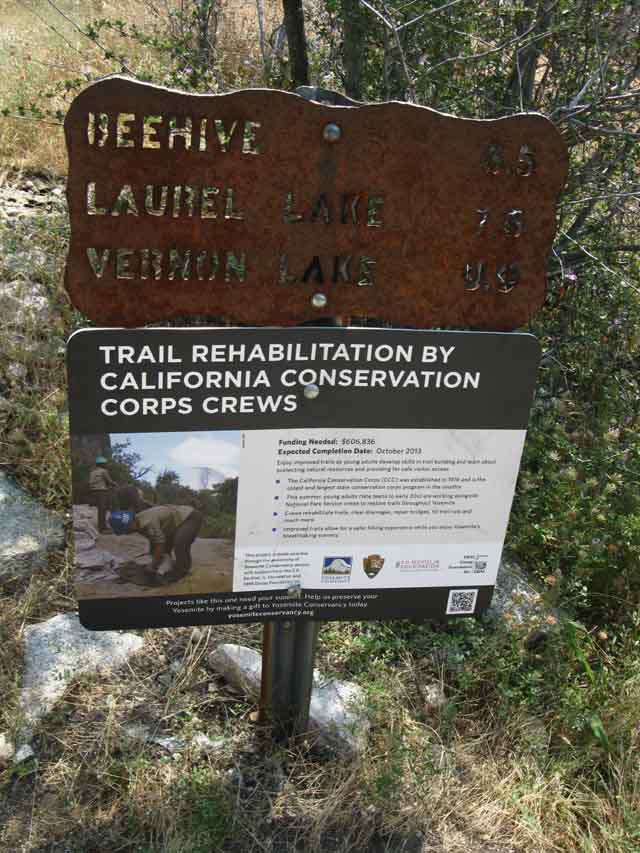 |
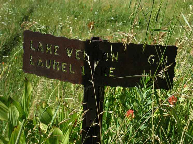
Trail junction up the monster climb onto Moraine Ridge and then into the bottom of Jack Main Canyon. Beehive 6.5 miles Laurel Lake 7.6 miles Vernon Lake 9.9 miles |
Hetch Hetchy Trailhead OUTBOUND HIKERS O'Shaughnessy Dam 6.5 miles to Rancheria Falls |
TRAILHEAD MILES
NORTHEAST
(On the Trail Pictured Below)
VIA
Rancheria Falls and Tiltill Valley
UP TO
PCT-TYT
TRAIL JUNCTION
IN
TILDEN CANYON
|
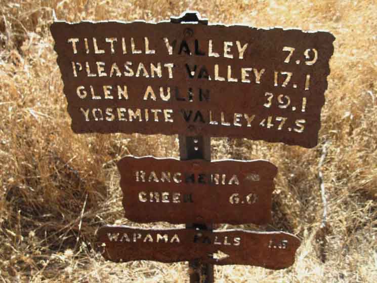 |
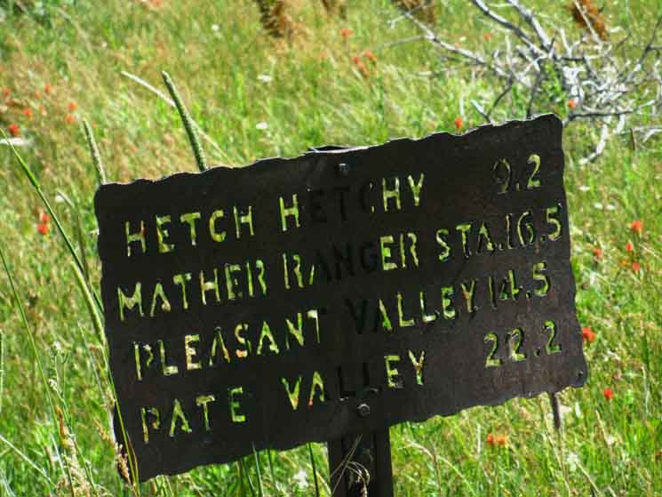
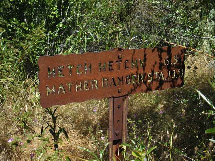
HIKING Our trip hiking South-Southwest off the PCT-TYT through Tilden Canyon to Tiltill Valley and Rancheria Falls on our way here to Hetch Hetchy is about over I've got to note the steel trail sign in Tiltill Valley reads out the distance to Hetch Hetchy at 9.2 miles, while the sign above reads it out at 7.9 miles. Outward Bound We can ascend from here to three different points along the combined routes of the TYT-PCT across the North Yosemite Backcountry. These are through Tilden Canyon Creek, into Kerrick Canyon at its PCT-TYT fording point, or up through Rodgers Canyon. Taking the route to Rodgers Canyon brings us through Pleasant Valley, where we can either continue up to the PCT-TYT or drop down to Pate Valley on the floor of the Grand Canyon of the Tuolumne above the top of Hetch Hetchy Reservoir. See the Grand Canyon of the Tuolumne map for a good overview of all these North Yosemite backpacking trips. |
O'Shaughnessy Dam
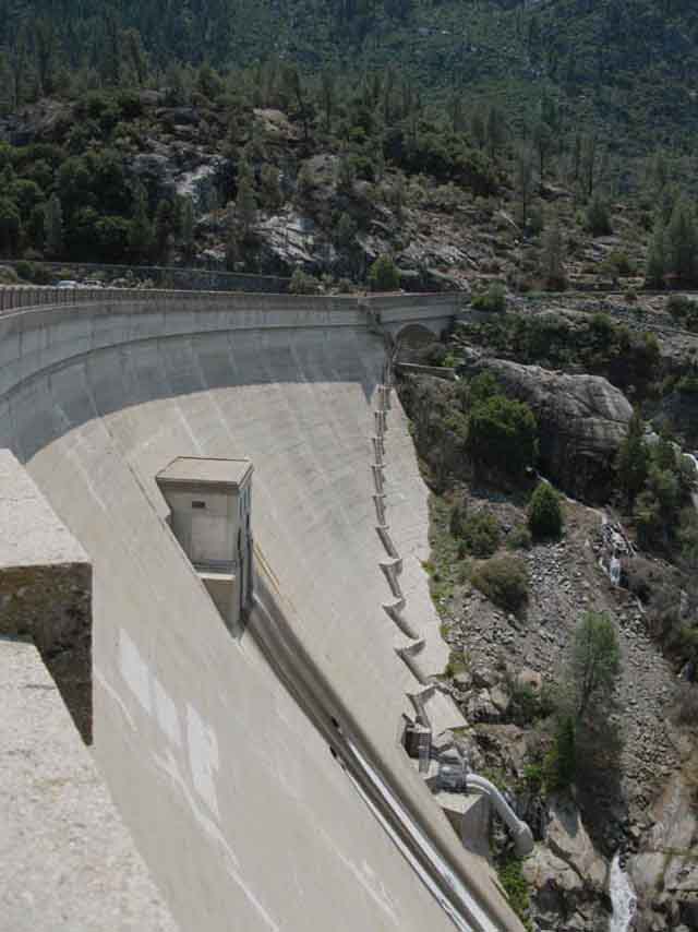 |
Face of O'Shaughnessy Dam. |
Hetch Hetchy
&
O'Shaughnessy Dam
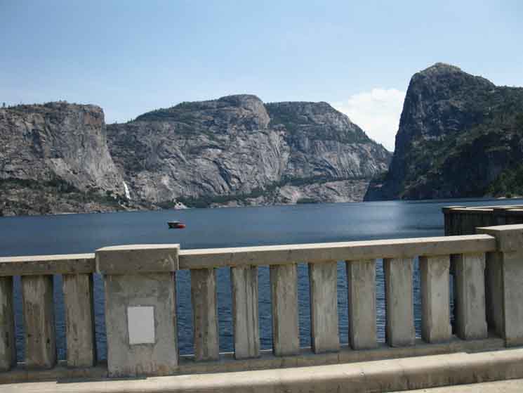 |
| View of Wapama Falls and Kolana Rock across Hetch Hetchy from O'Shaughnessy Dam. |
Wapama Falls
 |
Wapama Falls from O'Shaughnessy Dam. |
Associated
Trail Guide Pages
|
Hetch Hetchy Roadmap
Road Maps specifying locations of the endpoint of our backpacking trip to Hetch Hetchy in relation to Mather, Highway 120, Crane Flat and Tuolumne Meadows. |
Last page: Report: PCT Hikers North Yosemite Next page: Tuolumne Meadows
2016 |
|||||||||
North Yosemite Backcountry
The A 2016 Visit Associated Trail Guide Pages
|
Backpacker ForumsHave a great Sierra Nevada trip or story to relate? A fine piece of gear? Or gear that failed?Post it onTahoetoWhitney.Org Become a MemberIf you have experiences, comments, questions, or pictures and videos about the trail between Lake Tahoe to Mount Whitney, post up here.All backpackers can comment. Backpacking Trails Forum
|
Trailhead
Contact
Alex Wierbinski

Backpacking Lake Tahoe to Mount Whitney
Your guide to the High Sierra Crest, including the Tahoe to Yosemite, Pacific Crest, and John Muir Trails
