


Jack Main Canyon to Virginia Canyon
HIKING MAP
including
The Grand Canyon of the Tuolumne River
Running Parallel With The
Pacific Crest and Tahoe to Yosemite Trails
North Yosemite National Park Hiking Map:
Backpacking Map
The North Yosemite Backcountry, the "Five Canyons of North Yosemite," AKA, The "Washboard"
Two
30 minute USGS Backpacking Maps

| PCT-TYT Yosemite MAPS |
TRAIL GUIDE INFORMATION |
Tahoe to Whitney INDEXES |
More TYT-PCT-JMT Miles and Elevations |
7.5 Map Series |
Weather, Map Data | |||||||||||||||||
| PCT MAPS INDEX Sonora Pass to Tuolumne Meadows |
30 min MAP NORTH Sonora Pass to Bensen Lake |
30 min |
Miles and Elevations Sonora Pass to Tuolumne Meadows |
Trail Guide |
Section INDEX Sonora Pass to Tuolumne Meadows |
Trail Guide INDEX Tahoe to Whitney |
All Miles INDEX Tahoe to Whitney |
All MAPS Tahoe to Whitney |
Ebbetts Pass to Sonora Pass |
Sonora Pass to Tuolumne Meadows |
Tuolumne Meadows to Yosemite Valley |
Tuolumne Meadows to Reds Meadow |
Section MAPS Sonora Pass to Tuolumne Meadows |
All MAPS Tahoe to Whitney |
PERMITS |
RESUPPLY Kennedy Meadows -- Tuolumne Meadows |
||||||
FULLY LINKED
TOPO HIKING MAP
Click the Map
for
DETAILED HIKING MAPS
Backpacking Map
Pacific Crest Trail & Tahoe to Yosemite Trail
across the
North Yosemite Backcountry
"Washboard"
North: Sonora Pass to Bensen Lake Map Click Black Dots South: Virginia Canyon to Tuolumne Meadows Map
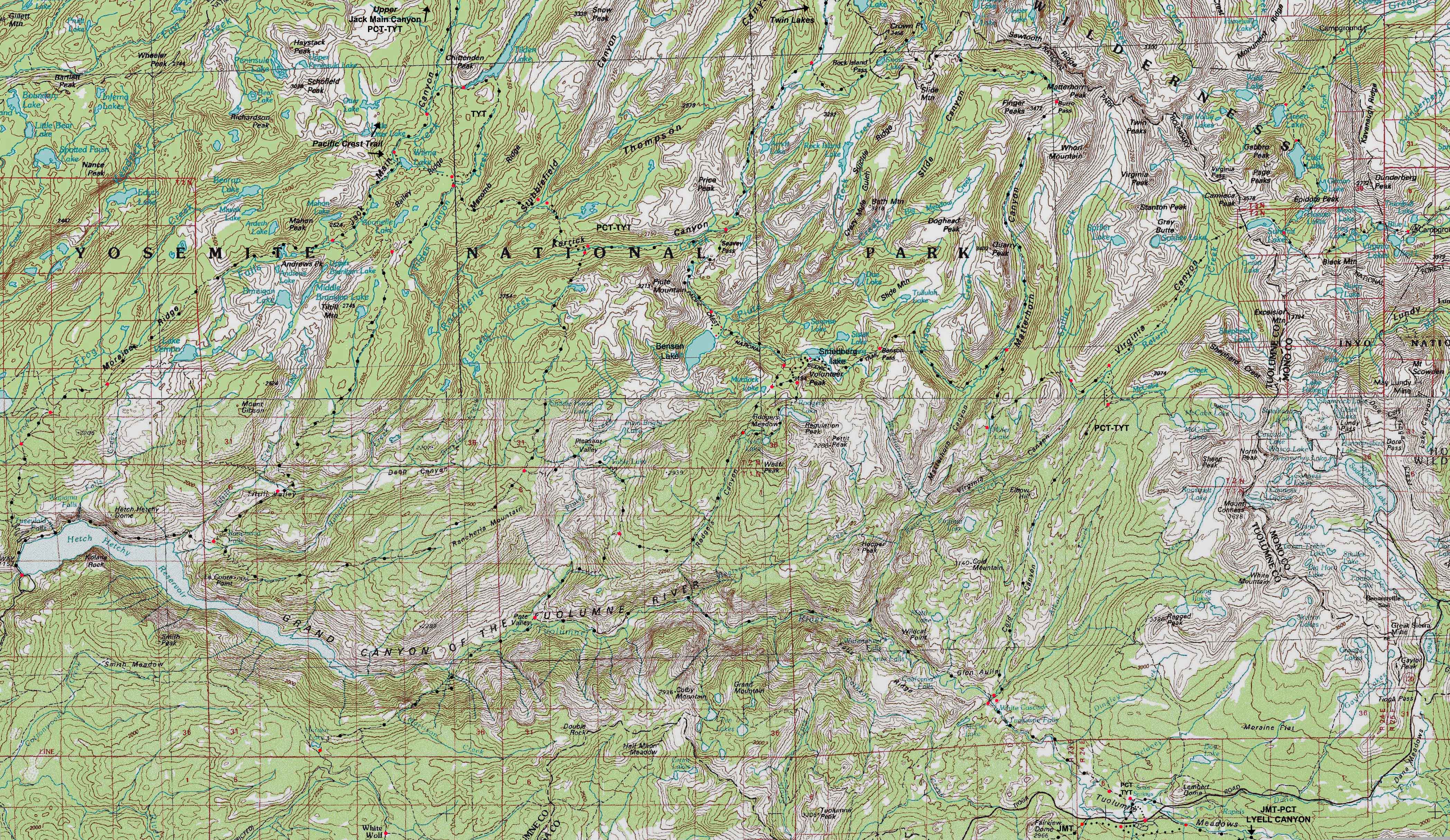
North: Sonora Pass to Bensen Lake Click Black Dots South: Virginia Canyon to Tuolumne Meadows
Location Notes |
Main Features Beyond Three Lines of Influence These three lines of the Sierra Crest, the line of our trail, and the line of the Grand Canyon of the Tuolumne River all run roughly parallel to each other. The lines of the Sierra Crest, the PCT-TYT, and the Grand Canyon of the Tuolumne River are strongly linked together by the series of massive ridges and deep canyons running South by the compass down the Western Flank of the Sierra Crestline from the Sierra Crest into the Grand Canyon of the Tuolumne River. The map above depicts our PCT-TYT trail across North Yosemite, the whole length of the Grand Canyon of the Tuolumne, and the majority of the Sierra Crestline wrapping around it, all tied together by the fifteen to twenty mile lengths of the canyons and ridges that tie them all together into a logical zone of exploration. This overview shows us that we have a series of 4 trails running down the canyons between the ridges that connect the PCT-TYT to the Grand Canyon to potentially explore. Despite the abundance of trails running down-mountain, we only have two trails climbing over the Sierra Crest from the line of the PCT-TYT. Our only other trail to the East Flank off the line of the TYT-PCT exits the upper section of Virginia Canyon for trailheads at Green Creek or Virginia Lakes. The reasons for this large scale regional map are twofold: Bensen Lake Loop Wide and Narrow
Hoover Wilderness The Virginia Canyon to Tuolumne Meadows 30 min map also depicts the Lundy Canyon and Saddlebag Lake Trailheads accessing the Harvey Monroe Hall Research Natural Area and the East Flank of Mount Conness. Although the Lundy Canyon and Saddlebag Lake East flank trailheads link with each other, they don't offer trail access to our PCT-TYT through-route running down Cold Canyon. Click The Maps |
North: Sonora Pass to Bensen Lake Click Black Dots South: Virginia Canyon to Tuolumne Meadows
Hetch Hetchy Roadmap
|
Tuolumne Meadows Roadmap
|
Mapping, Mileage, |
|
The elevation information below highlights the visual presentation of this precipitous terrain above. We are hiking through the Southern Half of the well-named "Five Canyons of the North Yosemite Backcountry," also know as "The Washboard." The elevation figures below indicate our route rapidly ascends and descends a series of closely spaced High Sierra ridges just below the Western flank of the Sierra Crest. This segment of our trail is composed of harsh climbs and steep descents, at least until we hike South into the bottom of Virginia Canyon. Though we have another climb South up to the top of Cold Canyon, the terrain is noticeably moderating, and once we reach the top of Cold Canyon we face a long downhill hike to Glen Aulin. Click the red dots to see the trail guide entry for that location, and click the main route of the combined PCT-TYT for the underlying highly detailed 7.5 minute topo map. |
USGS Topo Hiking Maps Bridgeport Calif, 30x60 Topographic Maps, 1985 Yosemite Valley, Calif, 30x60 Topographic Maps, 1976
Compass Offset
scale Contours
Backpacking permitting authorities:National Forest, Northeast of Yosemite Wilderness Area Toiyabe Ranger District |
North: Sonora Pass to Bensen Lake Click Red Dots South: Virginia Canyon to Tuolumne Meadows
| PCT-TYT Elevations |
FORUM | ||
Hetch Hetchy Surface Wilmer Lake Seavy Pass: 9120 feet Bensen Lake: 7581 feet Bensen Pass: 10160 feet Matterhorn Canyon: 8480 feet High Point South of Miller Lake: 9560 feet Virginia Canyon: 8560 feet |
Trail Guide, Section |
||
Map Credit |
||
U.S. Geological Survey, Department of the Interior Download all the maps you need for FREE! Move the Map to the Sierras. Select size of Maps you wish to locate. Click "Mark Point" on map to see the USGS map grid of the selected map scale. USGS Topographic
|