Killer Sunset at The Sisters near Carson Pass
Lake Tahoe to Mount Whitney: Crown Jewel of the Pacific Crest Trail
Need a Map? Lost Al near Lost Keys Lake
Emigrant Wilderness under Tropical Thunderstorm, September.
Round Top Lake
Whitebarks and Grizzly Peak in Emigrant Wilderness under Tropical Clouds during September 2013
Lost Keys Lake
 

Lake Tahoe to Mount Whitney
Trail Guide, Magazine, & High Sierra Backpacker's Trails and Topics Forums


HIGH SIERRA BACKPACKER'S
Calendar


October
2018


Important Seasonal Happenings, Transitions, Events, & Dates
for
High Sierra Backpackers


Road Conditions, Resupply, Seasonal Transition Concerns, Permit Dates, Weather, Water, and Mosquitoes


Last Year
2017


THIS YEAR
News, Views, & Issues
October
2018
High Sierra
News
AUGUST
2018
Backpacker
Alerts
2018
Natural Meltdown
High Sierra
Backpacking
TOPICS
High Sierra
Backpacking
TRAILS
High Sierra
Backpacking
FITNESS
High Sierra
Backpacking
SKILLS

High Sierra
RESUPPLY
High Sierra
PERMITS
High Sierra
WEATHER
High Sierra
Trail
GUIDE
INDEX
High Sierra
Trail
MAPS
INDEX
High Sierra
Trail
MILES
INDEX
Download
FONT


2018
High Sierra
Backpacking Calendar

January         February         March         April         May         June

July         August         September         October         November         December


INDEX


October
2018

Last Week in September

Week 1

Week 2

Week 3

Week 4

Week 5

TRAILHEAD

Last Year


October 2018
Black Giant rises in pinks of setting sun beyond Muir Pass with Wanda Lake shimmering in the foreground

Muir Pass and Black Giant beyond Wanda Lake.
The Black Giant backdrops Muir Pass from our campsite on a rise above Lake Wanda.

Just look at that! Tomorrow we scramble.

Trail Guide           Map           Miles and Elevations: Not yet online

October 2018

Top of Page

January       February       March       April       May       June     July     August     September       October       November      December
Sunday Monday Tuesday Wednesday Thursday Friday Saturday

October
Dangers
FIRE & ICE

FIRE

Last Year October started Warm and heated up into the mid October Firestorms that burned up Napa & Santa Rosa.


ICE
Every couple of years late season backpackers are surprised by Early-Season Snow, Snowstorms in October!

Two feet of unexpected snow strands backpackers.
ARE WE READY for the UNEXPECTED?


How's this Year look in the context of Last Year?
REALLY GOOD!!

October 2017


Entering October 2018
We've cooled from Mid-September through Early October, giving the firefighters a much needed break. Early Oct Tropical moisture is lowering odds of Diablo Wind-fired fires, but we're not out of the woods yet.


2016
Was one of those years.
How's 2017 working out?


LAST MONTH

NEXT WEEK


More
High Sierra
Backpacker Information

Guide Trailhead

Guide Index

High Sierra Magazine

HIGH SIERRA TRAILS FORUMS

HIGH SIERRA TOPICS FORUMS

GEAR FORUMS

GEAR LIST

September 26


September 27


September 28


SEE THE LATEST
HIGH SIERRA NEWS


NEW
Temp & Snow Tables by Watershed and Highway Corridor


Also See
All High Sierra Snowpack Data.


Date-Adjustable High Sierra Snowpack Status


Also See
All Snowpck Data on Weather Page


September 29


LAST MONTH

NEXT WEEK


TOP

Sunday Monday Tuesday Wednesday Thursday Friday Saturday

September 30


2017


1

HUMID


2018 WATER YEAR
Another Climate Changing Warmer & Drier Year


SEE THE LATEST
HIGH SIERRA NEWS


NEW
Temp & Snow Tables by Watershed and Highway Corridor

Scroll down to see the...


Also See
All High Sierra Snowpack Data.


Date-Adjustable High Sierra Snowpack Status


2017

Review First Week of Oct

2

HUMID

TROPICAL DOWNPOURS!
Northwestern-Northern California
Oct 2 early AM


First Rain Since May for Most of California


Not much precip, but what did come down fell hard & fell fast!


Past Rainfall

Rain Forecasts & Models

High Sierra Weather Page


3

HUMID

YOSEMITE ALERT
Flash Flood Warning, Esp in Ferguson Fire Areas

Highway 140 Closing 1 to 4 pm and 7 to 9 pm today, October 3, 2018.

All High Sierra Highway Information


T-Storm Tools


More
High Sierra
Backpacker Information

Guide Trailhead

Guide Index

High Sierra Magazine

HIGH SIERRA TRAILS FORUMS

HIGH SIERRA TOPICS FORUMS

GEAR FORUMS

GEAR LIST

4


NOTE:

Temp Drop in 2017:
Sept 15

Temp Drop in 2016:
Oct 31

Temp Drop in 2015:
Oct 14

Temp Drop in 2014:
Oct 2


5


WEATHER CONDITIONS Forecasts & Analysis

Run the Models

Also See
Regional Snow Analysis Sierra Nevada for this date

National Weather Service
Quantitative Precipitation Forecasts:
RAIN FORECASTS

High Sierra Weather


6


LAST WEEK

NEXT WEEK


TOP

Sunday Monday Tuesday Wednesday Thursday Friday Saturday

7


2017

Review Second Week of Oct


8

Columbus Day

2017

9

NOTE:

SEASONAL SAFETY

Temp Drop in 2018

October 9....

Temp Drop in 2017: Sept 15

2016: Oct 31

2015: Oct 14

2014: Oct 2

WHAT?
"Temp Drop" day is point Fall gear elements must be included in pack, after which point significant chances of Fall-Winter weather "incidents" exist which must be accounted for with the proper levels of gear, skills, & fitness.

Moutain Safety

Trail News

General News


More
High Sierra
Backpacker Information

Guide Trailhead

Guide Index

High Sierra Magazine

HIGH SIERRA TRAILS FORUMS

HIGH SIERRA TOPICS FORUMS

GEAR FORUMS

GEAR LIST


SEE THE LATEST
HIGH SIERRA NEWS


10


Tahoe to Whitney
CONCERNS 2015:
EL NINO
BACKPACKER ALERT


11


Quantitative Precipitation Forecasts:
RAIN FORECASTS


12


Let's look at the
Big Picture

The Pacific Ocean

Set this for 14 days
&
Display Loop Below


All
High Sierra Weather And the factors creating it

13


Red Flag Warnings

Warm & Windy


HAZARDS


Last Year
Massive fires in Northern Cal, Santa Rosa & Napa...

2017


LAST WEEK

NEXT WEEK


TOP

Sunday Monday Tuesday Wednesday Thursday Friday Saturday

14


2017

Review Third Week of Oct

15


2017

16

Cooling-Calming

Fire Hazards Diminishing


HAZARDS


Status


Want to Watch?

The
High Sierra
Weather Page


All Satellite Views

All Radar Views

All Snow-Precip Forecasts


All High Sierra
ZONE FORECASTS


SEE THE LATEST
HIGH SIERRA NEWS


NEW
Temp & Snow Tables by Watershed and Highway Corridor

Scroll down to see the...


Also See
All High Sierra Snowpack Data.


Date-Adjustable High Sierra Snowpack Status


17

Cool-Temperate


Current Surface Lows
&
7-Day Freezing Temps


Let's look at the
Big Picture

The Pacific Ocean Weather Map

Set this for "14 days,"
&
"Display Loop Below."


US Weather Map


All
High Sierra Weather
Tracking
the factors creating it


Trail Guide
Trailhead

High Sierra Forums
The Backpacker's Blog


18

Cool-Temperate


(KM PACK STATION)


19


Review
October of 2017
against
October of 2016


Let's look at the
Big Picture

The Pacific Ocean

Set this for 14 days
&
Display Loop Below

20


LAST WEEK

NEXT WEEK


TOP

Sunday Monday Tuesday Wednesday Thursday Friday Saturday

21

Cool-Temperate


More
High Sierra
Backpacker Information

Guide Trailhead

Guide Index

High Sierra Magazine

HIGH SIERRA TRAILS FORUMS

HIGH SIERRA TOPICS FORUMS

GEAR FORUMS

GEAR LIST


2017

Review Fourth Week of Oct


22

Cool-Temperate


2017

23

Cool-Temperate


The
High Sierra
Weather Page


HAZARDS


All
Satellite
Views


All
Radar
Views


All
Snow-Precip Forecasts


All High Sierra
ZONE
FORECASTS


All High Sierra
POINT
FORECASTS


SEE THE LATEST
HIGH SIERRA NEWS


NEW
Temp & Snow Tables by Watershed and Highway Corridor

Date-Adjustable High Sierra Snowpack Status


Also See
All Snowpck Data on Weather Page

24

Warming

See
Current High Sierra Trail and Terrain News


LAST WEEK

NEXT WEEK


TOP

25


26


Fall
Temp Drop Day

The 9th


Fall Gear
is
Deployed


When will
Winter-Low
Temps Threaten?


Last Year:
HEATWAVE:

2017


Seven Day
Freezing Temperature Probability


LAST WEEK

NEXT WEEK


TOP


LAST WEEK

NEXT WEEK


TOP

27


2018
HIGH SIERRA
--FALL--
1st
Temp-Snow Check


Let's check our reporting station snow & temp readings.

Below: Watershed Snow Water Content Charts followed by individual reporting station's Snow Depth and 24 hour high-low temps.

Last Report:
June 14, 2018

A NEW WATER YEAR:
Total Precipitation

58 % of Average

A NEW WATER YEAR:
Reservoirs

N Sierra Reporting Stations On a Map
Scroll over stations for snow & temps. Click for
full report.
South Sierra Stations

"+/- & =" below are changes since last reading.

Tahoe Basin
Watershed

Rubicon .6"
7618 feet
(1.6 H2O)
59 & 44 x/x

Echo Peak .3"
7652 feet
(1.8 H2O)
64 & 43 x/x

American-Yuba Watersheds

Carson Pass 1"
8388 feet
(.8" H2O) +.8
62 & 38 x/x

Carson-Walker
Watershed
s

Ebbetts Pass 0"
8660 feet
(1.0" H2O)
64 & 41 x/x

Leavitt Lake 0"
9602 feet, East Flank
(1.4" H20)
59 & 44 x/x

Marine Base
6748 feet East Flank
FULL REPORT
VIS-CHIL-WEA-MB-WIND
76 & 24

Mokelumne-Stanislaus Watersheds

Deadman Creek
9250 feet, West Flank
000.0 Snow (BAD?)
(.11" H20)

61 & 29 x/x

Tuolumne-Merced
Watersheds

Tenaya Lake 2.05"
8163 feet, West Flank
(2.05") H20
64 & 27 x/x

Tuolumne Meadows
8600 feet, West Flank
1.23"
67 & 23 x/x

Tioga Pass/Dana
9798 feet
-.--" (error?)
8.71" H20 (ERROR?)
62 & 32 x/x

Mammoth Mountain Ski

Mono Lake-Owens Basin

Gem Pass
10750 feet
SNO " Depth Suspect
(3.87" H2O) Suspect
temps suspect

Mammoth Pass
9500 feet
0.2430" Snow
(1.44" H2O)
63 & 39 x/x

South Lake Cabin
9580 feet, East Flank
(Snow BAD")
(20.4 H2O) suspect
65 & 39 x/x

Big Pine Sawmill
10200 feet, East Flank
3.0" Snow
58 & 33 x/x

Kings River

Bishop Pass
11972 feet
BAD-
BAD

Charlotte Lake
10398 feet, West Flank
TEMPS ONLY

-- & -- BAD
(The coldest station)

Kern Watershed

Upr Tyndall Creek
11441 feet
7.92" Snow suspect
62 & 39 x/x
(station reporting again!)

All High Sierra
Reporting Stations

*We've had more than twenty-one fronts come across the Sierra, and periods of spitting snow, but only twenty-one fronts of any substance.


Sunday Monday Tuesday Wednesday Thursday Friday Saturday

28


LATEST
HIGH SIERRA
TRAIL NEWS


2017

Review Last Week of Oct


29


MORE
HIGH SIERRA
Backpacker

RESOURCES

Sierra Highways

CalTrans
Trans-Sierra Highways


October
Trans-Sierra Highway News


Trail Guide Index


HIGH SIERRA
Backpacker
NEWS

October
High Sierra
Trail, Terrain,
&
Weather News


Current
HIGH SIERRA
Mountain Safety Incidents


Top of Calendar


30

Weather Notes

1> RED FLAG WARNING,
NW & Central-West Sierra

WINTER OMENS
2> We've had a Big Blob off NW USA, now up in Gulf Alaska, for a while now.

October 2018: The Blob is Back?

SST & El Nino Data

Now, a Big High has been setting up in a position with behavior reminiscent of the Big Blocking Ridge that characterized the depths of the drough in '15.

The Big Blocking Ridge an Existential Threat

North Pacific Maps

This combination of factors is indicative of a dry Winter in the Sierra, if they persist, even if a vast, powerful El Nino does form up.
The High, when in the proper, "resiliant ridge," formation, will deflect the tropical moisture transport mechanisms carrying supercharged tropical moisture from the El Nino to the North and South of the Sierra, and much of the NW of the US, if it sets up like it did during 2015-16...

Is it?
This set-up is looking famaliar...like a, "NEW NORMAL," and we'll see if it holds, and how it develops.

Last Massive El Nino Foreshadows Magnitude of Next

Earlier
Best 2018 Weather Assessment at the Footstep of Fall

Trail News, Oct 30, 2018


2017


31

Halloween


WINTER WARNING
Be ready for
Winter Temperatures
&
Conditions


Seven Day
Freezing Temperature Probability


Review
October of 2017
against
October of 2016


1 NOVEMBER


NEXT MONTH


TOP


REALTIME
High Sierra Crestline
Reporting Stations

(Compare with the 15th)

Carson Pass
8388 feet

Ebbetts Pass
8660 feet

Leavitt Lake
9602 feet

Marine Base
6748 feet East Flank

Deadman Creek
9250 feet

Tuolumne Meadows
8600 feet

Tioga Pass/Dana
9798 feet

Gem Pass
10750 feet

Mammoth Pass
9500 feet


South Lake Cabin
9580 feet

Big Pine Sawmill
10200 feet

Bishop Pass
11972 feet

Charlotte Lake
10398 feet

Upr Tyndall Creek
11441 feet


All High Sierra
Reporting Stations

2


NEW
Temp & Snow Tables by Watershed and Highway Corridor


Also See
All High Sierra Snowpack Data.


Date-Adjustable High Sierra Snowpack Status


LAST WEEK

NEXT MONTH


3


MORE
HIGH SIERRA
Backpacker
RESOURCES


The
High Sierra
Weather Page


HAZARDS


All
High Sierra Satellite
Views


All
High Sierra Radar
Views


All
Snow-Precip
High Sierra Forecasts


All High Sierra
ZONE
FORECASTS


All High Sierra
POINT
FORECASTS


SEE THE LATEST
HIGH SIERRA NEWS


LAST WEEK

NEXT MONTH


TOP

Top of Page

NOTES: Cold conditions are a reality, even without unexpected snow and storms. Nighttime temps are cold and can PLUNGE.

2018

Status

Early October storm (calendar) brought more optimism than precipitation, followed by generally moderate temps (not too hot, not too cool) which moderately suppressed fire potential, despite the lack of further rain, until mid-month Red Flag warnings have come and gone without yet another fire disaster.

The threat is now rising (on the 16th) that the Highs over Colorado & Mid-west (maps) could consolidate over the Four Corners region, which is the mechanism that drives the, "Diablo," & "Santa Ana," winds that traditionally bring fierce Fall fires to California, the Sierra, and the West, generally.

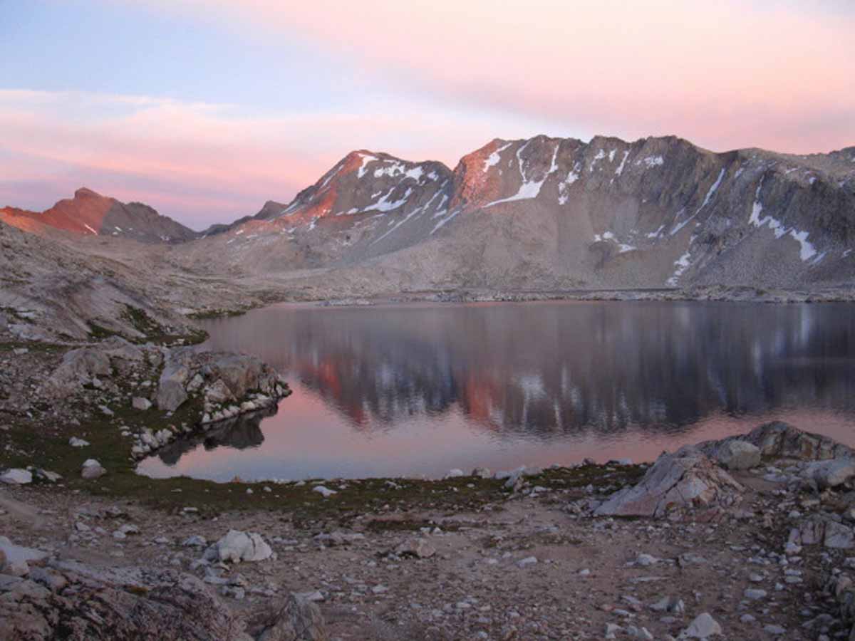
Conditions are currently ideal for Fall Backpacking in the High Sierra, if certain precautions are taken. First, we've got to understand that the temps can plunge. Proper insulation for a worse-case weather scenario is vital. Second, we understand that a freak storm can blow in, bringing Winter conditions to the High Sierra early, if the storm comes out of the cooling Northwest. A freak storm out of the tropical seas to our Southwest can scour the Crest with lightening and slushy downpours, while pounding the flanks with tropical downpours.


Current Surface Lows & 7-Day Freezing Temps

Having the proper gear to deal with these eventualities (hike long enough, and the freak storms & weather will find you) is vital.

My point is even when Nature is showing us the most benign conditions of a gentle Fall season at the start of our hike, these mosquito-free days of crisp conditions and striking contrasts can rapidly transform into dangerous conditions for the unprepared when the weather gets fired-up.
Despite the fact that NOAA is talking-up the odds of an El Nino, of a buildup of hot water in the Central-West Pacific sliding East into an El Nino configuration, I don't see it happening... well, I put the odds of an El Nino building this Winter at less than half of where NOAA is setting them.
Heck, I still see the cold water churn of the La Nina operating...
El Nino-La Nina Tools

Let's see what the Climate Prediction Center has to say about the upcoming Winter.

Comments? What do you think is going on?


2017


2016
NOTE on TYPICAL OCTOBER ISSUES

Oct
A La Nina streak of Central-East Pacific very cold water was building, now is pulsing through mid-October.
This is generally indicative of a very cold dry Winter in the Sierra and West Coast.

ENSO GRAPHIC

I describe the factors controlling the outcome of the great planetary forces at play: An El Nino beyond all historical conceptions transitioning into La Nina conditions. A Great North Pacific High that is acting as persistent this season as the last four, and finally, an Arctic Circle that is not the spinning disc of fierce cold that traditionally draws the jet stream up to it.

(Oct 24 Update: Rising low "tendencies" over the NE Pacific have coalesced into a big, but not very deep, low pressure zone that established itself over the NE Pacific off Seattle a few days ago. It has been large and fairly stationary for a few days now.)

RUN THE SURFACE MAP

Mid-Pacific Weather Factors are all out of kilter. How they come to a balance between their competing and cooperating forces will determining exactly how the power and influences of this burbbeling La Nina will influence our Winter weather.

A La Nina typically brings cold, dry Winters. Not so far. We've seen a more "normal" an October than I've seen for decades.

RUN THE SURFACE MAP

2014 Calendar          2015 Calendar          2016 Calendar          2017 Calendar

2016
SPECIFIC OBSERVATIONS

Oct 16
Wow. We are experiencing the outlines of a classic, "traditional" wet Fall. Is this just a "wet" aberration in the progress of increasingly drier, warmer Winter weather? Or are these storms heralding a return to a snow covered Sierra Winter, for at least this year? The answer to these questions hinges on a number of "big" questions.

Will the North Pacific High reform and deflect the wet jet stream around us again this Winter? Will the Arctic cool down and behave normally? Will the La Nina strengthen, weaken, or disappear? All of these major weather "factors" have been behaving strangely. I expect their strange and surprising behaviors to continue, which will continue to bring unusual configurations of weather as they interact with each other in brand-new ways to produce brand-new weather patterns with new characters and behaviors.

Stay tuned. The real greatest show on the planet is playing itself out on the L, L, & G stages of life right in front of us!
(That's "Liquids, Land Masses, & Gasses." )

Oct 24 Update
Rising and persisting low-pressure "tendencies" over the NE Pacific have coalesced into a big, but not very deep, low pressure zone that established itself in a stationary over the NE Pacific off Seattle a few days ago. It has been large and fairly stationary for a few days now.

This concentration of persisting low pressure has sucked these warm storm fronts up from the Southwest, out from the waters and skies around Hawaii, since October 14.

Oct 29 2016
High Temps bring cold rains on the verge of being snow flurries, while snow flurries melt upon hiker contact: THIS IS VERY DANGEROUS.
Excellent Gear Required.
We must be able to stay warm in freezing rains.

RUN THE SURFACE MAP


HIGH SIERRA
Winter Backpacker
WEATHER RESOURCES


ALL SNOW
INFORMATION


Snowfall
on the
Ground


Rain-Snow
Probabilities


Rain-Snow
Forecasts

The Tweener
October is the last month we can almost rely on great backpacking weather.

We can bank on serious early-season storms every few years. Don’t get stuck out without the gear necessary to survive, keep traveling, and enjoy it.

Is this one of those years?

2018

End of September through Late October:
Not too Cool-Not too Hot

IDEAL BACKPACKING WEATHER


2016
Wow. Two Oct storms by the 14th gives this Winter a more "typical," feel of a "traditional" wet Fall than we've been getting used-to over the past twenty years.

This is potentially a good omen for a fantastic Winter backpacking season in the Sierra.

This means those backpackers who've gotten accustomed to fine, clear weather in Fall better re-assess your Fall hiking plans for more traditional cold & wet conditions.

Winter Backpackers?
Get Ready to Rumble!

HAZARD ALERT
Oct 29 2016
High Temps bring cold rains on the verge of being snow flurries, while snow flurries melt upon hiker contact:
THIS IS VERY DANGEROUS.
Excellent Gear Required.
We must be able to stay warm in freezing rains.

2014 Calendar          2015 Calendar

2016 Calendar

October

October in the High Sierra is stunningly beautiful, but potentially very dangerous.

Every few years a strong unexpected Winter Storm comes in early and dumps a couple of unexpected feet of snow on the High Sierra.

Leaving detailed trip plans with an outside monitor is required. Packing Winter Gear elements, knowing how to survive and travel in the snow, and having contingency plans is REQUIRED.

2015 HISTORY

BACKPACKER ALERT

The threats are fire and tropical weather.

The enduring trend of shortening Winters and the subsequent significant diminishment of Rain and Snowpack during the last 25 years has evolved into a completely different weather pattern. The storms out of the Northwest, in fact the whole North Pacific Weather Pattern has been disrupted. I would say it has been shattered.

The various unhinged elements of our old pattern have not re-established a new pattern (they are still changing!), but two facts are crystal clear. First, our traditional pattern of Winter storms out of the Northwest has been shattered. It will likely re-occur every 3 to 7 years on a diminishing cycle. Winters dominated by storms out of the Northwest is done as the dominant feature driving Winter weather on the whole Northwest Coast of the US.

(I see two factors driving the Degradation of the North Pacific Winter Weather Pattern:

Factor
A> The significant warming of the Arctic Circle during Winter has diminished the polar region's ability to draw West Pacific storms up to the perimeter of its once powerful spinning vortex of brutal cold, to "power them up," and toss them across the West Coast of the US.

Factor B> The warmth of the North Pacific ocean surface and atmosphere during Winter in N Latitudes has deflected the path of the typical North Pacific Winter Jet Stream across the Northeast Pacific, leaving the West Coast of the US dry.
The combined effects of the warming Arctic Circle and North Pacific Jet Stream changes are also responsible for the great "slides" South of Cold Arctic air masses over the Mid-West and East Coast over the last few Winters, causing those "polar vortexes."

Typical Winter storm patterns are not being drawn up to the Arctic Circle, they are not being fired up by the spinning vortex of the North Polar Region during Winter, nor are the resulting super-charged storms riding the Jet Stream down to California. That's the pattern that's over, the old pattern that drove fertility in California and the High Sierra.)

Second, the temperatures and humidity have risen to levels un-natural for the North Latitudes. We appear to be moving towards a tropical "Wet and Dry"-season type of pattern at 38 N. We'll see. We've loosened the forces of chaos, now we will see what happens, and where they end up.

The establishment of new basic metrological conditions in the North Pacific and Arctic Ocean assures that this new weather pattern has just now begun to re-order the type and distribution of plant and animal life rapidly under its changed footprint, forcing all to adjust to the new reality. Here in California that will be through fire for the trees, and lack of water for the animals and humans.

New plants, animals, and trees more suited to the hotter, drier climate will replace those burned, until they too are supplanted.

For backpackers this means that the rising threats into this year's September are massive fires and unexpected tropical downpours.


Mountain Safety

?

July typicall brings the peak of the Summer Thunderstorm Season in the High Sierra.
These are typically local weather, caused by heat waves in the San Joaquin Valley swept up the West Sierra Flank.

Hot wet air on a fast ride up the West Sierra flank to high elevations squeezes out what can be substantial daily rain and lightening activity lasting between 2 pm and sunset.

Now, we are seeing serious tropical moisture out of the Southwest bringing potential electrical activity and death to the Sierra.

BEWARE

Don’t cross open ground under one of these storms. They are deadly. Lightening and Fording are the leading causes of High Sierra backpacker deaths.

More Lightening Information                  Lightening Prediction Tools

Typical Scene: Video

Story
Caught Out with Bubba & Dave


Tahoe to Whitney

Top of Page

2018
High Sierra
Backpacking Calendar

January         February         March         April         May         June

July         August         September         October         November         December


2014 Calendar          2015 Calendar

2016 Calendar          2017 Calendar

Trailhead
 
Contact
Alex Wierbinski

top of page

Lake Tahoe to Mount Whitney

Your guide to backpacking the Sierra Crest, including the Tahoe to Yosemite, Pacific Crest, and John Muir Trails

top of page

© 2018 Lake Tahoe to Mount Whitney: Crown Jewel of the Pacific Crest Trail