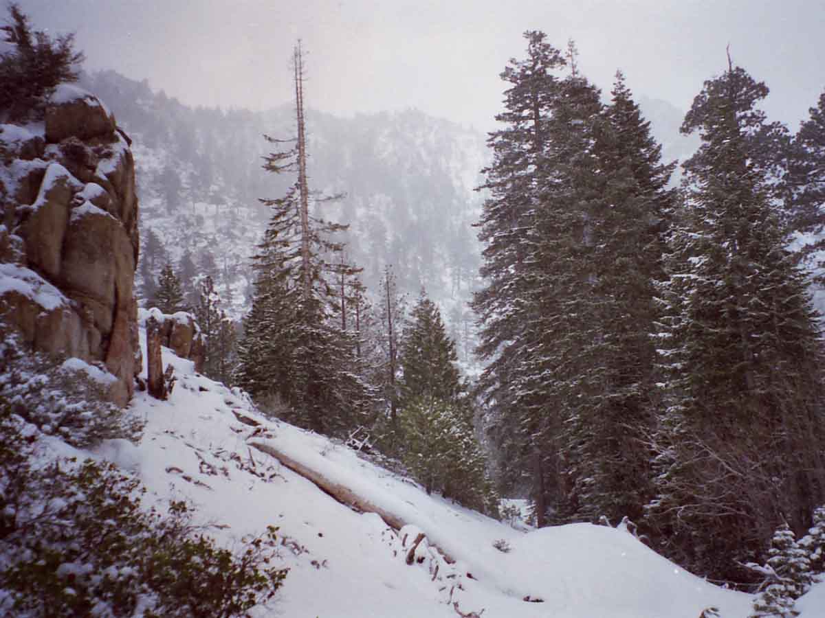
Looking back, Northwest by the compass, as we climb South up into the East Carson River up towards the PCT under a light Snow in April of 2000.
The PCT runs the ridge in the background. We'll get up there soon. At the position above we are climbing up to Carson Falls on our way following the East Carson River a bit short of nine miles
up to the PCT.
Entry was through Rodriquez Flat, above the town of Walker on Highway 395.
Trail Forum Map Miles and Elevations (PCT)
End of March
April 2018
January February March April May June July August September October November December
| Sunday |
Monday |
Tuesday |
Wednesday |
Thursday |
Friday |
Saturday |
"Open"
Spring Conditions
in
2018
?
Typically,
Access Depends on Conditions.
Conditions on the ground, NOT a date on the calendar determines our gear and skills requirements.
Spring has been clearing mountain trails earlier and earlier over the the last twenty-five years, and especially the last seven years.
2018
A Weak Snow Pack as of April 1
Spring of 2018
Danger
We've seen a long trend of earlier and earlier Spring Openings of Sierra Crest Trails, creating expectations of early openings. This year was following trend until our wet March, bringing a quarter of normal snowpack up to half.
Though this still bodes well for early starts on the PCT & JMT, the die is not yet cast.
Warm Torrential Tropical Rains could yet scour the snow from the Sierra Crest, while a cold version of Tropical Rains could still deposit many more feet along the Sierra Crest and Flanks.
Both would be "tail" events, with the most likely outcome being a quick Spring Thaw under warm conditions, and an earlier than "average" opening of Sierra Crest Trails.
2017
"Open"
Spring Conditions?
NOT 2017:
HUGE PACK ON THE CREST
The 2017 Spring Thaw was Under
WINTER SNOW CONDITIONS
2016
A slightly below average snowpack |
MARCH
27
High
Off West Coast of USA
Clear and Warm
Warm Days-Cold Nights
Summer Conditions
2018
Snowpack:
Percent of Average for
March 27
+/- change since
March 23
N Sierra: 48%
(+4%)
Cen. Sierra: 65%
(=%)
S Sierra: 56%
(-1%)
Ca State: 58%
(+2%)
Last
March 23
March 22
March 20
March 14, 2018
March 5, 2018
March 1, 2018
Feb 24, 2018
Statewide Summary of Snow Water Content PDF
2018
HIGH SIERRA
--WINTER--
Temp-Snow Check
After the 25th* Front-"storm" this Fall & Winter.
The last fronts before this incident came across on the 22nd of March.
Let's check our reporting station snow & temp readings.
Below: Watershed Snow Water Content Charts followed by individual reporting station's Snow Depth and
24 hour high-low temps.
Last Report:
March 23, 2018
A NEW WATER YEAR
N Sierra Reporting Stations On a Map
Scroll over stations for snow & temps. Click for
full report.
South Sierra Stations
"+/- & =" below are changes since last reading.
Tahoe Basin
Watershed
Rubicon 47" -6
7618 feet
(31.4 H2O) +.4
33 & 29 +/+
Echo Peak 75" -5
7652 feet
(43.8 ?H2O) -.2
37 & 17 +/+
American-Yuba Watersheds
Carson Pass 87" -7
8388 feet
(27.5" H2O) +.2
33 & 13 +/-
Carson-Walker
Watersheds
Ebbetts Pass 93 " -8
8660 feet
(40.1" H2O) =.0
33 & 15 +/-
Leavitt Lke 144" -8
(errors)
9602 feet, East Flank
(30.3" H20) -.61
26
& 8 +/-
Marine Base
6748 feet East Flank
FULL REPORT
VIS-CHIL-WEA-MB-WIND
38 & 9 +/-
Mokelumne-Stanislaus Watersheds
Deadman Creek
9250 feet, West Flank
000.0 Snow (BAD?)
(29.16" ?H20) +0.12(BAD?)
45
& 17 +/+
Tuolumne-Merced
Watersheds
Tenaya Lake 56.91" -4.62
8163 feet, West Flank
(17.05) ?H20 +0.51
50
& 27 +/+
Tuolumne Meadows
8600 feet, West Flank
36.72" -5.51
47 & 11 +/-
Tioga Pass/Dana
9798 feet
69.04" Snow -5.56
--.--" H20) (ERROR?)
(Temps NONE)
Mammoth Mountain Ski
Mono Lake-Owens Basin
Gem Pass
10750 feet
SNO " Depth Suspect
(23.15" H2O) -.15 Suspect Suspect
temps suspect
Mammoth Pass
9500 feet
119.65" Snow -3.13
(37.52" H2O) =0.00
50 & 13 +/-
South Lake Cabin
9580 feet, East Flank
(Snow BAD")
(18.1 H2O??) =.0
33 & 13 -/-
Big Pine Sawmill
10200 feet, East Flank
38.2" Snow -6.7
50 & 5 +/-
Kings River
Bishop Pass
11972 feet
BAD- BAD
Charlotte Lake
10398 feet, West Flank
TEMPS ONLY
-- & -- BAD
(The coldest station)
Kern Watershed
Upr Tyndall Creek
11441 feet
62.5" Snow +1.01
35 & 13 +/+
(station
reporting again!)
All High Sierra
Reporting Stations
*We've had more than twenty-five fronts come across the Sierra, and periods of spitting snow, but only twenty-five fronts of any substance.
Watersheds and Selected Network of Crestline Sensors
All Sierra Forecast Zones
All Precip Forecasts
LAST MONTH
NEXT WEEK
2017
Current Snowpack:
Percent of Average for
March 27.
N Sierra: 145%
Cen. Sierra: 174%
S Sierra: 166%
Ca State: 163%
Statewide Summary of Snow Water Content PDF
Last Reading:
March 1
|
MARCH
28
High
Off West Coast of USA
Clear and Warm
Warm Days-Warm Nights
Top
Selected
Weather
Resources
Surface Low Pressure Tracks
Radar
Visible Satellites
Water Vapor Satellites
MAPS
Sierra Forecasts
Western US Forecasts
Precip Animation & Charts
Graphical Precip Forecast
All Sierra Snow Info
Sierra Sensor Networks
Watersheds and Selected Network of Crestline Sensors
High Sierra Highways
All Weather Information
LAST MONTH
NEXT WEEK
Top
2017
Clear. Big High building off Coast of California. |
MARCH
29
High Weakens
Off West Coast of USA
Cloud Cover and Warm
Warm Days-Warm Nights
LAST MONTH
NEXT WEEK
Top
Top
2017
Clear. Vast High building off Coast of California, Temps building.
Current
Pac Surface Map
General Weather Status
Tropical Activity Moderate off NE coast of Indonesia.
Vast Low in N Cen Pac sucking up most Tropical Moisture from Indonesia...
VAST HIGH OFF CA COAST deflecting most of the rest of this moisture around us.
TEMPS WARMING,
But still cool.
Our expanding stationary High will warm things up and begin the Spring Thaw in earnest during the next couple of days.
|
MARCH
30
High Weakens
Off West Coast of USA
Cloud Cover and Warm
Warm Days-Warm Nights
A bit Cooler
TOP
LAST MONTH
NEXT WEEK
Top
LAST MONTH
NEXT WEEK
2017
Clear. Vast High building off Coast of California, Temps building. Windy.
SAFETY FIRST
Cayenne's First Aid Approach
2017
"I honestly think that very few people will complete the PCT this year because the Cascades have had an amazing amount of snow too. Crater Lake, Mt. Bachelor, Mt. Hood and Mt. Baker are all having record snow years too."
Top |
MARCH
31
Instability
Off West Coast of USA
Less Cloud Cover, Clear, and Warm
Warm Days-Warm Nights
A bit Cooler
A flurry of weak local Lows lay atop a great High Pressure Ridge off West Coast of USA.
No precip whatsoever
SUMMER
Backpackers
Time again to begin observing Winter transitioning into Spring
SPRING
Backpackers
Time to begin tracking the weather to find and get in this year's last snow trips before the Spring Thaw begins in Earnest.
2018
HIGH SIERRA
--WINTER--
Temp-Snow Check
After the 25th* Front-"storm" this Fall & Winter.
The last fronts before this incident came across on the 22nd of March.
Let's check our reporting station snow & temp readings.
Below: Watershed Snow Water Content Charts followed by individual reporting station's Snow Depth and
24 hour high-low temps.
Last Report:
March 27, 2018
A NEW WATER YEAR
N Sierra Reporting Stations On a Map
Scroll over stations for snow & temps. Click for
full report.
South Sierra Stations
"+/- & =" below are changes since last reading.
Tahoe Basin
Watershed
Rubicon 44" -3
7618 feet
(31.4 H2O) =.0
57 & 38 +/+
Echo Peak 65" -10
7652 feet
(43.8 ?H2O) =.0
57 & 37 +/+
American-Yuba Watersheds
Carson Pass 67" -20
8388 feet
(27.5" H2O) =.0
56 & 30 +/+
Carson-Walker
Watersheds
Ebbetts Pass 82 " -11
8660 feet
(40.2" H2O) +.1
57 & 34 +/+
Leavitt Lke 135" -9
(errors)
9602 feet, East Flank
(39.6" H20) +9.3
51
& 32 +/+
Marine Base
6748 feet East Flank
FULL REPORT
VIS-CHIL-WEA-MB-WIND
65 & 22 +/+
Mokelumne-Stanislaus Watersheds
Deadman Creek
9250 feet, West Flank
000.0 Snow (BAD?)
(29.28" ?H20) +0.12(BAD?)
51
& 21 +/+
Tuolumne-Merced
Watersheds
Tenaya Lake 51.91" -5.00
8163 feet, West Flank
(17.05) ?H20 =0.00
56
& 26 +/-
Tuolumne Meadows
8600 feet, West Flank
31.09" -5.63
53 & 20 +/+
Tioga Pass/Dana
9798 feet
59.03" Snow -10.01
--.--" H20) (ERROR?)
(Temps NONE)
Mammoth Mountain Ski
Mono Lake-Owens Basin
Gem Pass
10750 feet
SNO " Depth Suspect
(22.68" H2O) -.47 Suspect Suspect
temps suspect
Mammoth Pass
9500 feet
106.38" Snow -13.27
(37.64" H2O) +.12
58 & 30 +/+
South Lake Cabin
9580 feet, East Flank
(Snow BAD")
(18.1 H2O??) =.0
59 & 26 +/+
Big Pine Sawmill
10200 feet, East Flank
26.21" Snow -11.99
51 & 26 +/+
Kings River
Bishop Pass
11972 feet
BAD- BAD
Charlotte Lake
10398 feet, West Flank
TEMPS ONLY
-- & -- BAD
(The coldest station)
Kern Watershed
Upr Tyndall Creek
11441 feet
54.53" Snow -7.97
48 & 30 +/+
(station
reporting again!)
All High Sierra
Reporting Stations
*We've had more than twenty-five fronts come across the Sierra, and periods of spitting snow, but only twenty-five fronts of any substance.
Watersheds and Selected Network of Crestline Sensors
All Sierra Forecast Zones
All Precip Forecasts
LAST MONTH
NEXT WEEK
2017
Clear. Vast High building off Coast of California, Temps building. Windy.
PREVIOUS:
BACKPACKER ALERT
March 22, 2017
|
| Sunday |
Monday |
Tuesday |
Wednesday |
Thursday |
Friday |
Saturday |
1
High Weakens
Off West Coast of USA
Cloud Cover, Clear, and Warm
Warm Days-Warm Nights
2017
Snow & Temps
2017
BACKPACKER ALERT
April 1, 2017
Standing
Terrain Hazard Alert
Current Snowpack:
Percent of Average for
April 1.
N Sierra: 147%
Cen. Sierra: 175%
S Sierra: 166%
Ca State: 164%
Statewide Summary of Snow Water Content PDF
Cal Coop Snow Survey
Last Readings:
March 27
March 1
2017
Clear. Big High building off Coast of California. Staying cold on the Crest.
Weather Page
Daily Snow Sensor Report
2017
Below: Watershed Snow Water Content Charts followed by individual reporting station's Snow Depth and
24 hour high-low temps: |
2
High Weakens
Off West Coast of USA
Clear and Warm
Warm Days-Warm Nights
2017
Clear. Big High building off Coast of California. Staying cold on the Crest.
High-Low pattern in North Pacific opening up a potential tropical transport window in four-five days? |
3
High Weakens
Off West Coast of USA
Clear and Warm
Warm Days-Warm Nights
2018
Snowpack
Percent of Average for
April 3
+/- change since
March 27
N Sierra: 41%
(-7%)
Cen. Sierra: 59%
(-6%)
S Sierra: 49%
(-7%)
Ca State: 51%
(-7%)
Last
March 27
March 23
March 22
March 20
March 14, 2018
March 5, 2018
March 1, 2018
Feb 24, 2018
Statewide Summary of Snow Water Content PDF
2018
HIGH SIERRA
--WINTER--
Temp-Snow Check
After the 25th* Front-"storm" this Fall & Winter.
The last fronts before this incident came across on the 22nd of March.
Let's check our reporting station snow & temp readings.
Below: Watershed Snow Water Content Charts followed by individual reporting station's Snow Depth and
24 hour high-low temps.
Last Report:
March 31, 2018
A NEW WATER YEAR
N Sierra Reporting Stations On a Map
Scroll over stations for snow & temps. Click for
full report.
South Sierra Stations
"+/- & =" below are changes since last reading.
Tahoe Basin
Watershed
Rubicon 39" -5
7618 feet
(31.4 H2O) =.0
49 & 35 -/-
Echo Peak 57 " -8
7652 feet
(43.7 ?H2O) -.1
50 & 34 -/-
American-Yuba Watersheds
Carson Pass 64" -3
8388 feet
(27.54" H2O) -.1
48 & 29 -/-
Carson-Walker
Watersheds
Ebbetts Pass 75 " -7
8660 feet
(40.2" H2O) =.0
49 & 29 -/-
Leavitt Lke 129" -6
(errors)
9602 feet, East Flank
(39.6" H20) =0.0
42
& 28 -/-
Marine Base
6748 feet East Flank
FULL REPORT
VIS-CHIL-WEA-MB-WIND
59 & 29 -/+
Mokelumne-Stanislaus Watersheds
Deadman Creek
9250 feet, West Flank
000.0 Snow (BAD?)
(28.92" ?H20) -0.36(BAD?)
45
& 15 -/-
Tuolumne-Merced
Watersheds
Tenaya Lake 47.03" -4.88
8163 feet, West Flank
(17.05) ?H20 =0.00
51
& 23 -/-
Tuolumne Meadows
8600 feet, West Flank
31.09" -4.02
53 & 19 =/-
Tioga Pass/Dana
9798 feet
53.56" Snow -5.47
--.--" H20) (ERROR?)
(Temps NONE)
Mammoth Mountain Ski
Mono Lake-Owens Basin
Gem Pass
10750 feet
SNO " Depth Suspect
(22.34" H2O) -.34 Suspect Suspect
temps suspect
Mammoth Pass
9500 feet
100.18" Snow -6.2
(37.72" H2O) +.08
51 & 26 -/-
South Lake Cabin
9580 feet, East Flank
(Snow BAD")
(18.1 H2O??) =.0
56 & 20 -/-
Big Pine Sawmill
10200 feet, East Flank
26.21" Snow -2.91
47 & 17 -/-
Kings River
Bishop Pass
11972 feet
BAD- BAD
Charlotte Lake
10398 feet, West Flank
TEMPS ONLY
-- & -- BAD
(The coldest station)
Kern Watershed
Upr Tyndall Creek
11441 feet
52.18" Snow -2.35
48 & 22 -/-
(station
reporting again!)
All High Sierra
Reporting Stations
*We've had more than twenty-five fronts come across the Sierra, and periods of spitting snow, but only twenty-five fronts of any substance.
Watersheds and Selected Network of Crestline Sensors
All Sierra Forecast Zones
All Precip Forecasts
2017
Snow & Temps
2017
Clear. Big Highs moving East off of Coast of California.
Big Low forming in Gulf Alaska.
CREST WARMING UP,
Alley between Low & High for Tropical Moisture Transport opening up.
Substantial blast of precip heading our way in 4-5 days. Question is, how warm will it be?
Warm rains across the crest bring disaster.
2017
Below: Watershed Snow Water Content Charts followed by individual reporting station's Snow Depth and
24 hour high-low temps:
|
4
2017
Hazy from cold trop Front off shore stretching from North of Hawall to the Low it's anchored to in Gulf Alaska.
There are a set of Lows behind this Front, each carrying potentially more moisture.
Why? Right now increasing T Storm activity is hugging N Coast of Indonisa, and its surrounding waters are warming.
Temps in the Cen Pac are currently rising. More moisture is pouring into the atmosphere down there.
That potentially charges up the transport mechanisms.
All the cards are still on the table for a wide range of epic Spring Thaw outcomes. The game certainly is on, and we will see how it all plays out. |
5
Low
Off NW Coast of USA
Tropical Transport Mechanism Front Lines Approach
STORM WARNINGS
High Temps
Rain Across the Sierra Crest
LAST WEEK
NEXT WEEK
2018
HIGH SIERRA
--WINTER--
Temp-Snow Check
Before the 26th* Front-"storm" this Fall & Winter.
The last fronts before this incident came across on the 22nd of March.
Let's check our reporting station snow & temp readings.
Below: Watershed Snow Water Content Charts followed by individual reporting station's Snow Depth and
24 hour high-low temps.
Last Report:
April 3, 2018
A NEW WATER YEAR
N Sierra Reporting Stations On a Map
Scroll over stations for snow & temps. Click for
full report.
South Sierra Stations
"+/- & =" below are changes since last reading.
Tahoe Basin
Watershed
Rubicon 36" -3
7618 feet
(31.5 H2O) +.1
53 & 37 +/+
Echo Peak 53 " -4
7652 feet
(43.5 ?H2O) -.2
53 & 40 +/+
American-Yuba Watersheds
Carson Pass 58" -6
8388 feet
(27.50" H2O) -.04
53 & 32 +/+
Carson-Walker
Watersheds
Ebbetts Pass 72 " -3
8660 feet
(40.1" H2O) -.1
53 & 36 +/+
Leavitt Lke 126" -3
(errors)
9602 feet, East Flank
(39.6" H20) =0.0
47
& 33 +/+
Marine Base
6748 feet East Flank
FULL REPORT
VIS-CHIL-WEA-MB-WIND
63 & 31 +/+
Mokelumne-Stanislaus Watersheds
Deadman Creek
9250 feet, West Flank
000.0 Snow (BAD?)
(29.04" ?H20) +0.12(BAD?)
55
& 31 +/+
Tuolumne-Merced
Watersheds
Tenaya Lake 47.03" -2.31
8163 feet, West Flank
(17.05) ?H20 =0.00
54
& 32 +/+
Tuolumne Meadows
8600 feet, West Flank
31.09" -5.34
52 & 31 -/+
Tioga Pass/Dana
9798 feet
50.47" Snow -3.09
--.--" H20) (ERROR?)
(Temps NONE)
Mammoth Mountain Ski
Mono Lake-Owens Basin
Gem Pass
10750 feet
SNO " Depth Suspect
(22.01" H2O) -.33 Suspect Suspect
temps suspect
Mammoth Pass
9500 feet
100.18" Snow -4.32
(37.8" H2O) +.08
56 & 29 +/+
South Lake Cabin
9580 feet, East Flank
(Snow BAD")
(18.1 H2O??) =.0
55 & 35 +/+
Big Pine Sawmill
10200 feet, East Flank
26.21" Snow -4.71
49 & 31 +/+
Kings River
Bishop Pass
11972 feet
BAD- BAD
Charlotte Lake
10398 feet, West Flank
TEMPS ONLY
-- & -- BAD
(The coldest station)
Kern Watershed
Upr Tyndall Creek
11441 feet
49.96" Snow -2.22
44 & 31 -/+
(station
reporting again!)
All High Sierra
Reporting Stations
*We've had more than twenty-five fronts come across the Sierra, and periods of spitting snow, but only twenty-five fronts of any substance.
Watersheds and Selected Network of Crestline Sensors
All Sierra Forecast Zones
All Precip Forecasts
2017
Snow & Temps
2017
Hazy from cold trop Front off shore stretching from North of Hawall to the Low it's anchored to in Gulf Alaska.
There are a set of Lows behind this Front, each carrying potentially more moisture.
STEADY CREST WARMING
|
6
Low
Off NW Coast of USA
Tropical Transport Mechanism Front Lines Approach
WARM & WET
TOP
Selected
Weather
Resources
Surface Low Pressure Tracks
Radar
Visible Satellites
Water Vapor Satellites
MAPS
Sierra Forecasts
Western US Forecasts
Precip Animation & Charts
Graphical Precip Forecast
All Sierra Snow Info
Sierra Sensor Networks
Watersheds and Selected Network of Crestline Sensors
High Sierra Highways
All Weather Information
2017
Snow & Temps
2017
STORM WARNING
Temps above freezing overnight along N Sierra Crest. AM precip, scattered showers through day strengthening into evening.
This storm is adding to the difficulty of those few PCT hikers who have the skill and gear necessary to access the existing massive snow pack at this early date.
Those who were attempting to cross the snow covered Sierra without the proper gear are currently being schooled, and are trying to figure how they can get down and out as quickly as possible.
Daytime Temps above freezing to 10,000 feet or so... which means lots of cold, freezing rain with sleet into snow, depending on how high or low we go. Nasty.
For Something Completely Different,
(Than 2017!):
See 2015 Report
2015: KM to Open last weekend
of this month.
2016
Heat Wave Records
24 hr High-Low & Snow Dp.
2016 Station REPORTS
Carson Pass
54 & 31 degrees, 69"
Ebbetts Pass
53 & 31 degrees, 67"
Sonora Pass
54
& 28 degrees, 55"
Tuolumne Meadows
63 & 25 degrees, 25" |
7
Low
Off NW Coast of USA
Tropical Transport Mechanism Front Lines crosses Sierra
End of Rain
High Building In
SPRING THAW
RIVER INFORMATION
RESERVOIRS
note extreme rainfall over last 24 hours in bold
2018
HIGH SIERRA
--WINTER--
Temp-Snow Check
After the 26th* Front-"storm" this Fall & Winter.
The last fronts before this incident came across on the 22nd of March.
Let's check our reporting station snow & temp readings.
Below: Watershed Snow Water Content Charts followed by individual reporting station's Snow Depth and
24 hour high-low temps.
Last Report:
April 5, 2018
A NEW WATER YEAR
N Sierra Reporting Stations On a Map
Scroll over stations for snow & temps. Click for
full report.
South Sierra Stations
"+/- & =" below are changes since last reading.
Tahoe Basin
Watershed
Rubicon 32" -4
7618 feet
(31.5 H2O) +2.6
46 & 37 -/=
Echo Peak 48 " -5
7652 feet
(43.5 ?H2O) +5.5
45 & 36 -/-
American-Yuba Watersheds
Carson Pass 53" -5
8388 feet
(29.70" H2O) +2.2
45 & 36 -/-
Carson-Walker
Watersheds
Ebbetts Pass 66" -6
8660 feet
(42.6" H2O) +2.5
43 & 34 -/-
Leavitt Lke 120" -6
(errors)
9602 feet, East Flank
(42.1" H20) +2.5
44
& 34 -/+
Marine Base
6748 feet East Flank
FULL REPORT
VIS-CHIL-WEA-MB-WIND
56 & 31 -/+
Mokelumne-Stanislaus Watersheds
Deadman Creek
9250 feet, West Flank
000.0 Snow (BAD?)
(30.84" ?H20) +1.8(BAD?)
42
& 35 -/+
Tuolumne-Merced
Watersheds
Tenaya Lake 39.38" -7.65
8163 feet, West Flank
(20.92) ?H20 +3.87
45
& 37 -/+
Tuolumne Meadows
8600 feet, West Flank
22.73" -8.36
42 & 35 -/+
Tioga Pass/Dana
9798 feet
47.71" Snow -2.76
--.--" H20) (ERROR?)
(Temps NONE)
Mammoth Mountain Ski
Mono -Owens Basin
Gem Pass
10750 feet
SNO " Depth Suspect
(20.81" H2O) -1.2 Suspect Suspect
temps suspect
Mammoth Pass
9500 feet
91.9" Snow -8.28
(41.4" H2O) +3.6
56 & 29 +/+
South Lake Cabin
9580 feet, East Flank
(Snow BAD")
(18.4 H2O??) +.3
49 & 39 -/+
Big Pine Sawmill
10200 feet, East Flank
16.6" Snow -9.61
45 & 36 -/+
Kings River
Bishop Pass
11972 feet
BAD- BAD
Charlotte Lake
10398 feet, West Flank
TEMPS ONLY
-- & -- BAD
(The coldest station)
Kern Watershed
Upr Tyndall Creek
11441 feet
44.4" Snow -5.56
42 & 35 -/+
(station
reporting again!)
All High Sierra
Reporting Stations
*We've had more than twenty-six fronts come across the Sierra, and periods of spitting snow, but only twenty-six fronts of any substance.
Watersheds and Selected Network of Crestline Sensors
All Sierra Forecast Zones
All Precip Forecasts
2017
Snow & Temps
2017
STORM WARNING
Temps above freezing until 6 pm last evening brought rain then HEAVY SNOW:
AVALANCHE DANGER
Steady showers, cooling.
|
| Sunday |
Monday |
Tuesday |
Wednesday |
Thursday |
Friday |
Saturday |
8
High
Off West Coast USA
Low
Gulf Alaska
Dry
2017
Snow & Temps
2017
STORM WARNING
AM STORM diminishing into messy remnants clearing into what looks like will be a brief visit from a clear, cool High.
COLD WARNING TONIGHT
There is a weak, but potentially very wet Low & front behind it. Messy times ahead. |
9
High
Compressing Off West Coast USA
Low
Gulf Alaska
Dry
2017
COLD WARNING
Clear & Cold as long as the High off the Coast of Ca. holds up. A Day? Through tomorrow?
Weak Front attached to Low exiting Gulf Alaska will drag across N Sierra late on the 10th.
Weak, but steady Sierra storm activity 11th through 14th. Messy.
WARNINGS
ANOTHER COLD NIGHT
MASSIVE SNOWPACK
ANOTHER STORM COMING |
10
Low
Gulf Alaska
Weak Tropical Transport Mechanism Front Lines crosses Sierra
High
Compressing Off West Coast USA
Light Precip
Between the Two
2018
Snowpack
Percent of Average for
April 10
+/- change since
April 3
N Sierra: 36%
(-5%)
Cen. Sierra: 51%
(-8%)
S Sierra: 39%
(-10%)
Ca State: 43%
(-8%)
Last
March 27
March 23
March 22
March 20
March 14, 2018
March 5, 2018
March 1, 2018
Feb 24, 2018
Statewide Summary of Snow Water Content PDF
2018
HIGH SIERRA
--WINTER--
Temp-Snow Check
During the 27th* Front-"storm" this Fall & Winter.
The last fronts before this incident came across on the 5th of April.
Let's check our reporting station snow & temp readings.
Below: Watershed Snow Water Content Charts followed by individual reporting station's Snow Depth and
24 hour high-low temps.
Last Report:
April 7, 2018
A NEW WATER YEAR
N Sierra Reporting Stations On a Map
Scroll over stations for snow & temps. Click for
full report.
South Sierra Stations
"+/- & =" below are changes since last reading.
Tahoe Basin
Watershed
Rubicon 29" -3
7618 feet
(34.3 H2O) +2.8
57 & 35 +/-
Echo Peak 43 " -5
7652 feet
(43.5 ?H2O) +5.0
62 & 35 +/-
American-Yuba Watersheds
Carson Pass 50" -3
8388 feet
(29.70" H2O) =0.0
61 & 31 +/-
Carson-Walker
Watersheds
Ebbetts Pass 62" -4
8660 feet
(42.6" H2O) =0.0
60 & 30 +/-
Leavitt Lke 116" -4
(errors)
9602 feet, East Flank
(42.1" H20) =0.0
57
& 35 +/+
Marine Base
6748 feet East Flank
FULL REPORT
VIS-CHIL-WEA-MB-WIND
72 & 24 +/-
Mokelumne-Stanislaus Watersheds
Deadman Creek
9250 feet, West Flank
000.0 Snow (BAD?)
(30.96" ?H20) +.12(BAD?)
56
& 32 +/-
Tuolumne-Merced
Watersheds
Tenaya Lake 39.38" -2.89
8163 feet, West Flank
(20.92) ?H20 =0.00
62
& 30 +/-
Tuolumne Meadows
8600 feet, West Flank
22.73" -3.03
61 & 27 +/-
Tioga Pass/Dana
9798 feet
47.71" Snow -.36
--.--" H20) (ERROR?)
(Temps NONE)
Mammoth Mountain Ski
Mono -Owens Basin
Gem Pass
10750 feet
SNO " Depth Suspect
(20.81" H2O) -.19 Suspect Suspect
temps suspect
Mammoth Pass
9500 feet
86.39" Snow -5.51
(41.28" H2O) =.00
64 & 35 +/+
South Lake Cabin
9580 feet, East Flank
(Snow BAD")
(18.4 H2O??) =.0
64 & 37 +/-
Big Pine Sawmill
10200 feet, East Flank
13.4" Snow -3.2
54 & 34 +/-
Kings River
Bishop Pass
11972 feet
BAD- BAD
Charlotte Lake
10398 feet, West Flank
TEMPS ONLY
-- & -- BAD
(The coldest station)
Kern Watershed
Upr Tyndall Creek
11441 feet
41.6" Snow -2.8
52 & 33 +/-
(station
reporting again!)
All High Sierra
Reporting Stations
*We've had more than twenty-seven fronts come across the Sierra, and periods of spitting snow, but only twenty-seven fronts of any substance.
Watersheds and Selected Network of Crestline Sensors
All Sierra Forecast Zones
All Precip Forecasts
2017
Snow & Temps
2017
Clear & warming with approach of front.
April 1 Backpacker Alert:
Travel Hazard in Effect.
WATCHES
Cold Hazard
Storm Weather Hazard
|
11
Low
Gulf Alaska
Weak Tropical Transport Mechanism Front Lines crosses Sierra
High
Compressing Off West Coast USA
Moderate Precip Between the Two
Temps Plunge Overnight
Rain to and over the
Sierra Crest
LAST WEEK
NEXT WEEK
2017
Overcast & warm with landfall of weak front.
Light Precip N Ca.
SOME TEEN TEMPS
LAST NIGHT
Sloppy. Weak, gusty, & messy.
Afternoon: high 30s at 10000 feet up & down Crest. |
12
High
Building Off West Coast of USA
Clearing
MAPS
2018
Snowpack
Percent of Average for
April 12
+/- change since
April 10
N Sierra: 35%
(-1%)
Cen. Sierra: 47%
(-4%)
S Sierra: 36%
(-3%)
Ca State: 41%
(-2%)
Last
March 27
March 23
March 22
March 20
March 14, 2018
March 5, 2018
March 1, 2018
Feb 24, 2018
Statewide Summary of Snow Water Content PDF
2018
HIGH SIERRA
--WINTER--
Temp-Snow Check
After the 27th* Front-"storm" this Fall & Winter.
The last fronts before this incident came across on the 5th of April.
Let's check our reporting station snow & temp readings.
Below: Watershed Snow Water Content Charts followed by individual reporting station's Snow Depth and
24 hour high-low temps.
Last Report:
April 10,, 2018
A NEW WATER YEAR
N Sierra Reporting Stations On a Map
Scroll over stations for snow & temps. Click for
full report.
South Sierra Stations
"+/- & =" below are changes since last reading.
Tahoe Basin
Watershed
Rubicon 29" +0
7618 feet
(34.3 H2O) =0.0
45 & 22 -/-
Echo Peak 43 " -5
7652 feet
(49.5 ?H2O) +6.0
44 & 23 -/-
American-Yuba Watersheds
Carson Pass 51" +1
8388 feet
(29.80" H2O) +0.1
43 & 20 -/-
Carson-Walker
Watersheds
Ebbetts Pass 61" -1
8660 feet
(42.9" H2O) +0.3
42 & 19 -/-
Leavitt Lke 121" +5
(errors)
9602 feet, East Flank
(42.5" H20) +0.4
40
& 17 -/-
Marine Base
6748 feet East Flank
FULL REPORT
VIS-CHIL-WEA-MB-WIND
56 & 25 -/+
Mokelumne-Stanislaus Watersheds
Deadman Creek
9250 feet, West Flank
000.0 Snow (BAD?)
(30.84" ?H20) -.12(BAD?)
46
& 11 -/-
Tuolumne-Merced
Watersheds
Tenaya Lake 33.12" -6.26
8163 feet, West Flank
(21.02) ?H20 +0.10
47
& 8 -/-
Tuolumne Meadows
8600 feet, West Flank
19.66" -3.07
46 & 6 -/-
Tioga Pass/Dana
9798 feet
44.52" Snow -3.19
--.--" H20) (ERROR?)
(Temps NONE)
Mammoth Mountain Ski
Mono -Owens Basin
Gem Pass
10750 feet
SNO " Depth Suspect
(20.64" H2O) -.17 Suspect Suspect
temps suspect
Mammoth Pass
9500 feet
85.23" Snow -1.16
(41.44" H2O) +.24
46 & 10 -/-
South Lake Cabin
9580 feet, East Flank
(Snow BAD")
(18.4 H2O??) =.0
52 & 16 -/-
Big Pine Sawmill
10200 feet, East Flank
13.1" Snow -.3
48 & 14 -/-
Kings River
Bishop Pass
11972 feet
BAD- BAD
Charlotte Lake
10398 feet, West Flank
TEMPS ONLY
-- & -- BAD
(The coldest station)
Kern Watershed
Upr Tyndall Creek
11441 feet
41.09" Snow -.51
49 & 11 -/-
(station
reporting again!)
All High Sierra
Reporting Stations
*We've had more than twenty-seven fronts come across the Sierra, and periods of spitting snow, but only twenty-seven fronts of any substance.
Watersheds and Selected Network of Crestline Sensors
All Sierra Forecast Zones
All Precip Forecasts
2017
STORM WARNING
Weak warm front across Sierra, looks like afternoon rain and snow across crest.
Nasty, Wet, Cold Conditions...
It is a more dangerous cold when it's warmer and wetter than frozen-solid cold.
Backpacking
Plans?
Are our hiking plans and conditions on the ground in agreement?
2015
Earliest trail Opening in High Sierra History developing this year.
2016
Slight Below Average Snow,
EXCESSIVE HEAT.
Tahoe to Whitney Plan
2017
Record snowfall getting ready to unleash a record-level thaw.
|
13
Big High
Building Off West Coast of USA
Clear
Warm Days
Cold Nights
TOP
LAST WEEK
NEXT WEEK
SPRING THAW
RIVER INFORMATION
RESERVOIRS
TOP
2017
Snow & Temps
2017
STORM WARNING
CLEARING
Weak warm front clearing, almost across Sierra. |
14
View of Sierra on April 13 by the...
MODIS
SIERRA SATELLITE
All Sat Views
Selected
Weather
Resources
Surface Low Pressure Tracks
Radar
Visible Satellites
Water Vapor Satellites
MAPS
Sierra Forecasts
Western US Forecasts
Precip Animation & Charts
Graphical Precip Forecast
All Sierra Snow Info
Sierra Sensor Networks
Watersheds and Selected Network of Crestline Sensors
High Sierra Highways
All Weather Information
LAST WEEK
NEXT WEEK
2017
COLD WARNING
Clearing with brief High building in & out between Spring Storms...
Cooling.
WATCHES
Cold Hazard Rising
Truncated Report Today:
Al fell down and could not get up!
APPROACHING:
STORM CONDITION
NIGHTS OF THE 16th-20th
WEATHER HAZARD
Last Storm Weather Hazard Ending COLD, next storm approaches.
NEW ORDER
Temp & Snow Tables by Watershed and Highway Corridor |
| Sunday |
Monday |
Tuesday |
Wednesday |
Thursday |
Friday |
Saturday |
15
Low
Border of Ca-Or & Coast
Weak Tropical Transport Mechanism Front Line stretches South down the Coast, then bends SW towards Hawaii
SHOWERS
Big High
Building Off West Coast of USA
Last Week's Snow Reports
SKI RESORTS SHUTTING DOWN
2017
Snow & Temps
2017
COLD WARNING
Clearing with brief High building in & out between Spring Storms...
WATCHES
Cold Hazard Decreasing with approach of storm
|
16
Weak Low
On Coastline N of SF
Tropical Instability
Showers
COLD & TROPICAL
AIR MIXING
Big Highs
Building Off West Coast
of USA
Gulf Alaska Low
Headed Our Way
2018
Snowpack
Percent of Average for
April 16
+/- change since
April 12
N Sierra: 37%
(+2%)
Cen. Sierra: 47%
(=%)
S Sierra: 35%
(-1%)
Ca State: 41%
(=%)
Last
April 12
March 27
March 23
March 22
March 20
March 14, 2018
March 5, 2018
March 1, 2018
Feb 24, 2018
Statewide Summary of Snow Water Content PDF
2018
HIGH SIERRA
--WINTER--
Temp-Snow Check
After the 28th* Front-"storm" this Fall & Winter.
The last fronts before this incident came across on the 12th of April.
Let's check our reporting station snow & temp readings.
Below: Watershed Snow Water Content Charts followed by individual reporting station's Snow Depth and
24 hour high-low temps.
Last Report:
April 12, 2018
A NEW WATER YEAR
N Sierra Reporting Stations On a Map
Scroll over stations for snow & temps. Click for
full report.
South Sierra Stations
"+/- & =" below are changes since last reading.
Tahoe Basin
Watershed
Rubicon 37" +7
7618 feet
(34.3 H2O) +0.9
46 & 22 =/=
Echo Peak 50 " +7
7652 feet
(50.6 ?H2O) +1.1
44 & 22 =/-
American-Yuba Watersheds
Carson Pass 56" +5
8388 feet
(29.80" H2O) +0.7
45 & 21 +/+
Carson-Walker
Watersheds
Ebbetts Pass 61" +14
8660 feet
(44.2" H2O) +1.3
43 & 21 +/+
Leavitt Lke 136" +15
(errors)
9602 feet, East Flank
(44.2" H20) +1.7
39
& 24 -/+
Marine Base
6748 feet East Flank
FULL REPORT
VIS-CHIL-WEA-MB-WIND
57 & 34 +/+
Mokelumne-Stanislaus Watersheds
Deadman Creek
9250 feet, West Flank
000.0 Snow (BAD?)
(30.84" ?H20) +1.2(BAD?)
30
& 13 +/+
Tuolumne-Merced
Watersheds
Tenaya Lake 38.48" +5.36
8163 feet, West Flank
(21.18) ?H20 +0.16
35
& 19 -/+
Tuolumne Meadows
8600 feet, West Flank
19.66" +4.71
33 & 15 -/+
Tioga Pass/Dana
9798 feet
44.3" Snow -.22
--.--" H20) (ERROR?)
(Temps NONE)
Mammoth Mountain Ski
Mono -Owens Basin
Gem Pass
10750 feet
SNO " Depth Suspect
(21.1" H2O) +.46 Suspect Suspect
temps suspect
Mammoth Pass
9500 feet
??.??" Snow --.--
(41.44" H2O) +1.4
32 & 13 -/+
South Lake Cabin
9580 feet, East Flank
(Snow BAD")
(18.5 H2O??) +.1
33 & 14 -/-
Big Pine Sawmill
10200 feet, East Flank
13.2" Snow +.1
29 & 11 -/-
Kings River
Bishop Pass
11972 feet
BAD- BAD
Charlotte Lake
10398 feet, West Flank
TEMPS ONLY
-- & -- BAD
(The coldest station)
Kern Watershed
Upr Tyndall Creek
11441 feet
41.09" Snow -.51
27 & 6 -/-
(station
reporting again!)
All High Sierra
Reporting Stations
*We've had more than twenty-eight fronts come across the Sierra, and periods of spitting snow, but only twenty-eight fronts of any substance.
Watersheds and Selected Network of Crestline Sensors
All Sierra Forecast Zones
All Precip Forecasts
2017
STORM WARNING
Wet, Weak, & Warm Spring Storms are here...
WATCHES
Cold ended, NEW Storm Warning, Thaw, & Flooding too...
Truncated Report Today:
Al fell down and could not get up!
|
17
Big Highs
Building Onto West Coast
of USA
Clear & Crisp
Warming
Weak
Gulf Alaska Low
Headed Our Way
2017
Snow & Temps
2017
STORM WARNING
Wet, Weak, & Warm Spring Storms are here...
2016
Hot Day
ROADS OPENED AROUND THIS DATE
2015
ROAD REPORTS
ROAD CLOSURE HISTORY
|
18
Weak Low
Approaching Coastline N of SF
2018
Snowpack
Percent of Average for
April 18
+/- change since
April 16
N Sierra: 37%
(-%)
Cen. Sierra: 51%
(+4%)
S Sierra: 37%
(-2%)
Ca State: 44%
(+3%)
Last
April 16
April 12
March 27
March 23
March 22
March 20
March 14, 2018
March 5, 2018
March 1, 2018
Feb 24, 2018
Statewide Summary of Snow Water Content PDF
2018
HIGH SIERRA
--WINTER--
Temp-Snow Check
After the 29th* Front-"storm" this Fall & Winter.
The last fronts before this incident came across on the 12th of April.
Let's check our reporting station snow & temp readings.
Below: Watershed Snow Water Content Charts followed by individual reporting station's Snow Depth and
24 hour high-low temps.
Last Report:
April 16, 2018
A NEW WATER YEAR
N Sierra Reporting Stations On a Map
Scroll over stations for snow & temps. Click for
full report.
South Sierra Stations
"+/- & =" below are changes since last reading.
Tahoe Basin
Watershed
Rubicon 30" -7
7618 feet
(35.3 H2O) +1.0
37 & 18 -/-
Echo Peak 43 " -7
7652 feet
(50.6 ?H2O) =0.0
39 & 16 -/-
American-Yuba Watersheds
Carson Pass 50" -6
8388 feet
(30.5" H2O) +0.7
40 & 9 -/-
Carson-Walker
Watersheds
Ebbetts Pass 66" +5
8660 feet
(44.7" H2O) +.5
39 & 12 -/-
Leavitt Lke 127" -9
(errors)
9602 feet, East Flank
(44.5" H20) +0.3
37
& 8 -/-
Marine Base
6748 feet East Flank
FULL REPORT
VIS-CHIL-WEA-MB-WIND
34 & 22 -/-
Mokelumne-Stanislaus Watersheds
Deadman Creek
9250 feet, West Flank
000.0 Snow (BAD?)
(32.16" ?H20) +1.32(BAD?)
41
& 16 +/+
Tuolumne-Merced
Watersheds
Tenaya Lake 33.56" -4.92
8163 feet, West Flank
(21.70) ?H20 +0.52
39
& 19 +/=
Tuolumne Meadows
8600 feet, West Flank
17.13" -2.53
40 & 17 +/+
Tioga Pass/Dana
9798 feet
40.26" Snow -4.04
--.--" H20) (ERROR?)
(Temps NONE)
Mammoth Mountain Ski
Mono -Owens Basin
Gem Pass
10750 feet
SNO " Depth Suspect
(21.12" H2O) +.02 Suspect Suspect
temps suspect
Mammoth Pass
9500 feet
88.21" Snow --.--
(43.16" H2O) +1.72
44 & 19 +/+
South Lake Cabin
9580 feet, East Flank
(Snow BAD")
(18.5 H2O??) =.0
45 & 16 +/+
Big Pine Sawmill
10200 feet, East Flank
11.1" Snow -2.1
35 & 14 +/+
Kings River
Bishop Pass
11972 feet
BAD- BAD
Charlotte Lake
10398 feet, West Flank
TEMPS ONLY
-- & -- BAD
(The coldest station)
Kern Watershed
Upr Tyndall Creek
11441 feet
40.43" Snow -.66
27 & 6 -/-
(station
reporting again!)
All High Sierra
Reporting Stations
*We've had more than twenty-nine fronts come across the Sierra, and periods of spitting snow, but only twenty-nine fronts of any substance.
Watersheds and Selected Network of Crestline Sensors
All Sierra Forecast Zones
All Precip Forecasts
2017
STORM WARNING
Wet, Weak, & Warm Spring Storms are here...
Sierra got pounded last night. By "pounded," I mean overnight temps stayed above freezing up to 9500 feet last night.
Check the station readings today compared to yesterday...
I called a Flood Watch on the 16th, and this thing is getting wetter & wetter.
It's warming up & getting ready to cut loose...
ACTIVE HAZARDS
Spring Travel Dangers
INCREASING
Wet-Cold
Snowpack Softening
Stream & Creek Undercutting.
Fords Rising
High Sierra
Snow Analyses
All Snow Data
Especially See the
APRIL 1 BACKPACKER
ALERT
Auga-Alerts? |
19
Big Highs
Off West Coast
of USA
Clearing & Warming
East Sierra Low
MAPS
LAST WEEK
NEXT WEEK
2017
Snow & Temps
2017
Front clearing, clearing skies bring cooling. Clear Spot. Spring Instability, next front coming quickly this evening! Weak:
STORM WARNING
COLD WARNING
COLD
2017
REPORT
Kennedy Meadows
Pack Station
Report from Matt Bloom of Kennedy Meadows Pack Station.
"PCT hikers in the snow for a long ways & time this year."
"KM will be Opening for Trout Season on APRIL 28, come on up."
Sonora Pass: "It looks like Sonora Pass will open between Memorial Day Weekend and Mid-June, is my guess right now, but this depends on weather."
This will be a slow Summer in the mountains and a short season for the High Country."
Make your time count!
2015
Carson Pass 2 inches
Road Open
Ebbetts Pass 0 inches
Road Open
Sonora Pass 2 inches
Road Open
|
20
TOP
SPRING THAW
RIVER INFORMATION
RESERVOIRS
Selected
Weather
Resources
Surface Low Pressure Tracks
Radar
Visible Satellites
Water Vapor Satellites
MAPS
Sierra Forecasts
Western US Forecasts
Precip Animation & Charts
Graphical Precip Forecast
All Sierra Snow Info
Sierra Sensor Networks
Watersheds and Selected Network of Crestline Sensors
High Sierra Highways
All Weather Information
LAST WEEK
NEXT WEEK
TOP
2017
COLD WARNING
Weak Front through last night, clear, High building.
Current Snowpack
VAST
Percent of Average for
April 1.
N Sierra: 182%
Cen. Sierra: 197%
S Sierra: 182%
Ca State: 189%
Compare against previous years.
Statewide Summary of Snow Water Content PDF
Cal Coop Snow Survey
Last Readings:
April 1
March 27
March 1
2016:
Hot
THE BLOB RETURNS
NW US
NONE IN 2017
"De-Formalized"
ADZPCTKO.org
NONE IN 2016
TWO
2015 EVENTS
April 22-24
April 24-26
|
21
Big High
Off West Coast
of USA
Clear & Warm
2018
HIGH SIERRA
--WINTER--
Temp-Snow Check
After the 29th* Front-"storm" this Fall & Winter.
The last fronts before this incident came across on the 12th of April.
Let's check our reporting station snow & temps.
Below: Watershed Snow Water Content Charts followed by individual reporting station's Snow Depth and
24 hour high-low temps.
Last Report:
April 18, 2018
A NEW WATER YEAR
N Sierra Reporting Stations On a Map
Scroll over stations for snow & temps. Click for
full report.
South Sierra Stations
"+/- & =" below are changes since last reading.
Tahoe Basin
Watershed
Rubicon 25" -5
7618 feet
(35.5 H2O) +0.2
52 & 31 +/+
Echo Peak 35 " -8
7652 feet
(49.7 ?H2O) -0.9
53 & 30 +/+
American-Yuba Watersheds
Carson Pass 44" -6
8388 feet
(30.6" H2O) +0.1
52 & 24 +/+
Carson-Walker
Watersheds
Ebbetts Pass 58" -8
8660 feet
(44.7" H2O) =.0
52 & 27 +/+
Leavitt Lke 117" -10 (errors)
9602 feet, East Flank
(44.6" H20) +0.1
50
& 26 +/+
Marine Base
6748 feet East Flank
FULL REPORT
VIS-CHIL-WEA-MB-WIND
61 & 29 +/+
Mokelumne-Stanislaus Watersheds
Deadman Creek
9250 feet, West Flank
000.0 Snow (BAD?)
(32.64" ?H20) +0.48(BAD?)
58
& 24 +/+
Tuolumne-Merced
Watersheds
Tenaya Lake 28.24" -5.32
8163 feet, West Flank
(21.70) ?H20 =0.0
61
& 27 +/+
Tuolumne Meadows
8600 feet, West Flank
10.99" -6.14
61 & 24 +/+
Tioga Pass/Dana
9798 feet
38.31" Snow -1.95
--.--" H20) (ERROR?)
(Temps NONE)
Mammoth Mountain Ski
Mono -Owens Basin
Gem Pass
10750 feet
SNO " Depth Suspect
(21.24" H2O) +.12 Suspect Suspect
temps suspect
Mammoth Pass
9500 feet
82.18" Snow -6.03
(43.48" H2O) +.32
64 & 29 +/+
South Lake Cabin
9580 feet, East Flank
(Snow BAD")
(18.5 H2O??) =.0
62 & 26 +/+
Big Pine Sawmill
10200 feet, East Flank
9.80" Snow -1.3
52 & 24 +/+
Kings River
Bishop Pass
11972 feet
BAD- BAD
Charlotte Lake
10398 feet, West Flank
TEMPS ONLY
-- & -- BAD
(The coldest station)
Kern Watershed
Upr Tyndall Creek
11441 feet
39.47" Snow -.96
49 & 28 +/+
(station
reporting again!)
All High Sierra
Reporting Stations
*We've had more than twenty-nine fronts come across the Sierra, and periods of spitting snow, but only twenty-nine fronts of any substance.
Watersheds and Selected Network of Crestline Sensors
All Sierra Forecast Zones
All Precip Forecasts
LAST WEEK
NEXT WEEK
TOP
2017
NICE WEATHER WARNING
Did not get cold at all last night on first look. Big High building, Clearing Nice with a warm start.
LAST WEEK
NEXT WEEK
TOP |
| Sunday |
Monday |
Tuesday |
Wednesday |
Thursday |
Friday |
Saturday |
22
Big High
Off West Coast
of USA
Clear & Warm
2017
Snow & Temps
2017
Cloudy as big weak front line passes overhead as this High builds in.
It's warming up. This thaw is about to cut loose.
2014
KM Opening
Very Early
2014
Small Storm REPORT
|
23
Big High
Off West Coast
of USA
Clear & Warm
MAPS
2017
Staying cool |
24
Big High
Off West Coast
of USA
Clear & Warm
2017
Snow & Temps
2017
Sloppy high clouds part of weak front attached to weak Low passing onshore in central Washington.
2016
Post Stormlet
Snotel Station Reports
Carson Pass
44 & 21 degrees, 56"
Ebbetts Pass
46 & 21 degrees, 49"
Sonora Pass
45 & 21 degrees, 47"
Tuolumne Meadows
47 & 23 degrees, 0" |
25
Big High
Off West Coast
of USA
Clear & Warm
Spring
Gear Change Approaches
2018
Snowpack
Percent of Average for
April 25
+/- change since
April 18
N Sierra: 22%
(-15%)
Cen. Sierra: 46%
(-5%)
S Sierra: 28%
(-9%)
Ca State: 37%
(+7%)
Last
April 18
April 12
March 27
March 23
March 22
March 20
March 14, 2018
March 5, 2018
March 1, 2018
Feb 24, 2018
Statewide Summary of Snow Water Content PDF
2018
HIGH SIERRA
--WINTER--
Temp-Snow Check
After the 29th* Front-"storm" this Fall & Winter.
The last fronts before this incident came across on the 12th of April.
Let's check our reporting station snow & temps.
Below: Watershed Snow Water Content Charts followed by individual reporting station's Snow Depth and
24 hour high-low temps.
Last Report:
April 21, 2018
A NEW WATER YEAR
N Sierra Reporting Stations On a Map
Scroll over stations for snow & temps. Click for
full report.
South Sierra Stations
"+/- & =" below are changes since last reading.
Tahoe Basin
Watershed
Rubicon 21" -4
7618 feet
(35.5 H2O) =0.0
56 & 39 +/+
Echo Peak 27 " -8
7652 feet
(49.7 ?H2O) =0.0
60 & 40 +/+
American-Yuba Watersheds
Carson Pass 36" -8
8388 feet
(30.6" H2O) =0.0
59 & 35 +/+
Carson-Walker
Watersheds
Ebbetts Pass 50" -8
8660 feet
(44.7" H2O) =.0
58 & 35 +/+
Leavitt Lke 111" -6 (errors)
9602 feet, East Flank
(44.65" H20) -0.1
54
& 34 +/+
Marine Base
6748 feet East Flank
FULL REPORT
VIS-CHIL-WEA-MB-WIND
70 & 27 +/-
Mokelumne-Stanislaus Watersheds
Deadman Creek
9250 feet, West Flank
000.0 Snow (BAD?)
(32.52" ?H20) -0.12(BAD?)
63
& 27 +/+
Tuolumne-Merced
Watersheds
Tenaya Lake 28.24" -7.04
8163 feet, West Flank
(21.70) ?H20 =0.0
63
& 28 +/+
Tuolumne Meadows
2.90" -8.09
8600 feet, West Flank
61 & 27 =/+
Tioga Pass/Dana
9798 feet
33.14" Snow -5.17
--.--" H20) (ERROR?)
(Temps NONE)
Mammoth Mountain Ski
Mono -Owens Basin
Gem Pass
10750 feet
SNO " Depth Suspect
(20.62" H2O) -.62 Suspect Suspect
temps suspect
Mammoth Pass
9500 feet
74.06" Snow -8.12
(43.52" H2O) +.04
62 & 35 -/+
South Lake Cabin
9580 feet, East Flank
(Snow BAD")
(18.5 H2O??) =.0
61 & 34 -/+
Big Pine Sawmill
10200 feet, East Flank
5.90" Snow -3.9
55 & 31 +/+
Kings River
Bishop Pass
11972 feet
BAD- BAD
Charlotte Lake
10398 feet, West Flank
TEMPS ONLY
-- & -- BAD
(The coldest station)
Kern Watershed
Upr Tyndall Creek
11441 feet
35.82" Snow -3.65
49 & 28 +/+
(station
reporting again!)
All High Sierra
Reporting Stations
*We've had more than twenty-nine fronts come across the Sierra, and periods of spitting snow, but only twenty-nine fronts of any substance.
Watersheds and Selected Network of Crestline Sensors
All Sierra Forecast Zones
All Precip Forecasts
2017
Sloppy high clouds part of weak front attached to weak Lows passing onshore in central Washington.
This pattern of Lows, fairly cold Lows coming across the North-Centrail Pacific and rotating aound the top a High off the Central-South California Coast has rotated this cold, wet, semi-tropical moisture around its Northern perimeter and down its Eastern edge, which has swept these high clouds, overcast, and spitting weather across the Sierra Crest for the last four days. |
26
Weak Low
Off NWest Coast
of USA
Cooling
LAST WEEK
NEXT WEEK
LAST WEEK
NEXT WEEK
2017
Snow & Temps
2017
Staying cool, cloudy, with weak unstable weather.
High growing and moving North off the Coast of Caliornia, but the West Pacific is brewing up some huge tropical storms & tropical activity...
Sloppy precip should be ending as High builds in and moves North. |
27
Weak Lows
Off NWest Coast
of USA
&
North of Hawaii
Cooling & Cloudy
SPRING THAW
RIVER INFORMATION
RESERVOIRS
Watersheds and Selected Network of Crestline Sensors
Selected
Weather
Resources
Surface Low Pressure Tracks
Radar
Visible Satellites
Water Vapor Satellites
MAPS
Sierra Forecasts
Western US Forecasts
Precip Animation & Charts
Graphical Precip Forecast
All Sierra Snow Info
Sierra Sensor Networks
Watersheds and Selected Network of Crestline Sensors
High Sierra Highways
All Weather Information
2017
Staying cool, cloudy, with weak unstable weather.
High bigger & stronger.
2016
Weak Front/low pressure
Light Precip.
Potential for Rain across
Northern Sierra Crest
ALL PRECIP FORECAST RESOURCES
Radar Resources
Satellite Views
Run Rain & Snow Models
|
28
TOP
Glacier Point Road in Yosemite National Park to Open on Saturday, April 28, 2018,
Yosemite National Park, April 24, 2018.
LAST WEEK
NEXT WEEK
LAST WEEK
NEXT WEEK
2017
High built in off West Coast of Ca, moisture still out there, but being deflected around us.
The series of weak lows dragging weak wet fronts continues around the perimeter of this High.
High strengthening.
Clear & warming.
Snowpack lost three inches since measurement on the 26th.
TOP |
| Sunday |
Monday |
Tuesday |
Wednesday |
Thursday |
Friday |
Saturday |
29
Unstable
NW Low passing N of Sierra
Cool-Clearing
2018
Snowpack
Percent of Average for
April 29
+/- change since
April 25
N Sierra: 30%
(+8%)
Cen. Sierra: 44%
(-2%)
S Sierra: 31%
(+3%)
Ca State: 37%
(=%)
Last
April 25
April 18
April 12
March 27
March 23
March 22
March 20
March 14, 2018
March 5, 2018
March 1, 2018
Feb 24, 2018
Statewide Summary of Snow Water Content PDF
2018
HIGH SIERRA
--WINTER--
Temp-Snow Check
After the 29th* Front-"storm" this Fall & Winter.
The last fronts before this incident came across on the 12th of April.
Let's check our reporting station snow & temps.
Below: Watershed Snow Water Content Charts followed by individual reporting station's Snow Depth and
24 hour high-low temps.
Last Report:
April 25, 2018
A NEW WATER YEAR
N Sierra Reporting Stations On a Map
Scroll over stations for snow & temps. Click for
full report.
South Sierra Stations
"+/- & =" below are changes since last reading.
Tahoe Basin
Watershed
Rubicon 16" -5
7618 feet
(35.3 H2O) =-0.2
45 & 31 -/-
Echo Peak 20 " -7
7652 feet
(49.7 ?H2O) -0.9
43 & 30 -/-
American-Yuba Watersheds
Carson Pass 32" -4
8388 feet
(30.5" H2O) -0.1
44 & 29 -/-
Carson-Walker
Watersheds
Ebbetts Pass 45 " -5
8660 feet
(44.6" H2O) -.1
41 & 28 -/-
Leavitt Lke 105" -6 (errors)
9602 feet, East Flank
(44.5" H20) -0.15
37
& 26 -/-
Marine Base
6748 feet East Flank
FULL REPORT
VIS-CHIL-WEA-MB-WIND
55 & 33 -/+
Mokelumne-Stanislaus Watersheds
Deadman Creek
9250 feet, West Flank
000.0 Snow (BAD?)
(32.4" ?H20) -0.12(BAD?)
43
& 26 -/-
Tuolumne-Merced
Watersheds
Tenaya Lake 12.64" -15.6
8163 feet, West Flank
(21.70) ?H20 =0.0
44
& 29 -/+
Tuolumne Meadows
.24" -2.66
8600 feet, West Flank
46 & 27 -/=
Tioga Pass/Dana
9798 feet
21.44" Snow -11.7
--.--" H20) (ERROR?)
(Temps NONE)
Mammoth Mountain Ski
Mono -Owens Basin
Gem Pass
10750 feet
SNO " Depth Suspect
(20.94" H2O) +.32 Suspect Suspect
temps suspect
Mammoth Pass
9500 feet
66.50" Snow -7.56
(43.52" H2O) =.00
46 & 25 -/-
South Lake Cabin
9580 feet, East Flank
(Snow BAD")
(18.5 H2O??) =.0
49 & 31 -/-
Big Pine Sawmill
10200 feet, East Flank
3.20" Snow -2.7
41 & 29 -/-
Kings River
Bishop Pass
11972 feet
BAD- BAD
Charlotte Lake
10398 feet, West Flank
TEMPS ONLY
-- & -- BAD
(The coldest station)
Kern Watershed
Upr Tyndall Creek
11441 feet
32.17" Snow -3.65
28 & 33 -/+
(station
reporting again!)
All High Sierra
Reporting Stations
*We've had more than twenty-nine fronts come across the Sierra, and periods of spitting snow, but only twenty-nine fronts of any substance.
Watersheds and Selected Network of Crestline Sensors
All Sierra Forecast Zones
All Precip Forecasts
2017
High built in off West Coast of Ca growing, vast amounts of tropical moisture are still out there (N Cen Pac), but being deflected, transported around us by this large High.
This tropical moisture will hit us when the High-Low configuration decides it will hit us.
Tropical moisture feeding "Spring Instability" out of the tropics is sufficient, if not greater than "average," yet the Arcitc's excess warmth this Winter into Spring is keeping the Spring lows generated by the rising Equatorial heat from deepening as they are carried North.
Rising temps under this High are going to begin the thaw in earnest, though overnight temps have been remaining low.
|
30
LAST WEEK
NEXT MONTH
2017
Snow & Temps
2017
Spring Gear
Lighter than Winter, Heavier than Summer Gear. Maybe Now?
|
May 1
SPRING THAW
RIVER INFORMATION
RESERVOIRS
Watersheds and Selected Network of Crestline Sensors
Selected
Weather
Resources
Surface Low Pressure Tracks
Radar
Visible Satellites
Water Vapor Satellites
MAPS
Sierra Forecasts
Western US Forecasts
Precip Animation & Charts
Graphical Precip Forecast
All Sierra Snow Info
Sierra Sensor Networks
Watersheds and Selected Network of Crestline Sensors
High Sierra Highways
All Weather Information
2017
Snow & Temps
2017
Heat building
|
May 2
LAST WEEK
NEXT MONTH
2017
Heat Wave
|
May 3
Highway 108 Open, May 3, 12:00 Noon
LAST WEEK
NEXT MONTH
LAST WEEK
NEXT MONTH
2017
Heat Wave
|
May 4
TOP
Highway 4 Open, May 4, 12:00 Noon
2017
Snow & Temps
2017
Heat Wave & High broken.
Low pushing East with weak front passing over Sierra as next High builds in.
|
May 5
LAST WEEK
NEXT MONTH
2017
Clearing as instability-front passes & next High builds in.
Light sprinkles across North Sierra last night.
Lows East of Sierra look set to draw tropical moisture across Sierra for next couple of days out of the Southwest.
STORM WARNING
Weak snow-rain precip through Monday
LAST WEEK
NEXT MONTH |
Conditions Vs. Plans
Is there a huge snowpack?
None?
Have you Late Spring or Early Summer Hiking Plans?
Current conditions will tell you if your early season hiking plans are possible.
Let's compare:
APRIL 8 STATUS 2015
8% of Average Snowpack
APRIL 8 STATUS 2016
73% of Average Snowpack
APRIL 7 STATUS 2017
161% of Average Snowpack
APRIL 10 STATUS 2018
43% of Average Snowpack
APRIL 19 STATUS 2016
85% of Average Snowpack
APRIL 20 STATUS 2017
189% of Average Snowpack
2016
Things are very different this year than the past 5 years. Early heat this year may do more to close the trail than open it.
Rather than early dry conditions we may well face early and enduring early-season soggy conditions.
2017
IT'S ON
Ca Dept of Water Resources
High Sierra Backpacker Weather
SPRING THREATS ON FULL DISPLAY
BACKPACKER ALERT
April 1, 2017
The most important topic of this date is the massive snowpack on the Sierra Crest and the extreme danger it poses to PCT hikers. The dangers of High Altitude Snow Travel will soon be supplemented by very dangerous fording conditions when this snowpack begins to thaw.
These conditions require skills, gear, and fitness to assure any level of safe travel as of this date. Undercutting and safety along the banks of creeks emerging from snow cover is currently increasing, as will the difficulty of travel conditions increase as the pack softens under the increasing heat of Spring.
Extremely difficult travel conditions will soon shift from hard snow that defies traction to wet snow offering no foundation. We will shortly transition from barely clinging to the mountain-side to sinking up to our waists with each step. As Spring progresses cold mornings will bring the former condition, warm afternoons the latter.
The same temp shift driving the changing character of the snow pack will soon drive even the highest river fords to levels unsafe for fording, and make the major rivers raging torrents of destruction. These temp shifts change the character of the Sierra.
The snowpack itself will become sopping wet, saturating anything and anyone in contact with it. These are the times that hikers without sufficient insulation can find cold combining with exhaustion to degrade decision making as well as technical execution & style to create very dangerous situations. I see Wet, cold, and tired PCT hikers surrounded by a sea of deep, wet, energy-sucking snow divided by an endless series of raging torrents of typically tiny High Sierra creeks surging like rivers, each supercharged by Spring's mighty flows.
The trails will be flowing like creeks, when we get down to them. And they will lead to the mighty rivers, which will be downright scary, once this massive snow pack begins to melt in earnest.
|
STATUS NOTES
2017 OBSERVATIONS AND TRACKING
2017
WEATHER NOTE
of
April 19th
Note the pattern of a series of Highs & Lows I mentioned on the 15th has sustained itself through the 19th, & looks likely to contain one more wet pulse.
The pattern has seen
Wet, Warm frontal/Lows followed by brief clear, cold Highs. Rapidly. This current cool High is giving way to another frontal Low, & it will warm into the 20th with that moisture as this pattern then breaks, followed by cooling with the clearing/High building from 21th to 24th.
Then some heat will build in from the 22nd, unless this series of Highs-Lows come back...
FULL NOTE-COMMENTS
APRIL 9 ANALYSIS
As of April 9 extreme Spring Snow travel conditions are reasonably predictable through July, barring any extreme heating or tropical rain activity. Both extreme heating and tropical rains are very possible, if not likely.
We will have some warm ups, we will have some downpours.
As of this day the pack has not softened appreciably, nor has the Spring Thaw begun to gut the pack. We are still facing classic cold Spring conditions, which are the easiest phase of Spring Snow Travel.
This will change rapidly.
A soft snowpack is very difficult to travel across, though a soft snowpack is a lot harder to fall off of. The danger of falling off the mountain will shortly be replaced by grasping, sucking snow that draws you down into it, and refuses to let go. It tries to work you to death, rather than toss you off the mountain... Very difficult...
When the snow gets soft the trails will be flowing like creeks, the creeks like rivers, and the rivers unpassable, once this snowpack gets to that level of saturation. Everything will get saturated, wet, and cold. Eveything.
Your gear better keep you warm when wet.
Thus this current "cold" part of the Spring Thaw is actually the best and easiest terrain for rapid movement, if the Spring Traveler is properly and throughly equipped, in fine physical condition, and capable of snow navigation without trail, sign, or ranger to guide.
We can still stay dry and on top of the snow.
These deep cold Spring conditions are not ideal conditions for lightly geared hikers, nor will they be for quite some time. Deep Cold and hard snow will first turn soft, and the transition from Dry to Wet cold is very dangerous.
Warm wet snow is much more dangerous than cold dry snow.
The key PCT questions will come in a series,
"When will the Thaw begin to soften and the snow become wet enough to make soft-snow passage very difficult and fording very dangerous?"
That time is approaching right now, as I write this on the 9th.
Then the next question will be, "when will enough of the Thaw pass to allow safe passage of key fords?"
We are Watching.
2016 OBSERVATIONS AND TRACKING
Snowpack Tracker
WHEN WILL THE SIERRA OPEN in 2016?
TRACKING 2016 CONDITIONS |
It is TIME
Consult with Resupply Location Information to assure resupply buckets are mailed in a timely fashion.
Some will go early, some will be mailed later...
High Sierra Backpacker Resupply
2017
Epic.
NEWS
Let's Ski through July
2016
The potential for warm rains scouring the crest of snow long before the traditional date of the end of freezing temps, which was on May 26 2015.
The end of Freezing Temps may arrive in April or early May this Year, as indicated by trends.
The tropical storm of April 7 to 10 has brought above-freezing overnight temps to the North Sierra on April 9, which is just plumb crazy.
FREEZER FORECAST
The Past Prologues the Future
2014 Calendar 2015 Calendar
2016 Calendar
2017 Calendar
2015 REPORT
APRIL 2015 ASSESMENT
Earliest Trans-Sierra Highway Openings on Record?
YUP. |
RESUPPLY TIPS
Always use plastic buckets to ship your resupply:
Any container a mouse can chew through or water can penetrate is at risk.
Think about what you'd like, as well as what you need in your resupply bucket.
A bottle of fine wine or quality whiskey is a nice thing on a cold Sierra night at the resupply with the bros...
BACKGROUND
The trajectory of the cold, rain, and snows of January provide both excellent backpacking experiences and establish the terms, a baseline for this year’s transition into Spring Conditions.
Regular storm activity laid atop a deep pack of Winter snows wrapped in cold temps indicate a long Winter into Spring transition.
Light snows and irregular storm activity sprinkled on a thin snow pack under high temperatures indicates an early and rapid transitions into Spring and Summer conditions.
Tahoe to Whitney
Top of Page |


